|
|
|
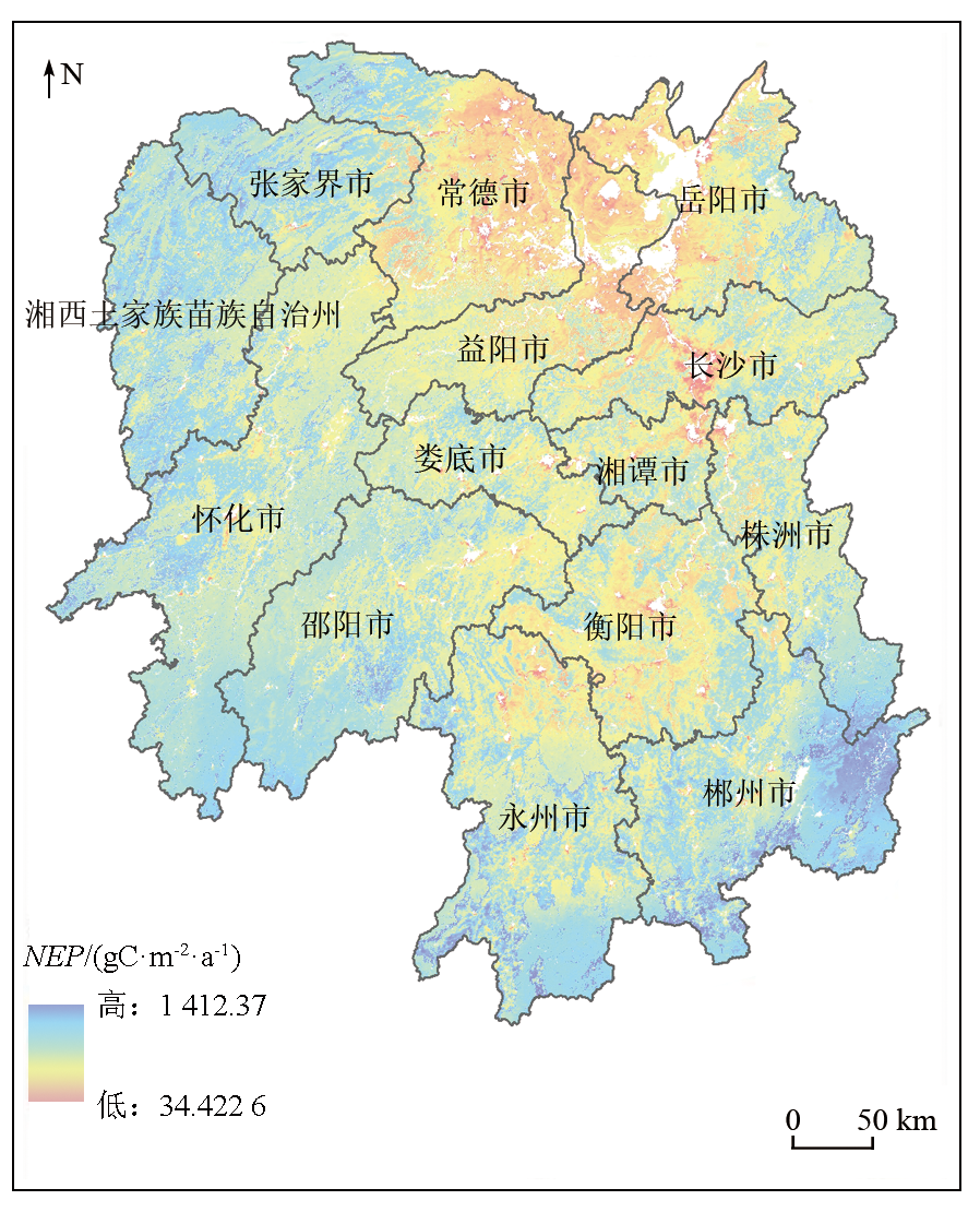
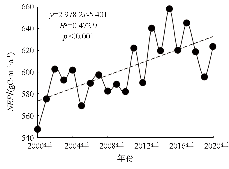
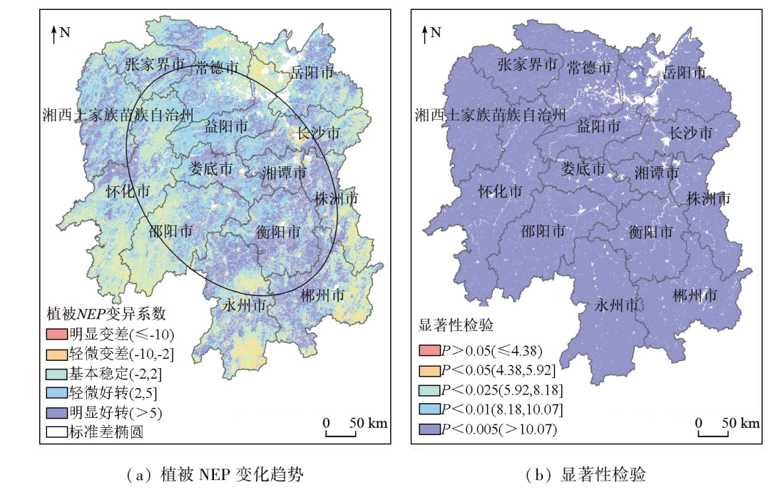
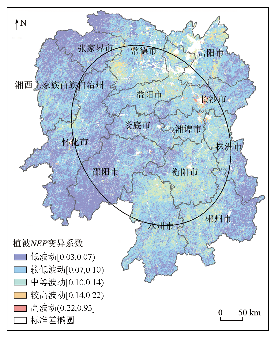
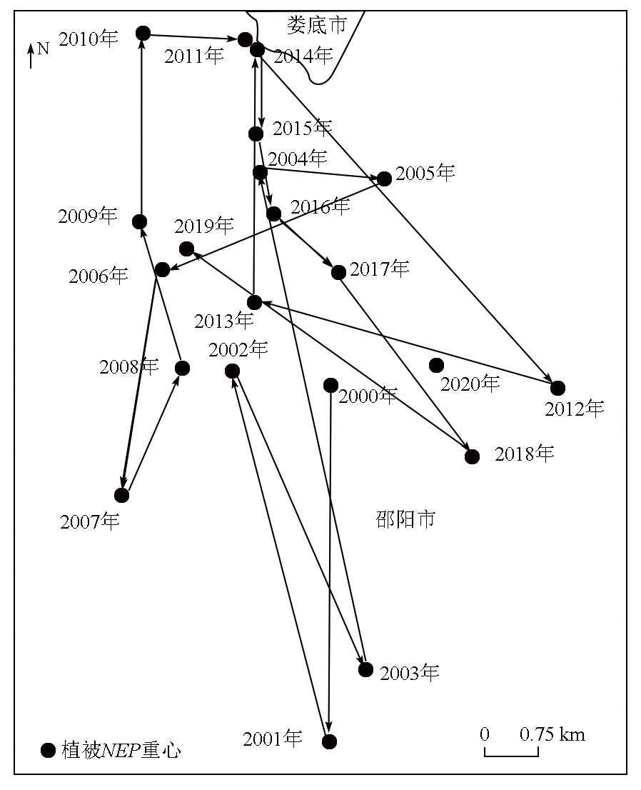
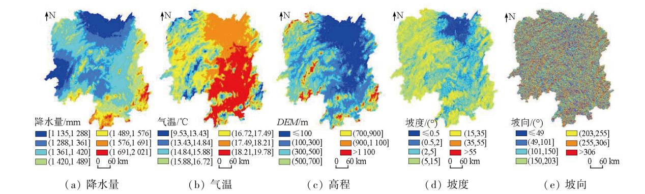
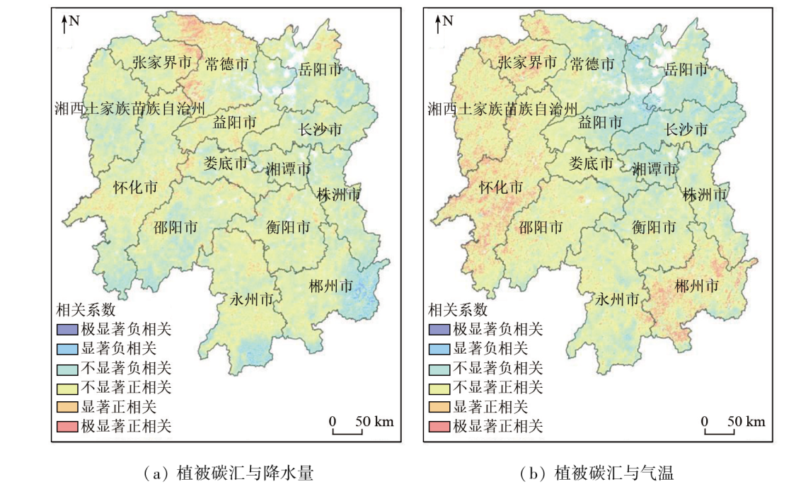
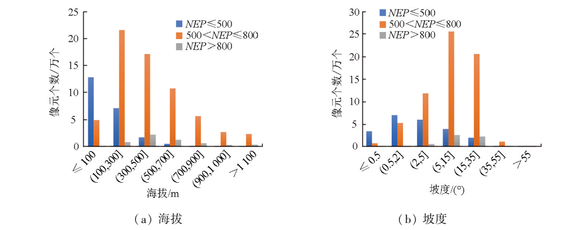
Abstract Net ecosystem productivity (NEP) is recognized as an important characteristic quantity of ecosystems and a physical quantity of carbon exchange between terrestrial ecosystems and the atmosphere. Utilizing MODIS NPP and meteorological data, this study estimated the vegetation NEP in Hunan Province from 2000 to 2020 using a soil microbial respiration model. Furthermore, this study analyzed the dynamic characteristics of vegetation carbon sink through trend analysis, variation coefficient, and standard deviation ellipse methods, followed by a quantitative assessment of the impacts of natural factors on vegetation carbon sink using geographical detectors and correlation analysis. The results indicate that the annual multiyear average of vegetation carbon sink in Hunan Province was 603.01 gC·m-2·a-1. The vegetation carbon sink presented a spatial distribution pattern of higher values in the south and west and lower values in the north and east, decreasing gradually from southwest to northeast. From 2000 to 2020, the average trend coefficient of vegetation carbon sink was 2.97 gC·m-2·a-1, trending upward overall. The coefficient of variation was primarily characterized by small fluctuations and fairly small fluctuations, while areas of great fluctuations are mainly scattered around certain cities, which are more susceptible to natural or anthropogenic disturbances. The variations in vegetation carbon sink in Hunan Province result from multiple factors, with the explanatory power of various factors decreased in the order of altitude, slope, temperature, precipitation, and slope. Both altitude and slope exhibited strong explanatory power regarding the spatiotemporal distribution of vegetation carbon sink in Hunan Province, while temperature and precipitation demonstrated weaker explanatory power. Areas where vegetation carbon sink was positively correlated with temperature and precipitation accounted for 75.13% and 73.11% of the total vegetation area, respectively.
|
| Keywords
vegetation carbon sink
net ecosystem productivity (NEP)
dynamic change
driving factors
Hunan Province
|
|
|
|
Issue Date: 23 December 2024
|
|
|
| [1] |
Rogelj J, Schaeffer M, Meinshausen M, et al. Zero emission targets as long-term global goals for climate protection[J]. Environmental Research Letters, 2015, 10(10):105007.
|
| [2] |
胡鞍钢. 中国实现2030年前碳达峰目标及主要途径[J]. 北京工业大学学报(社会科学版), 2021, 21(3):1-15.
|
| [2] |
Hu A G. China’s goal of achieving carbon peak by 2030 and its main approaches[J]. Journal of Beijing University of Technology (Social Sciences Edition), 2021, 21(3):1-15.
|
| [3] |
Wang Q F, Zheng H, Zhu X J, et al. Primary estimation of Chinese terrestrial carbon sequestration during 2001-2010[J]. Science Bulletin, 2015, 60(6):577-590.
|
| [4] |
方精云, 郭兆迪, 朴世龙, 等. 1981—2000年中国陆地植被碳汇的估算[J]. 中国科学(D辑:地球科学), 2007, 37(6):804-812.
|
| [4] |
Fang J Y, Guo Z D, Piao S L, et al. Estimation of carbon sinks of terrestrial vegetation in China from 1981 to 2000[J]. Science in China (Series D (Earth Sciences)), 2007, 37(6):804-812.
|
| [5] |
Chen J M, Ju W M, Ciais P, et al. Vegetation structural change since 1981 significantly enhanced the terrestrial carbon sink[J]. Nature Communications, 2019, 10(1):4259.
doi: 10.1038/s41467-019-12257-8
pmid: 31534135
|
| [6] |
潘竟虎, 文岩. 中国西北干旱区植被碳汇估算及其时空格局[J]. 生态学报, 2015, 35(23):7718-7728.
|
| [6] |
Pan J H, Wen Y. Estimation and spatial-temporal characteristics of carbon sink in the arid region of Northwest China[J]. Acta Ecologica Sinica, 2015, 35(23):7718-7728.
|
| [7] |
刘凤, 曾永年. 2000—2015年青海高原植被碳源/汇时空格局及变化[J]. 生态学报, 2021, 41(14):5792-5803.
|
| [7] |
Liu F, Zeng Y N. Analysis of the spatio-temporal variation of vegetation carbon source/sink in Qinghai Plateau from 2000—2015[J]. Acta Ecologica Sinica, 2021, 41(14):5792-5803.
|
| [8] |
Yang H F, Chen W. Spatio-temporal pattern of urban vegetation carbon sink and driving mechanisms of human activities in Huaibei,China[J]. Environmental Science and Pollution Research International, 2022, 29(21):31957-31971.
|
| [9] |
冯艾琳, 武晋雯, 孟莹, 等. 基于MODIS GPP数据产品的辽宁省碳源/汇空间格局分布研究[J]. 遥感技术与应用, 2019, 34(4):857-864.
doi: 10.11873/j.issn.1004-0323.2019.4.0857
|
| [9] |
Feng A L, Wu J W, Meng Y, et al. Research on spatial distribution of carbon source/sink of Liaoning Province based on MODIS GPP data products[J]. Remote Sensing Technology and Application, 2019, 34(4):857-864.
|
| [10] |
张继平, 刘春兰, 郝海广, 等. 基于MODIS GPP/NPP数据的三江源地区草地生态系统碳储量及碳汇量时空变化研究[J]. 生态环境学报, 2015, 24(1):8-13.
doi: 10.16258/j.cnki.1674-5906.2015.01.002
|
| [10] |
Zhang J P, Liu C L, Hao H G, et al. Spatial-temporal change of carbon storage and carbon sink of grassland ecosystem in the three-river headwaters region based on MODIS GPP/NPP data[J]. Ecology and Environmental Sciences, 2015, 24(1):8-13.
|
| [11] |
王川, 刘永昌, 李稚. 塔里木河下游生态输水对植被碳源/汇空间格局的影响[J]. 干旱区地理, 2021, 44(3):729-738.
doi: 10.12118/j.issn.1000–6060.2021.03.15
|
| [11] |
Wang C, Liu Y C, Li Z. Effects of ecological water conveyance on the spatial pattern of vegetation carbon sources/sinks in the lower reaches of Tarim River[J]. Arid Land Geography, 2021, 44(3):729-738.
doi: 10.12118/j.issn.1000–6060.2021.03.15
|
| [12] |
贠银娟, 赵军. 基于MODIS-NDVI数据的植被碳汇空间格局研究——以石羊河流域为例[J]. 山地学报, 2018, 36(4):644-653.
|
| [12] |
Yun Y J, Zhao J. Spatial pattern of vegetation carbon sinks based on MODIS-NDVI data:A case study in Shiyang River Basin,China[J]. Mountain Research, 2018, 36(4):644-653.
|
| [13] |
何源, 李星锐, 杨晓帆, 等. 内蒙古锡林郭勒盟典型草原固碳量及固碳潜力估算[J]. 草地学报, 2021, 29(10):2274-2285.
doi: 10.11733/j.issn.1007-0435.2021.10.019
|
| [13] |
He Y, Li X R, Yang X F, et al. The estimation of actual and potential carbon sequestration in typical steppe in Xilingol Country,Inner Mongolia[J]. Acta Agrestia Sinica, 2021, 29(10):2274-2285.
|
| [14] |
陈迎. 碳中和概念再辨析[J]. 中国人口·资源与环境, 2022, 32(4):1-12.
|
| [14] |
Chen Y. A re-analysis of the concept of carbon neutrality[J]. China Population,Resources and Environment, 2022, 32(4):1-12.
|
| [15] |
苏利阳. 碳达峰、碳中和纳入生态文明建设整体布局的战略设计研究[J]. 环境保护, 2021, 49(16):6-9.
|
| [15] |
Su L Y. Research on the strategy of integrating carbon peak and carbon neutrality into the overall layout of ecological civilization construction[J]. Environmental Protection, 2021, 49(16):6-9.
|
| [16] |
陈晓玲, 曾永年. 亚热带山地丘陵区植被NPP时空变化及其与气候因子的关系——以湖南省为例[J]. 地理学报, 2016, 71(1):35-48.
doi: 10.11821/dlxb201601003
|
| [16] |
Chen X L, Zeng Y N. Spatial and temporal variability of the net primary production(NPP) and its relationship with climate factors in subtropical mountainous and hilly regions of China:A case study in Hunan Province[J]. Acta Geographica Sinica, 2016, 71(1):35-48.
|
| [17] |
闫妍, 覃金华, 房磊, 等. 湖南省植被净初级生产力时空动态及其与气候因素的关系[J]. 生态学杂志, 2022, 41(8):1535-1544.
|
| [17] |
Yan Y, Qin J H, Fang L, et al. Spatiotemporal dynamics of vegetation net primary productivity and its relationships with climatic factors in Hunan Province[J]. Chinese Journal of Ecology, 2022, 41(8):1535-1544.
doi: DOI: 10.13292/j.1000-4890.202208.015
|
| [18] |
李家湘, 游健荣, 徐永福, 等. 湖南植被研究:植被类型、组成和分布格局[J]. 中国科学:生命科学, 2021, 51(3):275-288.
|
| [18] |
Li J X, You J R, Xu Y F, et al. Vegetation research in Hunan Province:Vegetation types,composition,and distribution pattern[J]. Scientia Sinica (Vitae), 2021, 51(3):275-288.
|
| [19] |
刘正才, 屈瑶瑶. 基于SPOT-VGT数据的湖南省植被变化及其对气候变化的响应[J]. 北京林业大学学报, 2019, 41(2):80-87.
|
| [19] |
Liu Z C, Qu Y Y. Vegetation change and its response to climate change based on SPOT-VGT in Hunan Province of Southern China[J]. Journal of Beijing Forestry University, 2019, 41(2):80-87.
|
| [20] |
陈雪娇, 周伟, 杨晗. 2001—2017年三江源区典型草地群落碳源/汇模拟及动态变化分析[J]. 干旱区地理, 2020, 43(6):1583-1592.
|
| [20] |
Chen X J, Zhou W, Yang H. Simulation and dynamic change of carbon source/sink in the typical grassland communities in the Three River Source Area from 2001 to 2017[J]. Arid Land Geography, 2020, 43(6):1583-1592.
doi: 10.12118/j.issn.1000-6060.2020.06.20
|
| [21] |
Yang Y H, Shi Y, Sun W J, et al. Terrestrial carbon sinks in China and around the world and their contribution to carbon neutrality[J]. Science China Life Sciences, 2022, 65(5):861-895.
|
| [22] |
汤洁, 姜毅, 李昭阳, 等. 基于CASA模型的吉林西部植被净初级生产力及植被碳汇量估测[J]. 干旱区资源与环境, 2013, 27(4):1-7.
|
| [22] |
Tang J, Jiang Y, Li Z Y, et al. Estimation of vegetation net primary productivity and carbon sink in western Jilin Province based on CASA model[J]. Journal of Arid Land Resources and Environment, 2013, 27(4):1-7.
|
| [23] |
裴志永, 周才平, 欧阳华, 等. 青藏高原高寒草原区域碳估测[J]. 地理研究, 2010, 29(1):102-110.
|
| [23] |
Pei Z Y, Zhou C P, Ouyang H, et al. A carbon budget of alpine steppe area in the Tibetan Plateau[J]. Geographical Research, 2010, 29(1):102-110.
|
| [24] |
王劲峰, 徐成东. 地理探测器:原理与展望[J]. 地理学报, 2017, 72(1):116-134.
doi: 10.11821/dlxb201701010
|
| [24] |
Wang J F, Xu C D. Geodetector:Principle and prospective[J]. Acta Geographica Sinica, 2017, 72(1):116-134.
|
| [25] |
Wang J F, Li X H, Christakos G, et al. Geographical detectors-based health risk assessment and its application in the neural tube defects study of the Heshun region,China[J]. International Journal of Geographical Information Science, 2010, 24(1):107-127.
|
| [26] |
Sha Z Y, Bai Y F, Li R R, et al. The global carbon sink potential of terrestrial vegetation can be increased substantially by optimal land management[J]. Communications Earth and Environment, 2022, 3:8.
|
| [27] |
Luo X, Jia B, Lai X. Contributions of climate change,land use change and CO2 to changes in the gross primary productivity of the Tibetan Plateau[J]. Atmospheric and Oceanic Science Letters, 2020, 13(1):8-15.
|
| [28] |
刘月, 安德帅, 徐丹丹, 等. 垂直带谱上植被群落对气候变化响应的研究进展[J]. 生态科学, 2022, 41(3):245-251.
|
| [28] |
Liu Y, An D S, Xu D D, et al. Review on the vegetation response to climate change in vertical zone spectrum[J]. Ecological Science, 2022, 41(3):245-251.
|
|
Viewed |
|
|
|
Full text
|
|
|
|
|
Abstract
|
|
|
|
|
Cited |
|
|
|
|
| |
Shared |
|
|
|
|
| |
Discussed |
|
|
|
|
 2024,
Vol. 36
2024,
Vol. 36
 ), MO Hongwei(