|
|
 |
|

|
|
|
Spatiotemporal differentiation and responses to climate and mining activities of NDVI in Shaanxi Province from 2001 to 2022 |
YANG Tao1,2( ), WANG Lishe1(), ZHENG Pengpeng3, WANG Peng1,2, ZHAO Hansen1, YANG Shengfei3, ZHAO Jun1,2, XI Rengang1, REN Huaning1, CAI Haojie1,2 ), WANG Lishe1(), ZHENG Pengpeng3, WANG Peng1,2, ZHAO Hansen1, YANG Shengfei3, ZHAO Jun1,2, XI Rengang1, REN Huaning1, CAI Haojie1,2 |
1. Xi’an Center of China Geological Survey, Xi’an 710119, China
2. Technology Innovation Center for Intelligent Remote Sensing Monitoring of Natural Resources in the Upper and Middle Reaches of the Yellow River, MNR, Xi’an 710119, China
3. Xi’an Center of Mineral Resources Survey, China Geological Survey, Xi’an 710100, China |
|
|
|
|
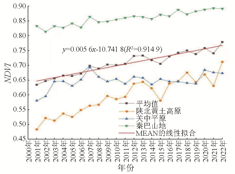
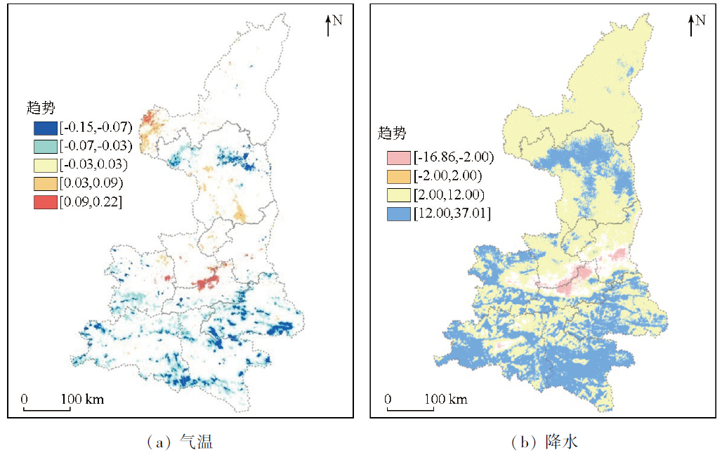
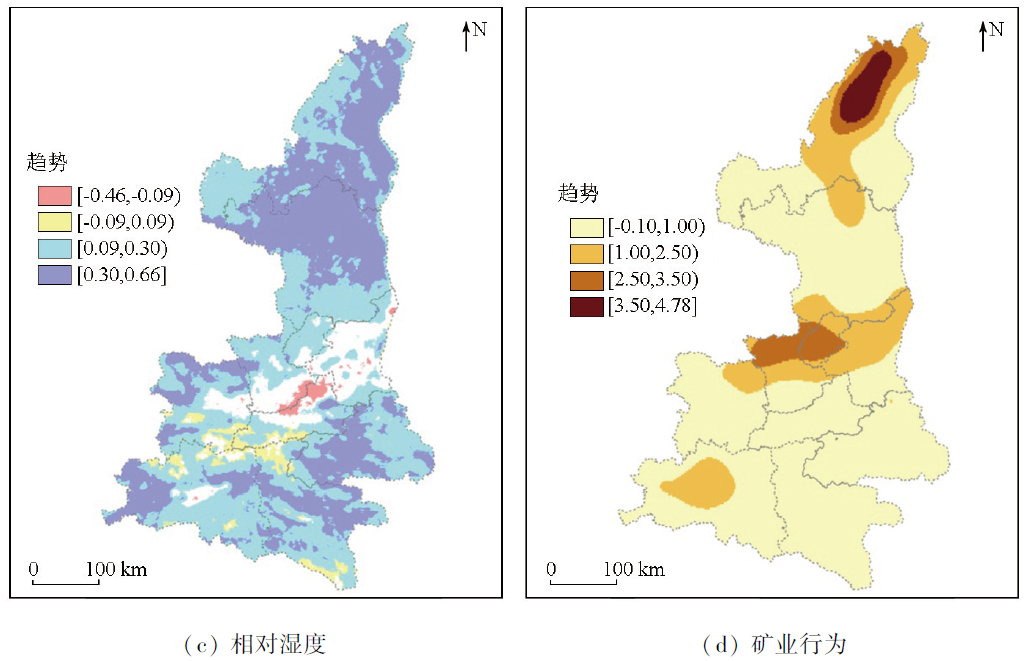
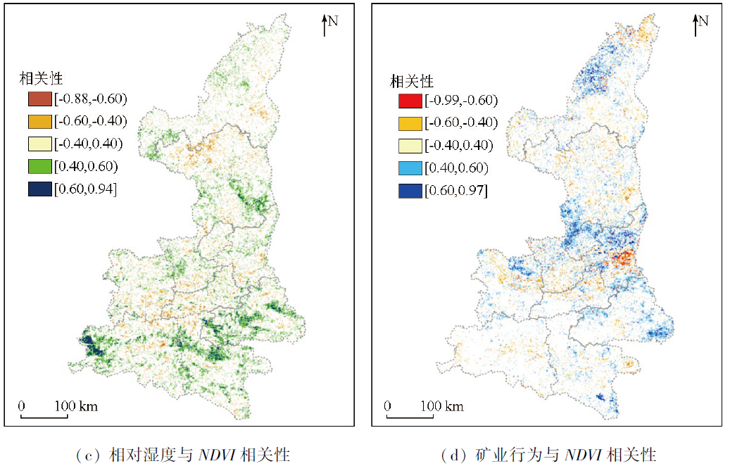
Abstract Shaanxi Province, serving as both one of China’s initial pilot areas for the returning farmland to forestland/grassland project and an important energy supply base in the Yellow River basin, has made substantial investments in mineral resource development and ecological environment protection and restoration in recent years. Based on trend analysis and correlation analysis conducted using MATLAB, this study examined the spatiotemporal differentiation pattern of vegetation ecology and its responses to the dual disturbances of climate conditions and mining activities. The results indicate that from 2001 to 2022, the normalized difference vegetation index (NDVI) of Shaanxi Province exhibited an upward trend while fluctuating, with an average annual increase of 0.006. The lowest NDVI value occurred in 2015. Precipitation acted as the major factor affecting the NDVI of Shaanxi Province. In most areas, NDVI exhibited a significant positive correlation with both precipitation and humidity. The correlation between NDVI and mining activities was increasingly significant with an increase in the mining area. In some energy-based cities, NDVI decreased initially and then increased, exhibiting a V-shaped trend. Overall, mining activity made more positive than negative contributions to changes in NDVI of Shaanxi Province. The results of this study will provide foundational data and a scientific reference for ecological protection and mine restoration and management in Shaanxi Province.
|
| Keywords
NDVI
spatiotemporal differentiation
precipitation
mining activity
correlation
Shaanxi Province
|
|
|
|
Issue Date: 17 February 2025
|
|
|
| [1] |
Fu B, Wang S, Liu Y, et al. Hydrogeomorphic ecosystem responses to natural and anthropogenic changes in the Loess Plateau of China[J]. Annual Review of Earth and Planetary Sciences, 2017, 45(1):223-243.
|
| [2] |
高江波, 焦珂伟, 吴绍洪. 1982—2013年中国植被NDVI空间异质性的气候影响分析[J]. 地理学报, 2019, 74(3):534-543.
doi: 10.11821/dlxb201903010
|
| [2] |
Gao J B, Jiao K W, Wu S H. Revealing the climatic impacts on spatial heterogeneity of NDVI in China during 1982-2013[J]. Acta Geographica Sinica, 2019, 74(3):534-543.
doi: 10.11821/dlxb201903010
|
| [3] |
王建邦, 赵军, 李传华, 等. 2001—2015年中国植被覆盖人为影响的时空格局[J]. 地理学报, 2019, 74(3):504-519.
doi: 10.11821/dlxb201903008
|
| [3] |
Wang J B, Zhao J, Li C H, et al. The spatial-temporal patterns of the impact of human activities on vegetation coverage in China from 2001 to 2015[J]. Acta Geographica Sinica, 2019, 74(3):504-519.
doi: 10.11821/dlxb201903008
|
| [4] |
耿庆玲, 陈晓青, 赫晓慧, 等. 中国不同植被类型归一化植被指数对气候变化和人类活动的响应[J]. 生态学报, 2022, 42(9):3557-3568.
|
| [4] |
Geng Q L, Chen X Q, He X H, et al. Vegetation dynamics and its response to climate change and human activities based on different vegetation types in China[J]. Acta Ecologica Sinica, 2022, 42(9):3557-3568.
|
| [5] |
张静, 杜加强, 盛芝露, 等. 1982—2015年黄河流域植被NDVI时空变化及影响因素分析[J]. 生态环境学报, 2021, 30(5):929-937.
doi: 10.16258/j.cnki.1674-5906.2021.05.005
|
| [5] |
Zhang J, Du J Q, Sheng Z L, et al. Spatio-temporal changes of vegetation cover and their influencing factors in the Yellow River basin from 1982 to 2015[J]. Ecology and Environmental Sciences, 2021, 30(5):929-937.
|
| [6] |
Liu X, Zhu X, Pan Y, et al. Vegetation dynamics in Qinling-Daba Mountains in relation to climate factors between 2000 and 2014[J]. Journal of Geographical Sciences, 2016, 26(1):45-58.
doi: 10.1007/s11442-016-1253-8
|
| [7] |
Li J S, Sun W, Li M Y et al. Coupling coordination degree of production,living and ecological spaces and its influencing factors in the Yellow River Basin[J]. Journal of Cleaner Production. 2021,298.
|
| [8] |
卓静, 朱延年, 何慧娟, 等. 生态恢复工程对陕北地区生态系统格局的影响[J]. 生态学报, 2020, 40(23):8627-8637.
|
| [8] |
Zhuo J, Zhu Y N, He H J, et al. Impacts of ecological restoration projects on the ecosystem in the Loess Plateau[J]. Acta Ecologica Sinica, 2020, 40(23):8627-8637.
|
| [9] |
Wu X, Wang S, Fu B, et al. Socio-ecological changes on the Loess Plateau of China after grain to green program[J]. The Science of the Total Environment, 2019,678:565-573.
|
| [10] |
高滢, 孙虎, 徐崟尧, 等. 陕西省植被覆盖时空变化及其对极端气候的响应[J]. 生态学报, 2022, 42(3):1022-1033.
|
| [10] |
Gao Y, Sun H, Xu Y Y, et al. Temporal and spatial variation of vegetation cover and its response to extreme climate in Shaanxi Province[J]. Acta Ecologica Sinica, 2022, 42(3):1022-1033.
|
| [11] |
栾金凯, 刘登峰, 黄强, 等. 近17年陕西榆林植被指数的时空变化及影响因素[J]. 生态学报, 2018, 38(8):2780-2790.
|
| [11] |
Luan J K, Liu D F, Huang Q, et al. Analysis of the spatial-temporal change and impact factors of the vegetation index in Yulin,Shaanxi Province,in the last 17 years[J]. Acta Ecologica Sinica, 2018, 38(8):2780-2790.
|
| [12] |
李蕊, 陈国清, 李玮贤, 等. 基于遥感生态指数的神东矿区1995—2020年生态环境质量的时空变化特征分析[J]. 水土保持通报, 2021, 41(3):143-151.
|
| [12] |
Li R, Chen G Q, Li W X, et al. Spatiotemporal analysis of eco-environmental benefits in Shenfu-Dongsheng mining area during 1995—2020 based on RSEI[J]. Bulletin of Soil and Water Conservation, 2021, 41(3):143-151.
|
| [13] |
庞国伟, 山琳昕, 杨勤科, 等. 陕西省不同地貌类型区植被覆盖度时空变化特征及其影响因素[J]. 长江科学院院报, 2021, 38(3):51-58,76.
doi: 10.11988/ckyyb.201915132021
|
| [13] |
Pang G W, Shan L X, Yang Q K, et al. Vegetation coverage in different landforms of Shaanxi Province:Spatial and temporal variations and influencing factors[J]. Journal of Yangtze River Scientific Research Institute, 2021, 38(3):51-58,76.
|
| [14] |
杨显华, 魏鹏, 吕军, 等. 基于多源遥感的采空塌陷识别技术应用研究[J]. 自然资源遥感, 2022(2):162-167.doi:10.6046/zrzyyg.2021195.
|
| [14] |
Yang X H, Wei P, Lyu J, et al. Application of mining collapse recognition technology based on multi-source remote sensing[J]. Remote Sensing for Natural Resources, 2022(2):162-167.doi:10.6046/zrzyyg.2021195.
|
| [15] |
刘立, 李长安, 高俊华, 等. 多源卫星遥感的湖南矿山违法开采时空变化[J]. 遥感学报, 2022, 26(3):528-540.
|
| [15] |
Liu L, Li C A, Gao J H, et al. Spatiotemporal changes of illegal mining in Hunan mines based on multi-source satellite remote sensing[J]. National Remote Sensing Bulletin, 2022, 26(3):528-540.
|
| [16] |
赵银娣, 卫虹宇, 董霁红, 等. 基于子区域多标签学习的露天煤矿区场景识别[J]. 遥感学报, 2022, 26(9):1849-1858.
|
| [16] |
Zhao Y D, Wei H Y, Dong J H, et al. Opencast coal mine scene recognition based on sub-region multi-label learning[J]. National Remote Sensing Bulletin, 2022, 26(9):1849-1858.
|
| [17] |
高文龙, 苏腾飞, 张圣微, 等. 矿区地物分类及土地利用/覆盖变化动态监测——以海流兔流域为例[J]. 国土资源遥感, 2020, 32(3):232-239.doi:10.6046/zrzyyg.2020418.
|
| [17] |
Gao W L, Su T F, Zhang S W, et al. Classification of objects and LUCC dynamic monitoring in mining area:A case study of Hailiutu watershed[J]. Remote Sensing for Land and Resources, 2020, 32(3):232-239.doi:10.6046/zrzyyg.2020418.
|
| [18] |
Li J, Zipper C E, Donovan P F, et al. Reconstructing disturbance history for an intensively mined region by time-series analysis of Landsat imagery[J]. Environmental Monitoring and Assessment, 2015, 187(9):557.
doi: 10.1007/s10661-015-4766-1
pmid: 26251060
|
| [19] |
Zhu D, Chen T, Niu R, et al. Ecological environment assessment of mining area by using moving window-based remote sensing ecological index[C]// IGARSS 2019-2019 IEEE International Geoscience and Remote Sensing Symposium.Yokohama,Japan. IEEE,2019:9942-9945.
|
| [20] |
Xiao W, Zhang W K, Ye Y M, et al. Is underground coal mining causing land degradation and significantly damaging ecosystems in semi-arid areas? A study from an ecological capital perspective[J]. Land Degradation & Development, 2020, 31(15):1969-1989.
|
| [21] |
范沛薇, 郝蒙蒙, 江东, 等. 基于高分遥感影像的露天矿区土地利用动态监测——以平朔矿区为例[J]. 遥感技术与应用, 2023, 38(2):274-284.
doi: 10.11873/j.issn.1004-0323.2023.2.0274
|
| [21] |
Fan P W, Hao M M, Jiang D, et al. Landuse dynamic monitoring in open-pit mining area based on high-resolution remote sensing ima-ge:A case study of pingshuo mining area[J]. Remote Sensing Technology and Application, 2023, 38(2):274-284.
|
| [22] |
马丽, 田华征, 康蕾. 黄河流域矿产资源开发的生态环境影响与空间管控路径[J]. 资源科学, 2020, 42(1):137-149.
doi: 10.18402/resci.2020.01.14
|
| [22] |
Ma L, Tian H Z, Kang L. Eco-environmental impact and spatial control of mineral resources exploitation in the Yellow River Basin[J]. Resources Science, 2020, 42(1):137-149.
doi: 10.18402/resci.2020.01.14
|
| [23] |
张仙, 李伟, 陈理, 等. 露天开采矿区要素遥感提取研究进展及展望[J]. 自然资源遥感, 2023, 35(2):25-33.doi:10.6046/zrzyyg.2022141.
|
| [23] |
Zhang X, Li W, Chen L, et al. Research progress and prospect of remote sensing-based feature extraction of opencast mining areas[J]. Remote Sensing for Natural Resources, 2023, 35(2):25-33.doi:10.6046/zrzyyg.2022141
|
| [24] |
张少伟, 郭勇, 权红花. 陕西省地理国(省)情监测中的基本地貌类型及划分指标[J]. 测绘标准化, 2012, 28(4):13-16.
|
| [24] |
Zhang S W, Guo Y, Quan H H. Fundamental relief types and their classification index used in provincial geographic conditions monitoring in Shaanxi[J]. Standardization of Surveying and Mapping, 2012, 28(4):13-16.
|
| [25] |
董王仓, 李新林. 中国矿产地质志-陕西卷, 陕西矿产地质:陕西卷陕西矿产地质:普及本[M]. 北京: 地质出版社, 2018.
|
| [25] |
Dong W C, Li X L. Mineral geology of China-Shaanxi volume,mineral geology of Shaanxi:Popular edition[M]. Beijing: Geological Publishing House, 2018.
|
| [26] |
Galvão, Breunig, Teles, et al. Investigation of terrain illumination effects on vegetation indices and VI-derived phenological metrics in subtropical deciduous forests[J]. GIScience & Remote Sensing, 2016, 53(3):360-381.
|
| [27] |
Pandey P C, Mandal V P, Katiyar S, et al. Geospatial approach to assess the impact of nutrients on rice equivalent yield using MODIS sensors’-based MOD13Q1-NDVI data[J]. IEEE Sensors Journal, 2015, 15(11):6108-6115.
|
| [28] |
Didan K. MOD13Q1 MODIS/Terra vegetation indices 16-Day L3 Global 250 m SIN Grid V006[EB/OL]. NASA EOSDIS LP DAAC, 2015.
|
| [29] |
Lovell J L, Graetz R D. Filtering pathfinder AVHRR land NDVI data for Australia[J]. International Journal of Remote Sensing, 2001, 22(13):2649-2654.
|
| [30] |
Jing W L, Yang Y P, Yue X F, et al. A spatial downscaling algorithm for satellite-based precipitation over the Tibetan Plateau based on NDVI,DEM,and land surface temperature[J]. Remote Sensing, 2016, 8(8),655.
|
| [31] |
李维成, 董王仓, 朱雪丽, 等. 陕西主要成矿单元矿产特征及成矿时空域[J]. 矿床地质, 2022, 41(5):1009-1024.
|
| [31] |
Li W C, Dong W C, Zhu X L, et al. Mineral characteristics and ore-forming spatiotemporal domain of main metallogenic units in Shaanxi Province[J]. Mineral Deposits, 2022, 41(5):1009-1024.
|
| [32] |
贺蕾, 潘竟虎, 董磊磊. 基于遥感和微博签到数据的住房空置空间识别[J]. 遥感技术与应用, 2020, 35(4):820-831.
doi: 10.11873/j.issn.1004-0323.2020.4.0820
|
| [32] |
He L, Pan J H, Dong L L. Study on the spatial identification of housing vacancy[J]. Remote Sensing Technology and Application, 2020, 35(4):820-831.
|
| [33] |
周璞, 侯华丽, 吴尚昆. 我国矿产资源自然区划研究[J]. 中国矿业, 2019, 28(2):29-33.
|
| [33] |
Zhou P, Hou H L, Wu S K. Preliminary study on natural zoning of mineral resources in China[J]. China Mining Magazine, 2019, 28(2):29-33.
|
| [34] |
Yin L C, Wang X F, Feng X M, et al. A comparison of SSEBop-model-based evapotranspiration with eight evapotranspiration products in the Yellow River basin,China[J]. Remote Sensing, 2020, 12(16),2528.
|
| [35] |
刘静, 温仲明, 刚成诚. 黄土高原不同植被覆被类型NDVI对气候变化的响应[J]. 生态学报, 2020, 40(2):678-691.
|
| [35] |
Liu J, Wen Z M, Gang C C. Normalized difference vegetation index of different vegetation cover types and its responses to climate change in the Loess Plateau[J]. Acta Ecologica Sinica, 2020, 40(2):678-691.
|
| [36] |
李璠, 徐维新. 2000—2015年青海省不同功能区NDVI时空变化分析[J]. 草地学报, 2017, 25(4):701-710.
doi: 10.11733/j.issn.1007-0435.2017.04.003
|
| [36] |
Li F, Xu W X. Spatial and temporal variation of NDVI in different functional areas of Qinghai from 2000 to 2015[J]. Acta Agrestia Sinica, 2017, 25(4):701-710.
doi: 10.11733/j.issn.1007-0435.2017.04.003
|
| [37] |
曹巍, 黄麟, 肖桐, 等. 人类活动对中国国家级自然保护区生态系统的影响[J]. 生态学报, 2019, 39(4):1338-1350.
|
| [37] |
Cao W, Huang L, Xiao T, et al. Effects of human activities on the ecosystems of China’s national nature reserves[J]. Acta Ecologica Sinica, 2019, 39(4):1338-1350.
|
| [38] |
中国地质调查局. 国土资源地质大调查成果总结报告(1999—2010年) [R]. 北京: 地质出版社, 2012,1-220.
|
| [38] |
China Geological Survey Bureau. Summary report of the New Round Land and Resources Geological Survey(1999—2010)[R]. Beijing: Geological Publishing House, 2012,1-220.
|
| [39] |
Yang R J, Chen H, Chen S, et al. Spatiotemporal evolution and prediction of land use/land cover changes and ecosystem service variation in the Yellow River basin,China[J]. Ecological Indicators,https://doi.org/10.1016/j.ecolind.2022.109579.
url: https://doi.org/10.1016/j.ecolind.2022.109579.
|
| [40] |
殷崎栋, 柳彩霞, 田野. 基于MODIS NDVI数据的陕西省植被绿度时空变化及人类活动影响[J]. 生态学报, 2021, 41(4):1571-1582.
|
| [40] |
Yin Q D, Liu C X, Tian Y. Spatio-temporal greenness and anthropogenic analysis in Shaanxi based on MODIS NDVI from 2001 to 2018[J]. Acta Ecologica Sinica, 2021, 41(4):1571-1582.
|
| [41] |
刘小燕, 崔耀平, 董金玮, 等. 黄河中下游影响区生态空间和生态指数变化评估[J]. 生态学报, 2021, 41(20):8030-8039.
|
| [41] |
Liu X Y, Cui Y P, Dong J W, et al. Assessment of ecological space and ecological index changes in the affected area of the middle and lower reaches of the Yellow River[J]. Acta Ecologica Sinica, 2021, 41(20):8030-8039.
|
| [42] |
Jiang H, Xu X, Guan M, et al. Determining the contributions of climate change and human activities to vegetation dynamics in agro-pastural transitional zone of Northern China from 2000 to 2015[J]. The Science of the Total Environment, 2020,718:134871.
|
| [43] |
韩红珠, 白建军, 张波, 等. 基于MODIS时序的陕西省植被物候时空变化特征分析[J]. 国土资源遥感, 2018, 30(4):125-131.doi:10.6046/gtzyyg.2018.04.19.
|
| [43] |
Han H Z, Bai J J, Zhang B, et al. Spatial-temporal characteristics of vegetation phenology in Shaanxi Province based on MODIS time series[J]. Remote Sensing for Land and Resources, 2018, 30(4):125-131.doi:10.6046/gtzyyg.2018.04.19.
|
| [44] |
牟乐, 芦奕晓, 杨慧敏, 等. 1981—2015年中国西北牧区植被覆盖的时空变化[J]. 干旱区研究, 2018, 35(3):615-623.
doi: 10.13866/j.azr.2018.03.14
|
| [44] |
Mou L, Lu Y X, Yang H M, et al. Spatiotemporal variation of vegetation cover in the pastoral area in northwestern China during the period of 1981—2015[J]. Arid Zone Research, 2018, 35(3):615-623.
|
| [45] |
刘宪锋, 朱秀芳, 潘耀忠, 等. 1982—2012年中国植被覆盖时空变化特征[J]. 生态学报, 2015, 35(16):5331-5342.
|
| [45] |
Liu X F, Zhu X F, Pan Y Z, et al. Spatiotemporal changes in vegetation coverage in China during 1982—2012[J]. Acta Ecologica Sinica, 2015, 35(16):5331-5342.
|
| [46] |
徐省超, 赵雪雁, 宋晓谕. 退耕还林(草)工程对渭河流域生态系统服务的影响[J]. 应用生态学报, 2021, 32(11):3893-3904.
doi: 10.13287/j.1001-9332.202111.005
|
| [46] |
Xu X C, Zhao X Y, Song X Y. Impacts of the returning farmland to forest (grassland) project on ecosystem services in the Weihe River basin,China[J]. Chinese Journal of Applied Ecology, 2021, 32(11):3893-3904.
|
| [47] |
岳辉, 刘英. 近15 a陕西省植被时空变化与影响因素分析[J]. 干旱区地理, 2019, 42(2):314-323.
|
| [47] |
Yue H, Liu Y. Vegetation spatiotemporal variation and its driving factors of Shaanxi Province in recent 15 years[J]. Arid Land Geography, 2019, 42(2):314-323.
doi: 10.12118/j.issn.1000-6060.2019.02.11
|
| [48] |
张景华, 封志明, 姜鲁光, 等. 澜沧江流域植被NDVI与气候因子的相关性分析[J]. 自然资源学报, 2015, 30(9):1425-1435.
|
| [48] |
Zhang J H, Feng Z M, Jiang L G, et al. Analysis of the correlation between NDVI and climate factors in the Lancang River basin[J]. Journal of Natural Resources, 2015, 30(9):1425-1435.
doi: 10.11849/zrzyxb.2015.09.001
|
| [49] |
卢乔倩, 江涛, 柳丹丽, 等. 中国不同植被覆盖类型 NDVI对气温和降水的响应特征[J]. 生态环境学报, 2020, 29(1):23-34.
doi: 10.16258/j.cnki.1674-5906.2020.01.003
|
| [49] |
Lu Q Q, Jiang T, Liu D L, et al. The response characteristics of NDVI with different vegetation cover types to temperature and precipitation in China[J]. Ecology and Environmental Sciences, 2020, 29(1):23-34.
|
| [50] |
Yang H F, Yao L, Wang Y B, et al. Relative contribution of climate change and human activities to vegetation degradation and restoration in North Xinjiang,China[J]. The Rangeland Journal, 2017, 39(3):289-302.
|
| [51] |
Fabricante I, Oesterheld M, Paruelo J. Annual and seasonal variation of NDVI explained by current and previous precipitation across Northern Patagonia[J]. Journal of Arid Environments, 2009, 73(8):745-753.
|
| [52] |
赵明伟, 王妮, 施慧慧, 等. 2001—2015年间我国陆地植被覆盖度时空变化及驱动力分析[J]. 干旱区地理, 2019, 42(2):324-331.
|
| [52] |
Zhao M W, Wang N, Shi H H, et al. Spatial-temporal variation and its driving forces of vegetation coverage in China from 2001 to 2015[J]. Arid Land Geography, 2019, 42(2):324-331.
doi: 10.12118/j.issn.1000-6060.2019.02.12
|
| [53] |
成方妍, 刘世梁, 尹艺洁, 等. 基于MODIS NDVI的广西沿海植被动态及其主要驱动因素[J]. 生态学报, 2017, 37(3):788-797.
|
| [53] |
Cheng F Y, Liu S L, Yin Y J, et al. The dynamics and main driving factors of coastal vegetation in Guangxi based on MODIS NDVI[J]. Acta Ecologica Sinica, 2017, 37(3):788-797.
|
| [54] |
刘敬, 杨金虎, 段少帅, 等. 生态文明视阈下矿业治理共同体探索——以陕西为例[J]. 金属矿山, 2019(6):173-178.
|
| [54] |
Liu J, Yang J H, Duan S S, et al. Research on the mining governance community under the perspective of ecological civilization:Taking Shaanxi Province as an example[J]. Metal Mine, 2019(6):173-178.
|
| [55] |
周静. 市场化方式推进矿山生态修复的实施路径与思考[J]. 中国矿业, 2022, 31(7):61-64.
|
| [55] |
Zhou J. Thinking and implementation approach of using market-oriented ways to promote the ecological restoration of mines[J]. China Mining Magazine, 2022, 31(7):61-64.
|
| [56] |
杨金中, 许文佳, 姚维岭, 等. 全国采矿损毁土地分布与治理状况及存在问题[J]. 地学前缘, 2021, 28(4):83-89.
doi: 10.13745/j.esf.sf.2020.10.8
|
| [56] |
Yang J Z, Xu W J, Yao W L, et al. Land destroyed by mining in China:Damage distribution,rehabilitation status and existing problems[J]. Earth Science Frontiers, 2021, 28(4):83-89.
|
| [57] |
孙灏, 胡佳琪, 崔雅静, 等. 基于多源遥感数据的生态系统服务功能时空演变趋势分析[J]. 测绘通报, 2021(4):1-7.
doi: 10.13474/j.cnki.11-2246.2021.0101
|
| [57] |
Sun H, Hu J Q, Cui Y J, et al. Spatiotemporal evolution of ecosystem service functions based on multi-source remote sensing data[J]. Bulletin of Surveying and Mapping, 2021(4):1-7.
doi: 10.13474/j.cnki.11-2246.2021.0101
|
| [58] |
陈建平, 范立民, 杜江丽, 等. 陕西省矿山地质环境治理现状及变化趋势分析[J]. 中国煤炭地质, 2014, 26(9):54-56,64.
|
| [58] |
Chen J P, Fan L M, Du J L, et al. Mine geological environment governing status quo and variation trend analysis in Shaanxi Province[J]. Coal Geology of China, 2014, 26(9):54-56,64.
|
| [59] |
陕西省自然资源厅. 陕西绿色矿山建设初见成效[EB/OL].(2017-09-11) [2023-10-25].https://zrzyt.shaanxi.gov.cn/info/1038/35413.htm.
url: https://zrzyt.shaanxi.gov.cn/info/1038/35413.htm
|
| [59] |
Department of Natural Resources of Shannxi Province. The construction of green mines in Shannxi has achieved initial results.[EB/OL].(2017-09-11) [2023-10-25].https://zrzyt.shaanxi.gov.cn/info/1038/35413.htm.
url: https://zrzyt.shaanxi.gov.cn/info/1038/35413.htm
|
| [60] |
张海东, 田婷, 张青, 等. 基于GF-1影像的耕地地块破碎区水稻遥感提取[J]. 遥感技术与应用, 2019, 34(4):785-792.
doi: 10.11873/j.issn.1004-0323.2019.4.0785
|
| [60] |
Zhang H D, Tian T, Zhang Q, et al. Study on extraction of paddy rice planting area in low fragmented regions based on GF-1 WFV images[J]. Remote Sensing Technology and Application, 2019, 34(4):785-792.
|
| [61] |
钱琛, 陈海滨, 侯现慧. 生态建设背景下陕西省植被覆盖时空变化及其影响因素研究[J]. 干旱区地理, 2020, 43(2):425-433.
|
| [61] |
Qian C, Chen H B, Hou X H. Temporal and spatial variation of vegetation cover and its influencing factors in Shaanxi Province in the context of ecological construction[J]. Arid Land Geography, 2020, 43(2):425-433.
|
| [62] |
王朗, 傅伯杰, 吕一河, 等. 生态恢复背景下陕北地区植被覆盖的时空变化[J]. 应用生态学报, 2010, 21(8):2109-2116.
|
| [62] |
Wang L, Fu B J, Lyu Y H, et al. Spatio-temporal variations of vegetation cover in northern Shaanxi Province under the background of ecological restoration[J]. Chinese Journal of Applied Ecology, 2010, 21(8):2109-2116.
|
| [63] |
康帅直, 穆琪, 赵永华, 等. 黄土高原神府资源开采区生态环境质量时空格局特征[J]. 生态学报, 2023, 43(7):2781-2792.
|
| [63] |
Kang S Z, Mu Q, Zhao Y H, et al. Temporal and spatial pattern characteristics of ecological environmental quality in Shenfu mining area of Loess Plateau[J]. Acta Ecologica Sinica, 2023, 43(7):2781-2792.
|
|
Viewed |
|
|
|
Full text
|
|
|
|
|
Abstract
|
|
|
|
|
Cited |
|
|
|
|
| |
Shared |
|
|
|
|
| |
Discussed |
|
|
|
|
 2025,
Vol. 37
2025,
Vol. 37