|
|
|
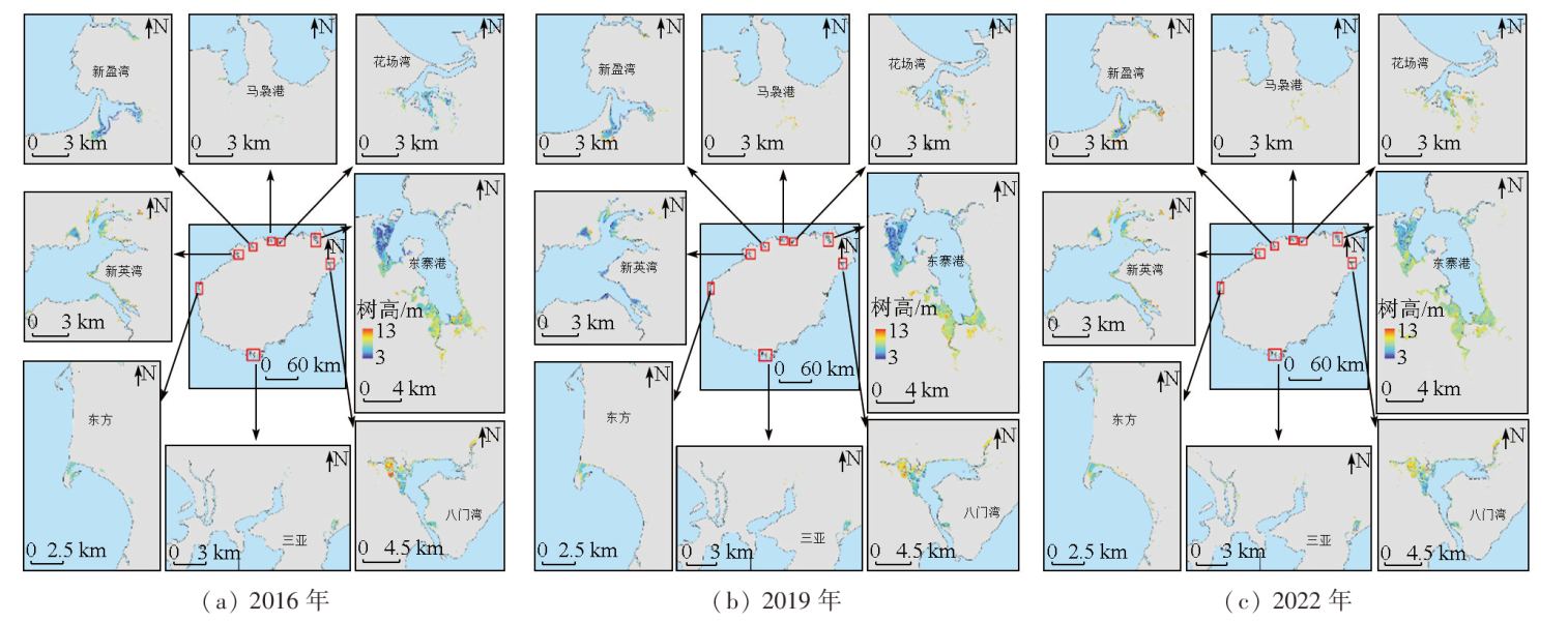
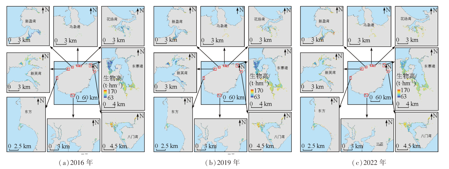
Abstract The change in carbon stocks is recognized as an important indicator of the carbon pool function. The effective, accurate assessment of carbon stocks is of great significance for research on regional carbon cycle and carbon source/sink dynamics, climate change mitigation, and regional sustainable development. Based on multi-time series remote sensing images (Sentinel-1 and Sentinel-2) and the Google Earth Engine (GEE) cloud computing platform, this study matched the photon point data of ICESat-2-derived vegetation canopy for the inversion of mangrove forest heights. Then, the inversion of the biomass of mangrove forests was conducted using a large-scale tree height-biomass model. Consequently, the heights, above-ground biomass, and carbon stocks of mangrove forests in Hainan Island were obtained, and their distribution and variations were further analyzed. The results indicate that in 2016, 2019, and 2022, mangrove forests in Hainan Island exhibited average heights of 6.99 m, 7.26 m, and 7.71 m, respectively, with an increasing trend observed in the highlights across all regions in the three years. Their total above-ground biomass was 400 939.48 t, 411 928.64 t, and 458 759.02 t, respectively, with average densities of 110.23 t/hm2, 114.61 t/hm2, and 120.02 t/hm2, respectively. The above-ground biomass of Dongzhai Port and the Bamenwan area, both located in the northeastern part of Hainan, accounted for about 80% of the total. The carbon stocks of mangrove forests exhibited rates of increase ranging from 1% to 4.45% over the three years, with the top two growth rates occurring in Dongzhai Port and the Bamenwan area, respectively (4.45% and 3.17%). The results of this study can provide foundational data and a methodological reference for assessing carbon stocks of large-scale mangrove forests and serve as important parameters for mangrove forest management and protection in Hainan Island, holding THE value of widespread applications.
|
| Keywords
mangrove forest
carbon stock
biomass
Google Earth Engine
Hainan Island
|
|
|
|
Issue Date: 09 May 2025
|
|
|
| [1] |
自然资源部海洋预警监测司. 红树林生态系统碳储量调查与评估技术规程[S]. 北京: 自然资源部, 2023.
|
| [1] |
Marine Warning and Monitoring Department,Ministry of Natural Resources. Technical specification for investigation and assessment of carbon stocks in mangrove ecosystem[S]. Beijing: Ministry of Natural Resources, 2023.
|
| [2] |
陈光程, 陈顺洋, 陈彬, 等. 红树林生态修复手册[R]. 厦门: 自然资源部第三海洋研究所, 2021.
|
| [2] |
Chen G C, Chen S Y, Chen B, et al. Mangrove ecological restoration manual[R]. Xiamen: Third institute of oceanography,Ministry of Natural Resources, 2021.
|
| [3] |
Omar H, Misman M A, Ismail P. Status of mangroves in malaysia[M]. Kuala Lumpur: Forest research Institute Malaysia, 2020.
|
| [4] |
Tian Y, Huang H, Zhou G, et al. Aboveground mangrove biomass estimation in Beibu Gulf using machine learning and UAV remote sensing[J]. Science of the Total Environment, 2021, 781:146816.
|
| [5] |
贾凯, 陈水森, 蒋卫国. 粤港澳大湾区红树林长时间序列遥感监测[J]. 遥感学报, 2022, 26(6):1096-1111.
|
| [5] |
Jia K, Chen S S, Jiang W G. Long time-series remote sensing monitoring of mangrove forests in the Guangdong-Hong Kong-Macao Greater Bay Area[J]. National Remote Sensing Bulletin, 2022, 26(6):1096-1111.
|
| [6] |
Chen B, Xiao X, Li X, et al. A mangrove forest map of China in 2015:Analysis of time series Landsat 7/8 and Sentinel-1A imagery in Google Earth Engine cloud computing platform[J]. ISPRS Journal of Photogrammetry and Remote Sensing, 2017, 131:104-120.
|
| [7] |
Hu L, Xu N, Liang J, et al. Advancing the mapping of mangrove forests at national-scale using sentinel-1 and sentinel-2 time-series data with Google Earth Engine:A case study in China[J]. Remote Sensing, 2020, 12(19):3120.
|
| [8] |
Singha C, Swain K C. Quantifying changes in Sundarbans mangrove forest through GEE cloud computing approach[M]//Proceedings of International Joint Conference on Advances in Computational Intelligence. Singapore: Springer Nature Singapore, 2022:113-129.
|
| [9] |
Aseran A W, Darmawan S, Hernawati R. Estimation of mangrove biomass using Landsat data on Google Earth Engine(GEE) platform[C]// The 42nd Asian Conference on Remote Sensing. Vietnam: Can Tho University, 2021:1-6.
|
| [10] |
李尉尉, 朱建华, 赵文璇, 等. 基于遥感的红树林地上生物量估算研究进展[J]. 海洋技术学报, 2023, 42(5):1-9.
|
| [10] |
Li W W, Zhu J H, Zhao W X, et al. Research advances in estimating aboveground biomass of mangroves based on remote sensing[J]. Journal of Ocean Technology, 2023, 42(5):1-9.
|
| [11] |
Li M S, Lee S Y. Mangroves of China:A brief review[J]. Forest Ecology and Management, 1997, 96(3):241-259
|
| [12] |
Meng Y, Gou R, Bai J, et al. Spatial patterns and driving factors of carbon stocks in mangrove forests on Hainan Island,China[J]. Global Ecology and Biogeography, 2022, 31(9):1692-1706.
|
| [13] |
徐芳. 基于Sentinel-2的红树林提取及碳储量估算研究[D]. 兰州: 兰州交通大学, 2020.
|
| [13] |
Xu F. Mangrove extraction and carbon storage estimation by using Sentinel-2 images[D]. Lanzhou: Lanzhou Jiaotong University, 2020.
|
| [14] |
董佳臣, 倪文俭, 张志玉, 等. ICESat-2植被冠层高度和地表高程数据产品用于森林高度提取的效果评价[J]. 遥感学报, 2021, 25(6):1294-1307.
|
| [14] |
Dong J C, Ni W J, Zhang Z Y, et al. Performance of ICESat-2 ATL08 product on the estimation of forest height by referencing to small footprint LiDAR data[J]. National Remote Sensing Bulletin, 2021, 25(6):1294-1307.
|
| [15] |
Chen B, Pang Y, Li Z, et al. Potential of forest parameter estimation using metrics from photon counting LiDAR data in Howland Research Forest[J]. Remote Sensing, 2019, 11(7):856.
|
| [16] |
Neuenschwander A L, Magruder L A. The potential impact of vertical sampling uncertainty on ICESat-2/ATLAS terrain and canopy height retrievals for multiple ecosystems[J]. Remote Sensing, 2016, 8(12):1039.
|
| [17] |
赵阳, 田震, 李尉尉, 等. 基于Sentinel-2 MSI影像与面向对象相结合的红树林树种精细化分类方法研究[J]. 海洋通报, 2023, 42(3):352-360.
|
| [17] |
Zhao Y, Tian Z, Li W W, et al. Study on the refined classification method of mangrove tree species based on Sentinel-2 MSI images combined with object-oriented[J]. Marine Science Bulletin, 2023, 42(3):352-360.
|
| [18] |
Fatoyinbo T, Feliciano E A, Lagomasino D, et al. Estimating mangrove aboveground biomass from airborne LiDAR data:A case study from the Zambezi River delta[J]. Environmental Research Letters, 2018, 13(2):025012.
|
| [19] |
邓皓天. 基于光学和SAR多源遥感数据的中国东北地区森林参数反演[D]. 长春: 吉林大学, 2022.
|
| [19] |
Deng H T. Research on forest parameter inversion method in northeastern China based on optical and SAR multi-source remote sensi-ng data[D]. Changchun: Jilin University, 2022.
|
| [20] |
Ghosh S M, Behera M D, Paramanik S. Canopy height estimation using Sentinel series images through machine learning models in a mangrove forest[J]. Remote Sensing, 2020, 12(9):1519.
|
| [21] |
Simard M, Rivera-Monroy V H, Mancera-Pineda J E, et al. A systematic method for 3D mapping of mangrove forests based on Shuttle Radar Topography Mission elevation data,ICEsat/GLAS waveforms and field data:Application to Ciénaga Grande de Santa Marta,Colombia[J]. Remote Sensing of Environment, 2008, 112(5):2131-2144.
|
| [22] |
Huang Z, Tian Y, Zhang Q, et al. Estimating mangrove above-ground biomass at Maowei Sea,Beibu Gulf of China using machine learning algorithm with Sentinel-1 and Sentinel-2 data[J]. Geocarto International, 2022, 37(27):15778-15805.
|
| [23] |
吴培强, 任广波, 张程飞, 等. 无人机多光谱和LiDAR的红树林精细识别与生物量估算[J]. 遥感学报, 2022, 26(6):1169-1181.
|
| [23] |
Wu P Q, Ren G B, Zhang C F, et al. Fine identification and biomass estimation of mangroves based on UAV multispectral and LiDAR[J]. National Remote Sensing Bulletin, 2022, 26(6):1169-1181.
|
| [24] |
朱远辉, 柳林, 刘凯, 等. 红树林植物生物量研究进展[J]. 湿地科学, 2014, 12(4):515-526.
|
| [24] |
Zhu Y H, Liu L, Liu K, et al. Progress in researches on plant biomass of mangrove forests[J]. Wetland Science, 2014, 12(4):515-526.
|
| [25] |
闻馨, 刘凯, 曹晶晶, 等. 基于森林冠层高度和异速生长方程的中国红树林地上生物量估算[J]. 热带地理, 2023, 43(1):1-11.
doi: 10.13284/j.cnki.rddl.003616
|
| [25] |
Wen X, Liu K, Cao J J, et al. Estimation of mangrove aboveground biomass in China using forest canopy height through an allometric equation[J]. Tropical Geography, 2023, 43(1):1-11.
doi: 10.13284/j.cnki.rddl.003616
|
| [26] |
Howard J, Hoyt S, Isensee K, et al. Coastal blue carbon:Methods for assessing carbon stocks and emissions factors in mangroves,tidal salt marshes,and seagrasses meadows[M].Arlington,Virginia,USA:Conservation International, Intergovern- mental Oceanographic Commission of UNESCO,International Union for Conservation of Nature, 2014.
|
| [27] |
Saenger P, Snedaker S C. Pantropical trends in mangrove above-ground biomass and annual litterfall[J]. Oecologia, 1993, 96(3):293-299.
doi: 10.1007/BF00317496
pmid: 28313641
|
| [28] |
Kauffman J B, Arifanti V B, Basuki I, et al. Protocols for the measurement,monitoring,and reporting of structure,biomass,carbon stocks and greenhouse gas emissions in tropical peat swamp forests[M]. Indonesia: Center for International Forestry Research (CIFOR), 2016.
|
| [29] |
张莉. 海南清澜港红树林土壤有机碳及其与土壤因子关系研究[D]. 洛阳: 河南科技大学, 2013.
|
| [29] |
Zhang L. Soil organic carbon in mangrove forests and its relationship with soil factor in qinglangang,Hainan[D]. Luoyang: Henan University of Science and Technology, 2013.
|
| [30] |
Wang D, Wan B, Liu J, et al. Estimating aboveground biomass of the mangrove forests on northeast Hainan Island in China using an upscaling method from field plots,UAV-LiDAR data and Sentinel-2 imagery[J]. International Journal of Applied Earth Observation and Geoinformation, 2020, 85:101986.
|
|
Viewed |
|
|
|
Full text
|
|
|
|
|
Abstract
|
|
|
|
|
Cited |
|
|
|
|
| |
Shared |
|
|
|
|
| |
Discussed |
|
|
|
|
 2025,
Vol. 37
2025,
Vol. 37
 ), XUE Zhiyong, ZHU Jianhua(