|
|
 |
|

|
|
|
Monitoring of dynamic changes in water bodies of Henan Province based on time-series Sentinel-2 data |
WEI Xin1( ), REN Yu2, CHEN Xidong1(), HU Qingfeng1, LIU Hui1, ZHOU Jing2, SONG Dongwei3, ZHANG Peipei4, HUANG Zhiquan5 ), REN Yu2, CHEN Xidong1(), HU Qingfeng1, LIU Hui1, ZHOU Jing2, SONG Dongwei3, ZHANG Peipei4, HUANG Zhiquan5 |
1. College of Surveying, Mapping and Geographic Information, North China University of Water Resources and Electric Power, Zhengzhou 450045, China
2. College of Geography and Environmental Sciences, Northwest Normal University, Lanzhou 730070, China
3. Seventh Geological Brigade, Henan Nonferrous Metals Geological and Mineral Bureau, Zhengzhou 450045, China
4. Henan Surveying and Mapping Institute, Zhengzhou 450045, China
5. Luoyang Institute of Science and Technology, Luoyang 471023, China |
|
|
|
|
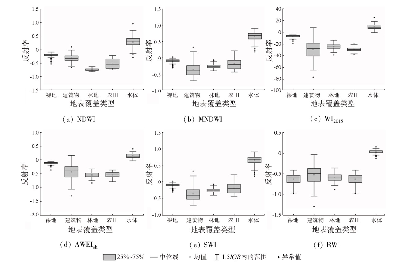
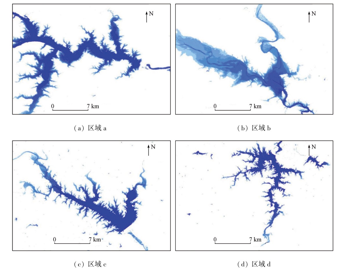
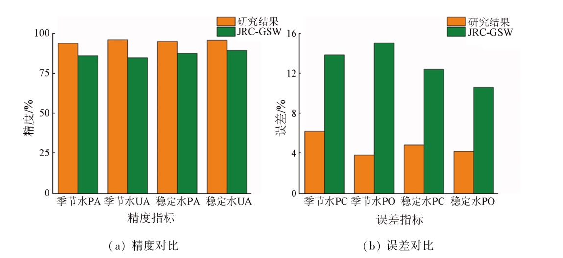
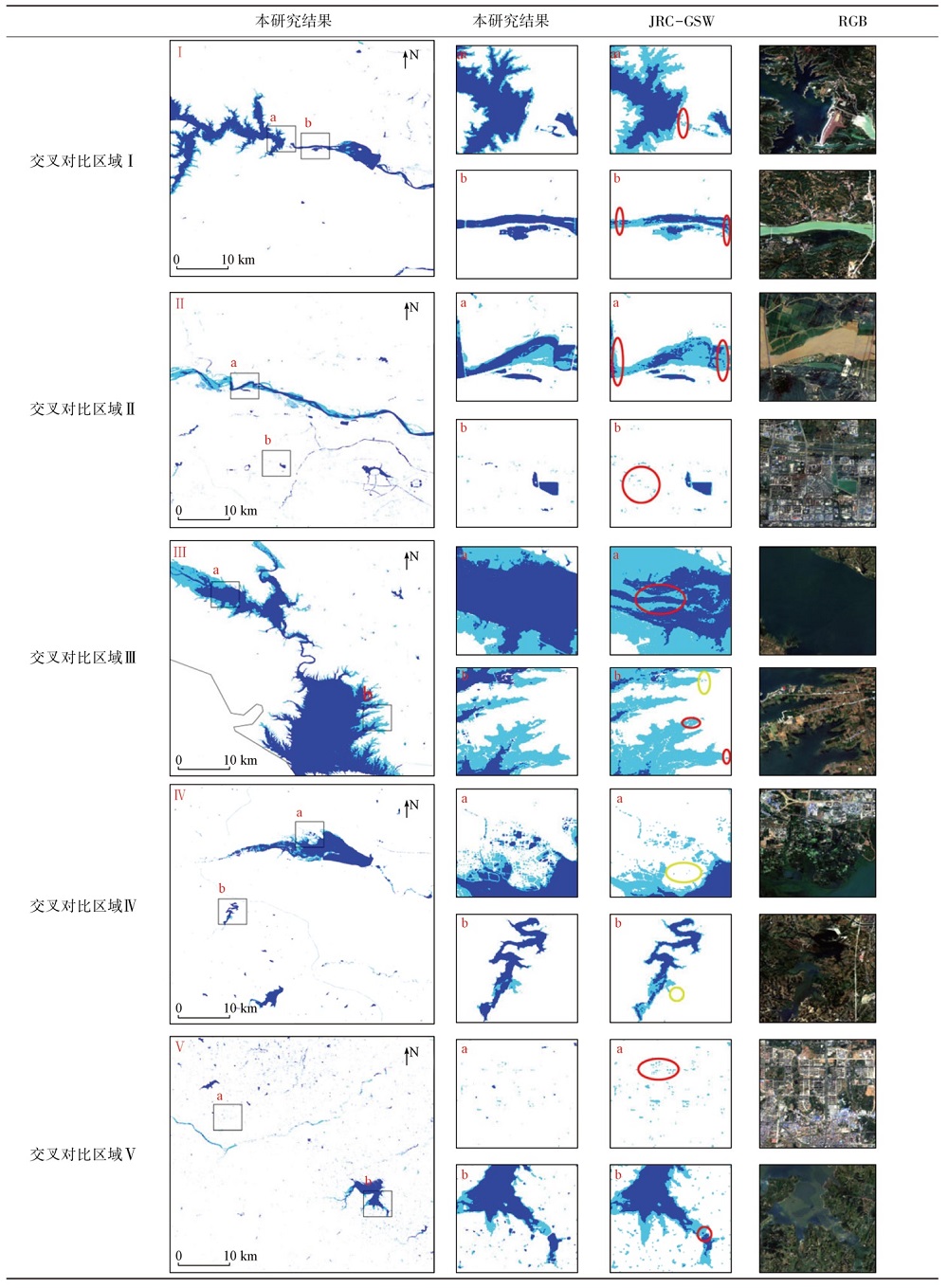
Abstract Inland water bodies, as irreplaceable resources in ecosystems, play a vital role in climate change and regional water circulation. Scientifically and accurately monitoring the distribution and dynamic changes of water bodies is critical for ecosystem balance maintenance, sustainable human development, and early warning of floods and droughts. However, current research primarily focuses on the static monitoring of inland water bodies, lacking high-resolution monitoring of dynamic changes in water bodies. Hence, relying on the Google Earth Engine (GEE) cloud computing platform, this study monitored the dynamic changes of water bodies at a spatial resolution of 10 m, with the Sentinel-2 surface reflectance data in 2020 as the data source. First, the optimal water body monitoring features were selected by examining the features of typical land cover types in Sentinel-2 spectral bands and water indices. Then, an automatic extraction method for water body training datasets was proposed in conjunction with priori water body products, obtaining high-confidence water body training samples. Furthermore, the spectral angle (SA) and Euclidean distance (ED) methods were integrated based on the Dempster-Shafer (D-S) evidence theory model, and a SA-ED dynamic monitoring model for water bodies was developed combined with the extracted optimal water body monitoring features. Finally, the stability of the SA-ED model was tested with Henan Province as a study area, demonstrating that the SA-ED model can effectively monitor the dynamic changes in water bodies. The SA-ED model yielded an overall monitoring accuracy of 97.03% for water bodies in Henan Province, with user accuracy of 95.85% and producer accuracy of 95.17% for permanent water bodies, user and producer accuracies of 96.21% and 93.82% for seasonal water bodies, respectively. The results of this study provide a novel approach for the fine-resolution monitoring of dynamic changes in water bodies.
|
| Keywords
inland water body
water body distribution
dynamic monitoring
Google Earth Engine
Sentinel-2
|
|
|
|
Issue Date: 14 June 2024
|
|
|
| [1] |
Palmer S C J, Kutser T, Hunter P D. Remote sensing of inland waters:Challenges,progress and future directions[J]. Remote Sensing of Environment, 2015, 157:1-8.
|
| [2] |
Carroll M L, Townshend J R, DiMiceli C M, et al. A new global raster water mask at 250 m resolution[J]. International Journal of Digital Earth, 2009, 2(4):291-308.
|
| [3] |
Postel S L. Entering an era of water scarcity:The challenges ahead[J]. Ecological Applications, 2000, 10(4):941.
|
| [4] |
Cole J J, Prairie Y T, Caraco N F, et al. Plumbing the global carbon cycle:Integrating inland waters into the terrestrial carbon budget[J]. Ecosystems, 2007, 10(1):172-185.
|
| [5] |
Li J, Wang S, Wu Y, et al. MODIS observations of watercolor of the largest 10 lakes in China between 2000 and 2012[J]. International Journal of Digital Earth, 2016, 9(8):788-805.
|
| [6] |
Wang X B, Xie S P, Zhang X L, et al. A robust multi-band water index (MBWI) for automated extraction of surface water from Landsat8 OLI imagery[J]. International Journal of Applied Earth Observation and Geoinformation. 2018, 68:73-91.
|
| [7] |
Sharma R C, Tateishi R, Hara K, et al. Developing superfine water index (SWI) for global water cover mapping using MODIS data[J]. Remote Sensing, 2015, 7(10):13807-13841.
|
| [8] |
王随霞. 基于MODIS数据的黄河下游洪水遥感监测研究[D]. 南京: 河海大学, 2006.
|
| [8] |
Wang S X. Remote sensing monitoring of floods in the lower reaches of the Yellow River based on MODIS data[D]. Nanjing: Hohai University, 2006.
|
| [9] |
闵文彬. 长江上游MODIS影像的水体自动提取方法[J]. 高原气象, 2004, 23(s1):141-145.
|
| [9] |
Min W B. A method to identify water-body from MODIS image data in upper reach of Changjiang River[J]. Plateau Meteorology, 2004, 23(s1):141-145.
|
| [10] |
Sun D, Yu Y, Goldberg M D. Deriving water fraction and flood maps from MODIS images using a decision tree approach[J]. IEEE Journal of Selected Topics in Applied Earth Observations and Remote Sensing, 2011, 4(4):814-825.
|
| [11] |
饶品增, 蒋卫国, 王晓雅. 基于MODIS数据的洪涝灾害分析研究——以2017年洞庭湖区洪水为例[J], 灾害学, 2019, 34(1):203-207.
|
| [11] |
Rao P Z, Jiang W G, Wang X Y, et al. Flood disaster analysis based on MODIS data-Taking the flood in Dongting Lake Area in 2017 as an example[J]. Journal of Catastrophology, 2019, 34(1):203-207.
|
| [12] |
谷娟. 基于MODIS像元分解的鄱阳湖水体淹没频率及其植被响应[D]. 杭州: 浙江大学, 2018.
|
| [12] |
Gu J. The change of inundation frequency in Poyang Lake and the response of its wetland vegetation which base on pixels decomposition model in MODIS[D]. Hangzhou: Zhejiang University, 2018.
|
| [13] |
Cai X, Feng L, Hou X, et al. Remote sensing of the water storage dynamics of large lakes and reservoirs in the Yangtze River Basin from 2000 to 2014[J]. Scientific Reports, 2016, 6:36405.
doi: 10.1038/srep36405
pmid: 27812023
|
| [14] |
Feng M, Sexton J O, Channan S, et al. A global,high-resolution (30-m) inland water body dataset for 2000:First results of a topographic-spectral classification algorithm[J]. International Journal of Digital Earth, 2016, 9(2):113-133.
|
| [15] |
Nguyen D D. Water body extraction from multi spectral image by spectral pattern analysis[J]. ISPRS-International Archives of the Photogrammetry,Remote Sensing and Spatial Information Sciences, 2012, 39:181-186
|
| [16] |
裴亮, 潘丽. Landsat8卫星OLI影像的合肥市水体信息提取方法研究[J]. 测绘与空间地理信息, 2018, 41(9):143-146.
|
| [16] |
Pei L, Pan L. Study on the method of extracting water information in Hefei based on Landsat8 satellite OLI image[J]. Geomatics & Spatial Information Technology, 2018, 41(9):143-146.
|
| [17] |
王春霞, 张俊, 李屹旭, 等. 一种基于Landsat8的多波段组合水体指数模型[J]. 测绘通报, 2022(5):20-25.
doi: 10.13474/j.cnki.11-2246.2022.0135
|
| [17] |
Wang C X, Zhang J, Li Y X, et al. A multi-band combination water index model based on Landsat8[J]. Bulletin of Surveying and Mapping, 2022(5):20-25.
|
| [18] |
Wang Y, Ma J, Xiao X, et al. Long-Term dynamic of Poyang Lake surface water:A mapping work based on the Google Earth Engine cloud platform[J]. Remote Sensing, 2019, 11(3):313.
|
| [19] |
Pekel J F, Cottam A, Gorelick N. et al. High-resolution mapping of global surface water and its long-term changes[J]. Nature, 2016, 540:418-422.
|
| [20] |
刘诗燕, 蔡晓斌. 结合DEM与淹没频率的水库水体动态遥感提取优化方法[J]. 华中师范大学学报(自然科学版), 2022, 56(3):523-531.
|
| [20] |
Liu S Y, Cai X B. Reservoir water bodies extraction optimization approach based on DEM and inundation frequency[J]. Journal of Central China Normal University (Natural Sciences), 2022, 56(3):523-531.
|
| [21] |
杨育浩. 基于Landsat卫星影像的我国三大淡水湖泊面积提取与年际变化分析[D]. 南京: 南京大学, 2017.
|
| [21] |
Yang Y H. Decadal inundated area dynamics monitoring and analysis of three typical fresh lakes of China based on Landsat time-series satellite images[D]. Nanjing: Nanjing University, 2017.
|
| [22] |
王利平, 张建云, 舒章康, 等. 河南省水资源系统脆弱性时空分异特征研究[J]. 华北水利水电大学学报(自然科学版), 2022, 43(1):9-17.
|
| [22] |
Wang L P, Zhang J Y, Shu Z K, et al. Study on the spatio-temporal differentiation characteristics of vulnerability of water resources system in Henan Province[J]. Journal of North China University of Water Resources and Electric Power (Natural Science Edition), 2022, 43(1):9-17.
|
| [23] |
徐海军, 魏义长, 许澍, 等. 河南省内四大流域边界提取与水系分析[J]. 灌溉排水学报, 2021, 40(6):125-132.
|
| [23] |
Xu H J, Wei Y C, Xu S, et al. Identifying catchments and their hydrological boundaries in the four basins within Henan Province[J]. Journal of Irrigation and Drainage, 2021, 40(6):125-132.
|
| [24] |
梁爽, 宫兆宁, 赵文吉, 等. 基于多季相Sentinel-2影像的白洋淀湿地信息提取[J]. 遥感技术与应用, 2021, 36(4):777-790.
|
| [24] |
Liang S, Gong Z N, Zhao W J et al. Information extraction of Baiyangdian wetland based on multi-season Sentinel-2 images[J]. Remote Sensing Technology and Application, 2021, 36(4):777-790.
|
| [25] |
Qiu S, Zhu Z, He B. Fmask 4.0:Improved cloud and cloud shadow detection in Landsats4-8 and Sentinel-2 imagery[J]. Remote Sensing of Environment, 2019, 231:111205.
|
| [26] |
Tan B, Masek J G, Wolfe R, et al. Improved forest change detection with terrain illumination corrected Landsat images[J]. Remote Sensing of Environment, 2013, 136:469-483.
|
| [27] |
Mc Feeters S K. The use of the normalized difference water index (NDWI) in the delineation of open water features[J]. International Journal of Remote Sensing, 1996, 17(7):1425-1432.
|
| [28] |
徐涵秋. 利用改进的归一化差异水体指数(MNDWI) 提取水体信息的研究[J]. 遥感学报, 2005, 9(5):589-595.
|
| [28] |
Xu H Q. A study on information extraction of water body with the modified normalized difference water index (MNDWI)[J]. Journal of Remote Sensing, 2005, 9(5):589-595.
|
| [29] |
Feyisa G L, Meilby H, Fenshol R, et al. Automated water extraction index:A new technique for surface water mapping using Landsat imagery[J]. Remote Sensing of Environment, 2014, 140:23-35.
|
| [30] |
Fisher A, Flood N, Danaher T. Comparing Landsat water index methods for automated water classification in eastern Australia[J]. Remote Sensing of Environment, 2016, 175:167-182.
|
| [31] |
Jiang W, Ni Y, Pang Z, et al. A new index for identifying water body from Sentinel-2 satellite remote sensing imagery[J]. ISPRS Annals of the Photogrammetry,Remote Sensing and Spatial Information Sciences, 2020, 5.3:33-38.
|
| [32] |
吴庆双, 汪明秀, 申茜, 等. 基于Sentinel-2 遥感图像的细小水体提取方法研究[J]. 遥感学报, 2019, 23(5):871-882.
|
| [32] |
Wu Q S, Wang M X, Shen Q, et al. Study on extraction method of small water based on Sentinel-2 remote sensing image[J]. Journal of Remote Sensing, 2019, 23(5):871-882.
|
| [33] |
Yamazaki D, Trigg M A, Ikeshima D. Development of a global similar to 90 m water body map using multi-temporal Landsat images[J]. Remote Sensing of Environment, 2015, 171:337-351.
|
| [34] |
邓文胜, 邵晓莉, 刘海, 等. 基于证据理论的遥感图像分类方法探讨[J]. 遥感学报, 2007, 11(4):568-573.
|
| [34] |
Deng W S, Shao X L, Liu H, et al. Discussion of remote sensing image classification method based on evidence theory[J]. National Remote Sensing Bulletin, 2008, 11(4):568-573.
|
| [35] |
Sun W, Liang S. Methodologies for mapping plant functional types[J]. Advances in Land Remote Sensing, 2008:369-393.
|
| [36] |
王立民, 雷琳, 邹焕新. 基于D-S证据理论的遥感图像融合变化检测方法[J]. 计算机工程与科学, 2011, 33(7):50-54.
|
| [36] |
Wang L M, Lei L, Zou H X. The fusion change detection of remote sensing images based on the D-S evidential theory[J]. Computer Engineering & Science, 2011, 33(7):50-54.
|
| [37] |
武晋雯, 孙龙彧, 冯锐, 等. 实测光谱和欧氏距离在GF2卫星海冰提取中的应用[J]. 传感技术学报, 2018, 31(10):1598-1603.
|
| [37] |
Wu J W, Sun L Y, Feng R, et al. Application of measured spectra and euclidean distance in GF2 satellite sea ice extraction[J]. Chinese Journal of Sensors and Actuators, 2018, 31(10):1598-1603.
|
| [38] |
付洪波. 基于光谱角制图法的遥感异常信息提取[J]. 测绘与空间地理信息, 2011, 34(6):82-84.
|
| [38] |
Fu H B. Abnormal information extraction from remote sensing image based on spectral angle mapping[J]. Geomatics & Spatial Information Technology, 2011, 34(6):82-84.
|
| [39] |
李冰, 康宁. 洪水预报调度系统在鸭河口水库防汛调度中的应用[J]. 江西建材, 2016(21):130-131.
|
| [39] |
Li B, Kang N. Application of flood prediction and dispatch system in flood control dispatch of Yahekou reservoir[J]. Jiangxi Building Materials, 2016(21):130-131.
|
|
Viewed |
|
|
|
Full text
|
|
|
|
|
Abstract
|
|
|
|
|
Cited |
|
|
|
|
| |
Shared |
|
|
|
|
| |
Discussed |
|
|
|
|
 2024,
Vol. 36
2024,
Vol. 36