|
|
 |
|

|
|
|
Crops identification based on Sentinel-2 data with multi-feature optimization |
CHEN Jian1,3( ), LI Hu1,3, LIU Yufeng2(), CHANG Zhu1,3, HAN Weijie1,3, LIU Saisai2 ), LI Hu1,3, LIU Yufeng2(), CHANG Zhu1,3, HAN Weijie1,3, LIU Saisai2 |
1. College of Geography and Tourism, Anhui Normal University, Wuhu 241003, China
2. College of Computer and Information Engineering, Chuzhou University, Chuzhou 239000, China
3. Engineering Technology Research Center of Resources Environment and GIS, Wuhu 241003, China |
|
|
|
|
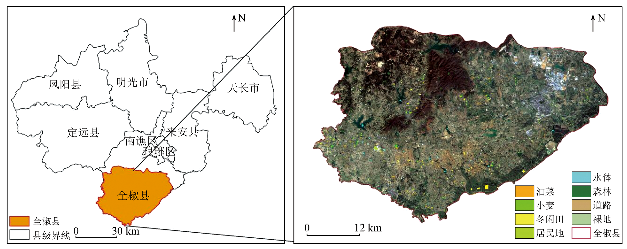
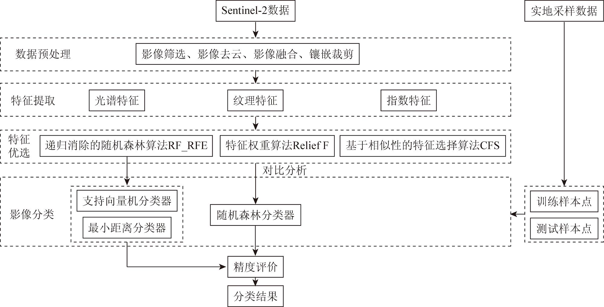
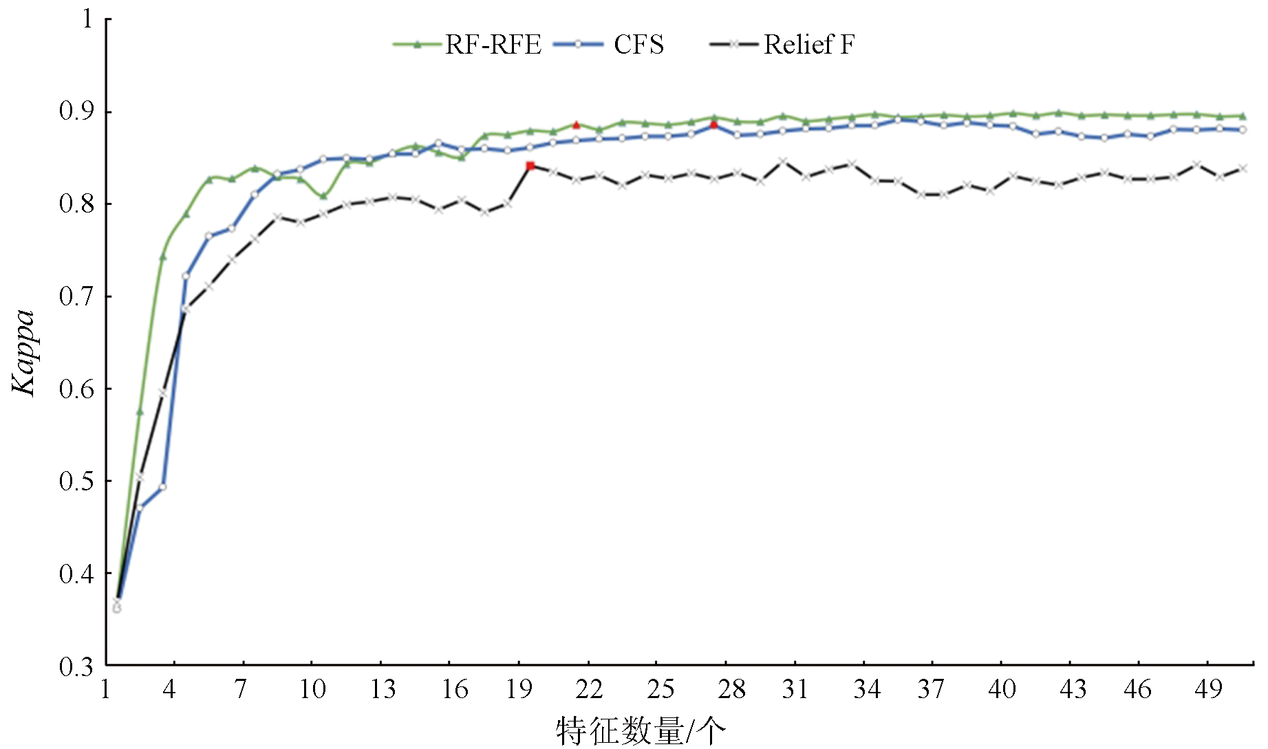
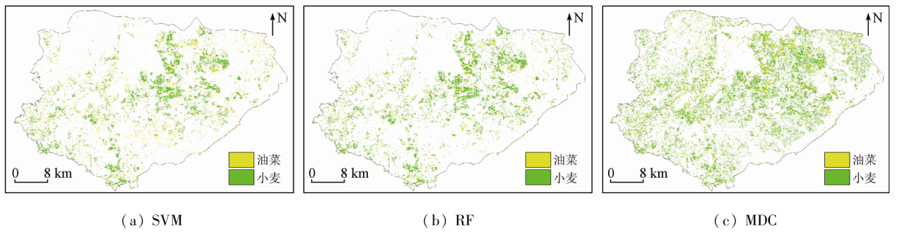
Abstract Focusing on Quanjiao County in Chuzhou City, this study determined 90 features, including spectral, traditional vegetation index, red-edge vegetation index, and texture features, from Sentinel-2 satellite data on the GEE platform. This study examined the effects of diverse feature optimization algorithms combined with a random forest classifier on identifying crop planting types in the study area. These algorithms included the random forest-recursive feature elimination (RF_RFE) algorithm, the Relief F algorithm based on Relief expansion, and the correlation-based feature selection (CFS) algorithm. On this basis, this study further analyzed the classification effects of the optimal feature optimization algorithm in various machine learning classification approaches. The study demonstrates that: ① Spectral features proved to be the most crucial for crop identification, followed by red-edge index features, and texture features manifested minimal effects; ② RF_RFE-based remote sensing identification results exhibited the highest accuracy, with overall accuracy of 92% and a Kappa coefficient of 0.89; ③ Under the RF_RFE feature optimization method, the RF’s Kappa coefficient was 0.01 and 0.41 higher than that of the support vector machine (SVM) and the minimum distance classification (MDC), respectively. This indicates that the RF_RFE feature optimization method based on multiple features, combined with the RF algorithm, can effectively enhance the accuracy and efficiency of remote sensing identification of crops.
|
| Keywords
Google Earth Engine
Sentinel-2
crop identification
feature optimization
random forest
|
|
|
|
Issue Date: 21 December 2023
|
|
|
| [1] |
黄健熙, 武思杰, 刘兴权, 等. 基于遥感信息与作物模型集合卡尔曼滤波同化的区域冬小麦产量预测[J]. 农业工程学报, 2012, 28(4):142-148.
|
| [1] |
Huang J X, Wu S J, Liu X Q, et al. Regional winter wheat yield forecasting based on assimilation of remote sensing data and crop growth model with Ensemble Kalman method[J]. Transactions of the Chinese Society of Agricultural Engineeing, 2012, 28(4):142-148.
|
| [2] |
王利民, 刘佳, 季富华. 中国农业遥感技术应用现状及发展趋势[J]. 中国农学通报, 2021, 37(25):138-143.
doi: 10.11924/j.issn.1000-6850.casb20190700361
|
| [2] |
Wang L M, Liu J, Ji F H. Application status and development trend of agriculture remote sensing technology application in China[J]. Chinese Agricultural Science Bulletin, 2021, 37(25):138-143.
|
| [3] |
贾坤, 李强子. 农作物遥感分类特征变量选择研究现状与展望[J]. 资源科学, 2013, 35(12):2507-2516.
|
| [3] |
Jia K, Li Q Z. Review of features selection in crop classification using remote sensing data[J]. Resources Science, 2013, 35(12):2507-2516.
|
| [4] |
程彬. 基于支持向量机的乾安县土地利用遥感分类研究[J]. 长春师范大学学报, 2017, 36(12):86-88.
|
| [4] |
Cheng B. Land use information extraction based on support vector machine using multitemporal remote sensing in Qian’an County[J]. Journal of Changchun Normal University, 2017, 36(12):86-88.
|
| [5] |
王德军, 姜琦刚, 李远华, 等. 基于Sentinel-2A/B时序数据与随机森林算法的农耕区土地利用分类[J]. 国土资源遥感, 2020, 32(4):236-243.doi:10.6046/gtzyyg.2020.04.29.
|
| [5] |
Wang D J, Jiang Q G, Li Y H, et al. Land use classification of farming areas based on time series Sentinel-2A/B data and random forest algorithm[J]. Remote Sensing of Land and Resources, 2020, 32(4):236-243.doi:10.6046/gtzyyg.2020.04.29.
|
| [6] |
杨欢, 邓帆, 张佳华, 等. 基于MODIS EVI的江汉平原油菜和冬小麦种植信息提取研究[J]. 国土资源遥感, 2020, 32(3):208-215.doi:10.6046/gtzyyg.2020.03.27.
|
| [6] |
Yang H, Deng F, Zhang J H, et al. A study of information extraction of rape and winter wheat planting in Jianghan Plain based on MODIS EVI[J]. Remote Sensing of Land and Resources, 2020, 32(3):208-215.doi:10.6046/gtzyyg.2020.03.27.
|
| [7] |
梁继, 郑镇炜, 夏诗婷, 等. 高分六号红边特征的农作物识别与评估[J]. 遥感学报, 2020, 24(10):1168-1179.
|
| [7] |
Liang J, Zheng Z W, Xia S T, et al. Crop recognition and evaluationusing red edge features of GF-6 satellite[J]. Journal of Remote Sensing, 2020, 24(10):1168-1179.
|
| [8] |
周小成, 郑磊, 黄洪宇. 基于多特征优选的无人机可见光遥感林分类型分类[J]. 林业科学, 2021, 57(6):24-36.
|
| [8] |
Zhou X C, Zheng L, Huang H Y. Classification of forest stand based on multi-feature optimization of UAV visible light remote sensing[J]. Forestry Science, 2021, 57(6):24-36.
|
| [9] |
刘家福, 李林峰, 任春颖, 等. 基于特征优选的随机森林模型的黄河口滨海湿地信息提取研究[J]. 湿地科学, 2018, 16(2):97-105.
|
| [9] |
Liu J F, Li L F, Ren C Y, et al. Information extraction of coastal wetlands in Yellow River Estuary by optimal feature-based random forest model[J]. Journal of Wetland Science, 2018, 16(2):97-105.
|
| [10] |
刘莹, 孟庆岩, 王永吉, 等. 基于特征优选与支持向量机的不透水面覆盖度估算方法[J]. 地理与地理信息科学, 2018, 34(1):24-31,3.
|
| [10] |
Liu Y, Meng Q Y, Wang Y J, et al. A method for estimating impervious surface percentage based on feature optimization and SVM[J]. Geography and Geoinformatics Science, 2018, 34(1):24-31,3.
|
| [11] |
张东彦, 杨玉莹, 黄林生, 等. 结合Sentinel-2影像和特征优选模型提取大豆种植区[J]. 农业工程学报, 2021, 37(9):110-119.
|
| [11] |
Zhang D Y, Yang Y Y, Huang L S, et al. Extraction of soybean planting areas combining Sentinel-2 images and optimized feature model[J]. Transactions of the Chinese Society of Agricultural Engineering, 2021, 37(9):110-119.
|
| [12] |
张文博, 孔金玲, 杨园园, 等. 面向对象的旱区植被遥感精细分类研究[J]. 测绘科学, 2021, 46(1):136-140,183.
|
| [12] |
Zhang W B, Kong J L, Yang Y Y, et al. Fine vegetation classification of remote sensing in arid areas based on object-oriented method[J]. Science of Surveying and Mapping, 2021, 46(1):136-140,183.
|
| [13] |
Ni R, Tian J, Li X, et al. An enhanced pixel-based phenological feature for accurate paddy rice mapping with Sentinel-2 imagery in Google Earth Engine[J]. ISPRS Journal of Photogrammetry and Remote Sensing, 2021,178,282-296.
|
| [14] |
王李娟, 孔钰如, 杨小冬, 等. 基于特征优选随机森林算法的农耕区土地利用分类[J]. 农业工程学报, 2020, 36(4):244-250.
|
| [14] |
Wang L J, Kong Y R, Yang X D, et al. Classification of land use in farming areas based on feature optimization random forest algorithm[J]. Transactions of the Chinese Society of Agricultural Engineering, 2020, 36(4):244-250.
|
| [15] |
熊皓丽, 周小成, 汪小钦, 等. 基于GEE云平台的福建省10 m茶园专题空间分布制图[J]. 地球信息科学学报, 2021, 23(7):1325-1337.
|
| [15] |
Xiong H L, Zhou X C, Wang X Q, et al. Mapping the spatial distribution of tea plantations with 10 m resolution in Fujian Province using google earth engine[J]. Journal of Geoinformatics Science, 2021, 23(7):1325-1337.
|
| [16] |
张磊, 宫兆宁, 王启为, 等. Sentinel-2影像多特征优选的黄河三角洲湿地信息提取[J]. 遥感学报, 2019, 23(2):313-326.
|
| [16] |
Zhang L, Gong Z N, Wang Q W, et al. Wetland mapping of Yellow River Delta wetlands based on multi-feature optimization of Sentinel-2 images[J]. Journal of Remote Sensing, 2019, 23(2):313-326.
|
| [17] |
Haralick R M, Shanmugam K, Dinstiein I H. Textural features for image classification[J]. IEEE Transactions on Systems,Man,and Cybernetics, 1973, 3(6):610-621.
|
| [18] |
王庚泽, 靳海亮, 顾晓鹤, 等. 基于改进分离阈值特征优选的秋季作物遥感分类[J]. 农业机械学报, 2021, 52(2):199-210.
|
| [18] |
Wang G Z, Jin H L, Gu X H, et al. Remote sensing classification of autumn crops based on hybrid feature selection model combining with relief F and improved separability and thresholds[J]. Transactions of the Chinese Society for Agricultural Machinery, 2021, 52(2):199-210.
|
| [19] |
高国龙, 杜华强, 韩凝, 等. 基于特征优选的面向对象毛竹林分布信息提取[J]. 林业科学, 2016, 52(9):77-85.
|
| [19] |
Gao G L, Du H Q, Han N, et al. Mapping of moso bamboo forest using object-based approach based on the optimal features[J]. Forestry Sciences, 2016, 52(9):77-85.
|
| [20] |
Millard K, Richardson M. On the importance of training data sample selection in random forest image classification:A case study in peatland ecosystem mapping[J]. Remote Sensing, 2015, 7(7):8489-8515.
doi: 10.3390/rs70708489
url: http://www.mdpi.com/2072-4292/7/7/8489
|
|
Viewed |
|
|
|
Full text
|
|
|
|
|
Abstract
|
|
|
|
|
Cited |
|
|
|
|
| |
Shared |
|
|
|
|
| |
Discussed |
|
|
|
|
 2023,
Vol. 35
2023,
Vol. 35