|
|
 |
|
|
|
|
Monitoring of inter-annual variations in mangrove forests in the Bamen Bay area based on Google Earth Engine |
XUE Zhiyong( ), TIAN Zhen, ZHU Jianhua, ZHAO Yang ), TIAN Zhen, ZHU Jianhua, ZHAO Yang |
| National Marine Technology Center, Tianjin 300112, China |
|
|
|
|
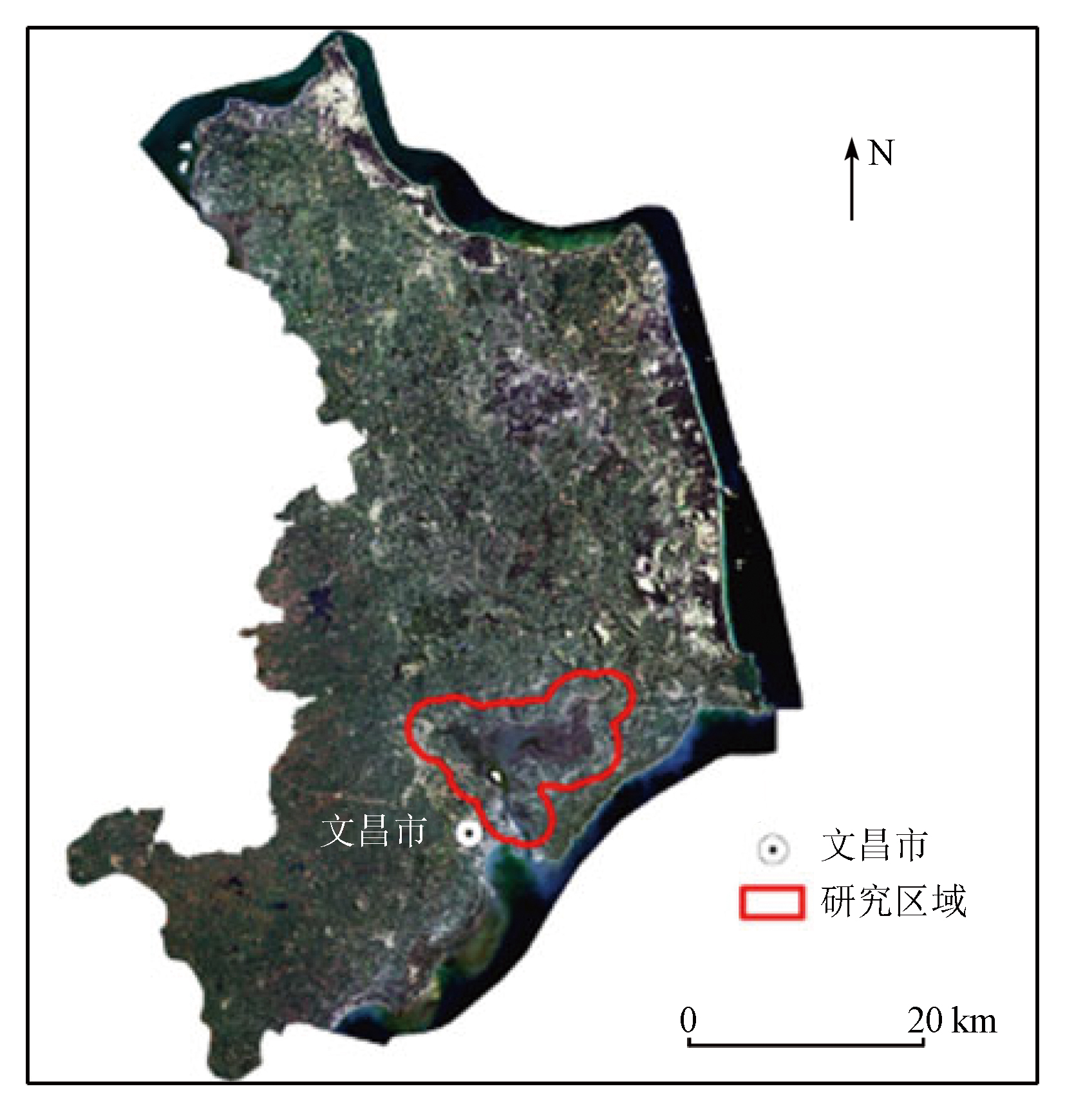
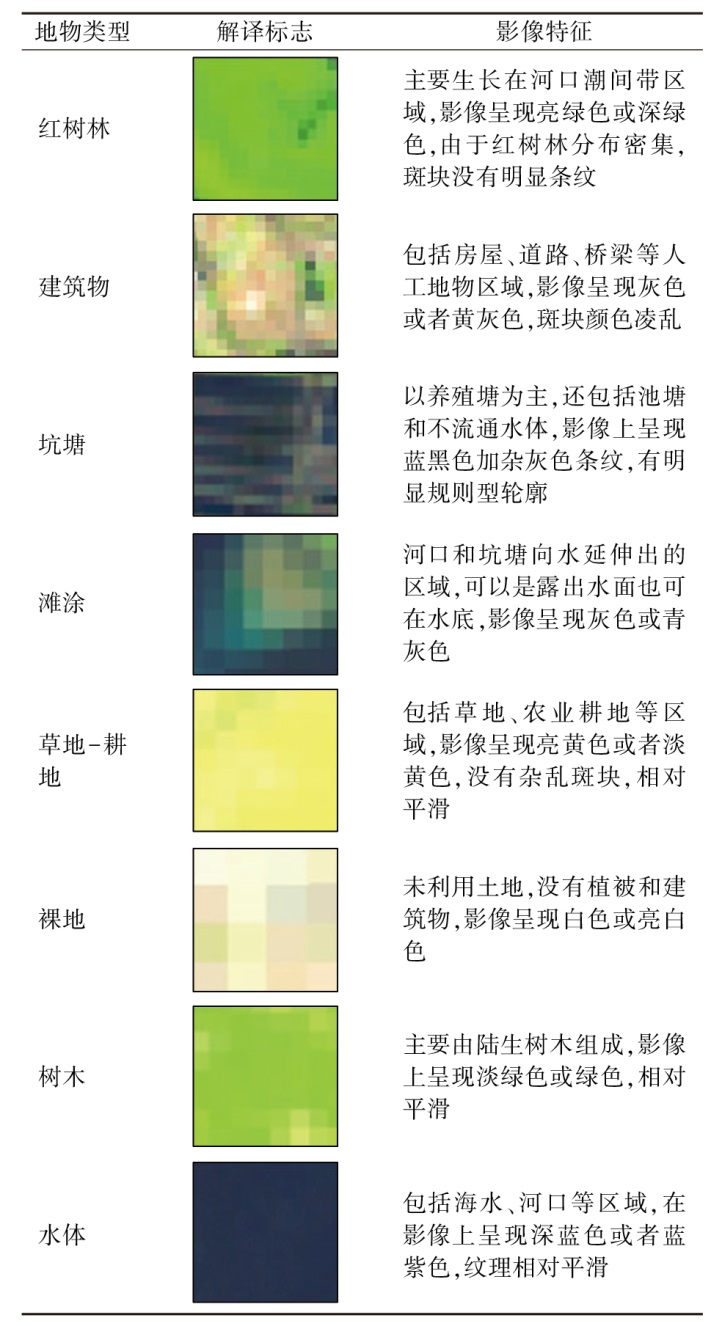
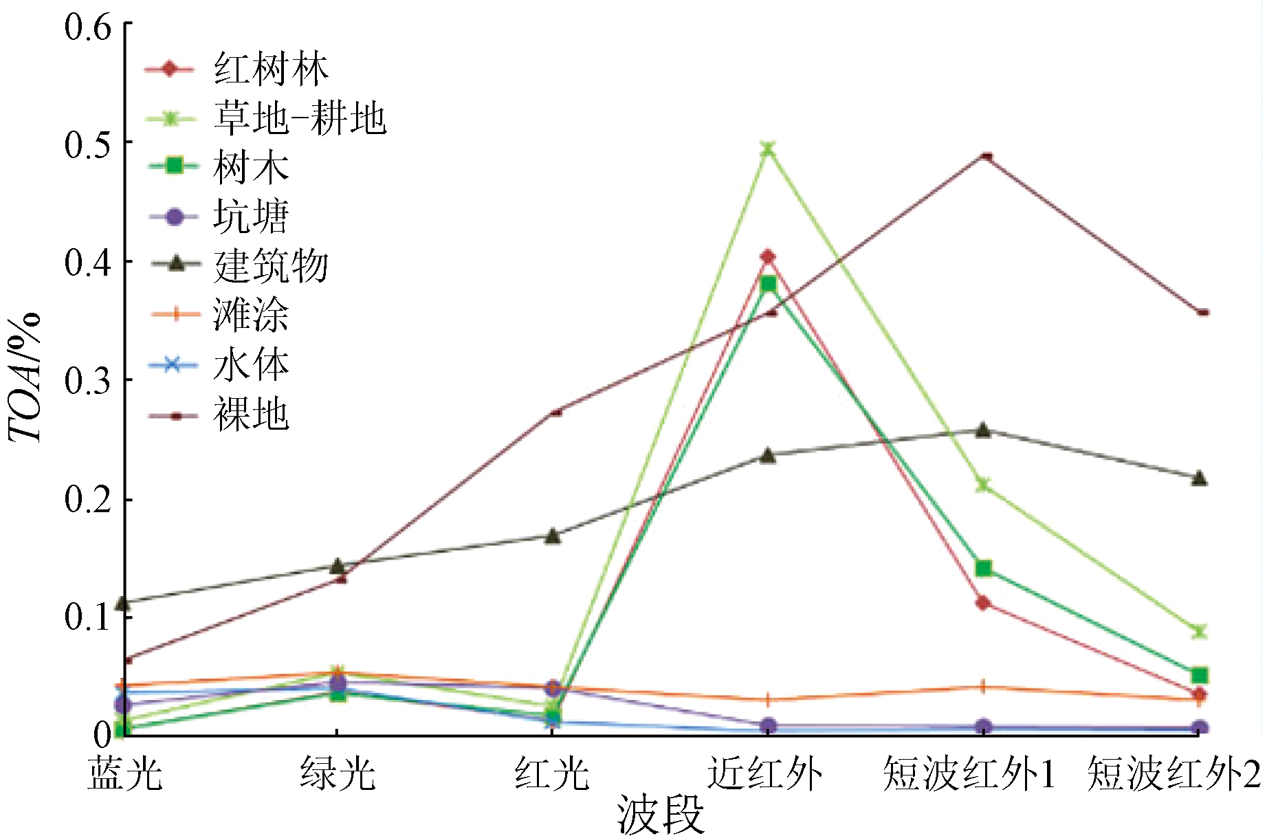
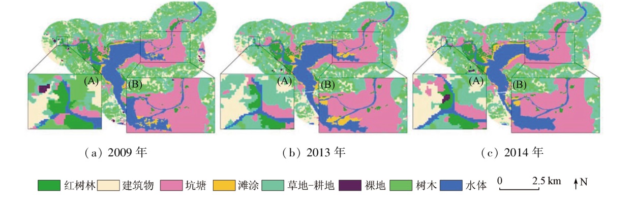
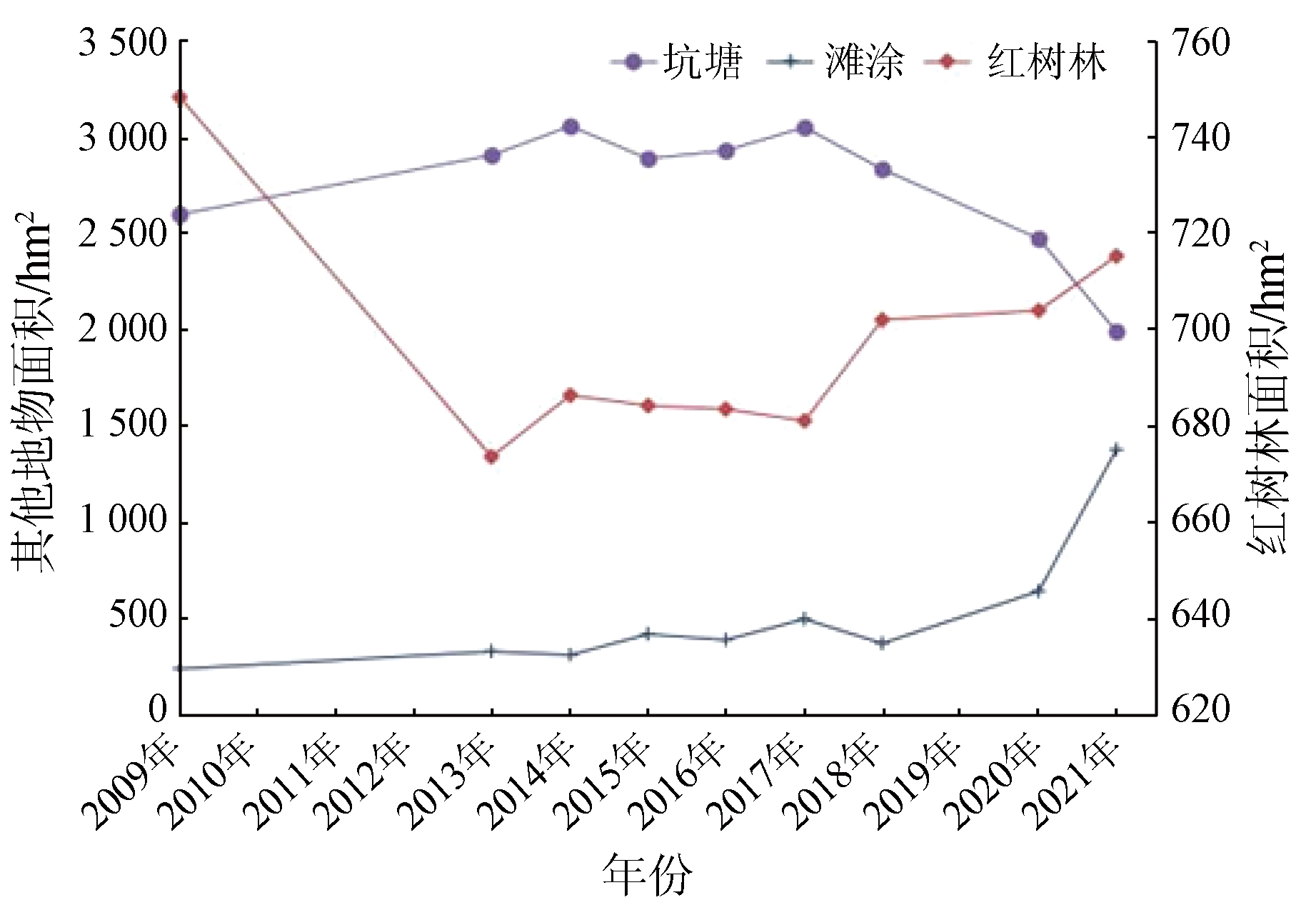
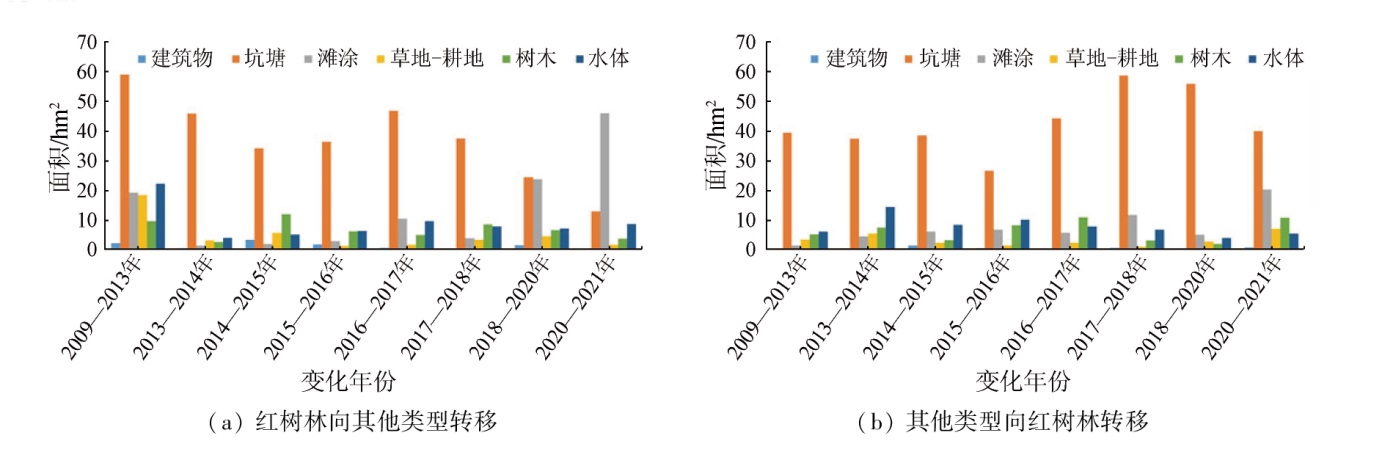
Abstract Based on the Google Earth Engine (GEE) cloud platform and Landsat series data, this study classified the surface features of the Bamen Bay area using the support vector machine (SVM) classification method. Furthermore, the classification results were employed to monitor the inter-annual variations of mangrove forests in the area. The analysis reveals that mangrove forests and terrestrial trees exhibit extraordinarily similar reflectance spectral curves except for infrared bands. Hence, they were effectively distinguished using the infrared band feature index and topographic data, achieving an overall classification accuracy of 91%. The classification results show that mangrove forests in the study area manifested a trend of decrease followed by increase. Specifically, they decreased from 2009 to 2013, remained almost unchanged from 2014 to 2016, and increased slowly from 2017 to 2021. The increase in mangrove forests and the decrease in pits and ponds occurred following the wetland restoration policy that requires planting mangrove forests in South China and tamarix chinensis in North China, suggesting remarkable effects of the policy for returning ponds to forests. The transfer matrix analysis reveals a mutual transfer between mangrove forests and pits, ponds, suggesting that deforesting for ponds and returning ponds to forests constitute the primary factors influencing the variations in mangrove forests. The inter-annual variation monitoring results of mangrove forests enable detailed analysis of the evolutionary process of mangrove forests and accurate quantification of the transformation between mangrove forests and other land types. Therefore, the factors influencing mangrove forest evolution can be analyzed from the perspective of economy and policy for more effective preservation of mangrove forests.
|
| Keywords
mangrove forest
Google Earth Engine
inter-annual variation monitoring
Bamen Bay
|
|
|
|
Issue Date: 14 June 2024
|
|
|
| [1] |
蓝宗辉, 詹嘉红, 杜联穆. 红树林及其在海洋生态中的作用[J]. 韩山师范学院学报, 2002(2):63-67.
|
| [1] |
Lan Z H, Zhan J H, Du L M. Mangrove and its effects on ocean ecosystem[J]. Journal of Hanshan Teachers College, 2002(2):63-67.
|
| [2] |
Thomas N, Lucas R, Bunting P, et al. Distribution and drivers of global mangrove forest change,1996—2010[J]. PLoS ONE, 2017, 12(6):e0179302.
|
| [3] |
Blasco F, Aizpuru M, Gers C. Depletion of the mangroves of continental Asia[J]. Wetlands Ecology and Management, 2001, 9(3):255-266.
|
| [4] |
莫燕妮, 庚志忠, 王春晓. 海南岛红树林资源现状及保护对策[J]. 热带林业, 2002(1):46-50.
|
| [4] |
Mo Y N, Geng Z Z, Wang C X. Status of mangrove resources in Hainan Island and its conservation measures[J]. Tropical Forestry, 2002(1):46-50.
|
| [5] |
黄小兰, 张婷, 谭人纲. 海南红树林资源现状与预警研究[J]. 江西师范大学学报(自然科学版), 2018, 42(3):236-241.
|
| [5] |
Huang X L, Zhang T, Tan R G. The studies on current status and pre-warning mechanism of mangroves in Hainan[J]. Journal of Jiangxi Normal University(Natural Science), 2018, 42(3):236-241.
|
| [6] |
何海军, 温家声, 张锦炜, 等. 海南红树林湿地生态系统服务价值评估[J]. 生态经济, 2015, 31(4):145-149.
|
| [6] |
He H J, Wen J S, Zhang J Y, et al. Ecological functions assessment of mangrove wetland in Hainan Province[J]. Ecological Economy, 2015, 31(4):145-149.
|
| [7] |
李超. 浅谈文昌市清澜港红树林湿地生态系统存在问题和发展对策[J]. 热带林业, 2010, 38(4):4-6.
|
| [7] |
Li C. Discussion on the existing problems and development countermeasures of mangroves wetland ecosystem in Qinglangang,Wenchang[J]. Tropical Forestry, 2010, 38(4):4-6.
|
| [8] |
李儒, 朱博勤, 童晓伟, 等. 2002—2013年海南东寨港自然保护区湿地变化分析[J]. 国土资源遥感, 2017, 29(3):149-155.doi:10.6046/gtzyyg.2017.03.22.
|
| [8] |
LI R, Zhu B Q, Tong X W, et al. Change analysis in Hainan Dongzhai Wetland Reserve based on remote sensing data obtained during 2002—2013[J]. Remote Sensing for Land and Resources, 2017, 29(3):149-155.doi:10.6046/gtzyyg.2017.03.22.
|
| [9] |
Mohd R S, Radzi M A, Marin A, et al. A bibliometric analysis of tropical mangrove forest land use change from 2010 to 2020[J]. Environment,Development and Sustainability, 2022, 24:11530-11547.
|
| [10] |
Maurya K, Mahajan S, Chaube N. Remote sensing techniques:Mapping and monitoring of mangrove ecosystem:A review[J]. Complex & Intelligent Systems, 2021, 7(6):2797-2818.
|
| [11] |
Gopalakrishnan L, Satyanarayana B, Chen D, et al. Using Historical archives and Landsat imagery to explore changes in the mangrove cover of Peninsular Malaysia between 1853 and 2018[J]. Remote Sensing, 2021, 13(17):3403-3403.
|
| [12] |
Rahman M S, Ibrahim M, Hasan M, et al. Spatio-temporal analysis of land use and land cover changes in Barguna District of Bangladesh using remote sensing techniques:Focusing on mangrove vegetation[J]. Journal of Global Ecology and Environment, 2021, 11(4):43-54.
|
| [13] |
马云梅, 吴培强, 任广波. 基于高分影像光谱特征的广西海岸带红树林精细分类与制图[J]. 地球信息科学学报, 2021, 23(12):2292-2304.
doi: 10.12082/dqxxkx.2021.210494
|
| [13] |
Ma Y M, Wu P Q, Ren G B. Fine classification and mapping of mangroves in Guangxi coastal zone based on spectral characteristics of GF images[J]. Journal of Geo-Information Science, 2021, 23(12):2292-2304.
|
| [14] |
徐晓然, 谢跟踪, 邱彭华. 1964—2015年海南省八门湾红树林湿地及其周边土地景观动态分析[J]. 生态学报, 2018, 38(20):7458-7468.
|
| [14] |
Xu X R, Xie G Z, Qiu P H. Dynamic analysis of landscape changes in Bamen port and the surrounding lands of Hainan Province from 1964 to 2015[J]. Acta Ecologica Sinica, 2018, 38(20):7458-7468.
|
| [15] |
Moore R T, Hansen M C. Google Earth Engine:A new cloud-computing platform for global-scale earth observation data and analysis[C]// AGU Fall Meeting Abstracts, 2011:IN43C-02.
|
| [16] |
Hansen M C, Potapov P V, Moore R T, et al. High-resolution global maps of 21st-century forest cover change[J]. Science, 2013, 342(6160):850-853.
doi: 10.1126/science.1244693
pmid: 24233722
|
| [17] |
Chen B, Xiao X, Li X, et al. A mangrove forest map of China in 2015:Analysis of time series Landsat7/8 and Sentinel-1A imagery in Google Earth Engine cloud computing platform[J]. ISPRS Journal of Photogrammetry Remote Sensing, 2017, 131:104-120.
|
| [18] |
薛朝辉, 钱思羽. 融合Landsat8与Sentinel-2数据的红树林物候信息提取与分类研究[J]. 遥感学报, 2022, 26(6):1121-1142.
|
| [18] |
Xue Z H, Qian S Y. Fusion of Landsat8 and Sentinel-2 data for mangrove phenology information extraction and classification[J]. National Remote Sensing Bulletin, 2022, 26(6):1121-1142.
|
| [19] |
刘凯, 彭力恒, 李想, 等. 基于Google Earth Engine的红树林年际变化监测研究[J]. 地球信息科学学报, 2019, 21(5):731-739.
doi: 10.12082/dqxxkx.2019.180354
|
| [19] |
Peng L H, Li X, et al. Monitoring the inter-annual change of mangrove based on the Google Earth Engine[J]. Journal of Geo-Information Science, 2019, 21(5):731-739.
|
| [20] |
张雪红, 田庆久. 利用温湿度指数提高红树林遥感识别精度[J]. 国土资源遥感, 2012, 24(3):65-70.doi:10.6046/gtzyyg.2012.03.13.
|
| [20] |
Zhang X H, Tian Q J. Application of the temperature-moisture index to the improvement of remote sensing identification accuracy of mangrove[J]. Remote Sensing for Land and Resources, 2012, 24(3):65-70.doi:10.6046/gtzyyg.2012.03.13.
|
| [21] |
张雪红. 基于决策树方法的Landsat8 OLI影像红树林信息自动提取[J]. 国土资源遥感, 2016, 28(2):182-187.doi:10.6046/gtzyyg.2016.02.28.
|
| [21] |
Zhang X. Decision tree algorithm of automatically extracting mangrove forests information from Landsat8 OLI imagery[J]. Remote Sensing for Land and Resources, 2016, 28(2):182-187.doi:10.6046/gtzyyg.2016.02.28.
|
| [22] |
Jensen J R, Lin H, Yang X, et al. The measurement of mangrove characteristics in southwest Florida using SPOT multispectral data[J]. Geocarto International, 1991, 6(2):13-21.
|
| [23] |
Cristianini N, Shawe-Taylor J. An introduction to support vector machines and other kernel-based learning methods[M]. Cambridge: Cambridge University Press, 2000.
|
| [24] |
刘瑞, 朱道林. 基于转移矩阵的土地利用变化信息挖掘方法探讨[J]. 资源科学, 2010, 32(8):1544-1550.
|
| [24] |
Liu R, Zhu D L. Methods for detecting land use changes based on the land use transition matrix[J]. Resources Science, 2010, 32(8):1544-1550.
|
|
Viewed |
|
|
|
Full text
|
|
|
|
|
Abstract
|
|
|
|
|
Cited |
|
|
|
|
| |
Shared |
|
|
|
|
| |
Discussed |
|
|
|
|
 2024,
Vol. 36
2024,
Vol. 36