|
|
 |
|

|
|
|
Multi-model estimation of forest leaf area index in the Three Gorges Reservoir area |
| Lixin DONG1,2,3 |
1.Key Laboratory of Radiometric Calibration and Validation for Environmental Satellites, Beijing 100081, China
2.National Satellites Meteorological Center, Beijing 100081, China
3.The Joint Center for Satellite Research and Applications, Chinese Academy of Meteorological Sciences, Beijing 100081, China |
|
|
|
|
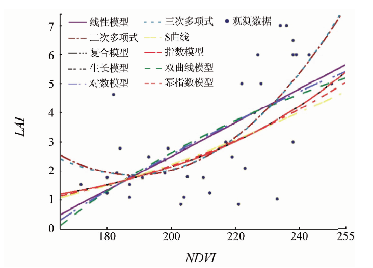
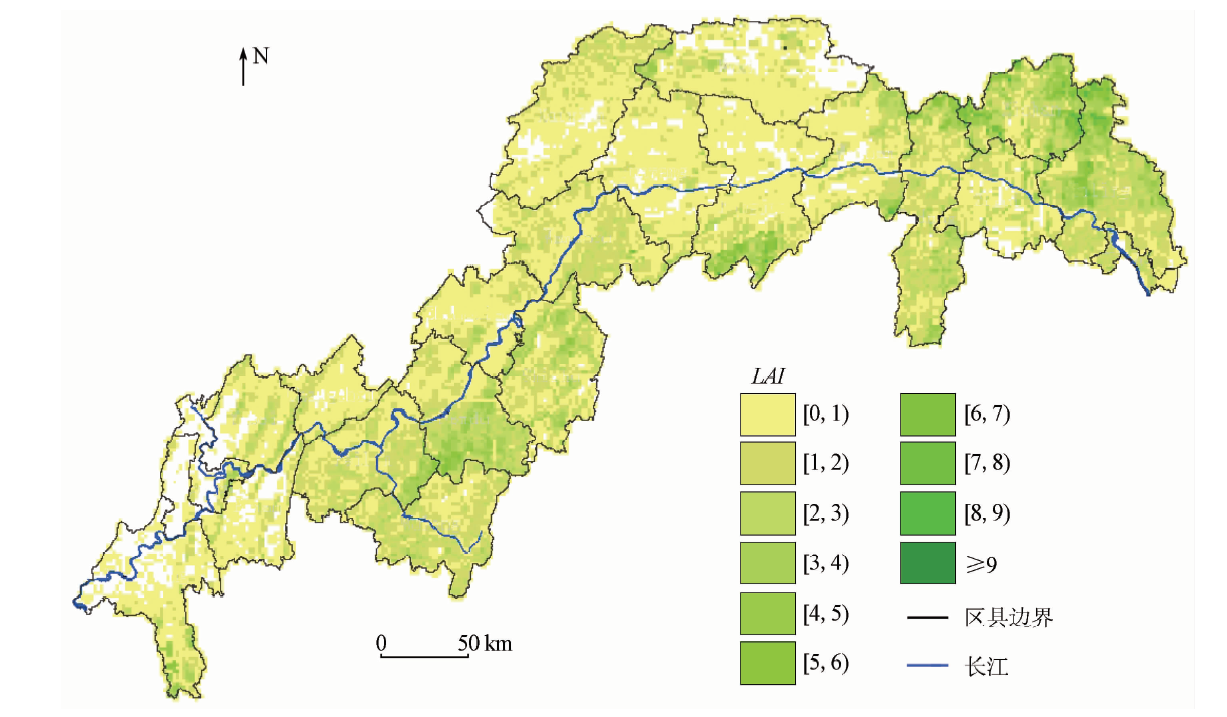
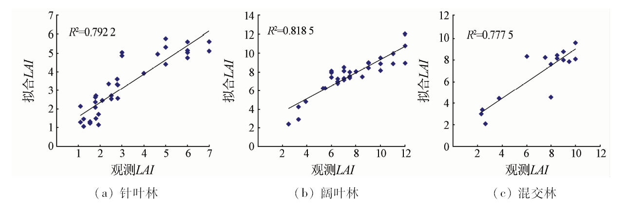
Abstract Leaf area index (LAI) is an important structural variable for quantitative study of the energy exchange characteristics of forest ecosystems. Based on field observations of LAI, 7 kinds of vegetation indexes and 5 custom vegetation indexes based on Landsat TM, LAI estimation model of different forest types were established through the model screening, in which the multiple regression model for coniferous forest and principal component analysis model for broad-leaved forest and mixed forest were used. Finally, the regional scale forest LAI distribution map was made through multiple model estimation. The accuracy of LAI is 0.829 4, 1.111 5 and 1.790 9 for coniferous forest, broad-leaved forest and mixed forest respectively. And the total R 2 is over 0.77 for all the forests. The results will provide basic data for forest ecosystem and carbon cycle studies.
|
| Keywords
forest leaf area index
vegetation index method
principal component analysis
Three Gorges Reservoir area
remote sensing
|
|
|
|
Issue Date: 23 May 2019
|
|
|
| [1] |
Chen J M, Black T A . Foliage area and architecture of clumped plant canopies from sunfleck size distributions[J]. Agricultural and Forest Meteorology, 1992,60(3-4):249-266.
doi: 10.1016/0168-1923(92)90040-B
url: https://linkinghub.elsevier.com/retrieve/pii/016819239290040B
|
| [2] |
Gower S T, Kucharik C J, Norman J M . Direct and indirect estimation of leaf area index,FAPAR,and net primary production of terrestrial ecosystems[J]. Remote Sensing of Environment, 1999,70(1):29-51.
doi: 10.1016/S0034-4257(99)00056-5
url: https://linkinghub.elsevier.com/retrieve/pii/S0034425799000565
|
| [3] |
Chen J, Cihlar J . Retrieving leaf area index of Boreal Conifer Forest using Landsat TM images[J]. Remote Sensing of Environment, 1996,55:153-162.
doi: 10.1016/0034-4257(95)00195-6
url: https://linkinghub.elsevier.com/retrieve/pii/0034425795001956
|
| [4] |
Geol N S, Rozehnal I . A High-level Language for L-systems and Its Application[M]. New York:Springer-Verlag, 1992: 231-251.
|
| [5] |
Chen X X, Vierling L, Rowell E . Using LiDAR and effective LAI data to evaluate IKONOS and Landsat7 ETM+ vegetation cover estimates in a ponderosa pine forest[J]. Remote Sensing of Environment, 2004,91(1):14-26.
doi: 10.1016/j.rse.2003.11.003
url: https://linkinghub.elsevier.com/retrieve/pii/S0034425703003419
|
| [6] |
朱高龙, 居为民, 范文义 , 等. 帽儿山地区森林冠层叶面积指数的地面观测与遥感反演[J]. 应用生态学报, 2010,21(8):2127-2124.
|
| [6] |
Zhu G L, Ju W M, Fan W Y , et al. Forest canopy leaf area index in Maoershan Mountain:Ground measurement and remote sensing retrieval[J]. Chinese Journal of Applied Ecology, 2010,21(8):2127-2124.
|
| [7] |
刘婧怡, 汤旭光, 常守志 , 等. 森林叶面积指数遥感反演模型构建及区域估算[J]. 遥感技术与应用, 2014,29(1):18-25.
doi: doi:10.11873/j.issn.1004\|0323.2014.1.0018
|
| [7] |
Liu J Y, Tang X G, Chang S Z , et al. Application of remote sensing to inverse the forest leaf area index and regional estimation[J]. Remote Sensing Technology and Application, 2014,29(1):18-25.
|
| [8] |
韩婷婷, 习晓环, 王成 , 等. 基于TM数据的西双版纳地区森林叶面积指数反演[J]. 遥感信息, 2014,29(2):28-32.
|
| [8] |
Han T T, Xi X H, Wang C , et al. Forest leaf area index inversion based on TM data in Xishuangbanna Area[J]. Remote Sensing Information, 2014,29(2):28-32.
|
| [9] |
刘振波, 刘杰 . 森林冠层叶面积指数遥感反演——以小兴安岭五营林区为例[J]. 生态学杂志, 2015,34(7):1930-1936.
|
| [9] |
Liu Z B, Liu J . Retrieving forest canopy LAI from remote sensing data:A case study over Wuying forest in the Lesser Khingan[J]. Chinese Journal of Ecology, 2015,34(7):1930-1936.
|
| [10] |
姚雄, 余坤勇, 杨玉洁 , 等. 基于随机森林模型的林地叶面积指数遥感估算[J]. 农业机械学报, 2017,48(5):159-166.
|
| [10] |
Yao X, Yu K Y, Yang Y J , et al. Estimation of forest leaf area index based on random forest model and remote sensing data[J]. Transactions of the Chinese Society for Agricultural Machinery, 2017,48(5):159-166.
|
| [11] |
张瀛, 孟庆岩, 武佳丽 , 等. 基于环境星CCD数据的环境植被指数及叶面积指数反演研究[J]. 光谱学与光谱分析, 2011,31(10):2789-2793.
url: http://www.opticsjournal.net/Articles/Abstract?aid=OJ111109000207JfMiPl
|
| [11] |
Zhang Y, Meng Q Y, Wu J L , et al. Study of environmental vegetation index based on environment satellite CCD data and LAI inversion[J]. Spectroscopy and Spectral Analysis, 2011,31(10):2789-2793.
|
| [12] |
Colombo R, Bellingeri D, Fasolini D , et al. Retrieval of leaf index in different vegetation types using high resolution satellite data[J]. Remote Sensing Environment, 2003,86:120-131.
doi: 10.1016/S0034-4257(03)00094-4
url: https://linkinghub.elsevier.com/retrieve/pii/S0034425703000944
|
| [13] |
Fensholt R . Earth observation of vegetation status in the Sahelian and Sudanian Weat Africa:Comparison of Terra MODIS and NOAA AVHRR satellite data[J]. International Journal of Remote Sensing, 2004,25(9):1641-1659.
doi: 10.1080/01431160310001598999
url: https://www.tandfonline.com/doi/full/10.1080/01431160310001598999
|
| [14] |
Pu R L, Gong P . Wavelet transform applied to EO-1 hyperspectral data for forest LAI and crown closure mapping[J]. Remote Sensing of Environment, 2004,91:212-224.
doi: 10.1016/j.rse.2004.03.006
url: https://linkinghub.elsevier.com/retrieve/pii/S0034425704000811
|
| [15] |
Vaesen K, Gilliams S, Nackaerets K , et al. Ground-measured spectral signatures as indicators of ground cover and leaf area index:The case of paddy rice[J]. Field Crops Research, 2001,69(1):13-25.
doi: 10.1016/S0378-4290(00)00129-5
url: https://linkinghub.elsevier.com/retrieve/pii/S0378429000001295
|
| [16] |
Franklin S E, Lavigne M B, Deuling M J , et al. Estimation of forest leaf area index using remote sensing and GIS data for modeling net primary production[J]. International Journal of Remote Sensing, 1997,18(16):3459-3471.
doi: 10.1080/014311697216973
url: https://www.tandfonline.com/doi/full/10.1080/014311697216973
|
| [17] |
Kuusk A . Monitoring of vegetation parameters on large areas by the inversion of a canopy reflectance model[J]. International Journal of Remote Sensing, 1998,19(15):2893-2905.
doi: 10.1080/014311698214334
url: https://www.tandfonline.com/doi/full/10.1080/014311698214334
|
| [18] |
陈丽, 张晓丽, 焦志敏 . 基于混合像元分解模型的森林叶面积指数反演[J]. 农业工程学报, 2013,29(13):124-129.
|
| [18] |
Chen L, Zhang X L, Jiao Z M . Reversion of leaf area index in forest based on linear mixture model[J]. Transactions of the Chinese Society of Agricultural Engineering, 2013,29(13):124-129.
|
| [19] |
Suits G H . The calculation of the directional reflectance of vevetative canopy[J]. Remote Sensing of Environment, 1972,2:117-125.
|
| [20] |
Kuusk A . The hot spot effect of a uniform vegetative cover[J]. Soviet Journal of Remote Sensing, 1985,3:645-658.
|
| [21] |
Li X W, Strahler A H .Geometric-optical modeling of conifer forest canopy[J].IEEE Transactions on Geoscience and Remote Sensing, 1985, GE-23(5):705-721.
doi: 10.1109/TGRS.1985.289389
url: http://ieeexplore.ieee.org/document/4072365/
|
| [22] |
Li X W, Strahler A H . Geometric-optical bidirectional reflectance modeling of a coniferous forest canopy[J]. IEEE Transactions on Geoscience and Remote Sensing, 1986,24(6):906-919.
|
| [23] |
Jupp D L B, Walker J, Penridge L K . Interpretation of vegetation structure in Landsat MSS imagery:A case study in disturbed semi-aric eucalypt woodland.Part2. Model-based analysis[J]. Journal of Environmental Management, 1986,23:35-57.
|
| [24] |
Li X W, Strahler A H . Geometric-optical bidirectional reflectance modeling of the discrete-crown vegetation canopy:Effect of crown shape and mutual shadowing[J]. IEEE Transactions on Geoscience and Remote Sensing, 1992,30(2):276-292.
doi: 10.1109/36.134078
url: http://ieeexplore.ieee.org/document/134078/
|
| [25] |
Li X W, Strahler A H . Modeling the gap probability of a discontinuous vegetation canopy[J]. IEEE Transactions on Geoscience and Remote Sensing, 1988,26(2):161-170.
doi: 10.1109/36.3017
url: http://ieeexplore.ieee.org/document/3017/
|
| [26] |
Li X W, Strahler A H, Woodcock C E . A hybrid geometric optical-radiative transfer approach for modeling albedo and directional reflectance of discontinuous canopies[J]. IEEE Transactions on Geoscience and Remote Sensing, 1995,33(2):466-480.
doi: 10.1109/36.377947
url: http://ieeexplore.ieee.org/document/377947/
|
| [27] |
吴富祯 . 测树学[M]. 北京: 中国林业出版社, 1992.
|
| [27] |
Wu F Z. Tree Measuring[M]. Beijing: China Forestry Publishing House, 1992.
|
| [28] |
冯宗炜, 王效科, 吴刚 . 中国森林生态系统的生物量和生产力[M]. 北京: 科学出版社, 1999.
|
| [28] |
Feng Z W, Wang X K, Wu G. Biomass and Productivity of Forest Ecosystems in China[M]. Beijing: Science Press, 1999.
|
| [29] |
Hodgson M E, Shelley B M . Removing the topographic effect in remotely sensed imagery[J]. ERDAS Monitor, 1994,6:4-6.
|
| [30] |
张磊, 董立新, 吴炳方 , 等. 三峡水库建设前后库区10年土地覆盖变化[J]. 长江流域资源与环境, 2007,16(1):107-112.
|
| [30] |
Zhang L, Dong L X, Wu B F , et al. Land cover change before and after the construction of Three Gorges Reservoir within 10 years[J]. Resources and Environment in the Yangtze Basin, 2007,16(1):107-112.
|
| [31] |
董立新, 吴炳方, 郭振华 , 等. 三峡库区农林用地变化遥感监测及模拟预测[J]. 农业工程学报, 2009,25(s2):290-297.
|
| [31] |
Dong L X, Wu B F, Guo Z H , et al. Remote sensing monitoring and simulation prediction of agricultural and forestry land use in Three Gorges Reservoir area[J]. Transactions of the Chinese Society of Agricultural Engineering, 2009,25(s2):290-297.
|
| [32] |
陈述彭, 童庆禧, 郭华东 , 等. 遥感信息机理研究[M]. 北京: 科学出版社, 1998.
|
| [32] |
Chen S P, Tong Q X, Guo H D , et al. Research on the Mechanism of Remote Sensing Information[M]. Beijing: Science Press, 1998.
|
| [33] |
Duncan J , Stow JD A V,Franklin JJ ,et al..Assessing the relationship between spectral vegetation indices and shrub cover in the Jornada Basin,New Mexico[J]. International Journal of Remote Sensing, 1993,14(18):3395-3416.
doi: 10.1080/01431169308904454
url: https://www.tandfonline.com/doi/full/10.1080/01431169308904454
|
| [34] |
Rouse J W, Haas R W, Schell J A , et al. Monitoring the Vernal Advancement and Retrogradation (Green Wave Effect) of Natural Vegetation[R]. Greenbelt:NASA, 1974.
|
| [35] |
Richardson A J, Wiegand C L . Distinguishing vegetation from soil background information[J]. Photogrammetric Engineering and Remote Sensing, 1977,43(12):1541-1552.
|
| [36] |
Huete A R . A soil-adjusted vegetation index (SAVI)[J]. Remote Sensing of Environment, 1988,25(3):295-309.
doi: 10.1016/0034-4257(88)90106-X
url: https://linkinghub.elsevier.com/retrieve/pii/003442578890106X
|
| [37] |
Purevdor J T S, Tateishi R, Ishiyama T , et al. Relationships between percent vegetation cover and vegetation indices[J]. International Journal of Remote Sensing, 1998,19(18):3519-3535.
doi: 10.1080/014311698213795
url: https://www.tandfonline.com/doi/full/10.1080/014311698213795
|
| [38] |
Clevers J G P W . The application of a weighted infrared-red vegetation index for estimating leaf area index by correcting for soil-background[J]. Remote Sensing of Environment, 1989,29:25-37.
doi: 10.1016/0034-4257(89)90076-X
url: https://linkinghub.elsevier.com/retrieve/pii/003442578990076X
|
| [39] |
Kaufman Y J, Tanre D . Atmospherically resistant vegetation index (ARVI) for EOS MODIS[J]. IEEE Transactions Geoscience and Remote Sensing, 1992,30(2):261-270.
doi: 10.1109/36.134076
url: http://ieeexplore.ieee.org/document/134076/
|
| [40] |
Pu R L, Gong P. Hyperspectral Remote Sensing and Its Application[M]. Beijing: Higher Education Press, 2000.
|
|
Viewed |
|
|
|
Full text
|
|
|
|
|
Abstract
|
|
|
|
|
Cited |
|
|
|
|
| |
Shared |
|
|
|
|
| |
Discussed |
|
|
|
|
 2019,
Vol. 31
2019,
Vol. 31