|
|
 |
|

|
|
|
Analysis of high-frequency spatiotemporal evolution of patches reflecting 2020—2023 changes in coastal areas of the Chinese mainland |
LI Wei1,2( ), ZHAO Binru1, LIANG Jianfeng1(), ZHOU Peng2, ZHANG Feng1 ), ZHAO Binru1, LIANG Jianfeng1(), ZHOU Peng2, ZHANG Feng1 |
1. National Marine Data and Information Service, Tianjin 300012, China
2. College of Oceanography and Space Informatics, China University of Petroleum, Qingdao 266580, China |
|
|
|
|
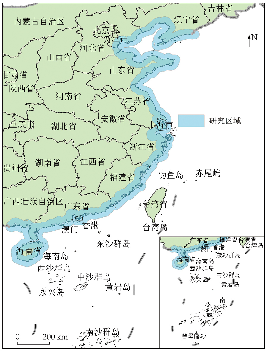
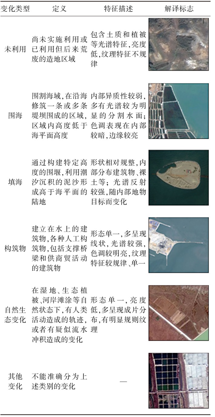
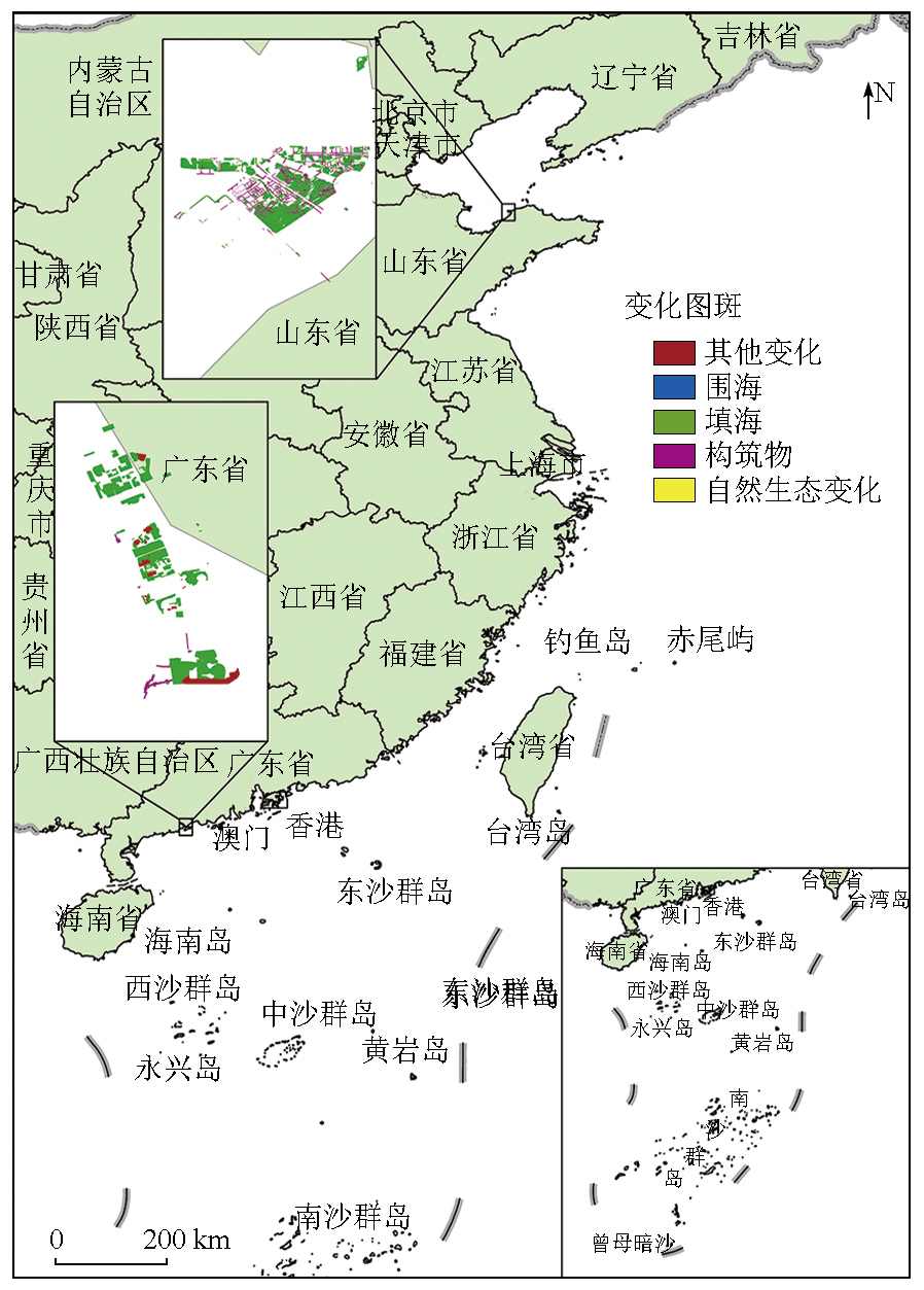
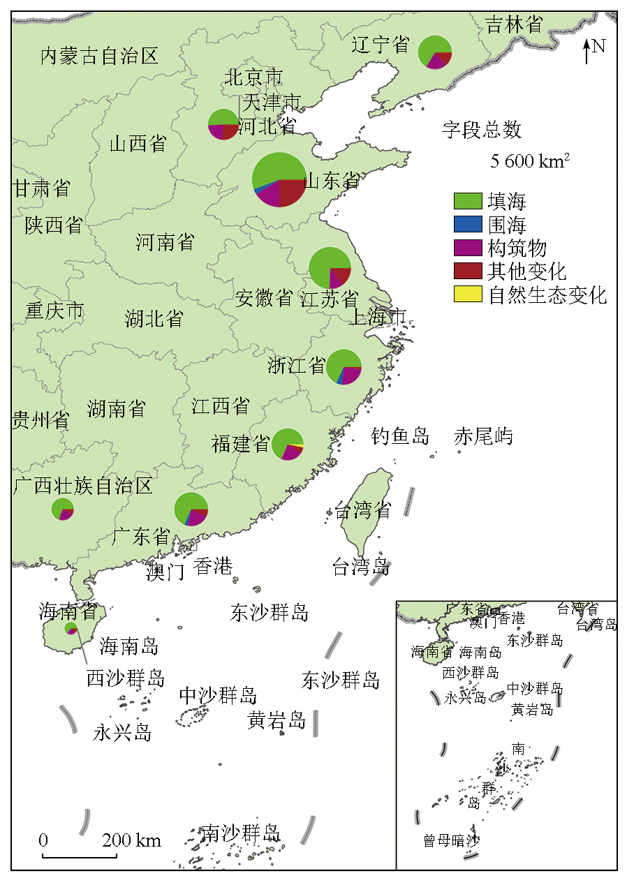
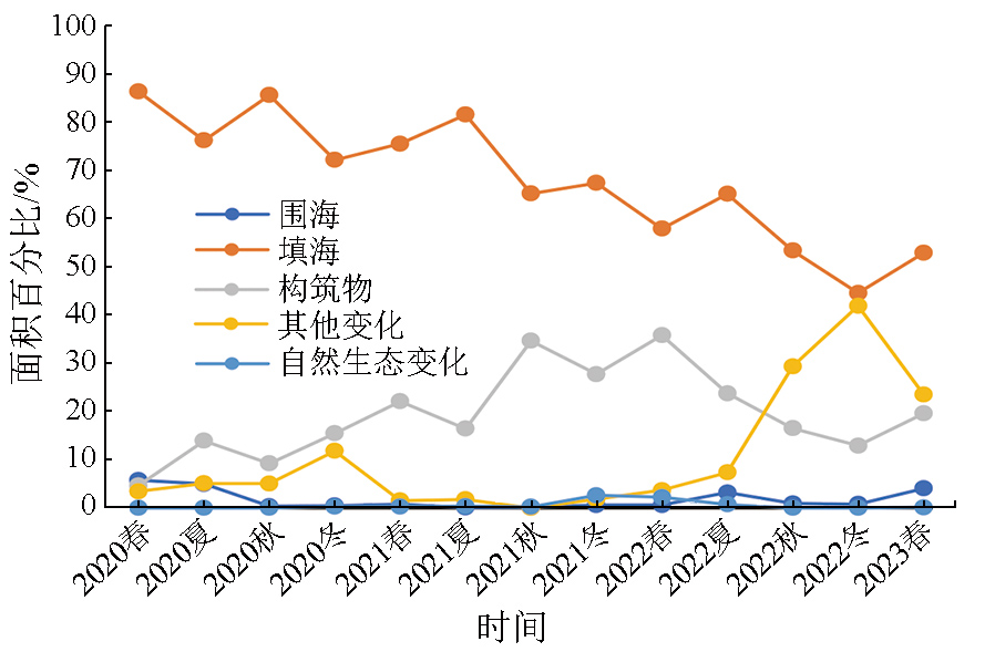
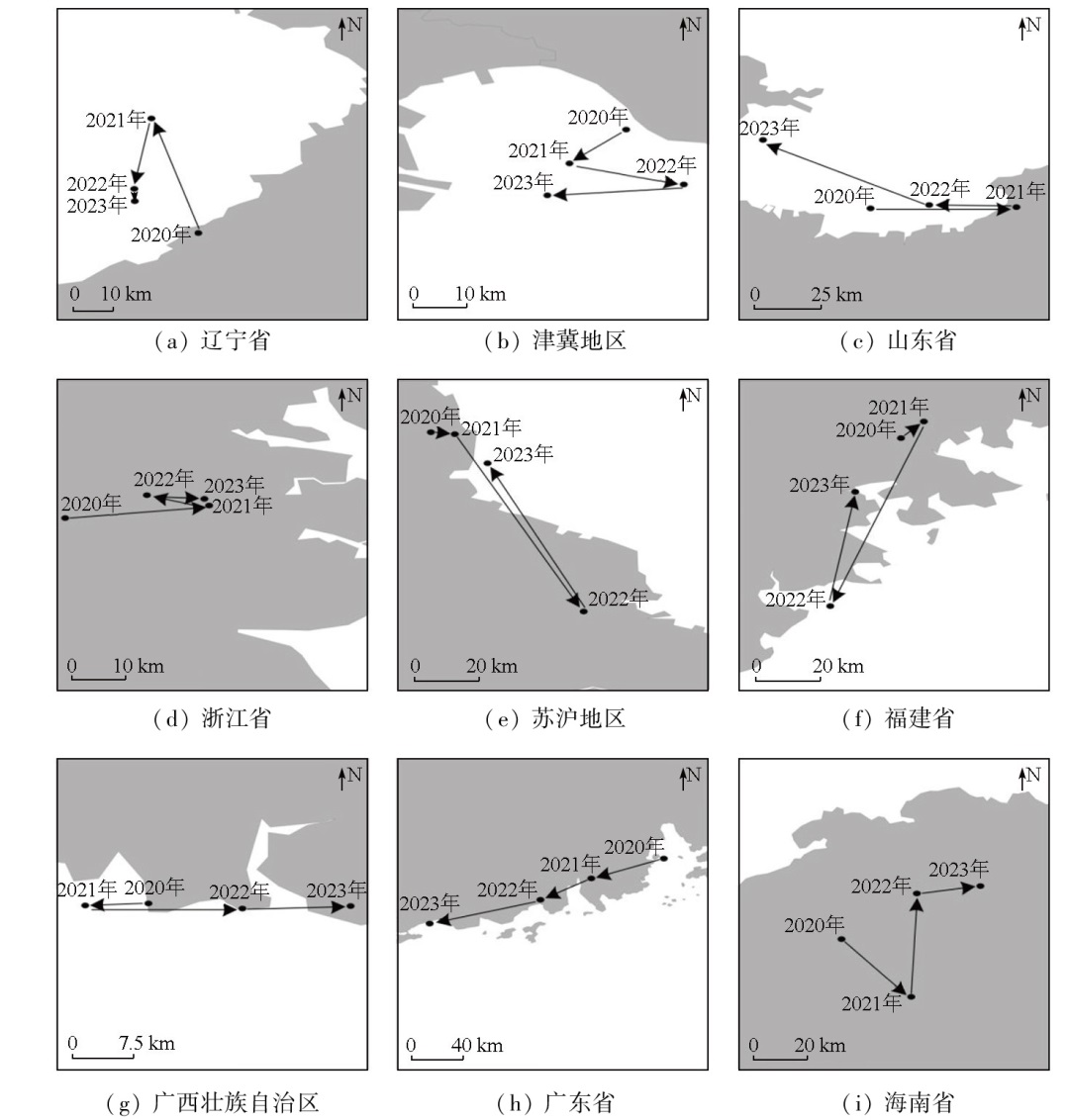
Abstract The analysis of patches showing changes in coastal areas of the Chinese mainland tends to encounter challenges such as low image resolution, long time intervals, and limited spatial coverage. This study aims to obtain high-frequency, accurate information on changes in coastal areas nationwide. This will facilitate the dynamic monitoring of marine resources and the implementation of relevant protection policies for coastal areas in China. To this end, using domestic high-resolution remote sensing data of 15 days (i.e., one cycle), as well as the iteratively reweighted multivariate alteration detection (IR-MAD) algorithm combined with visual interpretation, this study extracted patches reflecting 2020—2023 changes along the coasts of 11 provinces and cities in the Chinese mainland. Accordingly, this study analyzed their spatiotemporal characteristics, landscape patterns, and spatial correlation. The results indicate distinct directional changes in the patches. The patches reflecting changes from sea enclosure to reclamation exhibited the largest areas across various investigated areas. Except for Hainan Province, the area of this type of patches exceeded 1 000 km2. The proportions of patches reflecting different types of changes gradually tended to be balanced. In the winter of 2022, the proportion of patches showing changes in the reclamation dropped below 50% for the first time. The aggregation degree of patches reflecting various types of changes showed increasing trends, suggesting that patches reflecting various changes will become more concentrated in the future. The centroids of these patches of various regions shifted in varying directions, and these patches exhibited significant spatial correlation within a 20 km range.
|
| Keywords
coastal area
high-frequency
high-resolution
patch reflecting changes
spatiotemporal evolution analysis
|
|
|
|
Issue Date: 03 September 2025
|
|
|
| [1] |
李秀梅, 袁承志, 李月洋. 渤海湾海岸带遥感监测及时空变化[J]. 国土资源遥感, 2013, 25(2):156-163.doi:10.6046/gtzyyg.2013.02.26.
|
| [1] |
Li X M, Yuan C Z, Li Y Y. Remote sensing monitoring and spatial-temporal variation of Bohai Bay coastal zone[J]. Remote Sensing for Land and Resources, 2013, 25(2):156-163.doi:10.6046/gtzyyg.2013.02.26.
|
| [2] |
魏帆, 韩广轩, 张金萍, 等. 1985—2015年围填海活动影响下的环渤海滨海湿地演变特征[J]. 生态学杂志, 2018, 37(5):1527-1537.
|
| [2] |
Wei F, Han G X, Zhang J P, et al. Evolution of coastal wetlands under the influence of sea reclamation in Bohai Rim during 1985-2015.[J]. Ecological Processes, 2018, 37(5):1527-153.
|
| [3] |
何苏玲, 贺增红, 潘继亚, 等. 基于多模型的县域土地利用/土地覆盖模拟[J]. 自然资源遥感, 2023, 35(4):201-213.doi:10.6046/zrzyyg.2022274.
|
| [3] |
He S L, He Z H, Pan J Y, et al. County-scale land use/land cover simulation based on multiple models[J]. Remote Sensing for Natural Resources, 2023, 35(4):201-213.doi:10.6046/zrzyyg.2022274.
|
| [4] |
寇财垚, 满卫东, 张永彬, 等. 围填海背景下唐山市滨海湿地景观格局演变研究[J]. 湿地科学, 2023, 21(4):533-540
|
| [4] |
Kou C Y, Man W D, Zhang Y B, et al. Landscape pattern evolution of coastal wetlands in Tangshan City under the background of reclamation[J]. Wetland Science, 2023, 21(4):533-540.
|
| [5] |
武艺杰, 孔雪松. 江苏省“生态-农业-建设”用地空间格局模拟及发展模式选择[J]. 自然资源遥感, 2022, 34(1):238-248.doi:10.6046/zrzyyg.2021102.
|
| [5] |
Wu Y J, Kong X S. Simulation and development mode suggestions of the spatial pattern of “ecology-agriculture-construction” land in Jiangsu Province[J]. Remote Sensing for Natural Resources, 2022, 34(1):238-248.doi:10.6046/zrzyyg.2021102.
|
| [6] |
崔保山, 谢湉, 王青, 等. 大规模围填海对滨海湿地的影响与对策[J]. 中国科学院院刊, 2017, 32(4):418-425.
|
| [6] |
Cui B S, Xie T, Wang Q, et al. Impact of large-scale reclamation on coastal wetlands and implications for ecological restoration,compensation,and sustainable exploitation framework[J]. Bulletin of Chinese Academy of Sciences, 2017, 32(4):418-425.
|
| [7] |
苏涛, 牛超, 詹诚, 等. 广西围填海进程及其对近海生态和生物资源的影响分析[J]. 广西科学院学报, 2018, 34(3):228-234.
|
| [7] |
Su T, Niu C, Zhan C, et al. Study on the process of the coastal reclamation and its impact on coastal ecological and marine biological resources in Guangxi Zhuang Autonomous Region[J]. Journal of Guangxi Academy of Sciences, 2018, 34(3):228-234.
|
| [8] |
陈克亮, 吴侃侃, 黄海萍, 等. 我国海洋生态修复政策现状、问题及建议[J]. 应用海洋学学报, 2021, 40(1):170-178.
|
| [8] |
Cheng K L, Wu K K, Huang H P, et al. Marine ecological restoration policies in China:Status,problems and suggestions[J]. Journal of Applied Oceanography, 2021, 40(1):170-178.
|
| [9] |
徐鹤, 张玉新, 侯西勇, 等. 2010—2020年中国沿海主要海湾形态变化特征[J]. 自然资源学报, 2022, 37(4):1010-1024.
doi: 10.31497/zrzyxb.20220412
|
| [9] |
Xu H, Zhang Y X, Hou X Y, et al. Morphological changes of major gulfs along the coast of China from 2010 to 2020[J]. Journal of Natural Resources, 2022, 37(4):1010-1024.
|
| [10] |
王琎, 吴志峰, 李少英, 等. 珠江口湾区海岸线及沿岸土地利用变化遥感监测与分析[J]. 地理科学, 2016, 36(12):1903-1911.
doi: 10.13249/j.cnki.sgs.2016.12.016
|
| [10] |
Wang J, Wu Z F, Li S Y, et al. Coastline and land use change detection and analysis with remote sensing in the Pearl River Estuary Gulf[J]. Scientia Geographica Sinica, 2016, 36(12):1903-1911.
doi: 10.13249/j.cnki.sgs.2016.12.016
|
| [11] |
王娟, 赵吉祥, 单春芝, 等. 基于集成学习的海岸带变化检测方法研究[J]. 海洋开发与管理, 2021, 38(7):48-54.
|
| [11] |
Wang J, Zhao J X, Shan C Z, et al. Research on coastal zone change detection method based on ensemble learning[J]. Ocean Development and Management, 2021, 38(7):48-54.
|
| [12] |
Nielsen A A, Hecheltjen A, Thonfeld F, et al. Automatic change detection in RapidEye data using the combined MAD and kernel MAF methods[C]// IEEE International Geoscience and Remote Sensing Symposium,IGARSS 2010.
|
| [13] |
Moghimi A, Ebadi H, Sadeghi V. Changes monitoring in multitemporal satellite images using iteratively reweighted multivariate alte-ration detection (IR-MAD) algorithm and support vector machine (SVM) classification[J]. Engineering Journal of Geospatial Information Technology, 2018, 6(2):64-77.
|
| [14] |
Wu C, Du B, Zhang L. Slow feature analysis for change detection in multispectral Imagery[J]. IEEE Transactions on Geoscience and Remote Sensing, 2014, 52(5):2858-2874.
|
| [15] |
付杰, 宋伦, 雷利元, 等. 最优尺度和随机森林算法下盘锦海岸带遥感监测[J]. 遥感信息, 2022, 37(2):7-15.
|
| [15] |
Fu J, Song L, Lei L Y, et al. Remote sensing monitoring of Panjin coastal zone based on optimal scale and random forest algorithm[J]. Remote Sensing Information, 2022, 37(2):7-15.
|
| [16] |
Chen H, Shi Z. A Spatial-temporal attention-based method and a new dataset for remote sensing image change detection[J]. Remote Sensing, 2020, 12(10):1662.
|
| [17] |
侯英卓, 纪灵, 邢前国, 等. 卫星遥感辅助的大型海藻养殖动态对比监测——以威海市为例[J]. 自然资源遥感, 2023, 35(2):34-41.doi:10.6046/zrzyyg.2022296.
|
| [17] |
Hou Y Z, Ji L, Xing Q G, et al. Satellite remote sensing-assisted comparative monitoring of dynamic characteristics of macroalgae aquaculture in Weihai City,Shandong Province,China[J]. Remote Sensing for Natural Resources, 2023, 35(2):34-41.doi:10.6046/zrzyyg.2022296.
|
| [18] |
易凤佳, 李仁东, 常变蓉, 等. 长株潭地区建设用地扩张遥感时空特征分析[J]. 国土资源遥感, 2015, 27(2):160-166.doi:10.6046/gtzyyg.2015.02.25.
|
| [18] |
Yi F J, Li R D, Chang B R, et al. Spatial-temporal features of construction land expansion in Changzhutan (Changsha-Zhuzhou-Xiangtan) area based on remote sensing[J]. Remote Sensing for Land and Resources, 2015, 27(2):160-166.doi:10.6046/gtzyyg.2015.02.25.
|
| [19] |
匡文慧, 张树文, 杜国明, 等. 2015—2020年中国土地利用变化遥感制图及时空特征分析[J]. 地理学报, 2022, 77(5):1056-1071.
doi: 10.11821/dlxb202205002
|
| [19] |
Kuang W H, Zhang S W, Du G M, et al. Remotely sensed mapping and analysis of spatio-temporal patterns of land use change across China in 2015—2020[J]. Acta Geographica Sinica, 2022, 77(5):1056-1071.
|
| [20] |
应超, 高扬, 田鹏, 等. 陆海统筹视角下温州市海岸带国土空间开发利用时空变化特征研究[J]. 海洋通报, 2023, 42(2):202-215.
|
| [20] |
Ying C, Gao Y, Tian P, Spatial-temporal variation characteristics of territorial space development and utilization in Wenzhou coastal zone from the perspective of land-sea integration[J]. Marine Science Bulletin, 2023, 42(2):202-215.
|
| [21] |
温礼, 吴海平, 姜方方, 等. 高分遥感影像的围填海变化图斑自动提取方法[J]. 测绘科学, 2015, 40(6):42-45,76.
|
| [21] |
Wen B, Wu H P, Jiang F F, et al. Approach for assimilating land use spatial data at various times[J]. Science of Surveying and Mapping. 2015, 40(6):42-45,76.
|
| [22] |
于枫世, 隋毅, 王常颖, 等. 基于深度学习的高分辨率卫星遥感影像围填海检测识别[J]. 遥感技术与应用, 2022, 37(4):789-799.
doi: 10.11873/j.issn.1004-0323.2022.4.0789
|
| [22] |
Yu F S, Sui Y, Wang C Y, et al. Reclamation detection and recognition of high resolution satellite remote sensing image based on deep learning[J], Remote Sensing Technology and Application, 2022, 37(4):789-799.
|
|
Viewed |
|
|
|
Full text
|
|
|
|
|
Abstract
|
|
|
|
|
Cited |
|
|
|
|
| |
Shared |
|
|
|
|
| |
Discussed |
|
|
|
|
 2025,
Vol. 37
2025,
Vol. 37