|
|
|
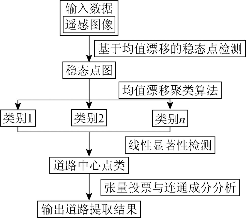
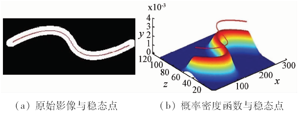
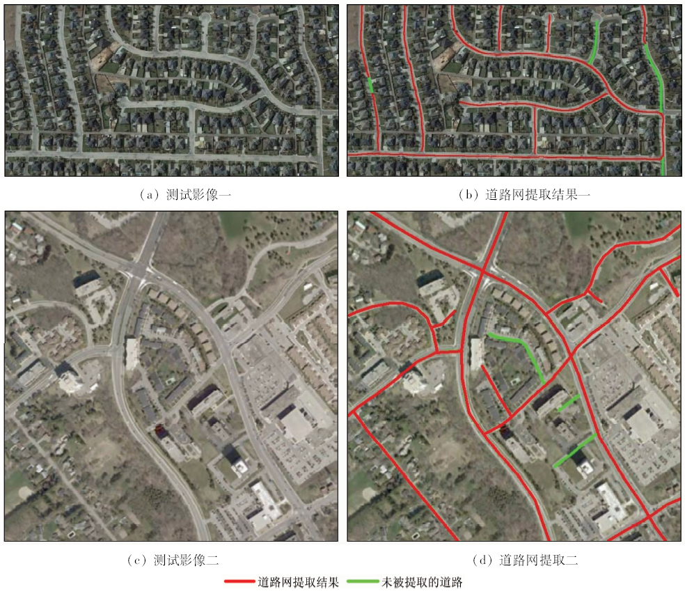
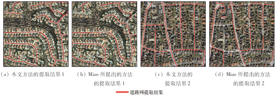
Abstract Roads on the high-resolution remote sensing images perform the stripe homogeneous region with ribbon-like shape and approximate width. According to these features, this paper presents a simple yet effective method of delineating road networks from high-resolution remote sensing images, which combines multi features and methods. The proposed method consists of three main steps. First, the mean shift algorithm is utilized to detect the modes of density of image points in spectral-spatial space which contain potential road center points and then detected mode points are classified into different classes by mean shift-based clustering on the basis of spectral information. Next, the combination of Gabor filtering and tensor encoding is used to identify the road class and to extract road center points. Lastly, road network is generated from detected road center points by means of tensor voting and connected component analysis. The experimental results demonstrate good performances of the proposed method in road network extraction, much better than the method proposed by Miao et al.
|
| Keywords
high-resolution
remote sensing image
homogeneity
mean shift
road networks construction
|
|
|
|
Corresponding Authors:
Fanzhi CAO
E-mail: 513572289@qq.com
|
|
Issue Date: 10 September 2018
|
|
|
| [1] |
刘扬, 付征叶, 郑逢斌 . 高分辨率遥感影像目标分类与识别研究进展[J]. 地球信息科学学报, 2015,17(9):1080-1091.
doi: 10.3724/SP.J.1047.2015.01080
url: http://d.wanfangdata.com.cn/Periodical/dqxxkx201509010
|
| [1] |
Liu Y, Fu Z Y, Zheng F B . Review on high resolution remote sensing image classification and recognition[J]. Journal of Geo-Information Science, 2015,17(9):1080-1091.
|
| [2] |
史文中, 朱长青, 王昱 . 从遥感影像提取道路特征的方法综述与展望[J]. 测绘学报, 2001,30(3):257-262.
|
| [2] |
Shi W Z, Zhu C Q, Wang Y . Road feature extraction from remotely sensed image:review and prospects[J]. Acta Geodaetica et Cartographica Sinica, 2001,30(3):257-262.
|
| [3] |
周绍光, 陈超, 岳建平 . 形状先验和图割的高分辨率遥感影像道路段提取[J]. 测绘学报, 2014,43(1):60-65.
|
| [3] |
Zhou S G, Chen C, Yue J P . Extracting roads from high-resolution RS images based on shape priors and graph Cuts[J]. Acta Geodaetica et Cartographica Sinica, 2014,43(1):60-65.
|
| [4] |
周绍光, 向晶, 邱伟 , 等. 基于高分辨率影像的道路中心线提取技术研究[J]. 国土资源遥感, 2015,27(4):21-26.doi: 10.6046/gtzyyg.2015.04.04.
doi: 10.6046/gtzyyg.2015.04.04
|
| [4] |
Zhou S G, Xiang J, Qiu W , et al. A study of road centerline extraction from high resolution image[J]. Remote Sensing for Land and Resources, 2015,27(4):21-26.doi: 10.6046/gtzyyg.2015.04.04.
|
| [5] |
雷小奇, 王卫星, 赖均 . 一种基于形状特征进行高分辨率遥感影像道路提取方法[J]. 测绘学报, 2009,38(5):457-465.
|
| [5] |
Lei X Q, Wang W X, Lai J . A method of road extraction from high-resolution remote sensing images based on shape features[J]. Acta Geodaetica et Cartographica Sinica, 2009,38(5):457-465.
|
| [6] |
朱长青, 王耀革, 马秋禾 , 等. 基于形态分割的高分辨率遥感影像道路提取[J]. 测绘学报, 2004,33(4):347-351.
doi: 10.3321/j.issn:1001-1595.2004.04.013
url: http://d.wanfangdata.com.cn/Periodical_chxb200404013.aspx
|
| [6] |
Zhu C Q, Wang Y G, Ma Q H , et al. Road extraction from high-resolution remotely sensed image based on morphological segmentation[J]. Acta Geodaetica et Cartographica Sinica, 2004,33(4):347-351.
|
| [7] |
Poullis C, You S Y . Delineation and geometric modeling of road networks[J]. ISPRS Journal of Photogrammetry and Remote Sensing, 2010,65(2):165-181.
doi: 10.1016/j.isprsjprs.2009.10.004
url: http://linkinghub.elsevier.com/retrieve/pii/S0924271609001233
|
| [8] |
Mena J B . State of the art on automatic road extraction for GIS update:A novel classification[J]. Pattern Recognition Letters, 2003,24(16):3037-3058.
doi: 10.1016/S0167-8655(03)00164-8
url: http://linkinghub.elsevier.com/retrieve/pii/S0167865503001648
|
| [9] |
Song M J, Civco D . Road extraction using SVM and image segmentation[J]. Photogrammetric Engineering and Remote Sensing, 2004,70(12):1365-1371.
doi: 10.14358/PERS.70.12.1365
url: http://openurl.ingenta.com/content/xref?genre=article&issn=0099-1112&volume=70&issue=12&spage=1365
|
| [10] |
Shi W Z, Miao Z L, Wang Q M , et al. Spectral-spatial classification and shape features for urban road centerline extraction[J]. IEEE Geoscience and Remote Sensing Letters, 2014,11(4):788-792.
doi: 10.1109/LGRS.2013.2279034
url: http://ieeexplore.ieee.org/document/6594858/
|
| [11] |
Miao Z L, Shi W Z, Zhang H , et al. Road centerline extraction from high-resolution imagery based on shape features and multivariate adaptive regression splines[J]. IEEE Geoscience and Remote Sensing Letters, 2013,10(3):583-587.
doi: 10.1109/LGRS.2012.2214761
url: http://ieeexplore.ieee.org/document/6329404/
|
| [12] |
Miao Z L, Shi W Z . Road centreline extraction from classified images by using the geodesic method[J]. Remote Sensing Letters, 2014,5(4):367-376.
doi: 10.1080/2150704X.2014.907935
url: http://www.tandfonline.com/doi/abs/10.1080/2150704X.2014.907935
|
| [13] |
Das S, Mirnalinee T T, Varghese K . Use of salient features for the design of a multistage framework to extract roads from high-resolution multispectral satellite images[J]. IEEE Transactions on Geoscience and Remote Sensing, 2011,49(10):3906-3931.
doi: 10.1109/TGRS.2011.2136381
url: http://ieeexplore.ieee.org/document/5766732/
|
| [14] |
曹帆之, 朱述龙, 朱宝山 , 等. 均值漂移与卡尔曼滤波相结合的遥感影像道路中心线追踪算法[J]. 测绘学报, 2016,45(2):205-212,223.
url: http://d.wanfangdata.com.cn/Periodical/chxb201602013
|
| [14] |
Cao F Z, Zhu S L, Zhu B S , et al. Tracking Road centerlines from remotely sensed imagery using mean shift and Kalman filtering[J]. Acta Geodaetica et Cartographica Sinica, 2016,45(2):205-212,223.
|
| [15] |
Fukunaga K, Hostetler L D . The estimation of the gradient of a density function,with applications in pattern recognition[J]. IEEE Transactions on Information Theory, 1975,21(1):32-40.
doi: 10.1109/TIT.1975.1055330
url: http://ieeexplore.ieee.org/document/1055330/
|
| [16] |
Cheng Y Z . Mean shift,mode seeking, and clustering[J]. IEEE Transactions on Pattern Analysis and Machine Intelligence, 1995,17(8):790-799.
doi: 10.1109/34.400568
url: http://ieeexplore.ieee.org/document/400568/
|
| [17] |
Cover T M, Thomas J A . Elements of Information Theory[M]. Chichester:John Wiley & Sons, 2012.
|
| [18] |
Daugman J G . Uncertainty relation for resolution in space,spatial frequency,and orientation optimized by two-dimensional visual cortical filters[J]. Journal of the Optical Society of America A, 1985,2(7):1160-1169.
doi: 10.1364/JOSAA.2.001160
url: https://www.osapublishing.org/abstract.cfm?URI=josaa-2-7-1160
|
| [19] |
Medioni G, Tang C K, Lee M S . Tensor voting: theory and applications[J]. Proceedings of Rfia, 2000,34(8):1482-1495.
doi: 10.1109/TPAMI.2011.250
url: http://www.researchgate.net/publication/244954632_Tensor_Voting_Theory_and_Applications
|
| [20] |
Mordohai P, Medioni G . Tensor Voting:A Perceptual Organization Approach to Computer Vision and Machine Learning[M]. California: Morgan & Claypool, 2006: 1-136.
|
|
Viewed |
|
|
|
Full text
|
|
|
|
|
Abstract
|
|
|
|
|
Cited |
|
|
|
|
| |
Shared |
|
|
|
|
| |
Discussed |
|
|
|
|
 2018,
Vol. 30
2018,
Vol. 30
 ), Wen CAO, Shuxiang WANG