Please wait a minute...
 
Remote Sensing for Land & Resources    2018, Vol. 30 Issue (1) : 116-120     DOI: 10.6046/gtzyyg.2018.01.16
Orginal Article |
Remote sensing monitoring of mining land in a certain area of Shanxi Province
Haiqing WANG1(), Mingde WU2, Qiong LIU1, Guangzhao LI3, Hao WANG1, Li LI1
1. China Aero Geophysical Survey and Remote Sensing Center for Land and Resources,Beijing 100083,China
2. Qinghai Bureau of Environmental Geology and Exploration, Xining 810007,China
3. School of the Earth and Resources, China University of Geosciences(Beijing),Beijing 100083,China
Download: PDF(1119 KB)   HTML
Export: BibTeX | EndNote | Reference Manager | ProCite | RefWorks    
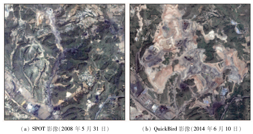
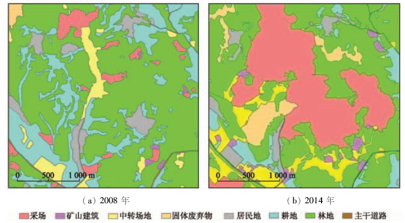
Abstract  

The remote sensing images which were obtained respectively in 2008 and 2014 were used in a certain area of Shanxi Province. By using ArcGIS softwere, human and computer interaction interpretation method was used to delineate the mining land and non-mining land respectively. The monitoring results show that, from 2008 to 2014, the proportion of mining land in the study area increased by about 35%, and the mining lands grew rapidly. The change of mining manner was the main reason for the increase of mining land. The increase of mining land was mainly attributed to the occupation of the forest land and cultivated land.

Keywords mining      occupied land      remote sensing     
:  TP79  
  P627  
Issue Date: 08 February 2018
Service
E-mail this article
E-mail Alert
RSS
Articles by authors
Haiqing WANG
Mingde WU
Qiong LIU
Guangzhao LI
Hao WANG
Li LI
Cite this article:   
Haiqing WANG,Mingde WU,Qiong LIU, et al. Remote sensing monitoring of mining land in a certain area of Shanxi Province[J]. Remote Sensing for Land & Resources, 2018, 30(1): 116-120.
URL:  
https://www.gtzyyg.com/EN/10.6046/gtzyyg.2018.01.16     OR     https://www.gtzyyg.com/EN/Y2018/V30/I1/116
Fig.1  Remote sensing images of study area
获取日期 卫星 分辨率/m 波段数 本文波段组合
20080531 SPOT 2.50 3 B4(R),B1(G),B2(B)
20140610 QuickBird 0.61 3 B3(R),B2(G),B1(B)
Tab.1  Basic information of remote sensing data
Fig.2  Remote sensing identification keys of mining lands
用地类型 色调 形状 附着地物 地形
采场 土黄色、黑色等,根据矿种不同会有所变化 不规则,受矿体延伸情况控制 可能有车辆或机械 人工开挖的负地形
矿山建筑 蓝色、红色、灰色等 矩形或矩形组合 附近可能有车辆
中转场地 黑色、土黄色等,根据用途不同会有所变化 不规则,根据用途不同会有所变化 转运场地有车辆; 选矿场有机械; 矿石堆可能有车辆或机械
固体废弃物 土黄色、灰黑色等,根据物质不同会有所变化 不规则,受堆积场所和堆积方式控制 可能有车辆; 机械 人工堆积的正地形
Tab.2  Description of remote sensing identification keys of mining lands
用地类型 2008年面积/m2 2008年占比/% 2014年面积/m2 2014年占比/% 增加面积/m2
矿业用地 采场 458 392 4.93 2 707 375 29.11 2 248 983
矿山建筑 39 408 0.42 192 245 2.07 152 837
中转场地 478 927 5.15 871 749 9.37 392 822
固体废弃物 67 537 0.73 543 409 5.84 475 872
小计 1 044 264 11.23 4 314 778 46.39 3 270 514
非矿业用地 居民地 486 504 5.23 390 875 4.21 -95 629
耕地 2 089 797 22.47 561 994 6.04 -1 527 803
林地 5 620 580 60.44 3 973 542 42.73 -1 647 038
主干道路 58 860 0.63 58 816 0.63 -44
小计 8 255 741 88.77 4 985 227 53.61 -3 270 514
合计 9 300 005 100.00 9 300 005 100.00
Tab.3  List for land area in study area
Fig.3  Results of remote sensing survey for mining land
Fig.4  Changes of mining land
Fig.5  Increased mining land
[1] 来欣捧. 矿山建设节约集约用地技术研究[J]. 金属矿山, 2015(2):155-159.
[1] Lai X P.Study on the economical and intensive land use technology for mine construction[J]. Metal Mine, 2015(2):155-159.
[2] 郑娟尔,袁国华,章岳峰.矿业用地制度:问题与对策[J].国土资源科技管理,2015,32(6):76-83.
[2] Zheng J E,Yuan G H,Zhang Y F.Mining land:Problems and solutions[J].Scientific and Technological Management of Land and Resources,2015,32(6):76-83.
[3] 杨慧丽,付梅臣.法规范视角下矿业用地盘活模式的归纳与设计[J].中国矿业,2016,25(3):21-24.
[3] Yang H L,Fu M C.Design and induction for patterns of revitalizing mine land from the view of law[J].China Mining Magazine,2016,25(3):21-24.
[4] 刘慧芳,刘友兆,毕如田,等.基于用地竞争的矿业废弃地再利用用地类型判定[J].农业工程学报,2016,32(10):258-266.
[4] Liu H F,Liu Y Z,Bi R T,et al.Reuse type judgment of mining wasteland based on land use competitiveness[J].Transactions of the Chinese Society of Agricultural Engineering,2016,32(10):258-266.
[5] 杨显华,黄洁,田立,等.应用遥感方法研究四川主要矿山占地现状和变迁[J].四川地质学报,2012,32(4):482-486.
[5] Yang X H,Huang J,Tian L,et al.The application of remote sensing technique to the study of present situation and changes of land occupied by main mines in Sichuan[J].Acta Geologica Sichuan,2012,32(4):482-486.
[6] 何亮柱,洪金益,张建国,等.基于IKONOS数据的矿山开发占地信息提取[J].国土资源遥感,2013.25(1):150-154.doi:10.6046/gtzyyg.2013.01.26.
[6] He L Z,Hong J Y,Zhang J G,et al.Research on extraction of land information used by mining development based on IKONOS remote sensing data[J].Remote Sensing for Land and Resources,2013,25(1):150-154.doi:10.6046/gtzyyg.2013.01.26.
[7] 王耿明,朱俊凤,武国忠,等.广东省矿山开采占地情况遥感监测与综合研究[J].华南地质与矿产,2015,31(4):406-413.
[7] Wang G M,Zhu J F,Wu G Z,et al.The remote sensing surveillance and compositive research of mine exploitation impropriate soil in Guangdong Province[J].Geology and Mineral Resources of South China,2015,31(4):406-413.
[8] 张永杰,韩芬,杨阳,等.基于QuickBird影像的石炭井矿区矿山开发占地调查[J].宁夏工程技术,2015,14(4):331-333.
[8] Zhang Y J,Han F,Yang Y,et al.QuickBird image based investigation on land occupation of exploitation mining in Shitanjing mine area[J].Ningxia Engineering Technology,2015,14(4):331-333.
[1] LIU Wen, WANG Meng, SONG Ban, YU Tianbin, HUANG Xichao, JIANG Yu, SUN Yujiang. Surveys and chain structure study of potential hazards of ice avalanches based on optical remote sensing technology: A case study of southeast Tibet[J]. Remote Sensing for Natural Resources, 2022, 34(1): 265-276.
[2] WANG Qian, REN Guangli. Application of hyperspectral remote sensing data-based anomaly extraction in copper-gold prospecting in the Solake area in the Altyn metallogenic belt, Xinjiang[J]. Remote Sensing for Natural Resources, 2022, 34(1): 277-285.
[3] LYU Pin, XIONG Liyuan, XU Zhengqiang, ZHOU Xuecheng. FME-based method for attribute consistency checking of vector data of mines obtained from remote sensing monitoring[J]. Remote Sensing for Natural Resources, 2022, 34(1): 293-298.
[4] ZHANG Daming, ZHANG Xueyong, LI Lu, LIU Huayong. Remote sensing image segmentation based on Parzen window density estimation of super-pixels[J]. Remote Sensing for Natural Resources, 2022, 34(1): 53-60.
[5] XUE Bai, WANG Yizhe, LIU Shuhan, YUE Mingyu, WANG Yiying, ZHAO Shihu. Change detection of high-resolution remote sensing images based on Siamese network[J]. Remote Sensing for Natural Resources, 2022, 34(1): 61-66.
[6] SONG Renbo, ZHU Yuxin, GUO Renjie, ZHAO Pengfei, ZHAO Kexin, ZHU Jie, CHEN Ying. A method for 3D modeling of urban buildings based on multi-source data integration[J]. Remote Sensing for Natural Resources, 2022, 34(1): 93-105.
[7] LI Weiguang, HOU Meiting. A review of reconstruction methods for remote-sensing-based time series data of vegetation and some examples[J]. Remote Sensing for Natural Resources, 2022, 34(1): 1-9.
[8] DING Bo, LI Wei, HU Ke. Inversion of total suspended matter concentration in Maowei Sea and its estuary, Southwest China using contemporaneous optical data and GF SAR data[J]. Remote Sensing for Natural Resources, 2022, 34(1): 10-17.
[9] GAO Qi, WANG Yuzhen, FENG Chunhui, MA Ziqiang, LIU Weiyang, PENG Jie, JI Yanzhen. Remote sensing inversion of desert soil moisture based on improved spectral indices[J]. Remote Sensing for Natural Resources, 2022, 34(1): 142-150.
[10] YANG Wang, HE Yi, ZHANG Lifeng, WANG Wenhui, CHEN Youdong, CHEN Yi. InSAR monitoring of 3D surface deformation in Jinchuan mining area, Gansu Province[J]. Remote Sensing for Natural Resources, 2022, 34(1): 177-188.
[11] ZHANG Qinrui, ZHAO Liangjun, LIN Guojun, WAN Honglin. Ecological environment assessment of three-river confluence in Yibin City using improved remote sensing ecological index[J]. Remote Sensing for Natural Resources, 2022, 34(1): 230-237.
[12] HE Peng, TONG Liqiang, GUO Zhaocheng, TU Jienan, WANG Genhou. A study on hidden risks of glacial lake outburst floods based on relief amplitude: A case study of eastern Shishapangma[J]. Remote Sensing for Natural Resources, 2022, 34(1): 257-264.
[13] LI Mengmeng, FAN Xueting, CHEN Chao, LI Qiannan, YANG Jin. Monitoring and interpretation of land subsidence in mining areas in Xuzhou City during 2016—2018[J]. Remote Sensing for Natural Resources, 2021, 33(4): 43-54.
[14] YU Xinli, SONG Yan, YANG Miao, HUANG Lei, ZHANG Yanjie. Multi-model and multi-scale scene recognition of shipbuilding enterprises based on convolutional neural network with spatial constraints[J]. Remote Sensing for Natural Resources, 2021, 33(4): 72-81.
[15] LI Yikun, YANG Yang, YANG Shuwen, WANG Zihao. A change vector analysis in posterior probability space combined with fuzzy C-means clustering and a Bayesian network[J]. Remote Sensing for Natural Resources, 2021, 33(4): 82-88.
Viewed
Full text


Abstract

Cited

  Shared   
  Discussed   
京ICP备05055290号-2
Copyright © 2017 Remote Sensing for Natural Resources
Support by Beijing Magtech