Please wait a minute...
 
Remote Sensing for Land & Resources    2018, Vol. 30 Issue (4) : 212-217     DOI: 10.6046/gtzyyg.2018.04.32
|
Research and implement on automatic production method of mine remote sensing monitoring interpretation record table
Mingguang DIAO1, Fang LIU1, Zhuantiao TAN1, Tao XUE1, Yanzuo WANG2
1. School of Information Engineering, China University of Geosciences(Beijing), Beijing 100083, China
2. China Aero Geophysical Survey and Remote Sensing Center for Land and Resources, Beijing 100083, China
Download: PDF(3569 KB)   HTML
Export: BibTeX | EndNote | Reference Manager | ProCite | RefWorks    
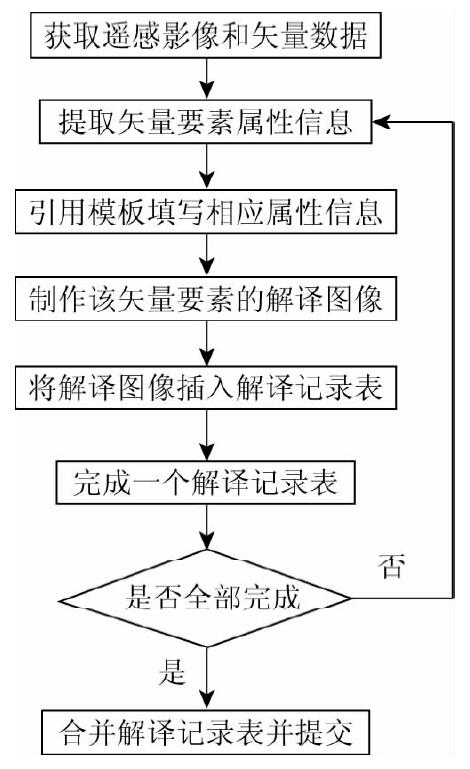
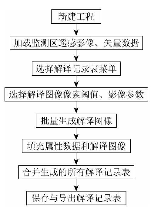
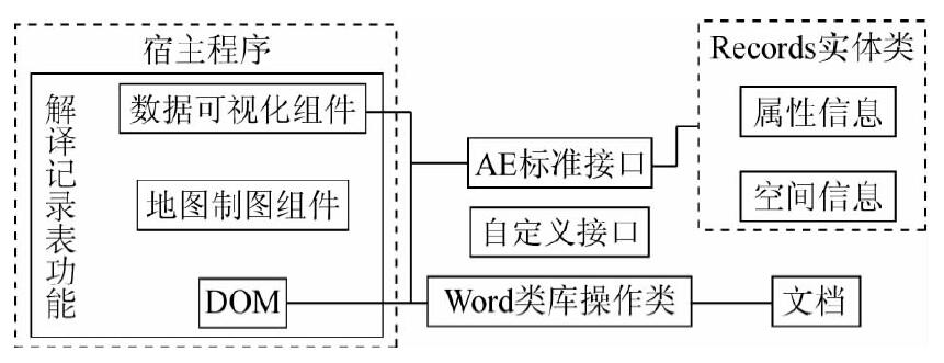
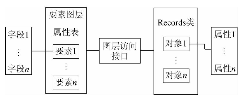
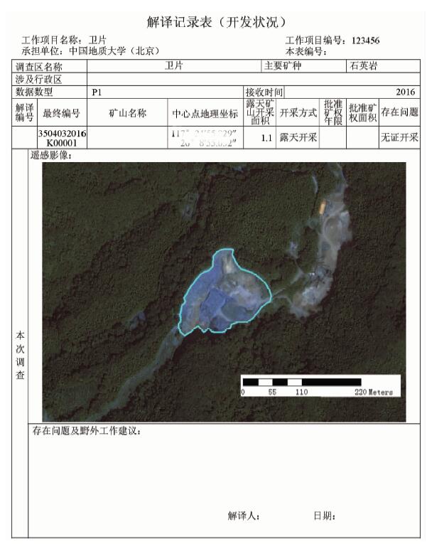
Abstract  

In the process of mine remote sensing monitoring, technicians need to use ArcMap to extract valuable information from geographic data and make the interpretation record table aimed at monitoring mineral exploitation. Manual interpretation record table has many problems, such as high cost, more professional skill requirements, heavy work load, format inconsistency and low accuracy of data. The method of automatically produced mine interpretation record table can automatically extract spatial and attribute information from geographic data based on ArcGIS Engine(AE) plug-in, then Word documents are edited based on document object model(DOM),and finally the production of interpretation record table is realized automatically.

Keywords AE      mine monitoring      document object model      interpretation record table      remote sensing image     
:  TP319  
Issue Date: 07 December 2018
Service
E-mail this article
E-mail Alert
RSS
Articles by authors
Mingguang DIAO
Fang LIU
Zhuantiao TAN
Tao XUE
Yanzuo WANG
Cite this article:   
Mingguang DIAO,Fang LIU,Zhuantiao TAN, et al. Research and implement on automatic production method of mine remote sensing monitoring interpretation record table[J]. Remote Sensing for Land & Resources, 2018, 30(4): 212-217.
URL:  
https://www.gtzyyg.com/EN/10.6046/gtzyyg.2018.04.32     OR     https://www.gtzyyg.com/EN/Y2018/V30/I4/212
Fig.1  Manual process of interpretation record table
Fig.2  Automatic process of interpretation record table
Fig.3  Frame of interpretation record table automatic production method
Fig.4  Mapping of layer and object
类名 类描述 属性
MapSurround 地图环境,父类 地图视图Map等
MapTitle 地图名,子类
Legend 图例,子类 样式Format、图标Icon和名称Name等
ScaleBar 比例尺,子类 分隔数Division、颜色BarColor和单位Units等
MarkerNorthArrow 指北针,子类 角度Angle、颜色Color和大小Size等
ScaleText 数字比例,子类 文本Text、单位MapUnits和样式Style等
Tab.1  Class of map surround
Fig.5  Exportable image format
Fig.6  Square pattern location
Fig.7  Mapping of object and document
Fig.8  Functional interface of interpretation record table
Fig.9  Automatically generated interpretation record table
[1] 刁明光, 薛涛, 李建存 , 等. 基于ArcGIS的矿山遥感监测成果编制系统[J]. 国土资源遥感, 2016,28(3):194-199.doi: 10.6046/gtzyyg.2016.03.30.
[1] Diao M G, Xue T, Li J C , et al. Production data compilation system of mine remote sensing monitoring based on ArcGIS[J]. Remote Sensing for Land and Resources, 2016,28(3):194-199.doi: 10.6046/gtzyyg.2016.03.30.
[2] 朱敏, 刘刚, 马海涛 , 等. 遥感影像目视解译矢量化分析[J]. 测绘与空间地理信息, 2010,33(4):67-69.
doi: 10.3969/j.issn.1672-5867.2010.04.020 url: http://d.wanfangdata.com.cn/Periodical/dbch201004020
[2] Zhu M, Liu G, Ma H T , et al. Visual interpretation vector analysis of remote sensing image[J]. Geomatics and Spatial Information Technology, 2010,33(4):67-69.
[3] 中国国土资源航空物探遥感中心.全国矿产资源开发环境遥感监测入库数据技术要求( 2017)[Z]. 2017-9.
[3] China Aero Geophysical Survey and Remote Sensing Center for Land and Resources. Production for Data Requirements for Database of Mine Remote Sensing Monitoring( 2017)[Z]. 2017-9.
[4] 施建辉 . 基于ArcGIS Engine的插件式应用系统的实现[J]. 测绘标准化, 2011,27(4):12-15.
url: http://www.cqvip.com/QK/96859X/201104/40362423.html
[4] Shi J H . The implementation of plugin application system based on ArcGIS Engine[J]. Standardization of Surveying and Mapping, 2011,27(4):12-15.
[5] 张扬, 李小娟, 陈莹 , 等. 基于ArcGIS Engine的专题制图模块的设计与实现——以北京市城市规划信息系统为例[J]. 首都师范大学学报(自然科学版), 2008,29(2):95-100.
doi: 10.3969/j.issn.1004-9398.2008.02.019 url: http://d.wanfangdata.com.cn/Periodical/sdsfdxxb-zr200802019
[5] Zhang Y, Li X J, Chen Y , et al. Design and realization of the thematic mapping module based on ArcGIS Engine:Take Beijing urban planning information system as example[J]. Journal of Capital Normal University(Natural Sciences Edition), 2008,29(2):95-100.
[6] 张康聪 . 地理信息系统导论(第7版)[M]. 北京: 电子工业出版社, 2014: 232-241.
[6] Zhang K C. Introduction to Geographic Information Systems(Seventh Edition)[M]. Beijing: Electronic Industry Press, 2014: 232-241.
[7] 微软 . Word对象模型概述[EB/OL].[2017-3-13].https://msdn.microsoft.com/zh-cn/library/kw65a0we.aspx.
[7] Microsoft.Word object model overview[EB/OL].[2017-3-13].https://msdn.microsoft.com/zh-cn/library/kw65a0we.aspx.
[1] ZHANG Daming, ZHANG Xueyong, LI Lu, LIU Huayong. Remote sensing image segmentation based on Parzen window density estimation of super-pixels[J]. Remote Sensing for Natural Resources, 2022, 34(1): 53-60.
[2] XUE Bai, WANG Yizhe, LIU Shuhan, YUE Mingyu, WANG Yiying, ZHAO Shihu. Change detection of high-resolution remote sensing images based on Siamese network[J]. Remote Sensing for Natural Resources, 2022, 34(1): 61-66.
[3] SONG Renbo, ZHU Yuxin, GUO Renjie, ZHAO Pengfei, ZHAO Kexin, ZHU Jie, CHEN Ying. A method for 3D modeling of urban buildings based on multi-source data integration[J]. Remote Sensing for Natural Resources, 2022, 34(1): 93-105.
[4] LI Yikun, YANG Yang, YANG Shuwen, WANG Zihao. A change vector analysis in posterior probability space combined with fuzzy C-means clustering and a Bayesian network[J]. Remote Sensing for Natural Resources, 2021, 33(4): 82-88.
[5] LIU Zhizhong, SONG Yingxu, YE Runqing. An analysis of rainstorm-induced landslides in northeast Chongqing on August 31, 2014 based on interpretation of remote sensing images[J]. Remote Sensing for Natural Resources, 2021, 33(4): 192-199.
[6] ZHANG Chengye, XING Jianghe, LI Jun, SANG Xiao. Recognition of the spatial scopes of tailing ponds based on U-Net and GF-6 images[J]. Remote Sensing for Natural Resources, 2021, 33(4): 252-257.
[7] SANG Xiao, ZHANG Chengye, LI Jun, ZHU Shoujie, XING Jianghe, WANG Jinyang, WANG Xingjuan, LI Jiayao, YANG Ying. Application of intensity analysis theory in the land use change in Yijin Holo Banner under the background of coal mining[J]. Remote Sensing for Natural Resources, 2021, 33(3): 148-155.
[8] WEI Geng, HOU Yuqiao, ZHA Yong. Analysis of aerosol type changes in Wuhan City under the outbreak of COVID-19 epidemic[J]. Remote Sensing for Natural Resources, 2021, 33(3): 238-245.
[9] WANG Yiuzhu, HUANG Liang, CHEN Pengdi, LI Wenguo, YU Xiaona. Change detection of remote sensing images based on the fusion of co-saliency difference images[J]. Remote Sensing for Natural Resources, 2021, 33(3): 89-96.
[10] LIU Wanjun, GAO Jiankang, QU Haicheng, JIANG Wentao. Ship detection based on multi-scale feature enhancement of remote sensing images[J]. Remote Sensing for Natural Resources, 2021, 33(3): 97-106.
[11] SHU Huiqin, FANG Junyong, LU Peng, GU Wanfa, WANG Xiao, ZHANG Xiaohong, LIU Xue, DING Lanpo. Research on fine recognition of site spatial archaeology based on multisource high-resolution data[J]. Remote Sensing for Land & Resources, 2021, 33(2): 162-171.
[12] BI Weihua, ZHAO Xingtao, YANG Huachao, BIAN Hefang, ZHANG Qiuzhao. Research on smartphone based UAV low-altitude oblique photogrammetry system and its applications[J]. Remote Sensing for Land & Resources, 2021, 33(2): 248-255.
[13] LU Qi, QIN Jun, YAO Xuedong, WU Yanlan, ZHU Haochen. Buildings extraction of GF-2 remote sensing image based on multi-layer perception network[J]. Remote Sensing for Land & Resources, 2021, 33(2): 75-84.
[14] HU Suliyang, LI Hui, GU Yansheng, HUANG Xianyu, ZHANG Zhiqi, WANG Yingchun. An analysis of land use changes and driving forces of Dajiuhu wetland in Shennongjia based on high resolution remote sensing images: Constraints from the multi-source and long-term remote sensing information[J]. Remote Sensing for Land & Resources, 2021, 33(1): 221-230.
[15] MENG Qing, BAI Hongying, ZHAO Ting, GUO Shaozhuang, QI Guizeng. The eco-barrier effect of Qinling Mountain on aerosols[J]. Remote Sensing for Land & Resources, 2021, 33(1): 240-248.
Viewed
Full text


Abstract

Cited

  Shared   
  Discussed   
京ICP备05055290号-2
Copyright © 2017 Remote Sensing for Natural Resources
Support by Beijing Magtech