|
|
|
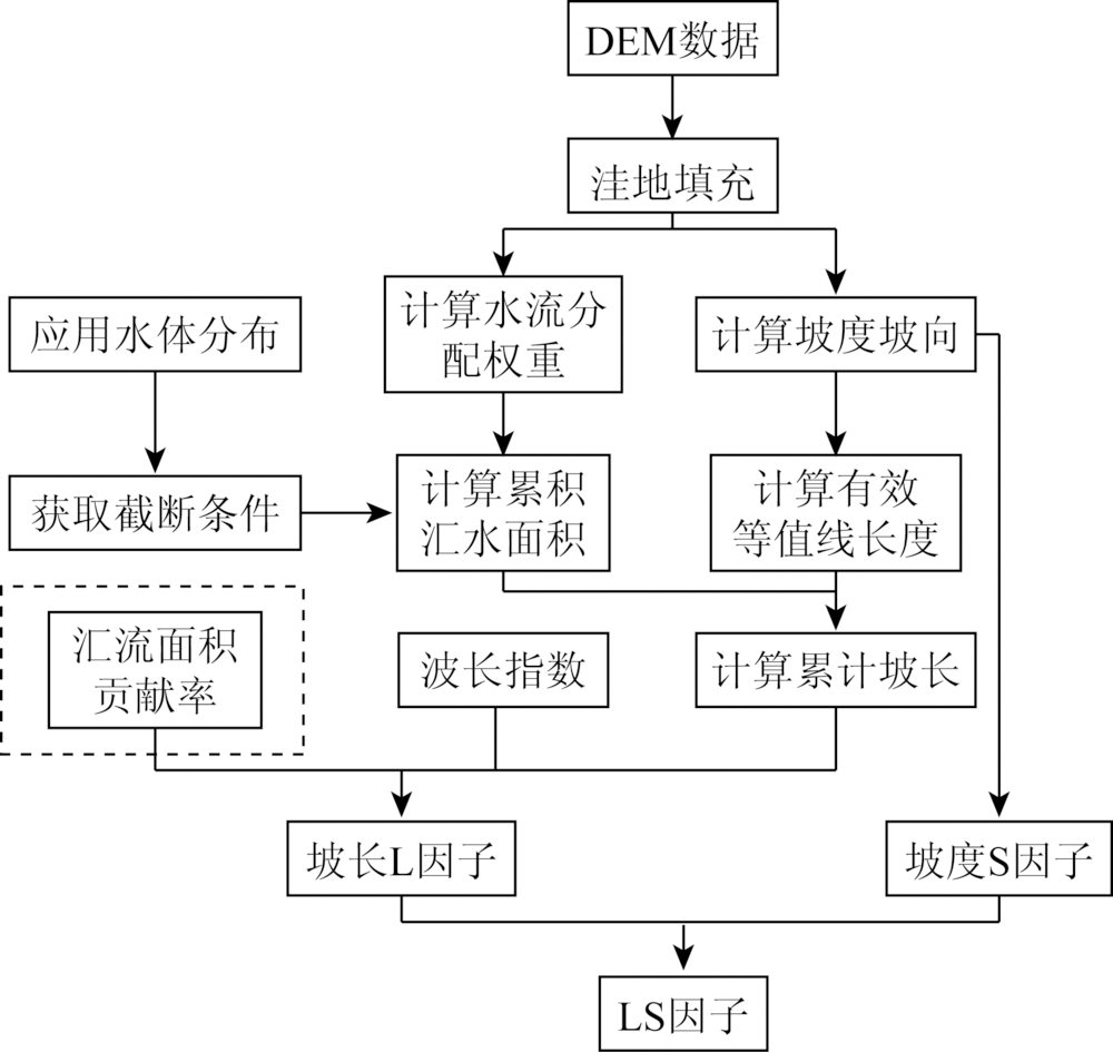
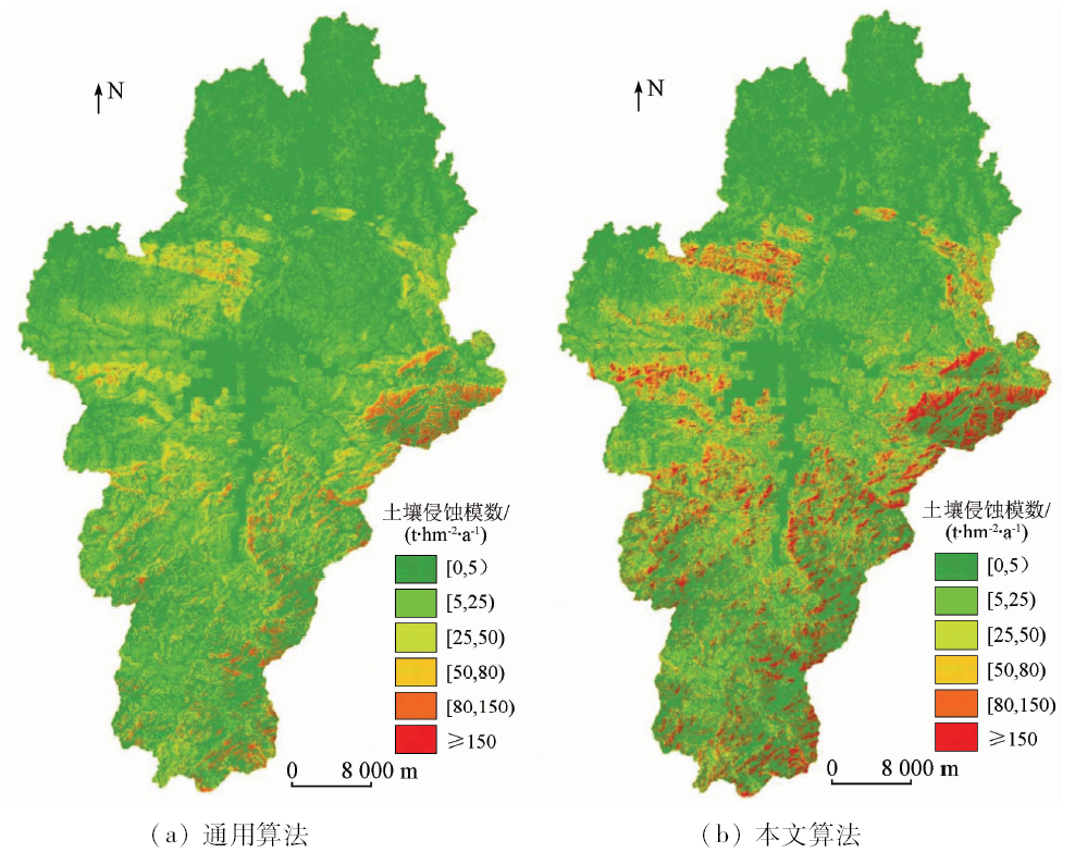
Abstract In this paper, a topographic factor extraction algorithm based on the accumulation of the multiple flow direction up-slope considering the effect of land use/vegetation on the confluence is proposed, which improves the topographic factor extraction algorithm in revised university soil loss equation (RUSLE) and improves the accuracy of soil erosion extraction. The spatial distribution of soil erosion intensity and its relationship with environmental factors in Shangcheng County of Huaihe River basin were studied by using geographic information system (GIS) and remote sensing (RS) techniques. The results show that the average annual soil erosion modulus is 28.16 t·hm -2·a -1, suggesting moderate erosion. The total erosion area reaches 905.95 km 2, soil erosion intensity and erosion modulus also increase significantly with the increase of slope. The study provides a technical example for the application of the RUSLE model to soil erosion assessment in the ecological functional region and provides an effective basis for soil erosion control and environmental sustainable development in this region.
|
| Keywords
soil erosion
topography factor
remote sensing
geographic information system
revised universal soil loss equation
|
|
|
|
Corresponding Authors:
Xiaoping LU
E-mail: lxp@huyp.edu.cn
|
|
Issue Date: 03 December 2019
|
|
|
| [1] |
陈世发 . 基于GIS的亚热带山地土地利用与土壤侵蚀关系研究——以粤北山区为例[J].干旱区资源与环境,2015(2):80-85.
|
| [1] |
Chen S F . Relationship between land use and soil erosion in the subtropical mountain areas of north Guangdong Province[J].Journal of Arid Land Resources and Environment,2015(2):80-85.
|
| [2] |
Qin W, Guo Q, Cao W , et al. A new RUSLE slope length factor and its application to soil erosion assessment in a Loess Plateau watershed[J]. Soil and Tillage Research, 2018,182:10-24.
|
| [3] |
Djoukbala O, Mazour M, Hasbaia M , et al. Estimating of water erosion in semiarid regions using RUSLE equation under GIS environment[J]. Environmental Earth Sciences, 2018,77(9):345.
|
| [4] |
张宏鸣, 杨勤科, 李锐 , 等. 基于GIS和多流向算法的流域坡度与坡长估算[J].农业工程学报,2012(10):159-164.
|
| [4] |
Zhang H M, Yang Q K, Li R , et al. Estimation methods of slope gradient and slope length in watershed based on GIS and multiple flow direction algorithm[J].Transactions of the Chinese Society of Agricultural Engineering,2012(10):159-164.
|
| [5] |
张宏鸣, 杨勤科, 李锐 , 等. 流域分布式侵蚀学坡长的估算方法研究[J].水利学报,2012(4):437-444.
|
| [5] |
Zhang H M, Yang Q K, Li R , et al. Research on the estimation of slope length in distributed watershed erosion[J].Journal of Hydraulic Engineering,2012(4):437-444.
|
| [6] |
胡刚, 宋慧, 石星军 . 基于单位汇水面积的地形因子特征评价[J].地理科学,2016(4):621-627.
|
| [6] |
Hu G, Song H, Shi X J . Evaluation of topography factors based on the unit contributing catchment area[J]. Scientia Geographica Sinica, 2016,36(4):621-627.
|
| [7] |
Mahala A . Soil erosion estimation using RUSLE and GIS techniques:A study of a plateau fringe region of tropical environment[J]. Arabian Journal of Geosciences, 2018,11(13).
|
| [8] |
Li Y, Bai X, Zhou Y , et al. Spatial-temporal evolution of soil erosion in a typical mountainous Karst basin in SW China,based on GIS and RUSLE[J]. Arabian Journal for Science and Engineering, 2016,41(1):209-221.
|
| [9] |
胡璐锦, 王亮, 陶坤旺 . 单流向算法与多流向算法下土壤侵蚀因子的比较研究[J].测绘科学,2014(6):35-39.
|
| [9] |
Hu L J, Wang L, Tao K W . Comparison of topographic factors based on single flow direction arithmetic and multiple flow direction arithmetic[J].Science of Surveying and Mapping,2014(6):35-39.
|
| [10] |
Desmet P J J, Govers G . A GIS procedure for automatically calculating the USLE LS factor on topographically complex landscape units[J]. Journal of Soil and Water Conservation, 1996,51(5):427.
|
| [11] |
雍斌, 张万昌, 陈艳华 . TOPMODEL中地形指数ln( α/tanβ)的新算法[J].地理研究, 2007(1):37-45.
|
| [11] |
Yong B, Zhang W C, Chen Y H . A new algorithm of the topographic index 1n( α/tanβ) in TOPMODEL and its resultant analysis[J].Geographical Research, 2007(1):37-45.
|
| [12] |
秦伟, 曹文洪, 左长清 , 等. 考虑沟-坡分异的黄土高原大中流域侵蚀产沙模型[J].应用基础与工程科学学报,2015(1):12-29.
|
| [12] |
Qin W, Cao W H, Zuo C Q , et al. Erosion and sediment yield model of big and middle scale watershed in Loess Plateau considering differentiation between upper and lower of the shoulder line of valleys[J].Journal of Basic Science and Engineering,2015(1):12-29.
|
| [13] |
秦伟, 朱清科, 张岩 . 基于GIS和RUSLE的黄土高原小流域土壤侵蚀评估[J].农业工程学报,2009(8):157-163.
|
| [13] |
Qin W, Zhu Q K, Zhang Y . Soil erosion assessment of small watershed in Loess Plateau based on GIS and RUSLE[J].Transactions of the CSAE,2009(8):157-163.
|
| [14] |
刘利峰, 毕华兴 . 单一流向算法和多流向算法下的地形指数比较研究——以山西吉县蔡家川小流域为例[J].水土保持研究,2006(6):309-310.
|
| [14] |
Liu L F, Bi H X . Research on comparing the topographic index based on the single flow direction arithmetic and multiple flow direction arithmetic——treating Caijiachuan small watershed in Ji County of Shanxi Province as sample[J].Research of Soil and Water Conservation,2006(6):309-310.
|
| [15] |
张镀光, 王克林, 陈洪松 , 等. 基于DEM的地形指数提取方法及应用[J].长江流域资源与环境,2005(6):43-47.
|
| [15] |
Zhang D G, Wang K L, Chen H S , et al. Method and application for extracting topographic index based on DEM[J].Resources and Environment in the Yangtze Basin,2005(6):43-47.
|
| [16] |
方韬, 孙青言, 刘锦 , 等. 淮河中游北岸典型区产流规律分析[J].水电能源科学,2015(9):12-16.
|
| [16] |
Fang T, Sun Q Y, Liu J , et al. Rainfall-runoff Characteristics of typical area in north shore region of Huaihe middle reach[J].Water Resources and Power,2015(9):12-16.
|
| [17] |
杜朝正, 孙希华, 孟凡众 . 淮河流域大别山区土壤侵蚀敏感性评价[J].江苏农业科学,2009(4):323-325.
|
| [17] |
Du C Z, Sun X H, Meng F Z . Sensitivity evaluation of soil erosion in Dabie mountain area of Huaihe river basin[J].Jiangsu Agricultural Sciences,2009(4):323-325.
|
| [18] |
胡文敏, 周卫军, 余宇航 , 等. 基于RS和USLE的红壤丘陵区小流域水土流失量估算[J].国土资源遥感,2013(3):171-177.doi: 10.6046/gtzyyg.2013.03.28.
|
| [18] |
Hu W M, Zhou W J, Yu Y H , et al. Estimation of soil erosion in red earth hilly area based on RS and USLE[J].Remote Sensing for Land and Resources,2013(3):171-177.
|
| [19] |
姬翠翠, 李晓松, 曾源 , 等. 基于遥感和GIS的宣化县水土流失定量空间特征分析[J].国土资源遥感,2010(2):107-112.doi: 10.6046/gtzyyg.2010.02.23.
|
| [19] |
Ji C C, Li X S, Zeng Y , et al. The ration spatial distribution of soil loss based on remote sensing and GIS in Xuanhua County[J].Remote Sensing for Land and Resources,2010(2):107-112.
|
| [20] |
方广玲, 香宝, 赵卫 , 等. 基于GIS和RUSLE的拉萨河流域土壤侵蚀研究[J].水土保持学报,2015(3):6-12.
|
| [20] |
Fang G L, Xiang B, Zhao W , et al. Study on soil erosion in LaSa river basin based on GIS and RUSLE[J].Journal of Soil and Water Conservation,2015(3):6-12.
|
| [21] |
黄金良, 洪华生, 张路平 , 等. 基于GIS和USLE的九龙江流域土壤侵蚀量预测研究[J].水土保持学报,2004(5):75-79.
|
| [21] |
Huang J L, Hong H S, Zhang L P , et al. Study on predicting soil Erosion in Jiulong river watershed based on GIS and USLE[J].Journal of Soil and Water Conservation,2004(5):75-79.
|
| [22] |
连光学 . 信阳市坡耕地水土流失综合治理试点工程效益分析——商城县坡改梯试点综合治理成效显著:坡耕地水土流失综合治理学术研讨会[Z]. 厦门: 2011.
|
| [22] |
Lian G X . Benefit Analysis of Pilot Project of Comprehensive Control of Soil and Water Loss on Slope Land in Xinyang City —— The Pilot Project of Comprehensive Control of Slope Land in Shangcheng County has achieved remarkable results:Symposium on Comprehensive Control of Soil and Water Loss on Slope Land[Z]. Xiamen: 2011.
|
| [23] |
胡世雄, 靳长兴 . 坡面土壤侵蚀临界坡度问题的理论与实验研究[J].地理学报,1999(4):61-70.
|
| [23] |
Hu S X, Jin C X . Theoretical analysis and experimental study on the critical slope of erosion[J].Acta Geographica Sinica,1999(4):61-70.
|
| [24] |
王星, 李占斌, 李鹏 , 等. 宁强县土壤侵蚀的地貌分布特征[J].农业工程学报,2012(11):132-137.
|
| [24] |
Wang X, Li Z B, Li P , et al. Landform distribution features of soil erosion in Ningqiang County[J].Transactions of the Chinese Society of Agricultural Engineering,2012(11):132-137.
|
|
Viewed |
|
|
|
Full text
|
|
|
|
|
Abstract
|
|
|
|
|
Cited |
|
|
|
|
| |
Shared |
|
|
|
|
| |
Discussed |
|
|
|
|
 2019,
Vol. 31
2019,
Vol. 31
 ), Hang ZHANG, Zezhong LU, Shunyao WANG