|
|
 |
|

|
|
|
Buildings extraction of GF-2 remote sensing image based on multi-layer perception network |
LU Qi1( ), QIN Jun1, YAO Xuedong2, WU Yanlan1,3(), ZHU Haochen1 ), QIN Jun1, YAO Xuedong2, WU Yanlan1,3(), ZHU Haochen1 |
1. School of Resources and Environmental Engineering, Anhui University, Hefei 230601, China
2. State Key Laboratory of Information Engineering in Surveying, Mapping and Remote Sensing, Wuhan 430072, China
3. Anhui Engineering Research Center for Geographical Information Intelligent Technology, Hefei 230601, China |
|
|
|
|
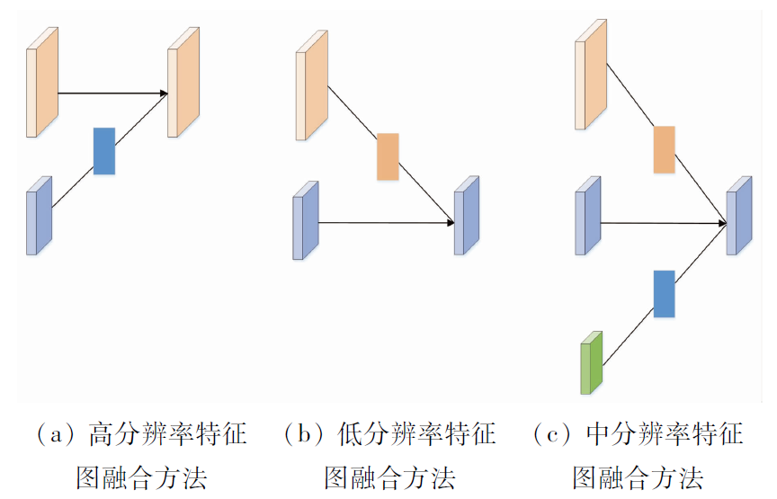
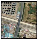
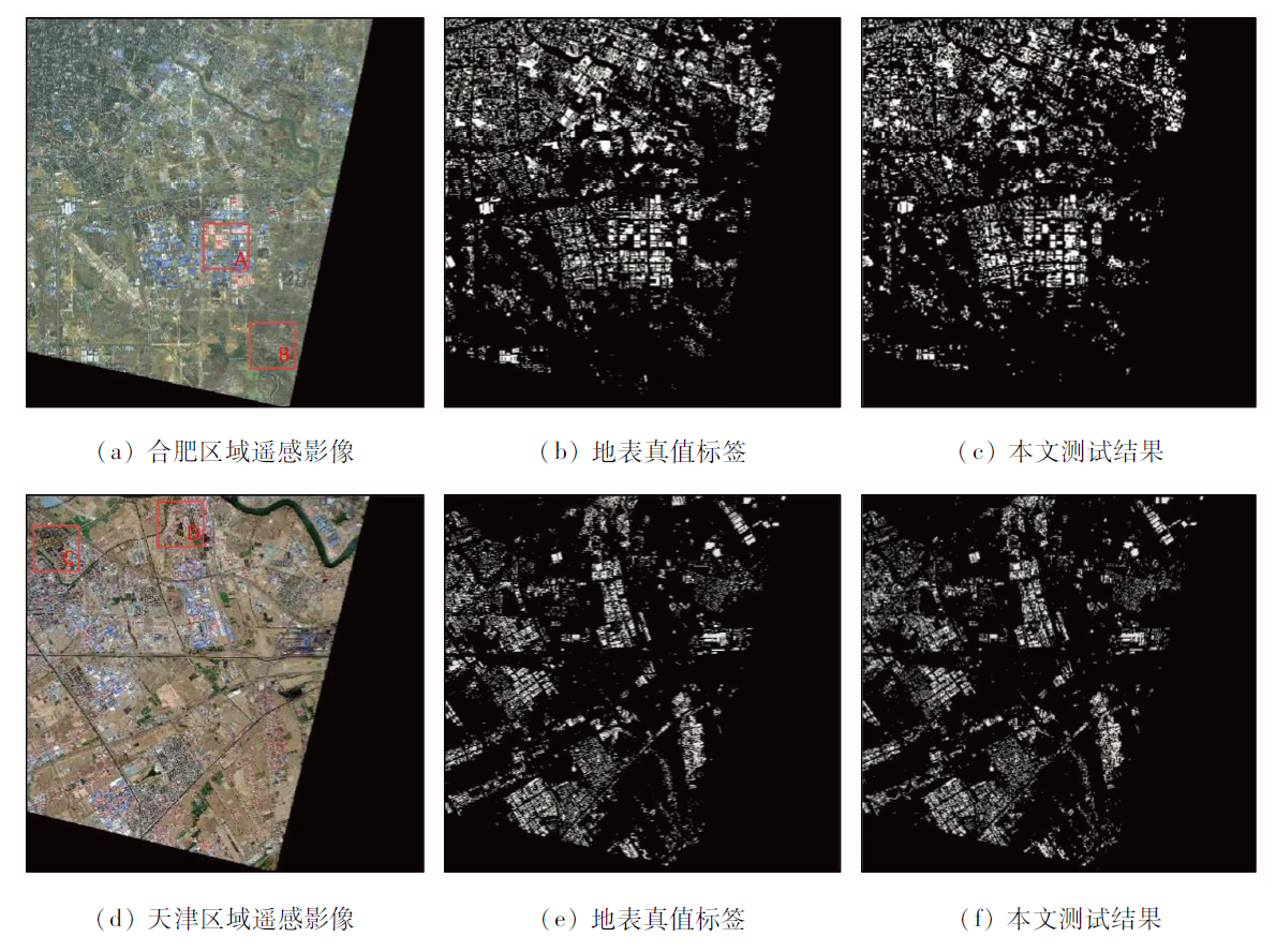
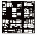
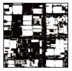
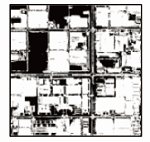
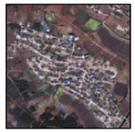
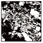
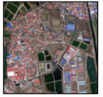
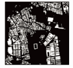
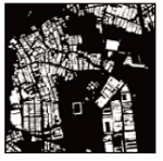
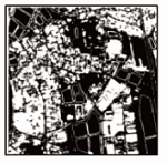
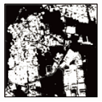
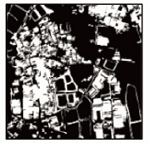
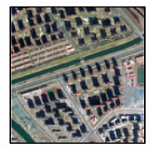
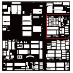
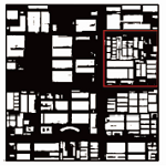
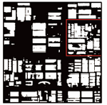
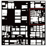
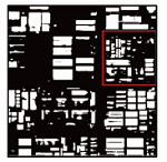
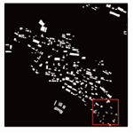
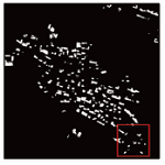
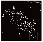
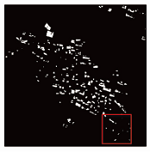
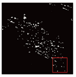
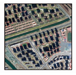
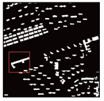
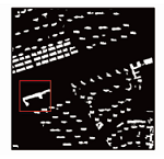
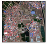
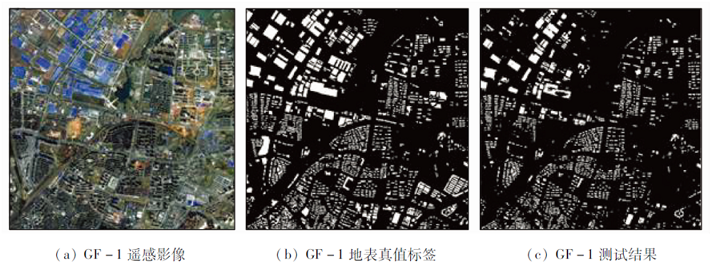
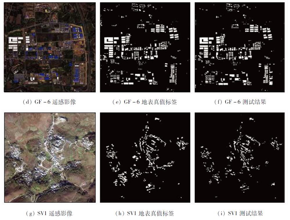
Abstract The task of extracting buildings with high-resolution remote sensing image plays an important role in urban planning and urbanization. In view of the problems of existing deep learning extraction methods, for example, the shallow features can’t been used effectively and small target information is easily lost, this paper proposes a multi-level perceptual network. This network uses dense connection mechanism to fully extract feature information, and constructs parallel structure to retain spatial information of different feature resolution and enhance feature information of different depth and scale in order to reduce the loss of detail feature. At the same time, the ASPP module is used to obtain the information of different receptive fields and extract the deep architectural features at different scales. The experimental results show that the overall accuracy of the proposed method is 97.19%, intersection over union is 74.33% and theF1 score is 85.43% in the buildings extraction of GF-2 remote sensing image, all of which are higher than those of the traditional method and other deep learning methods. In addition, buildings with multi-source remote sensing images still have good extraction effect, which reflects the practicability of the method presented in this paper.
|
| Keywords
deep learning
remote sensing images
building extraction
multiscale feature fusion
|
|
|
|
Corresponding Authors:
WU Yanlan
E-mail: luqi9507@163.com;wuyanlan@ahu.edu.cn
|
|
Issue Date: 21 July 2021
|
|
|
| [1] |
于嘉. 基于特征提取的北方乡村景观建筑物层次化布局研究[J]. 科技通报, 2019, 35(1):147-150.
|
| [1] |
Yu J. Research on hierarchical distribution of buildings in northern rural landscape based on feature extraction[J]. Bulletin of Science and Technology, 2019, 35(1):147-150.
|
| [2] |
Luis M, Luis M P, Erick M, et al. Novel unsupervised classification of collapsed buildings using satellite imagery,hazard scenarios and fragility functions[J]. Remote Sensing, 2018, 10(2):296.
doi: 10.3390/rs10020296
url: http://www.mdpi.com/2072-4292/10/2/296
|
| [3] |
刘焕军, 杨昊轩, 徐梦园, 等. 基于裸土期多时相遥感影像特征及最大似然法的土壤分类[J]. 农业工程学报, 2018, 34(14):132-139.
|
| [3] |
Liu H J, Yang H X, Xu M Y. Soil classification based on maximum likelihood method and features of multitemporal remote sensing images in bare soil period[J]. Transactions of the Chinese Society of Agricultural Engineering, 2018, 34(14):132-139.
|
| [4] |
张浩, 赵云胜, 陈冠宇, 等. 基于支持向量机的遥感图像建筑物识别与分类方法研究[J]. 地质科技情报, 2016(6):200-205.
|
| [4] |
Zhang H, Zhao Y S, Chen G Y. Remote sensing image building recognition and classification based on the support vector machine[J]. Geological Science and Technology Information, 2016(6):200-205.
|
| [5] |
李强, 张景发. 基于CART决策树提取高分辨率遥感影像建筑物信息[J]. 地震, 2013, 33(2):96-102.
|
| [5] |
Li Q, Zhang J F. Extraction of building information from high resolution images based on CART decision tree[J]. Earthquake, 2013, 33(2):96-102.
|
| [6] |
于书媛, 骆佳骥, 杨源源. 基于高分卫星遥感影像的城市建筑物提取研究[J]. 华南地震, 2019, 39(2):26-33.
|
| [6] |
Yu S Y, Luo J J, Yang Y Y. Research on extraction of urban buildings based on high satellite remote sensing images[J]. South China Journal of Seismology, 2019, 39(2):26-33
|
| [7] |
王崇倡, 武文波, 张建平. 基于BP神经网络的遥感影像分类方法[J]. 辽宁工程技术大学学报(自然科学版), 2009, 28(1):32-35.
|
| [7] |
Wang C C, Wu W B, Zhang J P. Classification for remote sensing image based on BP neural network[J]. Journal of Liaoning Technical University(Natural Science), 2009, 28(1):32-35.
|
| [8] |
Shackelford A K, Davis C H. A combined fuzzy pixel-based and object-based approach for classification of high-resolution multispectral data over urban areas[J]. IEEE Transactions on Geoscience & Remote Sensing, 2003, 41(10):2354-2363.
|
| [9] |
Hofmann P. Detecting informal settlements from IKONOS image data using methods of object oriented image analysis:An example from Cape Town (South Africa)[M]. Jürgens C.Remote Sensing of Urban Areas/Fernerkundung in Urbanen Räumen, 2001:41-42.
|
| [10] |
陶超, 谭毅华, 蔡华杰, 等. 面向对象的高分辨率遥感影像城区建筑物分级提取方法[J]. 测绘学报, 2010, 39(1):39-45.
|
| [10] |
Tao C, Tan Y H, Cai H J, et al. Objectoriented method of hierarchical urban building extraction from high-resolution remotesensing imagery[J]. Acta Geodaetica et Cartographica Sinica, 2010, 39(1):39-45.
|
| [11] |
邓瑞, 林金朝, 杨宏志. 基于深度学习的建筑物识别[J]. 重庆工商大学学报(自然科学版), 2019(4):17-22.
|
| [11] |
Deng R, Lin J C, Yang H Z. Building identification based on deep learning[J]. Chongqing Technology & Business University(Natural Science), 2019(4):17-22.
|
| [12] |
Alshehhi R, Marpu P R, Woon W L, et al. Simultaneous extraction of roads and buildings in remote sensing imagery with convolutional neural networks[J]. ISPRS Journal of Photogrammetry & Remote Sensing, 2017, 130:139-149.
|
| [13] |
Mnih V. Machine learning for aerial image labeling[D]. Toronto:University of Toronto, 2013.
|
| [14] |
杨建宇, 周振旭, 杜贞容, 等. 基于SegNet语义模型的高分辨率遥感影像农村建设用地提取[J]. 农业工程学报, 2019, 35(5):259-266.
|
| [14] |
Yang J Y, Zhou Z X, Du Z R, et al. Rural construction land extraction from high spatial resolution remote sensing image based on SegNet semantic segmentation model[J]. Transactions of the Chinese Society of Agricultural Engineering, 2019, 35(5):259-266.
|
| [15] |
吕道双. 一种改进型U-Net遥感影像建筑物提取[J]. 测绘, 2019, 42(5):231-234.
|
| [15] |
Lyu D S. An improved U-Net remote sensing image building extraction[J]. Surveying Mapping, 2019, 42(5):231-234.
|
| [16] |
Yi Y, Zhang Z, Zhang W, et al. Semantic segmentation of urban buildings from VHR remote sensing imagery using a deep convolutional neural network[J]. Remote Sensing, 2019, 11(15):1774.
doi: 10.3390/rs11151774
url: https://www.mdpi.com/2072-4292/11/15/1774
|
| [17] |
Huang Z, Cheng G, Wang H, et al. Building extraction from multi-source remote sensing images via deep deconvolution neural networks[C]// Geoscience & Remote Sensing Symposium.IEEE, 2016.
|
| [18] |
Feng W, Sui H, Hua L, et al. Improved deep fully convolutional network with superpixel-based conditional random fields for building extraction[C]// 2019 IEEE International Geoscience and Remote Sensing Symposium.IEEE, 2019.
|
| [19] |
Liu P, Liu X, Liu M, et al. Building footprint extraction from high-resolution images via spatial residual inception convolutional neural network[J]. Remote Sensing, 2019, 11(7):830.
doi: 10.3390/rs11070830
url: https://www.mdpi.com/2072-4292/11/7/830
|
| [20] |
徐胜军, 欧阳朴衍, 郭学源. 多尺度特征融合空洞卷积ResNet遥感图像建筑物分割[J]. 光学精密工程, 2020, 28(7):1588-1599.
|
| [20] |
Xu S J, Ouyang P Y, Guo X Y. Building segmentation in remote sensing image based on multiscale-feature fusion dilated convolution resnet[J]. Optics and Precision Engineering, 2020, 28(7):1588-1599.
|
| [21] |
Sun K, Xiao B, Liu D, et al. Deep high-resolution representation learning for human pose estimation[C]// 2019 IEEE/CVF Conference on Computer Vision and Pattern Recognition (CVPR).arXiv, 2019.
|
| [22] |
Huang J, Zhu Z, Huang G. Multi-stage HRNet:Multiple stage high-resolution network for human pose estimation[EB/OL]. ( 2019- 10- 14)[2021- 01- 07]. http://arxiv.org/abs/1910.05901.
url: http://arxiv.org/abs/1910.05901
|
| [23] |
Yang H, Wu P, Yao X, et al. Building extraction in very high resolution imagery by dense-attention networks[J]. Remote Sensing, 2018, 10(11):1768.
doi: 10.3390/rs10111768
url: http://www.mdpi.com/2072-4292/10/11/1768
|
| [24] |
蒋应锋, 张桦, 薛彦兵, 等. 一种新的多尺度深度学习图像语义理解方法研究[J]. 光电子·激光, 2016(2):224-230.
|
| [24] |
Jiang Y F, Zhang H, Xue Y B, et al. A new multiscale image semantic understanding method based on deep learning[J]. Journal of Optoelectronics Laser, 2016(2):224-230.
|
| [25] |
Huang G, Liu Z, Laurens V D M, et al. Densely connected convolutional networks[C]// Proceedings of the IEEE Conference on Computer Vision and Pattern Recognition (CVPR),Honolulu:IEEE, 2017:2261-2269
|
| [26] |
Yao X, Yang H, Wu Y, et al. Land use classification of the deep convolutional neural network method reducing the loss of spatial features[J]. Sensors, 2019, 19(12):2792.
doi: 10.3390/s19122792
url: https://www.mdpi.com/1424-8220/19/12/2792
|
| [27] |
Chen L C, Zhu Y, Papandreou G, et al. Encoder-decoder with atrous separable convolution for semantic image segmentation[C]// Computer Vision-ECCV 2018.Munich:Springer, 2018:833-851.
|
| [28] |
Chen L C, Papandreou G, Kokkinos I, et al. DeepLab:Semantic image segmentation with deep convolutional nets,atrous convolution,and fully connected CRFs[J]. IEEE Transactions on Pattern Analysis and Machine Intelligence, 2018, 40(4):834-848.
doi: 10.1109/TPAMI.2017.2699184
url: http://ieeexplore.ieee.org/document/7913730/
|
| [29] |
Awrangjeb M, Fraser C S. An automatic and threshold-free performance evaluation system for building extraction techniques from airborne LiDAR data[J]. IEEE Journal of Selected Topics in Applied Earth Observations & Remote Sensing, 2014, 7(10):4184-4198.
|
| [30] |
Yu C, Wang J, Peng C, et al. BiSeNet:Bilateral segmentation network for real-time semantic segmentation[EB/OL]. ( 2018- 08- 02) [2021- 01- 07]. http://arxiv.org/abs/1808.00897.
url: http://arxiv.org/abs/1808.00897
|
| [31] |
杜一民, 戴激光. 利用高程信息结合彩色遥感航空影像提取建筑物目标[J]. 测绘与空间地理信息, 2019(7):125-127.
|
| [31] |
Du Y M, Dai J G. Using elevation information to combine color remote sensing aerial images extraction of building targets[J]. Geomatics & Spatial information Technology, 2019(7):125-127.
|
|
Viewed |
|
|
|
Full text
|
|
|
|
|
Abstract
|
|
|
|
|
Cited |
|
|
|
|
| |
Shared |
|
|
|
|
| |
Discussed |
|
|
|
|
 2021,
Vol. 33
2021,
Vol. 33