|
|
|
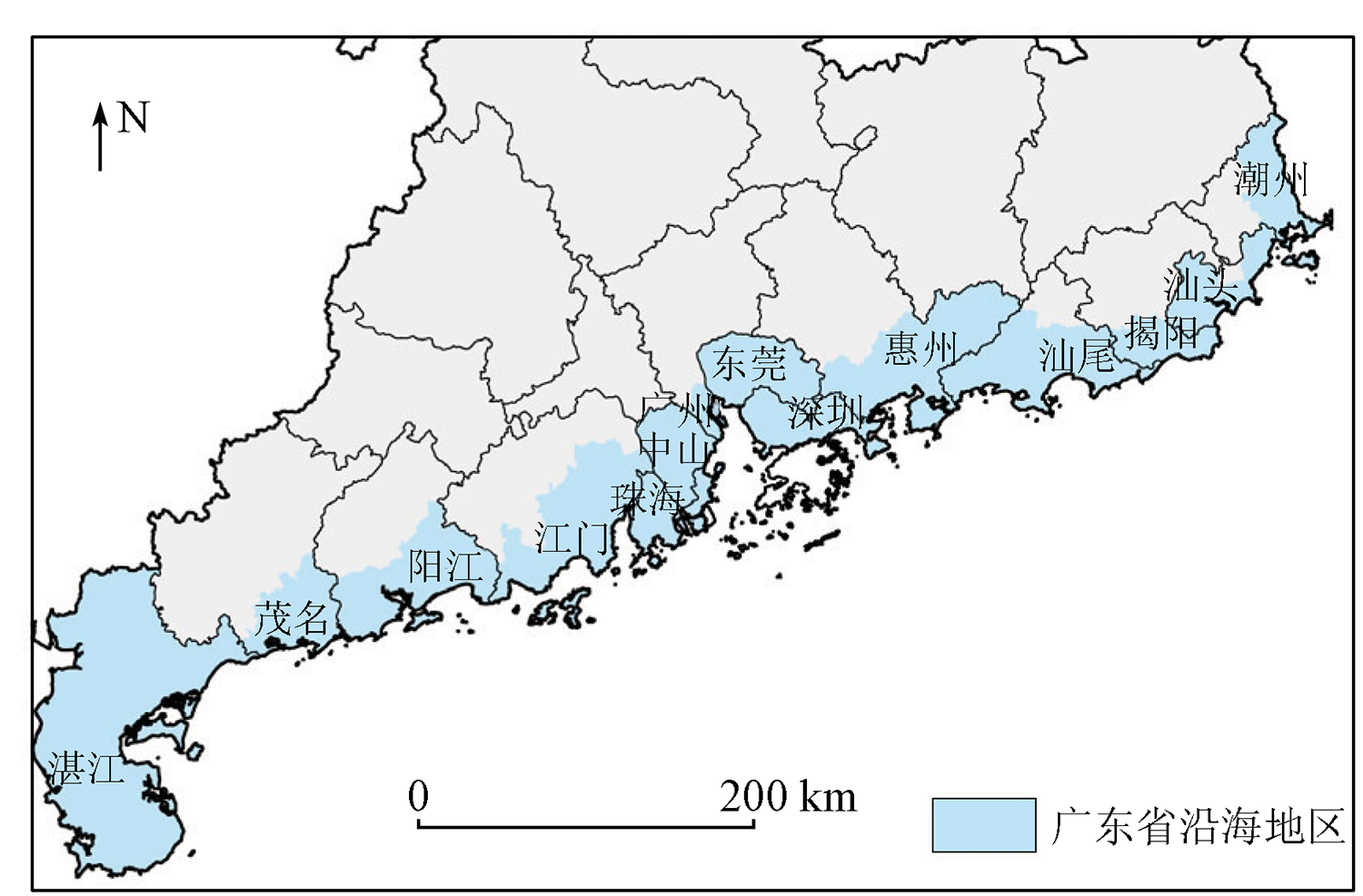
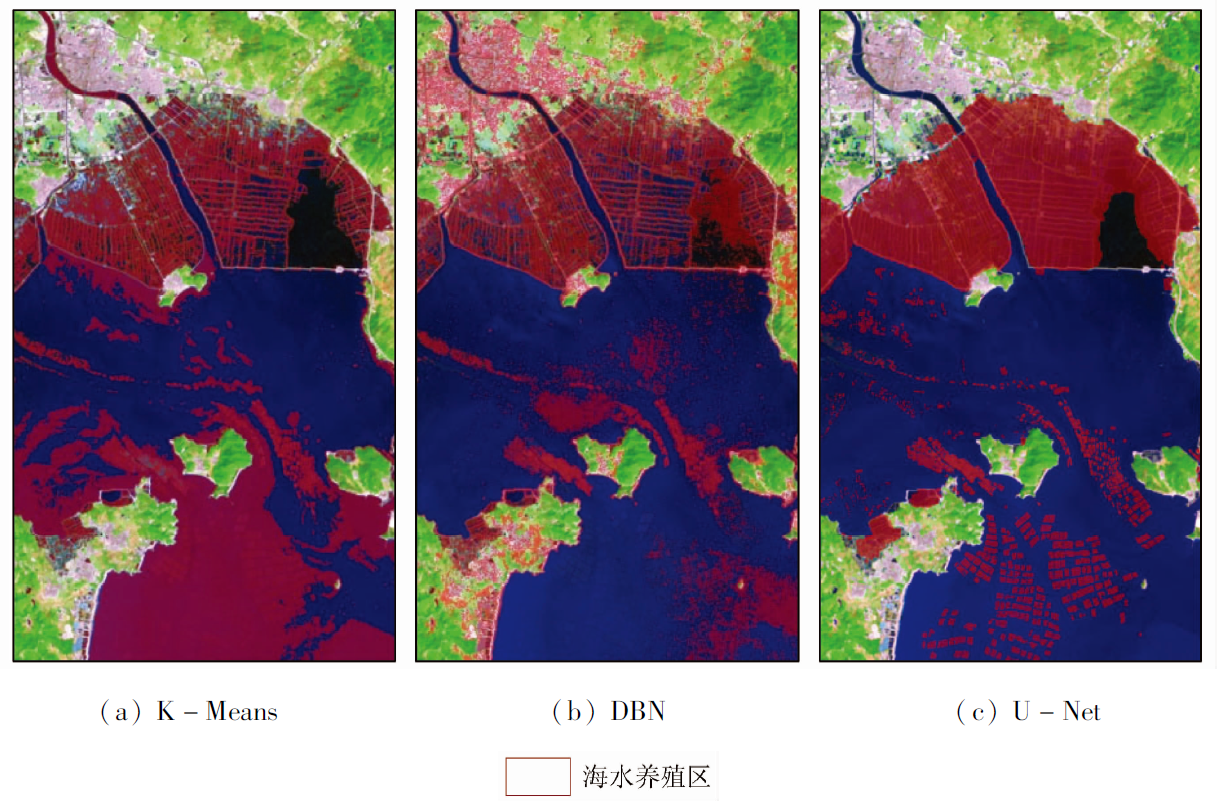
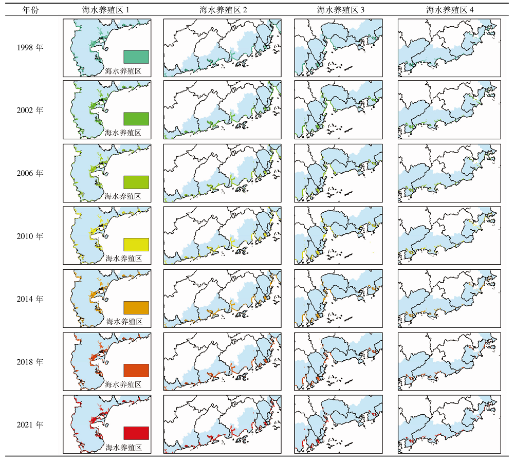
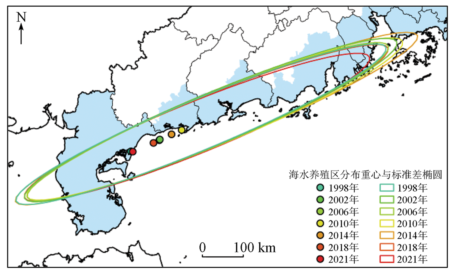
Abstract The mariculture industry occupies an important position in the marine economy of Guangdong Province. Timely and accurate knowledge of the spatial distribution and area changing trends of mariculture areas can greatly promote the sustainable development of the mariculture industry. Conventional interpretation methods for remote sensing images have problems of poor repeatability, low applicability, and high subjective arbitrariness. By contrast, the U-Net convolutional neural network, which belongs to the deep learning network model, can better extract the features of the object with higher extraction precision. Therefore, based on the multi-temporal Landsat TM/OLI remote sensing images, this study identified the mariculture areas (enclosed-sea and open-cage aquaculture areas) in Guangdong from 1998 to 2021 using the U-Net model as the interpretation model. The area trend analysis of mariculture areas was made. The changing characteristics of mariculture areas in terms of spatial distribution patterns were studied. The results are as follows. Compared with network models such as K-Means cluster analysis and DBN, the U-Net model with higher interpretation precision is more suitable for the interpretation of mariculture areas in Guangdong. The mariculture areas in Guangdong are mainly distributed in the western portion of Guangdong, such as Zhanjiang, Jiangmen, and Yangjiang. The mariculture areas in Guangdong can be classified into three levels in terms of area. They have small changes and keep a relatively stable state. The mariculture areas in Guangdong showed a spatial trend of outward expansion from 1998 to 2014 and inward contraction from 2014 to 2021. This study will provide data and technical support for the scientific management of the mariculture areas in Guangdong.
|
| Keywords
mariculture area
remote sensing
deep learning
U-Net model
Guangdong Province
|
|
|
|
Issue Date: 27 December 2022
|
|
|
| [1] |
杨正勇, 刘东, 彭乐威. 中国海水养殖业绿色发展:水平测度、区域对比及发展对策研究[J]. 生态经济, 2021, 37(11):128-135.
|
| [1] |
Yang Z Y, Liu D, Peng L W. Green development of mariculture in China:Estimation,regional comparison and research on development strategy[J]. Ecological Economy, 2021, 37(11):128-135.
|
| [2] |
黄文积, 袁蓓. 高质量发展要求下我国海水养殖业竞争力评价[J]. 中国渔业经济, 2021, 39(4):60-67.
|
| [2] |
Huang W J, Yuan B. Competitiveness evaluation of China’s mariculture industry under the requirements of high-quality development[J]. Chinese Fisheries Economics, 2021, 39(4):60-67.
|
| [3] |
翟路, 孙兆群, 王波, 等. 基于灰色预测模型的我国海洋渔业发展趋势研究[J]. 江苏农业科学, 2019, 47(13):342-346.
|
| [3] |
Zhai L, Sun Z Q, Wang B, et al. Study on development of China’s marine fisheries based on GM (1,1) model[J]. Jiangsu Agricultural Sciences, 2019, 47(13):342-346.
|
| [4] |
郑智腾, 范海生, 王洁, 等. 改进型双支网络模型的遥感海水网箱养殖区智能提取方法[J]. 国土资源遥感, 2020, 32(4):120-129.doi:10.6046/gtzyyg.2020.04.17.
doi: 10.6046/gtzyyg.2020.04.17
|
| [4] |
Zheng Z T, Fan H S, Wang J, et al. An improved double-branch network method for intelligently extracting marinecage culture area[J]. Remote Sensing for Land and Resources, 2020, 32(4):120-129.doi:10.6046/gtzyyg.2020.04.17.
doi: 10.6046/gtzyyg.2020.04.17
|
| [5] |
Oyinlola M A, Reygondeau G, Wabnitz C C C, et al. Global estimation of areas with suitable environmental conditions for mariculture species[J]. PLoS One, 2018, 13(1):e191086.
|
| [6] |
Feng Z H, Zhang T, Wang J X, et al. Spatio-temporal features of microplastics pollution in macroalgae growing in an important mariculture area,China[J]. Science of the Total Environment, 2020, 719:137490.
doi: 10.1016/j.scitotenv.2020.137490
url: https://linkinghub.elsevier.com/retrieve/pii/S0048969720310019
|
| [7] |
武易天, 陈甫, 马勇, 等. 基于Landsat8数据的近海养殖区自动提取方法研究[J]. 国土资源遥感, 2018, 30(3):96-105.doi:10.6046/gtzyyg.2018.03.14.
doi: 10.6046/gtzyyg.2018.03.14
|
| [7] |
Wu Y T, Chen F, Ma Y, et al. Research on automatic extraction method for coastal aquaculture area using Landsat8 data[J]. Remote Sensing for Land and Resources, 2018, 30(3):96-105.doi:10.6046/gtzyyg.2018.03.14.
doi: 10.6046/gtzyyg.2018.03.14
|
| [8] |
杨智威, 陈颖彪, 吴志峰, 等. 基于自然区块的城市热环境空间分异性研究[J]. 地理科学进展, 2019, 38(12):1944-1956.
doi: 10.18306/dlkxjz.2019.12.010
|
| [8] |
Yang Z W, Chen Y B, Wu Z F, et al. Spatial variability of urban thermal environment based on natural blocks[J]. Progress in Geography, 2019, 38(12):1944-1956.
doi: 10.18306/dlkxjz.2019.12.010
|
| [9] |
李阳, 袁琳, 赵志远, 等. 基于无人机低空遥感和现场调查的潮滩地形反演研究[J]. 自然资源遥感, 2021, 33(3):80-88.doi:10.6046/zrzyyg.2020336.
doi: 10.6046/zrzyyg.2020336
|
| [9] |
Li Y, Yuan L, Zhao Z Y, et al. Inversion of tidal flat topography based on unmanned aerial vehicle low-altitude remote sensing and field surveys[J]. Remote Sensing for Natural Resources, 2021, 33(3):80-88.doi:10.6046/zrzyyg.2020336.
doi: 10.6046/zrzyyg.2020336
|
| [10] |
徐京萍, 赵建华, 张丰收, 等. 面向对象的池塘养殖用海信息提取[J]. 国土资源遥感, 2013, 25(1):82-85.doi:10.6046/gtzyyg.2013.01.15.
doi: 10.6046/gtzyyg.2013.01.15
|
| [10] |
Xu J P, Zhao J H, Zhang F S, et al. Object-oriented information extraction of pond aquaculture[J]. Remote Sensing for Land and Resources, 2013, 25(1):82-85.doi:10.6046/gtzyyg.2013.01.15.
doi: 10.6046/gtzyyg.2013.01.15
|
| [11] |
Wang Z H, Yang X M, Liu Y M, et al. Extraction of coastal raft cultivation area with heterogeneous water background by thresholding object-based visually salient NDVI from high spatial resolution imagery[J]. Remote Sensing Letters, 2018, 9(9):839-846.
doi: 10.1080/2150704X.2018.1468103
url: https://www.tandfonline.com/doi/full/10.1080/2150704X.2018.1468103
|
| [12] |
陈思明. 三沙湾海水养殖区时空动态变化及其影响因素[J]. 生态学杂志, 2021, 40(4):1137-1145.
|
| [12] |
Chen S M. Spatiotemporal dynamics of mariculture area in Sansha Bay and its driving factors[J]. Chinese Journal of Ecology, 2021, 40(4):1137-1145.
|
| [13] |
王芳, 夏丽华, 陈智斌, 等. 基于关联规则面向对象的海岸带海水养殖模式遥感识别[J]. 农业工程学报, 2018, 34(12):210-217.
|
| [13] |
Wang F, Xia L H, Chen Z B, et al. Remote sensing identification of coastal zone mariculture modes based on association-rules object-oriented method[J]. Transactions of the Chinese Society of Agricultural Engineering, 2018, 34(12):210-217.
|
| [14] |
Lu Y M, Shao W, Sun J. Extraction of offshore aquaculture areas from medium-resolution remote sensing images based on deep learning[J]. Remote Sensing, 2021, 13(19):3854.
doi: 10.3390/rs13193854
url: https://www.mdpi.com/2072-4292/13/19/3854
|
| [15] |
Alom M Z, Yakopcic C, Hasan M, et al. Recurrent residual U-Net for medical image segmentation[J]. Journal of Medical Imaging, 2019, 6(1):014006.
|
| [16] |
Wei S S, Zhang H, Wang C, et al. Multi-temporal SAR data large-scale crop mapping based on U-Net model[J]. Remote Sensing, 2019, 11(1):68.
doi: 10.3390/rs11010068
url: https://www.mdpi.com/2072-4292/11/1/68
|
| [17] |
Cui B G, Fei D, Shao G H, et al. Extracting raft aquaculture areas from remote sensing images via an improved U-Net with a PSE structure[J]. Remote Sensing, 2019, 11(17):2053.
doi: 10.3390/rs11172053
url: https://www.mdpi.com/2072-4292/11/17/2053
|
| [18] |
Falk T, Mai D, Bensch R, et al. U-Net:Deep learning for cell counting,detection,and morphometry[J]. Nature Methods, 2019, 16(1):67-70.
doi: 10.1038/s41592-018-0261-2
url: https://doi.org/10.1038/s41592-018-0261-2
|
| [19] |
杨瑞, 祁元, 苏阳. 深度学习U-Net方法及其在高分辨卫星影像分类中的应用[J]. 遥感技术与应用, 2020, 35(4):767-774.
|
| [19] |
Yang R, Qi Y, Su Y. U-Net neural networks and its application in high resolution satellite image classification[J]. Remote Sensing Technology and Application, 2020, 35(4):767-774.
|
| [20] |
杨智威, 陈颖彪, 千庆兰, 等. 人口空间化下公共医疗服务水平匹配度评价——以广州市为例[J]. 地理与地理信息科学, 2019, 35(2):74-82.
|
| [20] |
Yang Z W, Chen Y B, Qian Q L, et al. Evaluation of the matching degree of public medical service level based on population spatialization:A case study of Guangzhou[J]. Geography and Geo-Information Science, 2019, 35(2):74-82.
|
| [21] |
Nogueira K, Penatti O A B, Dos S J A. Towards better exploiting convolutional neural networks for remote sensing scene classification[J]. Pattern Recognition, 2017, 61:539-556.
doi: 10.1016/j.patcog.2016.07.001
url: https://linkinghub.elsevier.com/retrieve/pii/S0031320316301509
|
| [22] |
Shao Z F, Zhou W X, Deng X Q, et al. Multilabel remote sensing image retrieval based on fully convolutional network[J]. IEEE Journal of Selected Topics in Applied Earth Observations and Remote Sensing, 2020, 13:318-328.
doi: 10.1109/JSTARS.2019.2961634
url: https://ieeexplore.ieee.org/document/8954885/
|
| [23] |
Freudenberg M, Nölke N, Agostini A, et al. Large-scale palm tree detection in high resolution satellite images using U-Net[J]. Remote Sensing, 2019, 11(3):312.
doi: 10.3390/rs11030312
url: http://www.mdpi.com/2072-4292/11/3/312
|
| [24] |
Qin P, Cai Y L, Wang X L. Small waterbody extraction with improved U-Net using Zhuhai-1 hyperspectral remote sensing images[J]. IEEE Geoscience and Remote Sensing Letters, 2020, 19:1-5.
|
| [25] |
Liu Z Q, Cao Y W, Wang Y Z, et al. Computer vision-based concrete crack detection using U-Net fully convolutional networks[J]. Automation in Construction, 2019, 104:129-139.
doi: 10.1016/j.autcon.2019.04.005
url: https://linkinghub.elsevier.com/retrieve/pii/S0926580519301244
|
| [26] |
Zhang Z, Wu C D, Coleman S, et al. DENSE-Inception U-Net for medical image segmentation[J]. Computer Methods and Programs in Biomedicine, 2020, 192:105395.
doi: 10.1016/j.cmpb.2020.105395
url: https://linkinghub.elsevier.com/retrieve/pii/S0169260719307904
|
| [27] |
Ibtehaz N, Rahman M S. MultiResUNet:Rethinking the U-Net architecture for multimodal biomedical image segmentation[J]. Neural Networks, 2020, 121:74-87.
doi: S0893-6080(19)30250-3
pmid: 31536901
|
| [28] |
杨智威, 陈颖彪, 郑子豪, 等. 广东省A级旅游点空间分布特征与可达性测度[J]. 地理空间信息, 2019, 17(6):51-55.
|
| [28] |
Yang Z W, Chen Y B, Zheng Z H, et al. Spatial accessibility and spatial distribution characteristics of A-grade tourist spots in Guangdong Province[J]. Geospatial Information, 2019, 17(6):51-55.
|
|
Viewed |
|
|
|
Full text
|
|
|
|
|
Abstract
|
|
|
|
|
Cited |
|
|
|
|
| |
Shared |
|
|
|
|
| |
Discussed |
|
|
|
|
 2022,
Vol. 34
2022,
Vol. 34
 ), LIN Yangyang1, YUE Wen1(