|
|
 |
|

|
|
|
Urban expansion in the Changsha-Zhuzhou-Xiangtan urban agglomeration and its urban heat island effect from 2000 to 2018 |
YAO Lingyun1,2( ), WANG Li1, NIU Zheng1,2, YIN Ziqi1,2, FU Yuwen1,2 ), WANG Li1, NIU Zheng1,2, YIN Ziqi1,2, FU Yuwen1,2 |
1. State Key Laboratory of Remote Sensing Science, Aerospace Information Research Institute, Chinese Academy of Sciences, Beijing 100094, China
2. University of Chinese Academy of Science, Beijing 100049, China |
|
|
|
|
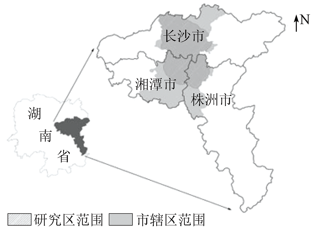
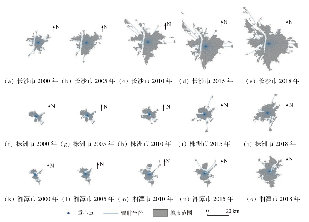
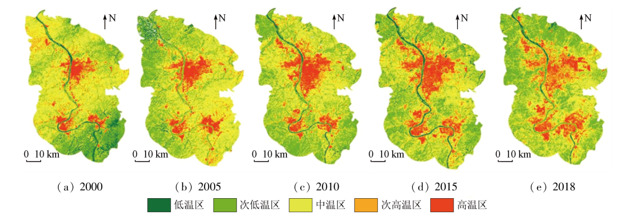
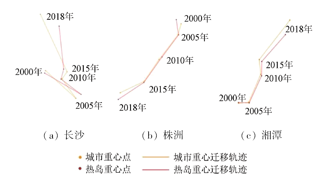
Abstract The urban heat island effect is closely linked with the well-being of urban residents. Rapid urbanization has further accelerated urban expansion. This is accompanied by an increasingly significant urban heat island effect, especially in cities of central and western China in the past 20 years. To explore the relationship between the expansion of cities and urban agglomerations and the changes in the urban heat island effect, this study analyzed the expansion and spatial form variation of cities in the Changsha-Zhuzhou-Xiangtan urban agglomeration using the Boyce-Clark shape index. The land surface temperatures were derived through inversion using the practical single-channel algorithm based on the Google Earth Engine (GEE) platform. The temperature zones with different grades were determined using the mean-standard deviation method, followed by the definition and extraction of the range of the urban heat island effect. The urban center and heat island center were extracted, and the variation trends of the relationship between urban expansion and urban heat island effect were analyzed using the center shift method. The results show that the changes in the urban heat island effect were consistent with the expansion of the urban agglomeration and its cities. The results lead to the following conclusions: ① After 2015, the Changsha-Zhuzhou-Xiangtan urban agglomeration entered a critical period of rapid development; ② Urban expansion is the primary cause of the increase in the area of urban heat island effect; ③ The urban heat island center roughly shares the same variation trend with the urban center, and the urban heat island range increases in the direction roughly consistent with the urban expansion direction.
|
| Keywords
urban heat island effect
urban spatial form
land surface temperature
Boyce-Clark shape index
center of gravity shift
|
|
|
|
Issue Date: 13 March 2024
|
|
|
| [1] |
肖荣波, 欧阳志云, 李伟峰, 等. 城市热岛的生态环境效应[J]. 生态学报, 2005, 25(8):2055-2060.
|
| [1] |
Xiao R B, Ouyang Z Y, Li W F, et al. A review of the eco-environmental consequences of urban heat islands[J]. Acta Ecologica Sinica, 2005, 25(8):2055-2060.
|
| [2] |
Li D, Bou-Zeid E. Synergistic Interactions between urban heat islands and heat waves:The impact in cities is larger than the sum of its parts[J]. Journal of Applied Meteorology and Climatology, 2013, 52(9):2051-2064.
doi: 10.1175/JAMC-D-13-02.1
url: https://journals.ametsoc.org/view/journals/apme/52/9/jamc-d-13-02.1.xml
|
| [3] |
谢苗苗, 王仰麟, 付梅臣. 城市地表温度热岛影响因素研究进展[J]. 地理科学进展, 2011, 30(1):35-41.
|
| [3] |
Xie M M, Wang Y L, Fu M C. An overview and perspective about causative factors of surface urban heat island effects[J]. Progress in Geography, 2011, 30(1):35-41.
doi: 10.11820/dlkxjz.2011.01.004
|
| [4] |
江颂, 彭建, 董建权, 等. 地表城市热岛效应的概念内涵与定量刻画[J]. 地理学报, 2022, 77(9):2249-2265.
doi: 10.11821/dlxb202209008
|
| [4] |
Jiang S, Peng J, Dong J Q, et al. Conceptual connotation and quantitative characterization of surface urban heat island effect[J]. Acta Geographica Sinica, 2022, 77(9):2249-2265.
doi: 10.11821/dlxb202209008
|
| [5] |
陈爱莲, 孙然好, 陈利顶. 基于景观格局的城市热岛研究进展[J]. 生态学报, 2012, 32(14):4553-4565.
|
| [5] |
Chen A L, Sun R H, Chen L D. Studies on urban heat island from a landscape pattern view:A review[J]. Acta Ecologica Sinica, 2012, 32(14):4553-4565.
doi: 10.5846/stxb
url: http://www.ecologica.cn/
|
| [6] |
胡楠林, 任志彬, 董禹麟, 等. 中国城市群热岛效应时空演变及其影响因素分析[J]. 地理科学, 2022, 42(9):1534-1545.
doi: 10.13249/j.cnki.sgs.2022.09.003
|
| [6] |
Hu N L, Ren Z B, Dong Y L, et al. Spatio-temporal evolution of heat island effect and its driving factors in urban agglomerations of China[J]. Scientia Geographica Sinica, 2022, 42(9):1534-1545.
doi: 10.13249/j.cnki.sgs.2022.09.003
|
| [7] |
Tian P, Li J L, Cao L D, et al. Assessing spatiotemporal characteristics of urban heat islands from the perspective of an urban expansion and green infrastructure[J]. Sustainable Cities and Society, 2021, 74: 103208.
doi: 10.1016/j.scs.2021.103208
url: https://linkinghub.elsevier.com/retrieve/pii/S2210670721004868
|
| [8] |
Nurwanda A, Honjo T. Analysis of land use change and expansion of surface urban heat island in Bogor city by remote sensing[J]. ISPRS International Journal of Geo-Information, 2018, 7(5):165.
doi: 10.3390/ijgi7050165
url: http://www.mdpi.com/2220-9964/7/5/165
|
| [9] |
Gao Z, Hou Y, Chen W P. Enhanced sensitivity of the urban heat island effect to summer temperatures induced by urban expansion[J]. Environmental Research Letters, 2019, 14(9):094005.
doi: 10.1088/1748-9326/ab2740
|
| [10] |
Zhou D C, Xiao J F, Bonafoni S, et al. Satellite remote sensing of surface urban heat islands:Progress,challenges,and perspectives[J]. Remote Sensing, 2018, 11(1):48.
doi: 10.3390/rs11010048
url: http://www.mdpi.com/2072-4292/11/1/48
|
| [11] |
黄群芳. 城市空间形态对城市热岛效应的多尺度影响研究进展[J]. 地理科学, 2021, 41(10):1832-1842.
doi: 10.13249/j.cnki.sgs.2021.10.015
|
| [11] |
Huang Q F. Effects of urban spatial morphology on urban heat island effect from multi-spatial scales perspectives[J]. Scientia Geographica Sinica, 2021, 41(10):1832-1842.
doi: 10.13249/j.cnki.sgs.2021.10.015
|
| [12] |
Zhao M Y, Cai H Y, Qiao Z, et al. Influence of urban expansion on the urban heat island effect in Shanghai[J]. International Journal of Geographical Information Science, 2016, 30(12):2421-2441.
doi: 10.1080/13658816.2016.1178389
url: https://www.tandfonline.com/doi/full/10.1080/13658816.2016.1178389
|
| [13] |
Tu L L, Qin Z H, Li W J, et al. Surface urban heat island effect and its relationship with urban expansion in Nanjing,China[J]. Journal of Applied Remote Sensing, 2016, 10(2):026037.
doi: 10.1117/1.JRS.10.026037
url: http://remotesensing.spiedigitallibrary.org/article.aspx?doi=10.1117/1.JRS.10.026037
|
| [14] |
湖南省统计局. 湖南统计年鉴[M]. 北京: 中国统计出版社, 2021.
|
| [14] |
Hunan Provincial Bureau of Statistics. Hunan Statistical Yearbook[M]. Beijing: China Statistics Press, 2021.
|
| [15] |
Li X C, Gong P, Zhou Y Y, et al. Mapping global urban boundaries from the global artificial impervious area (GAIA) data[J]. Environmental Research Letters, 2020, 15(9):094044.
doi: 10.1088/1748-9326/ab9be3
|
| [16] |
Boyce R R, Clark W A V. The concept of shape in geography[J]. Geographical Review, 1964, 54(4):561-572.
doi: 10.2307/212982
url: https://www.jstor.org/stable/212982?origin=crossref
|
| [17] |
熊皓, 郑伯红, 贾磊. 驱动力与制约力相互作用下我国城市空间扩张[J]. 经济地理, 2016, 36(1):82-88.
|
| [17] |
Xiong H, Zheng B H, Jia L. Urban space expansion in China under the interaction between the driving force and the restriction[J]. Economic Geography, 2016, 36(1):82-88.
|
| [18] |
王新生, 刘纪远, 庄大方, 等. 中国城市形状的时空变化[J]. 资源科学, 2005, 27(3):20-25.
|
| [18] |
Wang X S, Liu J Y, Zhuang D F, et al. Spatial-temporal changes of the shapes of Chinese cities[J]. Resources Science, 2005, 27(3):20-25.
|
| [19] |
Wang M M, Zhang Z J, Hu T, et al. A practical single-channel algorithm for land surface temperature retrieval:Application to landsat series data[J]. Journal of Geophysical Research: Atmospheres, 2019, 124(1):299-316.
doi: 10.1029/2018JD029330
url: https://agupubs.onlinelibrary.wiley.com/doi/10.1029/2018JD029330
|
| [20] |
陈松林, 王天星. 等间距法和均值标准差法界定城市热岛的对比研究[J]. 地球信息科学学报, 2009, 11(2):145-150.
|
| [20] |
Chen S L, Wang T X. Comparison analyses of equal interval method and mean-standard deviation method used to delimitate urban heat island[J]. Journal of Geo-Information Science, 2009, 11(2):145-150.
doi: 10.3724/SP.J.1047.2009.00145
url: http://pub.chinasciencejournal.com/article/getArticleRedirect.action?doiCode=10.3724/SP.J.1047.2009.00145
|
| [21] |
任钟冬, 黄玥, 谭惠芝, 等. 基于均值-标准差改进的滨州市多时相热岛强度变化分析[J]. 沙漠与绿洲气象, 2022, 16(2):40-47.
|
| [21] |
Ren Z D, Huang Y, Tan H Z, et al. Multi-temporal analysis of urban heat island intensity variation in Binzhou City based on improved mean-standard deviation[J]. Desert and Oasis Meteorology, 2022, 16(2):40-47.
|
| [22] |
杨智威, 陈颖彪, 吴志峰, 等. 粤港澳大湾区建设用地扩张与城市热岛扩张耦合态势研究[J]. 地球信息科学学报, 2018, 20(11):1592-1603.
doi: 10.12082/dqxxkx.2018.180242
|
| [22] |
Yang Z W, Chen Y B, Wu Z F, et al. The coupling between construction land expansion and urban heat island expansion in Guangdong-Hong Kong-Macao Greater Bay[J]. Journal of Geo-Information Science, 2018, 20(11):1592-1603.
|
| [23] |
樊杰, 陶岸君, 吕晨. 中国经济与人口重心的耦合态势及其对区域发展的影响[J]. 地理科学进展, 2010, 29(1):87-95.
|
| [23] |
Fan J, Tao A J, Lyu C. The coupling mechanism of the centroids of economic gravity and population gravity and its effect on the regional gap in China[J]. Progress in Geography, 2010, 29(1):87-95.
doi: 10.11820/dlkxjz.2010.01.012
|
|
Viewed |
|
|
|
Full text
|
|
|
|
|
Abstract
|
|
|
|
|
Cited |
|
|
|
|
| |
Shared |
|
|
|
|
| |
Discussed |
|
|
|
|
 2024,
Vol. 36
2024,
Vol. 36