|
|
 |
|

|
|
|
Analysis of changing trends in NDVI and their driving forces in the Tuojiang River basin based on an improved BFAST model |
ZHONG Xuzhen1,2,3( ), WU Ruijuan1,4() ), WU Ruijuan1,4() |
1. School of Geography and Resource Science, Neijiang Normal University, Neijiang 641100, China
2. Faculty of Geography, Yunnan Normal University, Kunming 650500, China
3. Southwest United Graduate School, Yunnan Normal University, Kunming 650500, China
4. State Key Laboratory of Resources and Environmental Information System, Beijing 100101, China |
|
|
|
|
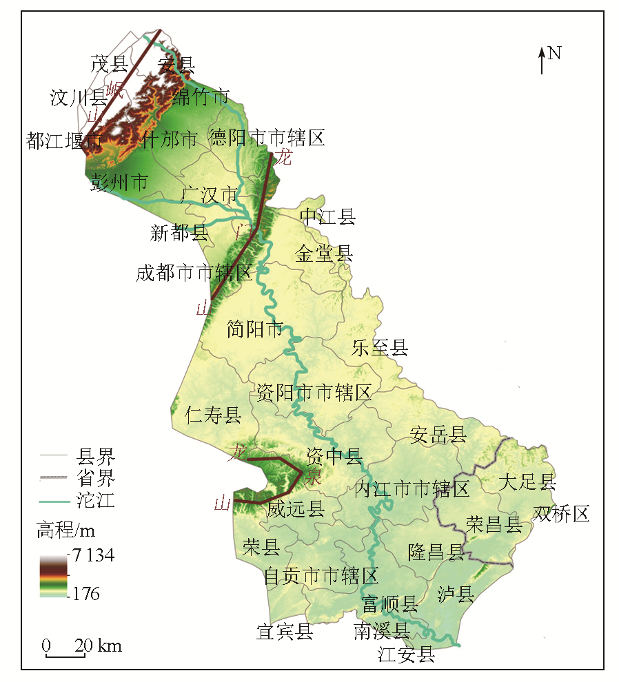
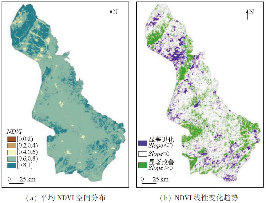
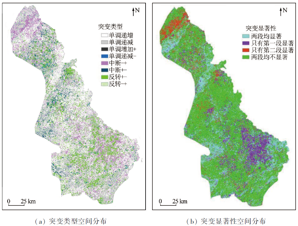
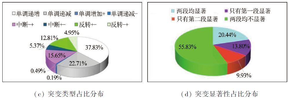
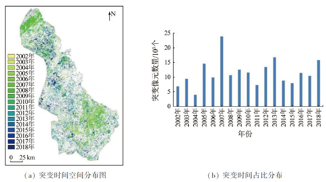
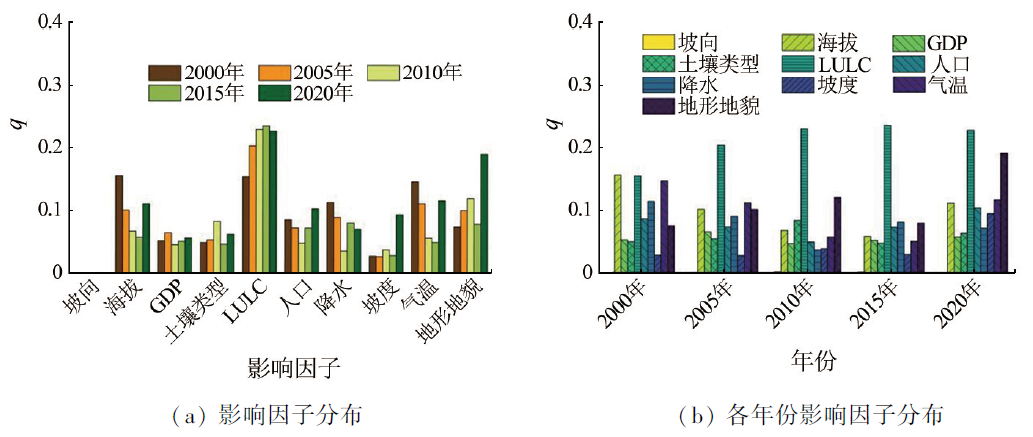
Abstract Vegetation, the main body of a terrestrial ecosystem, serves as an important indicator of environmental changes in a regional ecosystem. The Tuojiang River basin is an economically and industrially developed area in Sichuan. Dynamic vegetation monitoring and the analysis of factors driving its changes hold great significance for ecological change assessment and ecological protection. This study investigated the Tuojiang River basin. Based on MODIS data of normalized difference vegetation index (NDVI) from 2000 to 2021, this study detected, analyzed, and compared linear and nonlinear characteristics of the data, including mutation types and years, using linear regression Slope and an improved BFAST01 model. Additionally, this study explored the factors influencing the NDVI using the Optimal Parameters-based Geographic Detector (OPGD) model. The results indicate that more than 95% of the Tuojiang River basin exhibited NDVI values exceeding 0.6. The linear regression analysis for NDVI trends revealed that regions with significantly improved and significantly degraded vegetation coverage accounted for 18.07% and 10.60%, respectively, of the total area of the river basin, as indicated by image pixels. The BFAST01 nonlinear mutation analysis showed that the NDVI trends in the Tuojiang River basin over the 22 years can be categorized into eight mutation types, with the proportion of regions exhibiting improved vegetation coverage (58.62%) exceeding that of regions with degraded vegetation coverage (41.38%). These findings were consistent with the linear regression analysis, suggesting that the vegetation in the river basin was well protected in the 22 years. Mutations were concentrated between 2002 and 2018, with “interruption-+” and “reversal+-” representing the most common mutation types, accounting for 14.83% and 13.19%, respectively. In contrast, other mutation types exhibited a relatively even distribution across different stages. The results of the OPGD model revealed slight variations in the factors influencing NDVI across different years. Generally, the most influential factors included land use/land cover (LULC), elevation, and terrain and landforms, followed by meteorological factors such as temperature and precipitation. In contrast, other factors produced relatively minor impacts. Overall, despite some impacts, human factors like population and GDP exerted less influence on vegetation than natural factors in the Tuojiang River basin. Therefore, vegetation protection and restoration should consider the combined effects of both natural factors and anthropogenic activities.
|
| Keywords
NDVI
nonlinear trend
BFAST improved model
OPGD
Tuojiang River basin
|
|
|
|
Issue Date: 17 February 2025
|
|
|
| [1] |
李雪银, 张志强, 孙爱芝. 1982—2021年黄河流域植被覆盖时空演变及影响因素研究[J]. 地球环境学报, 2022, 13(4):428-436.
|
| [1] |
Li X Y, Zhang Z Q, Sun A Z. Study on the spatial-temporal evolution and influence factors of vegetation coverage in the Yellow River basin during 1982—2021[J]. Journal of Earth Environment, 2022, 13(4):428-436.
|
| [2] |
晋成名, 杨兴旺, 景海涛. 基于RS的陕北地区植被覆盖度变化及驱动力研究[J]. 自然资源遥感, 2021, 33(4):258-264.doi:10.6046 /zrzyyg.2021019.
|
| [2] |
Jin C M, Yang X W, Jing H T. A RS-based study on changes in fractional vegetation cover in North Shaanxi and their driving factors[J]. Remote Sensing for Natural Resources, 2021, 33(4):258-264.doi:10.6046 /zrzyyg.2021019.
|
| [3] |
王力, 赵思妍, 陈元鹏, 等. 基于GEE云平台的黄土高原生态修复区植被变化与归因[J]. 农业机械学报, 2023, 54(3):210-223.
|
| [3] |
Wang L, Zhao S Y, Chen Y P, et al. Vegetation change and attribution in ecological restoration area of Loess Plateau based on GEE cloud platform[J]. Transactions of the Chinese Society for Agricultural Machinery, 2023, 54(3):210-223.
|
| [4] |
Han Z, Song W. Interannual trends of vegetation and responses to climate change and human activities in the Great Mekong Subregion[J]. Global Ecology and Conservation, 2022,38:e02215.
|
| [5] |
陈文裕, 夏丽华, 徐国良, 等. 2000—2020年珠江流域NDVI动态变化及影响因素研究[J]. 生态环境学报, 2022, 31(7):1306-1316.
doi: 10.16258/j.cnki.1674-5906.2022.07.003
|
| [5] |
Chen W Y, Xia L H, Xu G L, et al. Dynamic variation of NDVI and its influencing factors in the Pearl River basin from 2000 to 2020[J]. Ecology and Environmental Sciences, 2022, 31(7):1306-1316.
|
| [6] |
Zhang X, Cao Q, Chen H, et al. Effect of vegetation carryover and climate variability on the seasonal growth of vegetation in the upper and middle reaches of the Yellow River basin[J]. Remote Sensing, 2022, 14(19):5011.
|
| [7] |
冯李. 金沙江流域植被覆盖度的遥感动态监测及其驱动机制研究[D]. 昆明: 云南师范大学, 2021.
|
| [7] |
Feng L. The study of remote sensing dynamic monitoring and its driving mechanism of vegetation cover in the Jinsha River basin[D]. Kunming: Yunnan Normal University, 2021.
|
| [8] |
孙金龙, 黄润秋. 切实履行生态环境保护职责不断开创新时代美丽中国建设新局面[N]. 人民日报,2022-11-21(11).
|
| [8] |
Sun J L, Huang R Q. Effectively perform the responsibility of ecological environment protection and constantly create a new situation of building a beautiful China in a new era[N]. People’s Daily,2022-11-21(11).
|
| [9] |
林妍敏, 李文慧, 南雄雄, 等. 基于地理探测器的宁夏贺兰山植被覆盖度时空分异及驱动因子[J]. 应用生态学报, 2022, 33(12):3321-3327.
doi: 10.13287/j.1001-9332.202212.025
|
| [9] |
Lin Y M, Li W H, Nan X X, et al. Spatial-temporal differentiation and driving factors of vegetation coverage in Ningxia Helan Mountain based on geodetector[J]. Chinese Journal of Applied Ecology, 2022, 33(12):3321-3327.
|
| [10] |
孙美荣, 孙鹏森. 西南高山亚高山区植被活动变化的气候驱动效应与可持续性[J]. 水土保持研究, 2023, 30(3):240-250.
|
| [10] |
Sun M R, Sun P S. Climate-driving effects and sustainability of vegetation activity change in alpine and subalpine areas of southwest China[J]. Research of Soil and Water Conservation, 2023, 30(3):240-250.
|
| [11] |
Gao X, Zhao D. Impacts of climate change on vegetation phenology over the Great Lakes region of Central Asia from 1982 to 2014[J]. Science of the Total Environment, 2022,845:157227.
|
| [12] |
张兴航, 张百平, 王晶, 等. 神农架林区植被分布与地形的关系研究[J]. 地球信息科学学报, 2020, 22(3):482-493.
doi: 10.12082/dqxxkx.2020.190553
|
| [12] |
Zhang X H, Zhang B P, Wang J, et al. Study on the relationship between terrain and distribution of the vegetation in Shennongjia forestry district[J]. Journal of Geo-Information Science, 2020, 22(3):482-493.
|
| [13] |
Mendes M P, Rodriguez-Galiano V, Aragones D. Evaluating the BFAST method to detect and characterise changing trends in water time series:A case study on the impact of droughts on the Mediterranean climate[J]. The Science of the Total Environment, 2022,846:157428.
|
| [14] |
辛宇, 孙梦鑫, 张岳, 等. 2000—2020年四川省植被覆盖时空变化特征及其气候驱动因子[J]. 水土保持通报, 2022, 42(4):312-319.
|
| [14] |
Xin Y, Sun M X, Zhang Y, et al. Spatiotemporal characteristics of vegetation cover and climate driving factors in Sichuan Province from 2000 to 2020[J]. Bulletin of Soil and Water Conservation, 2022, 42(4):312-319.
|
| [15] |
He C, Yan F, Wang Y, et al. Spatiotemporal variation in vegetation growth status and its response to climate in the Three-River Headwaters region,China[J]. Remote Sensing, 2022, 14(19):5041.
|
| [16] |
庞鑫, 刘珺. 气候变化对亚洲地区植被NDVI变化的影响[J]. 自然资源遥感, 2023, 35(2):295-305.doi:10.6064/zrzyyg.2022151.
|
| [16] |
Pang X, Liu J. Effects of climate changes on the NDVI of vegetation in Asia[J]. Remote Sensing for Natural Resources, 2023, 35(2):295-305.doi:10.6064/zrzyyg.2022151.
|
| [17] |
王叶兰, 杨鑫, 郝利娜. 2001—2021年川西高原植被NDVI时空变化及影响因素分析[J]. 自然资源遥感, 2023, 35(3):212-220.doi:10.6064/zrzyyg.2022240.
|
| [17] |
Wang Y L, Yang X, Hao L N. Spatio-temporal changes in the normalized difference vegetation index of vegetation in the western Sichuan Plateau during 2001—2021 and their driving factors[J]. Remote Sensing for Natural Resources, 2023, 35(3):212-220.doi:10.6064/zrzyyg.2022240.
|
| [18] |
Geng S, Zhang H, Xie F, et al. Vegetation dynamics under rapid urbanization in the Guangdong-Hong Kong-Macao Greater Bay area urban agglomeration during the past two decades[J]. Remote Sensing, 2022, 14(16):3993.
|
| [19] |
Zhong X, Li J, Wang J, et al. Linear and nonlinear characteristics of long-term NDVI using trend analysis:A case study of lancang-mekong river basin[J]. Remote Sensing, 2022, 14(24):6271.
|
| [20] |
罗爽, 刘会玉, 龚海波. 1982—2018年中国植被覆盖变化非线性趋势及其格局分析[J]. 生态学报, 2022, 42(20):8331-8342.
|
| [20] |
Luo S, Liu H Y, Gong H B. Nonlinear trends and spatial pattern analysis of vegetation cover change in China from 1982 to 2018[J]. Acta Ecologica Sinica, 2022, 42(20):8331-8342.
|
| [21] |
Schultz M, Clevers J G P W, Carter S, et al. Performance of vegetation indices from Landsat time series in deforestation monitoring[J]. International Journal of Applied Earth Observation and Geoinformation, 2016,52:318-327.
|
| [22] |
Li L, Zhang Y, Liu Q, et al. Regional differences in shifts of temperature trends across China between 1980 and 2017[J]. International Journal of Climatology, 2019, 39(3):1157-1165.
|
| [23] |
Brakhasi F, Hajeb M, Mielonen T, et al. Investigating aerosol vertical distribution using CALIPSO time series over the Middle East and North Africa (MENA),Europe,and India:A BFAST-based gradual and abrupt change detection[J]. Remote Sensing of Environment, 2021,264:112619.
|
| [24] |
Dupas R, Minaudo C, Gruau G, et al. Multidecadal trajectory of riverine nitrogen and phosphorus dynamics in rural catchments[J]. Water Resources Research, 2018, 54(8):5327-5340.
|
| [25] |
Horion S, Ivits E, De Keersmaecker W, et al. Mapping European ecosystem change types in response to land-use change,extreme climate events,and land degradation[J]. Land Degradation & Development, 2019, 30(8):951-963.
|
| [26] |
秦格霞, 吴静, 李纯斌, 等. 中国北方草地植被物候变化及其对气候变化的响应[J]. 应用生态学报, 2019, 30(12):4099-4107.
doi: 10.13287/j.1001-9332.201912.015
|
| [26] |
Qin G X, Wu J, Li C B, et al. Grassland vegetation phenology change and its response to climate changes in North China[J]. Chinese Journal of Applied Ecology, 2019, 30(12):4099-4107.
|
| [27] |
方贺, 张育慧, 何月, 等. 浙江省植被生态质量时空变化及其驱动因素分析[J]. 自然资源遥感, 2023, 35(2):245-254.doi:10.6064/zrzyyg.2022070.
|
| [27] |
Fang H, Zhang Y H, He Y, et al. Spatio-temporal variations of vegetation ecological quality in Zhejiang Province and their driving factors[J]. Remote Sensing for Natural Resources, 2023, 35(2):245-254.doi:10.6064/zrzyyg.2022070.
|
| [28] |
王劲峰, 徐成东. 地理探测器:原理与展望[J]. 地理学报, 2017, 72(1):116-134.
doi: 10.11821/dlxb201701010
|
| [28] |
Wang J F, Xu C D. Geodetector:Principle and prospective[J]. Acta Geographica Sinica, 2017, 72(1):116-134.
|
| [29] |
Song Y, Wang J, Ge Y, et al. An optimal parameters-based geographical detector model enhances geographic characteristics of explanatory variables for spatial heterogeneity analysis:Cases with different types of spatial data[J]. GIScience & Remote Sensing, 2020, 57(5):593-610.
|
| [30] |
王巨. 基于时序NDVI植被变化检测与驱动因素量化方法研究——以河西地区为例[D]. 兰州: 兰州大学, 2020.
|
| [30] |
Wang J. Methods for detecting vegetation changes and quantifying the driving factors using NDVI timeseries by taking Hexi as a case area[D]. Lanzhou: Lanzhou University, 2020.
|
| [31] |
Fang X, Zhu Q, Ren L, et al. Large-scale detection of vegetation dynamics and their potential drivers using MODIS images and BFAST:A case study in Quebec,Canada[J]. Remote Sensing of Environment, 2018,206:391-402.
|
| [32] |
Verbesselt J, Hyndman R, Newnham G, et al. Detecting trend and seasonal changes in satellite image time series[J]. Remote Sensing of Environment, 2010, 114(1):106-115.
|
| [33] |
Berveglieri A, Imai N N, Christovam L E, et al. Analysis of trends and changes in the successional trajectories of tropical forest using the Landsat NDVI time series[J]. Remote Sensing Applications:Society and Environment, 2021,24:100622.
|
| [34] |
Kovács G M, Horion S, Fensholt R. Characterizing ecosystem change in wetlands using dense earth observation time series[J]. Remote Sensing of Environment, 2022,281:113267.
|
| [35] |
R Core Team. 2018. R:A Language and Environment for Statistical Computing,Vienna[EB/OL].https://www.R-project.org.
url: https://www.R-project.org
|
| [36] |
Higginbottom T P, Symeonakis E. Identifying ecosystem function shifts in Africa using breakpoint analysis of long-term NDVI and RUE data[J]. Remote Sensing, 2020, 12(11):1894.
|
| [37] |
Smith V, Portillo-Quintero C, Sanchez-Azofeifa A, et al. Assessing the accuracy of detected breaks in Landsat time series as predictors of small scale deforestation in tropical dry forests of Mexico and Costa Rica[J]. Remote Sensing of Environment, 2019,221:707-721.
|
| [38] |
钟旭珍, 张素, 吴瑞娟, 等. 沱江流域土壤侵蚀动态变化及驱动力分析[J]. 水土保持研究, 2022, 29(2):43-49,56.
|
| [38] |
Zhong X Z, Zhang S, Wu R J, et al. Analysis of dynamic changes and driving forces of soil erosion in Tuojiang River basin[J]. Research of Soil and Water Conservation, 2022, 29(2):43-49,56.
|
| [39] |
朱思佳, 冯徽徽, 邹滨, 等. 2000—2019年洞庭湖流域植被 NPP时空特征及驱动因素分析[J]. 自然资源遥感, 2022, 34(3):196-206.doi:10.6064/zrzyyg.2021283.
|
| [39] |
Zhu S J, Feng H H, Zou B, et al. Spatial-temporal characteristics of 2000—2019 vegetation NPP of the Dongting Lake basin and their driving factors[J]. Remote Sensing for Natural Resources, 2022, 34(3):196-206.doi:10.6064/zrzyyg.2021283.
|
| [40] |
马炳鑫, 和彩霞, 靖娟利, 等. 1982—2019年中国西南地区植被变化归因研究[J]. 地理学报, 2023, 78(3):714-728.
doi: 10.11821/dlxb202303013
|
| [40] |
Ma B X, He C X, Jing J L, et al. Attribution of vegetation dynamics in Southwest China from 1982 to 2019[J]. Acta Geographica Sinica, 2023, 78(3):714-728.
doi: 10.11821/dlxb202303013
|
|
Viewed |
|
|
|
Full text
|
|
|
|
|
Abstract
|
|
|
|
|
Cited |
|
|
|
|
| |
Shared |
|
|
|
|
| |
Discussed |
|
|
|
|
 2025,
Vol. 37
2025,
Vol. 37