Exploring the object-oriented land cover classification based on Landsat and GF data
SHANG Ming1,2(), MA Jie2,3(), LI Yue1, ZHAO Fei4, GU Pengcheng5, PAN Guangyao6, LI Qian2,7, REN Yangyang1,8
1. School of Earth Science and Engineering, Hebei University of Engineering, Handan 056038, China 2. Xinjiang Key Laboratory of Water Cycle and Utilization in Arid Zone, Xinjiang Institute of Ecology and Geography, Chinese Academy of Sciences, Urumqi 830011, China 3. School of Architecture and Art, Hebei University of Engineering, Handan 056038, China 4. China Satellite Communications Co., Ltd., Beijing 100190, China 5. China Land Surveying and Planning Institute, Beijing 100871, China 6. Jinglang Ecological Environment Technology (Wuhan) Co., Ltd., Wuhan 420111, China 7. State Key Laboratory of Desert and Oasis Ecology, Xinjiang Institute of Ecology and Geography, Chinese Academy of Sciences, Urumqi 830011, China 8. Hebei Geographic Information Group Co., Ltd., Shijiazhuang 050000, China
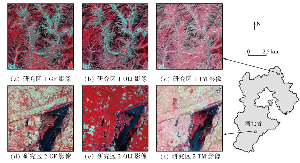
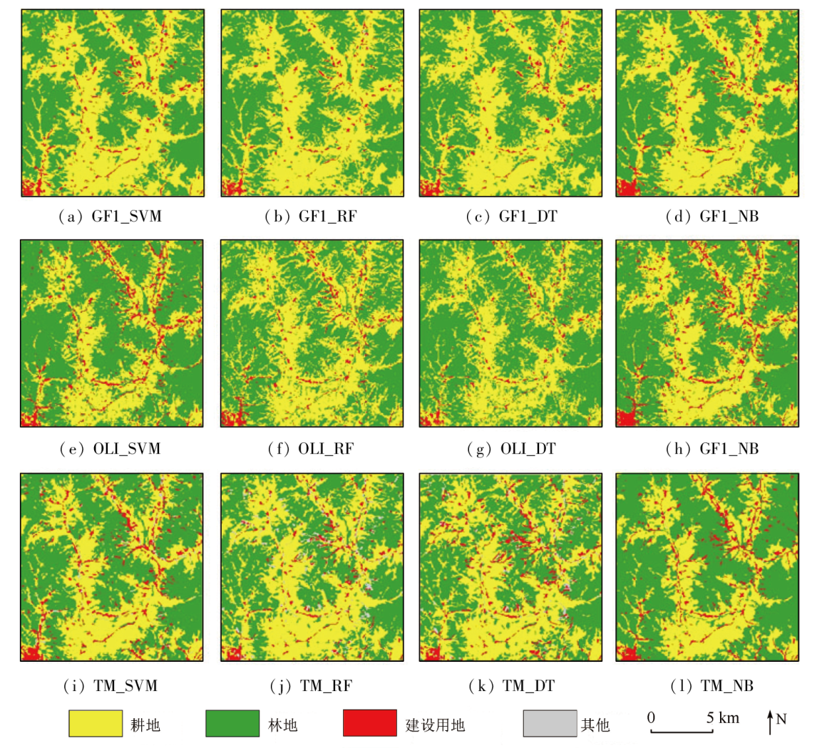
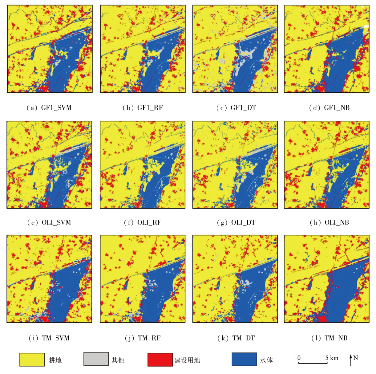
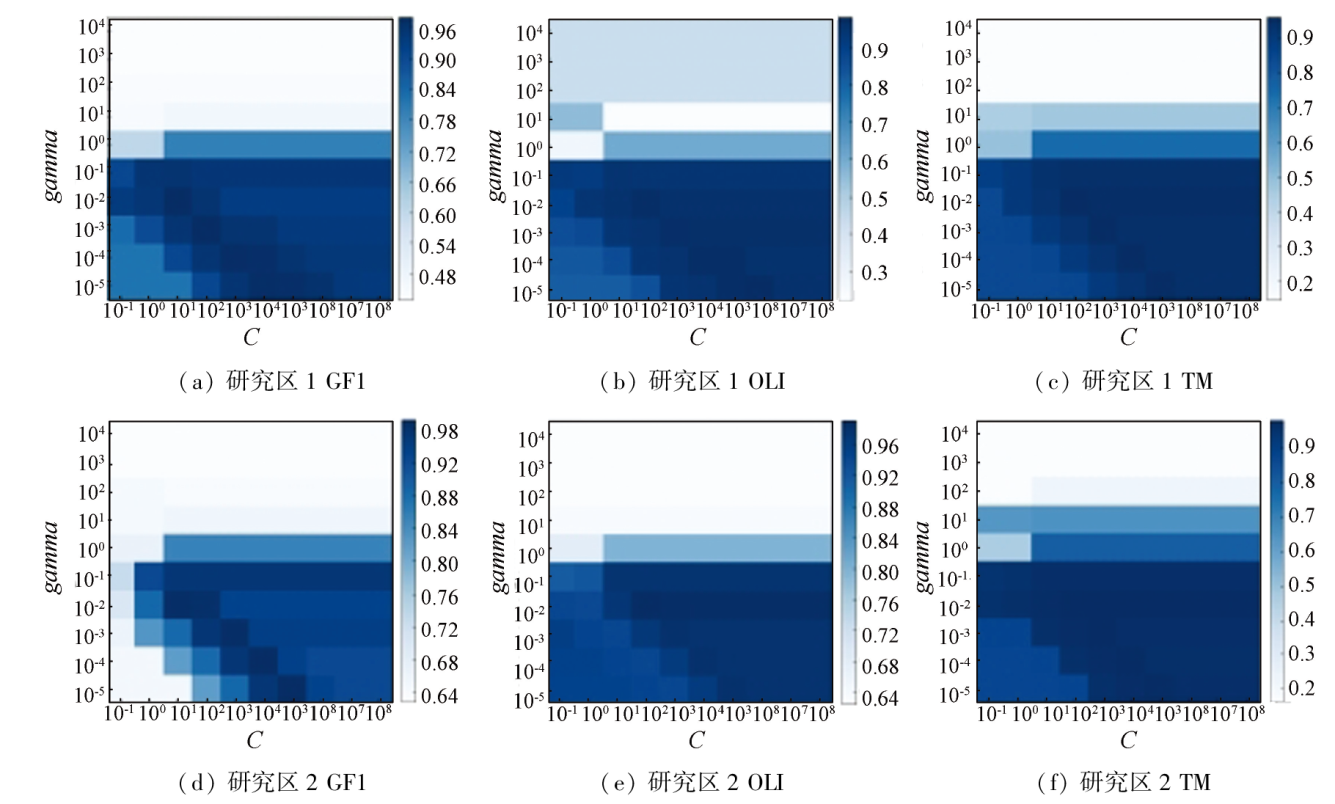
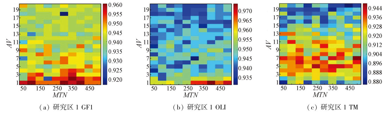
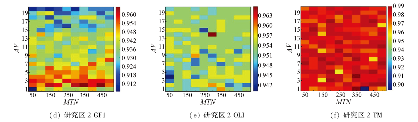
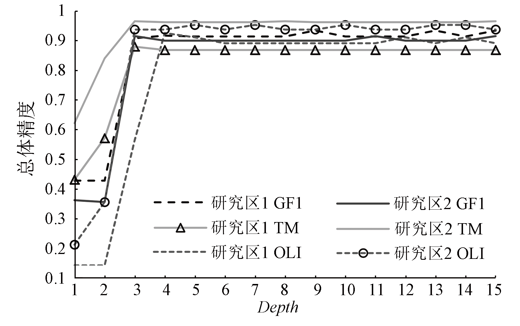
This study aims to explore the object-oriented classification based on moderate-resolution remote sensing data. Using the Landsat8 OLI, Landsat5 TM, and GF1 data obtained from the northern mountainous area and the southern plain area in Hebei Province, this study compared the land cover classification effects of four classifiers: support vector machine (SVM), random forest (RF), decision tree (DT), and naive Bayes (NB). Moreover, it analyzed the impacts of critical parameters in SVM, RF, and DT on the classification results. The findings indicate that the classification results of the classifiers vary slightly in the two study areas, with their effects decreased in the order of SVM, NB, RF, and DT. The classification accuracies of SVM and DT fluctuated significantly with parameter changes. With C values not below 103 and gamma values not exceeding 10-1, SVM can yield classification accuracies above 90% in all cases. With depth values over 3, DT exhibits relatively high and stable classification accuracies. With parameter changes, RF manifests slightly varying classification accuracies with nonsignificant variation patterns. The results of this study serve as a reference for exploring the object-oriented land cover classification based on moderate-resolution remote sensing data.
尚明, 马杰, 李悦, 赵菲, 顾鹏程, 潘光耀, 李倩, 任阳阳. Landsat和GF数据面向对象土地覆盖分类研究[J]. 自然资源遥感, 2024, 36(3): 240-247.
SHANG Ming, MA Jie, LI Yue, ZHAO Fei, GU Pengcheng, PAN Guangyao, LI Qian, REN Yangyang. Exploring the object-oriented land cover classification based on Landsat and GF data. Remote Sensing for Natural Resources, 2024, 36(3): 240-247.
Wu Y X, Wang J L, Han B M, et al. Forest classification for Motuo County:A method based on spatio - temporal - spectral characteristics[J]. Remote Sensing for Natural Resources, 2023, 35(1):180-188.doi:10.6046/zrzyyg.2022016.
Liang C X, Huang Q T, Wang S, et al. Identification of citrus orchard under vegetation indexes using multi-temporal remote sensing[J]. Transactions of the Chinese Society of Agricultural Engineering, 2021, 37(24):168-176.
Yao K, Zhang C J, He L, et al. Dynamic evaluation and prediction of ecological environment vulnerability in the middle-upper reaches of the Yalong River[J]. Remote Sensing for Land and Resources, 2020, 32(4):199-208.doi:10.6046/gtzyyg.2020.04.25.
Zhang Y, Ming D P, Zhao W Y, et al. The extraction and analysis of Luding earthquake-induced landslide based on high-resolution optical satellite images[J]. Remote Sensing for Natural Resources, 2023, 35(1):161-170.doi:10.6046/zrzyyg.2022434.
Du H G, Lin X C, Lu Y K, et al. Study on the rapid extraction model of post-earthquake shelter sites based on remote sensing images:A case study of the Yangbi MS6.4 Earthquake[J] Journal of Seismological Research, 2023, 46(1):116-127.
Li T C, Wang D R, Zhao L, et al. Classification and change analysis of the substrate of the Yongle Atoll in the Xisha Islands based on Landsat8 remote sensing data[J]. Remote Sensing for Natural Resources, 2023, 35(2):70-79.doi:10.6046/zrzyyg.2022207.
Wang F, Yang W N, Wang J, et al. Discussion on classification methods of urban features based on GF-2 images[J]. Bulletin of Surveying and Mapping, 2019(7):12-16.
doi: 10.13474/j.cnki.11-2246.2019.0210
Xiao W, Ren H, Lyu X J, et al. Vegetation classification by using UAV remote sensing in coal mining subsidence wetland with high ground-water level[J]. Transactions of the Chinese Society for Agricultural Machinery, 2019, 50(2):177-186.
[9]
Myint S W, Gober P, Brazel A, et al. Per-pixel vs.object-based classification of urban land cover extraction using high spatial resolution imagery[J]. Remote Sensing of Environment, 2011, 115(5):1145-1161.
Hu R M, Wei M, Yang C B, et al. Taking SPOT5 remote sensing data for example to compare pixel-based and object-oriented classification[J]. Remote Sensing Technology and Application, 2012, 27(3):366-371.
Wang C X, Zhang J, Li Y X, et al. The construction and verification of a water index in the complex environment based on GF-2 images[J]. Remote Sensing for Natural Resources, 2022, 34(3):50-58.doi:10.6046/zrzyyg.2021227.
Chen L P, Sun Y J. Comparison of object-oriented remote sensing image classification based on different decision trees in forest area[J]. Chinese Journal of Applied Ecology, 2018, 29(12):3995-4003.
Dong Z, Wang L, Zhu X C, et al. Water extraction in mountainous area based on spectral model and object-oriented method[J]. Remote Sensing Information, 2022, 37(4):121-127.
Nie Q, Qi K K, Zhao Y F. Object-oriented classification of high-resolution image combining super-pixel segmentation[J]. Bulletin of Surveying and Mapping, 2021(6):44-49.
doi: 10.13474/j.cnki.11-2246.2021.0174
Huang L, Wu C Y, Li X X, et al. Extraction of erigeron breviscapus planting information by unmanned aerial vehicle remote sensing based on weakly supervised semantic segmentation[J]. Transactions of the Chinese Society of Agricultural Machinery, 2022, 53(4):157-163,217.
[16]
尚明. 中分辨率遥感数据面向对象分类的影响要素研究[D]. 北京: 中国科学院大学, 2018.
Shang M. Research on influence factors of object-based classification of medium resolution remote sensing data[D]. Beijing: University of Chinese Academy of Sciences, 2018.
[17]
Shang M, Wang S X, Zhou Y, et al. Effects of training samples and classifiers on classification of Landsat8 imagery[J]. Journal of the Indian Society of Remote Sensing, 2018, 46(9):1333-1340.
[18]
Ma L, Li M C, Ma X X, et al. A Review of supervised object based land-cover image classification[J]. ISPRS Journal of Photogrammetry and Remote Sensing, 2017, 130:277-293.
[19]
Qian Y G, Zhou W Q, Yan J L, et al. Comparing machine learning classifiers for object-based land cover classification using very high resolution imagery[J]. Remote Sensing, 2014, 7(1):153-168.
[20]
Shang M, Wang S X, Zhou Y, et al. Object-based image analysis of suburban landscapes using Landsat8 imagery[J]. International Journal of Digital Earth, 2019, 12(6):720-736.
[21]
Faris H, Hassonah M A, Al-Zoubi A M, et al. A multi-verse optimizer approach for feature selection and optimizing SVM parameters based on a robust system architecture[J]. Neural Computing and Applications, 2018, 30(8):2355-2369.
Du K L, Guan Y L, Pei D D, et al. Remote sensing classification of Poyang Lake wetland based on PSO parameter optimized support vector machine[J]. Jiangxi Science, 2018, 36(1):66-72,129.
[23]
Ma L, Cheng L, Li M C, et al. Training set size,scale,and features in geographic object-based image analysis of very high resolution unmanned aerial vehicle imagery[J]. ISPRS Journal of Photogrammetry and Remote Sensing, 2015, 102:14-27.
Shi C X, Zhao C G, Pang L. Research on random forest remote sensing image classification based on superpixel statistics[J]. Application Research of Computers, 2018, 35(12):3798-3802.
Li H K, Wang L J, Xiao S S. Random forest classification of land use in hilly and mountaineous areas of southern China using multi-source remote sensing data[J]. Transactions of the Chinese Society of Agricultural Engineering, 2021, 37(7):244-251.
 2024, Vol. 36
  ), 马杰2,3(