|
|
|
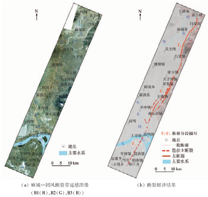
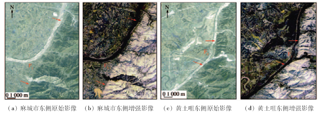
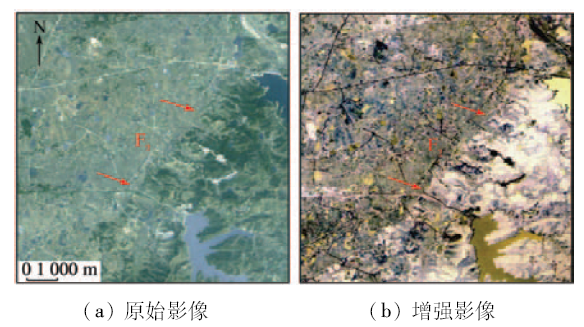
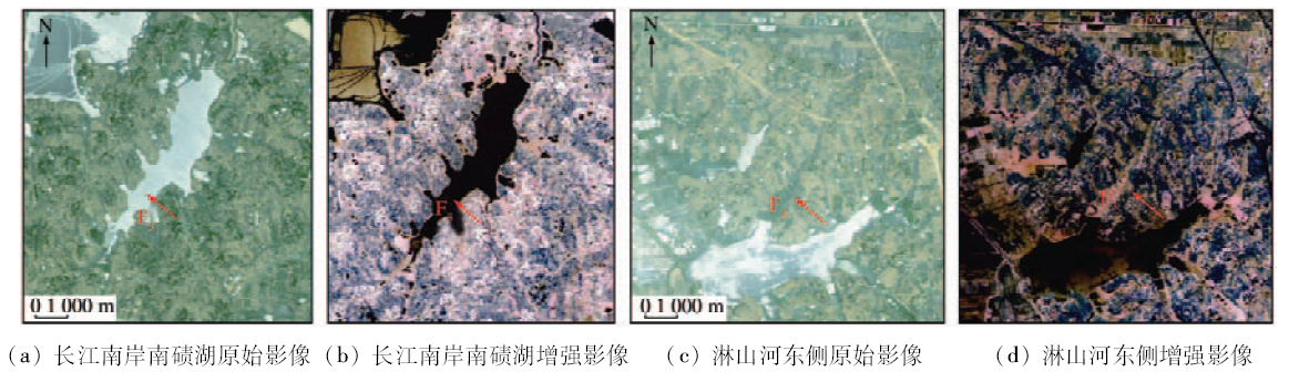
Abstract Remote sensing image can reflect distribution rules and structural features of active faults exhibition space from the macro. Based on regional geological study, the authors used data preprocessing, information enhancement and data fusion to improve the degree of clarity and interpretation of remote sensing images. The interpretation keys of the fault zone were established based on the spectral characteristics and geometric flag of the remote sensing images, and the interpretation of the faults and their activities was carried out. Combined with field investigation, the macro analysis and segmentation activity study of Macheng ―Tuanfeng fault were carried out. The results show that Macheng - Tuanfeng fault zone can be divided into northern, middle and southern sections according to the intensity of the control force. The linear characteristics of the northern section are apparent in the image, and the interpretation key of the fault is remarkable. The fracture control force of the middle section is weak, whereas the linear characteristics of the image are fuzzy. The southern section is a buried fault. Remote sensing technology plays a very important role in the survey of the activity of Macheng―Tuanfeng fault zone; the application of high resolution remote sensing imagery and remote sensing image processing technology, in particular, can not only speed up the progress of the investigation but also provide guiding information for the field survey, so as to improve the survey efficiency and accuracy.
|
| Keywords
linear structure
remote sensing
Macheng-Tuanfeng fault zone
interpretation
|
|
|
|
Issue Date: 08 February 2018
|
|
|
| [1] |
张景发,陶夏新,田云锋,等.城市周边活断层探测中遥感技术的应用[J].自然灾害学报,2004,13(1):137-145.
|
| [1] |
Zhang J F,Tao X X,Tian Y F,et al.Application of remote sensing technique to exploration of active fault around urb[J].Journal of Natural Disasters,2004,13(1):137-145.
|
| [2] |
甘家思,刘锁旺.鄂豫皖毗邻区的某些地震地质特征[J]. 地壳形变与地震, 1981(4):56-64.
|
| [2] |
Gan J S,Liu S W.Some seismic and geologic characteristics Eyuwan contiguous zone[J]. Crustal Deformation and Earthquake, 1981(4):56-64.
|
| [3] |
古成志. 1932年湖北麻城黄土岗6级地震与麻城—团凤断裂带的新活动[J].地壳形变与地震,1981(2):83-90.
|
| [3] |
Gu C Z.The new activities of Huangtugang six earthquake and Macheng―Tuanfeng fault zone in 1932[J].Crustal Deformation and Earthquake,1981(2):83-90.
|
| [4] |
谢广林. 中国活动断裂遥感信息分析[M].北京:地震出版社,2000:22-32.
|
| [4] |
Xie G L.Chinese Activities Fracture Analysis of Remote Sensing[M].Beijing:Earthquake Press,2000:22-32.
|
| [5] |
雷东宁,蔡永建,郑水明,等.麻城―团风断裂带中段新活动特征及构造变形机制研究[J].大地测量与地球动力学,2012,32(1):21-25.
|
| [5] |
Lei D N,Cai Y J,Zheng S M,et al.Study of quaternary activity and tectonic deformation mechanism of Macheng―Tuanfeng fault belt[J].Journal of Geodesy and Geodynamics,2012,32(1):21-25.
|
| [6] |
甘家思. 湖北麻城1932年6级地震的孕震构造模式[J].西北地震学报,1981,3(4):43-48.
|
| [6] |
Gan J S.The tectonic pattern of earthquake(M=6.0) of 1932 at the Huangtugang, Macheng,Hubei Province[J].Northwestern Seismological Journal,1981,3(4):43-48.
|
| [7] |
林伟,王清晨,Faure M,等.大别山的构造变形期次和超高压岩石折返的动力学[J].地质学报,2003,77(1):44-55.
|
| [7] |
Lin W,Wang Q C,Faure M,et al.Different deformation stages of the Dabieshan mountains and UHP rocks exhumation mechanism[J].Acta Geologica Sinica,2003,77(1):44-55.
|
| [8] |
郭啟倩,李盛乐,刘珠妹.断层高分辨率遥感在线解译及产状测量平台[J].国土资源遥感,2016,28(1):190-196.doi:10.6046/gtzyyg.2016.01.28.
|
| [8] |
Guo Q Q,Li S L,Liu Z M.Platform of online interpretation and attitude measurement for faults using high resolution remote sensing image[J].Remote Sensing for Land and Resources,2016,28(1):190-196.doi:10.6046/gtzyyg.2016.01.28.
|
| [9] |
宿渊源,张景发,何仲太,等.资源卫星三号DEM数据在活动构造定量研究中的应用评价[J].国土资源遥感,2015,27(4):122-130.doi:10.6046/gtzyyg.2015.04.19.
|
| [9] |
Su Y Y,Zhang J F,He Z T,et al.Assessment of applying ZY-3 DEM data to quantitative study of active structures[J].Remote Sensing for Land and Resources,2015,27(4):122-130.doi:10.6046/gtzyyg.2015.04.19.
|
| [10] |
刘新星,陈建平,曾敏,等.基于多源遥感数据的西藏羌多地区地质构造解译[J].国土资源遥感,2015,27(3):154-160.doi:10.6046/gtzyyg.2015.03.24.
|
| [10] |
Liu X X,Chen J P,Zeng M,et al.Geological structural interpretation of Qiangduo area in Tibet based on multi-source remote sensing data[J].Remote Sensing for Land and Resources,2015,27(3):154-160.doi:10.6046/gtzyyg.2015.03.24.
|
| [11] |
郑文俊,郭华,袁道阳,等.遥感影像信息在活动断裂研究中的应用[J].高原地震,2002,14(2):15-21.
|
| [11] |
Zheng W J,Guo H,Yuan D Y,et al.Application of remote sensing image information in the research of active faults[J].Earthquake Research in Plateau,2002,14(2):15-21.
|
| [12] |
隋志龙,李德威,黄春霞.断裂构造的遥感研究方法综述[J].地理学与国土研究,2002,18(3):34-37,44.
|
| [12] |
Sui Z L,Li D W,Huang C X.Overview of research approach of faults based on remote sensing technology[J].Geography and Territorial Research,2002,18(3):34-37,44.
|
| [13] |
韩玲,王润平.武都—文县地区遥感影像线性构造解译[J].地球科学与环境学报,2008,30(4):434-437.
|
| [13] |
Han L,Wang R P.Remote sensing image interpretation of linear tectonics in Wudu-Wenxian area[J].Journal of Earth Sciences and Environment,2008,30(4):434-437.
|
| [14] |
张微,陈汉林,姚琪,等.遥感技术在孝丰―三门湾活动断裂调查中的应用——以杭州地区为例[J].浙江大学学报(理学版),2008,35(1):111-116.
|
| [14] |
Zhang W,Chen H L,Yao Q,et al.Application of remote sensing technique to the surveying of Xiaofeng―Sanmenwan active faults:Based on Hangzhou area[J].Journal of Zhejiang University(Science Edition),2008,35(1):111-116.
|
| [15] |
郭卫英,柔洁,王翠.感技术在乌鲁木齐市活断层探测中的应用[J].内陆地震,2006,20(1):57-64.
|
| [15] |
Guo W Y,Rou J,Wang C.Application of remote sensing technique to active fault exploration in Urumqi City[J].Inland Earthquake,2006,20(1):57-64.
|
| [16] |
范敏,黄洁,韩磊,等.西南三江地区活动断裂遥感研究[J].国土资源遥感,2010,22(s1):194-199.doi:10.6046/gtzyyg.2010.s1.40.
|
| [16] |
Fan M,Huang J,Han L,et al.Remote sensing geological studies of active faults in the Three-River area of Southwest China[J].Remote Sensing for Land and Resources,2010,22(s1):194-199.doi:10.6046/gtzyyg.2010.s1.40.
|
| [17] |
张明华. 西藏墨脱公路断裂构造遥感分析及信息提取[J].国土资源遥感,2006,18(1):56-60.doi:10.6046/gtzyyg.2006.01.13.
|
| [17] |
Zhang M H.The remote sensing interpretation and extraction of fault structure information for Motuo highway construction in Tibet[J].Remote Sensing for Land and Resources,2006,18(1):56-60.doi:10.6046/gtzyyg.2006.01.13.
|
| [18] |
张微,陈汉林,李启敏,等.基于遥感技术研究萧山—球川断裂带[J].科技通报,2008,24(2):156-161.
|
| [18] |
Zhang W,Chen H L,Li Q M,et al.The study on Xiaoshao―Qiuchuan faults zone based on remote sensing technique[J].Bulletin of Science and Technology,2008,24(2):156-161.
|
| [19] |
杨树文,冯光胜,高山.宁武高速公路断裂构造遥感解译与评价研究[J].国土资源遥感,2010,22(2):73-76.doi:10.6046/gtzyyg.2010.02.16.
|
| [19] |
Yang S W,Feng G S,Gao S.The evaluation and remote sensing interpretation of faults along the Ningwu superhighway[J].Remote Sensing for Land and Resources,2010,22(2):73-76.doi:10.6046/gtzyyg.2010.02.16.
|
| [20] |
董广昊,杨清福,杨以道.长春市隐伏断裂遥感解译[J].东北地震研究,2009,25(3):66-75.
|
| [20] |
Dong G H,Yang Q F,Yang Y D.Remote sensing interpretation of buried faults in Changchun City[J].Seismological Research of Northeast China,2009,25(3):66-75.
|
| [21] |
邓辉. 高精度卫星遥感技术在地质灾害调查与评价中的应用[D].成都:成都理工大学,2007:25-35.
|
| [21] |
Deng H.Application on Investigation and Evaluation of Geohazard by High-precision Satellite Remote Sensing Technique[D].Chengdu:Chengdu University of Technology,2007:25-35.
|
| [22] |
齐信,邵长生,陈州丰,等.多源遥感数据在断裂构造解译中的应用[J].大地测量与地球动力学,2012,32(4):90-93.
|
| [22] |
Qi X,Shao C S,Chen Z F,et al.Application of multi-source remote sensing data in fault structure interpretation[J].Journal of Geodesy and Geodynamics,2012,32(4):90-93.
|
|
Viewed |
|
|
|
Full text
|
|
|
|
|
Abstract
|
|
|
|
|
Cited |
|
|
|
|
| |
Shared |
|
|
|
|
| |
Discussed |
|
|
|
|
 2018,
Vol. 30
2018,
Vol. 30
 ), Guangning LIU, Changsheng HUANG