|
|
|
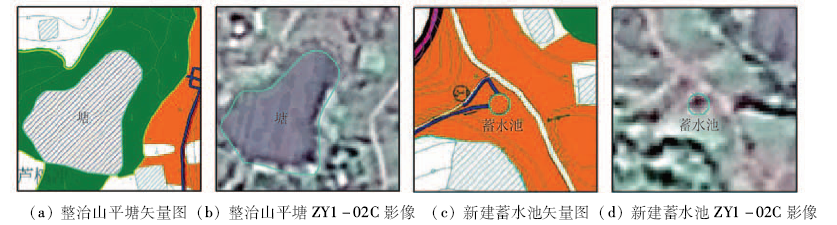
Abstract The purpose of this paper is to study the potential application of ZY1-02C satellite data when they are used in the checkup of land consolidation project. The land consolidation project in Neijiang of Sichuan Province was selected as a case study for this research. Based on the software including ERDAS, AutoCAD and ArcGIS, the authors carried out the indoor verification and the field investigation to put forward the complete technical method and operation procedures by using 02C satellite data for the check up of land consolidation project. The results show that the 02C satellite images could be used to evaluate the cultivation in land leveling project, the shanping pool in irrigation and drainage engineering, and the field road in road project. Nevertheless, the projects, such as the bank of paddy field, field drain, water tank and the passing track, can hardly be checked. The quality of project cannot be evaluated. The conclusion of the paper is that the 02C satellite image can be used in land consolidation project checkup.
|
| Keywords
ZY1-02C satellite
remote sensing
land consolidation
checkup
information extraction
|
|
|
|
Issue Date: 08 February 2018
|
|
|
| [1] |
胡静,金晓斌,陈原,等.土地整治重大工程项目建设监测管理系统的设计与实现[J].中国土地科学,2012,26(7):44-49.
|
| [1] |
Hu J,Jin X B,Chen Y,et al.Design and implementation of monitoring and management system for the key land consolidation and readjustment projects[J].China Land Science,2012,26(7):44-49.
|
| [2] |
胡振琪,赵艳玲,姜晶,等.土地整理复垦项目验收方案研究[J].农业工程学报,2005,21(6):59-63.
|
| [2] |
Hu Z Q,Zhao Y L,Jiang J,et al.Scheme and criteria for checkup and acceptance of land consolidation and reclamation projects[J].Transactions of the CSAE,2005,21(6):59-63.
|
| [3] |
张述清,杨焰,袁千淇,等.土地整治工程量复核的实践[J].中国土地科学,2012,26(3):63-67.
|
| [3] |
Zhang S Q,Yang Y,Yuan Q Q,et al.Practice of quantity checkage of land consolidation and readjustment projects[J].China Land Science,2012,26(3):63-67.
|
| [4] |
夏权,夏萍,冯东,等.安徽省含山县土地整理耕地质量评价及其变化研究[J].国土资源遥感,2015,27(1):182-186.doi:10.6046/gtzyyg.2015.01.29.
|
| [4] |
Xia Q,Xia P,Feng D,et al.Evaluation and change research on the quality of cultivated land in land consolidation of Hanshan County,Anhui Province[J].Remote Sensing for Land and Resources,2015,27(1):182-186.doi:10.6046/gtzyyg.2015.01.29.
|
| [5] |
彭玉玲,林爱文,王珂,等.资源枯竭型城市的工矿废弃地复垦利用综合效益评价——以黄石市七约山矿区为例[J].国土资源遥感,2015,27(3):161-166.doi:10.6046/gtzyyg.2015.03.25.
|
| [5] |
Peng Y L,Lin A W,Wang K,et al.Comprehensive benefits evaluation of mining wasteland reclamation and utilization in resource-exhausted cities:A case study of the Qiyueshan mining area,Huangshi City[J].Remote Sensing for Land and Resources,2015,27(3):161-166.doi:10.6046/gtzyyg.2015.03.25.
|
| [6] |
孟宪素,李少帅.遥感技术在土地整理复垦开发项目监管工作中的应用实践[J].资源与产业,2009,11(2):66-70.
|
| [6] |
Meng X S,Li S S.Application of RS in supervision over land consolidation and rehabilitation[J].Resources and Industries,2009,11(2):66-70.
|
| [7] |
张兵,崔希民,赵彦博,等.基于High-1卫星影像的土地整治遥感监测方法研究与实践[J].农业工程学报,2015,31(20):225-233.
|
| [7] |
Zhang B,Cui X M,Zhao Y B,et al.Method and application of remote sensing monitoring in land consolidation based on High-1 satellite image[J].Transactions of the Chinese Society of Agricultural Engineering,2015,31(20):225-233.
|
| [8] |
李少帅,陈原,张超,等.基于多时相高分辨率遥感影像的土地整治项目进展评价模型研究[J].中国土地科学,2014,28(3):83-88.
|
| [8] |
Li S S,Chen Y,Zhang C,et al.Study on evaluation progress model in the implementation of land consolidation projects based on multi-temporal high-resolution remote sensing data[J].China Land Science,2014,28(3):83-88.
|
| [9] |
杨清华,李景华,韩旭,等.QuickBird遥感数据在土地整理工作中的应用[J].国土资源遥感,2007,19(4):72-75.doi:10.6046/gtzyyg.2007.04.16.
|
| [9] |
Yang Q H,Li J H,Han X,et al.The application of QuickBird remote sensing data to land re-organization[J].Remote Sensing for Land and Resources,2007,19(4):72-75.doi:10.6046/gtzyyg.2007.04.16.
|
| [10] |
郭云开,陈正阳,彭悦,等.土地复垦工程的遥感评价[J].遥感技术与应用,2008,23(3):249-254.
|
| [10] |
Guo Y K,Chen Z Y,Peng Y,et al.Evaluation of land reclamation based on RS[J].Remote Sensing Technology and Application,2008,23(3):249-254.
|
| [11] |
安志宏,聂洪峰,王昊,等.ZY-1 ZY1-02C数据在矿山遥感监测中的应用研究与分析[J].国土资源遥感,2015,27(2):174-182.doi:10.6046/gtzyyg.2015.02.27.
|
| [11] |
An Z H,Nie H F,Wang H,et al.Study and analysis of application of ZY-1 02C satellite data to remote sensing monitoring technology for exploration of mineral resources[J].Remote Sensing for Land and Resources,2015,27(2):174-182.doi:10.6046/gtzyyg.2015.02.27.
|
| [12] |
何宇华,柳陈胜,史良树,等.基于资源一号02C卫星数据的土地执法监察应用研究——以浙江长兴县为例[J].测绘与空间地理信息,2013,36(9):84-86.
|
| [12] |
He Y H,Liu C S,Shi L S,et al.Law enforcement to monitor applications based on ZY1-02 C satellite data:A case study of Changxing,Zhejiang[J].Geomatics & Spatial Information Technology,2013,36(9):84-86.
|
| [13] |
李慎鹏,雷帆,彭笃明.资源一号02C卫星在土地利用动态监测中的应用[J].测绘科学,2014,39(9):91-93,129.
|
| [13] |
Li S P,Lei F,Peng D M.Application of ZY1-02C satellite in land-use dynamic monitoring[J].Science of Surveying and Mapping,2014,39(9):91-93,129.
|
| [14] |
马利刚,张乐平,邓劲松,等.资源一号“02C”遥感影像土地利用分类[J].浙江大学学报(工学版),2013,47(8):1508-1516.
|
| [14] |
Ma L G,Zhang L P,Deng J S,et al.Land use classification using ZY1-“02C” remote sensing images[J].Journal of Zhejiang University(Enginerring Science),2013,47(8):1508-1516.
|
| [15] |
张微,陈玲,佟晶,等.资源一号ZY-1 02C卫星图像在区域地质调查中的应用前景[J].遥感信息,2015,30(3):93-98.
|
| [15] |
Zhang W,Chen L,Tong J,et al.Prospect analysis of regional geological survey with use of ZY-1 02C satellite imagery[J].Remote Sensing Information,2015,30(3):93-98.
|
| [16] |
林楠,姜琦刚,杨佳佳,等.基于资源一号02C高分辨率数据的农业区土地利用分类[J].农业机械学报,2015,46(1):278-284.
|
| [16] |
Lin N,Jiang Q G,Yang J J,et al.Classifications of agricultural land use based on high-spatial resolution ZY1-02C remote sensing images[J].Transactions of the Chinese Society for Agricultural Machinery,2015,46(1):278-284.
|
| [17] |
李延成,李军,刘慧霞,等.基于最小二乘法的区域整体最优匹配选取控制点的方法[J].测绘科学,2012,37(6):94-97.
|
| [17] |
Li Y C,Li J,Liu H X,et al.Method of selecting control point based on least squares of regional integral optimal matching[J].Science of Surveying and Mapping,2012,37(6):94-97.
|
| [18] |
高媛赟,温小荣,林国忠,等.中国资源一号02C卫星数据的融合评价及应用[J]. 林业资源管理, 2015(1):101-105.
|
| [18] |
Gao Y Y,Wen X R,Lin G Z,et al.Evaluation and application of fusion methods with ZY1-02C data[J]. Forest Resources Management, 2015(1):101-105.
|
|
Viewed |
|
|
|
Full text
|
|
|
|
|
Abstract
|
|
|
|
|
Cited |
|
|
|
|
| |
Shared |
|
|
|
|
| |
Discussed |
|
|
|
|
 2018,
Vol. 30
2018,
Vol. 30
 ), Yinling ZHANG1(