|
|
|
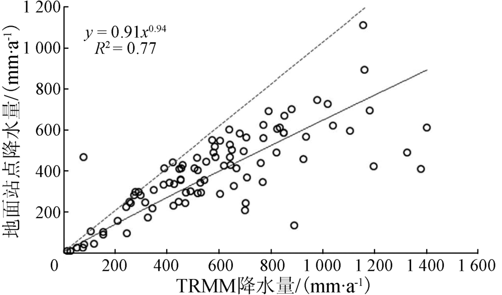
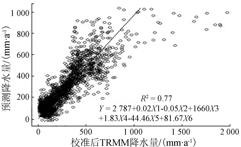
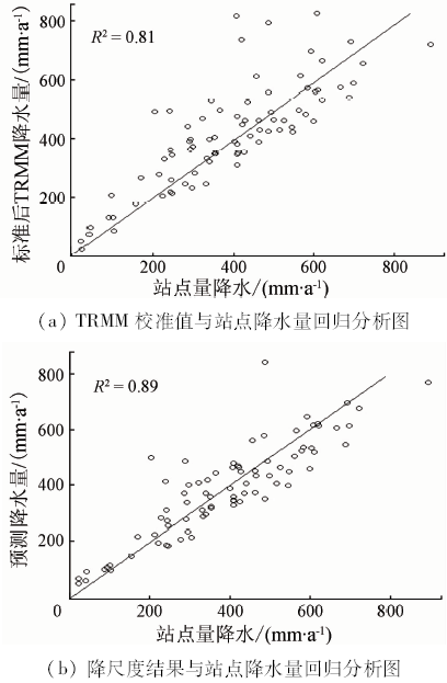
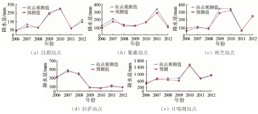
Abstract So far, precipitation products with high spatial resolution have been crucial for the basin scale hydrology, meteorology and ecology. The climate in the Tibetan Plateau is of vital significance to global climate variation. So, the study of the distribution of precipitation with high spatial resolution is in the basic position of environmental science. Based on random-forest algorithm, the authors introduced environmental factors such as topography and vegetation, which was developed for downscaling the remote sensing precipitation products accurately and effectively. The non-linear spatial statistical downscaling model was demonstrated with the Tropical Rainfall Measuring Mission (TRMM) 3B43 dataset with the spatial resolution of 0.25°, the Normalized Difference Vegetation Index (NDVI) from NOAA-AVHRR with the spatial resolution of 8km, the Digital Elevation Model (DEM) from Shuttle Radar Topography Mission (SRTM) with the spatial resolution of 90 m and the information of slope, aspect, longitude and latitude. And the model based on time series and vegetation factor, which was demonstrated with TRMM3B43 annual data in order to forecast the precipitation, was introduced in this paper. The downscaling results were validated by applying the observations from the rain gauges in the Tibetan Plateau and the coefficient of determination R 2 is 0.89. The analytical results showed that the downscaling results improved the spatial resolution and accuracy by applying the random-forest algorithm and introducing environmental factors. And the model, which was developed for forecasting the precipitation, captured the trends in inter-annual variability and the magnitude of annual precipitation with the R 2 ranging from 0.81 to 0.87.
|
| Keywords
Tibetan Plateau
precipitation
downscale
forecast
Random-forest
time series
|
|
|
|
Corresponding Authors:
Yuanyuan WEI
E-mail: weiyy@radi.ac.cn
|
|
Issue Date: 10 September 2018
|
|
|
| [1] |
吴国雄 . 我国青藏高原气候动力学研究的近期进展[J]. 第四季研究, 2004,24(1):1-9.
|
| [1] |
Wu G X . Recent progress in the study of the Qinghai-Xizang plateau climate dynamics in China[J]. Quaternary Sciences, 2004,24(1):1-9.
|
| [2] |
Immerzeel W W , Van Beek L P H,Bierkens M F P.Climate change will affect the Asian water towers[J]. Science, 2010,32(8):1382-1385.
|
| [3] |
程珂, 朱祯, 李铭 , 等. TRMM3B43降水产品在西藏地区的精度检验和应用[J]. 水利水电技术, 2014,45(1):44-46.
|
| [3] |
Cheng K, Zhu Z, Li M , et al. Application and accuracy testing of TRMM3B43 rainfall product in Tibetan Region[J]. Water Resources and Hydropower Engineering, 2014,45(1):44-46.
|
| [4] |
刘永和, 郭维栋, 冯锦明 , 等. 气象资料的统计降尺度方法综述[J]. 地球科学进展, 2011,26(8):837-847.
|
| [4] |
Liu Y H, Guo W D, Feng J M , et al. A summary of methods for statistical downscaling of meteorological data[J]. Advances in Earth Science, 2011,26(8):837-847.
|
| [5] |
Zorita E, Hughes J P, Lettemaier D P . Stochastic characterization of regional circulation patterns for climate model diagnosis and estimation of local precipitation[J]. Journal of Climate, 1995,8(5):1023-1042.
doi: 10.1175/1520-0442(1995)008<1023:SCORCP>2.0.CO;2
url: http://journals.ametsoc.org/doi/abs/10.1175/1520-0442%281995%29008%3C1023%3ASCORCP%3E2.0.CO%3B2
|
| [6] |
Charles S P, Bates B C, Hughes J P . A spatiotemporal model for downscaling precipitation occurrence and amounts[J]. Journal of Geophysical Research: Atmospheres, 1999,104(D24):31657-31669.
doi: 10.1029/1999JD900119
url: http://doi.wiley.com/10.1029/1999JD900119
|
| [7] |
Immerzeel W W, Rutten M M, Droogers P . Spatial downscaling of TRMM precipitation using vegetative response on the Iberian Peninsula[J]. Remote Sensing of Environment, 2009,113(2):362-370.
doi: 10.1016/j.rse.2008.10.004
url: http://linkinghub.elsevier.com/retrieve/pii/S0034425708003155
|
| [8] |
Jia S F, Zhu W B, Lyu A F , et al. A statistical spatial downscaling algorithm of TRMM precipitation based on NDVI and DEM in the Qaidam Basin of China[J]. Remote Sensing of Environment, 2011,115(12):3069-3079.
doi: 10.1016/j.rse.2011.06.009
url: http://linkinghub.elsevier.com/retrieve/pii/S0034425711002331
|
| [9] |
Grist J, Nicholson S E, Mpolokang A . On the use of NDVI for estimating rainfall fields in the Kalahari of Botswana[J]. Journal of Arid Environments, 1997,35(2):195-214.
doi: 10.1006/jare.1996.0172
url: http://linkinghub.elsevier.com/retrieve/pii/S014019639690172X
|
| [10] |
Onema J M K, Taigbenu A . NDVI-rainfall relationship in the Semliki watershed of the equatorial Nile[J]. Physics and Chemistry of the Earth,Parts A/B/C, 2009,34(13/16):711-721.
doi: 10.1016/j.pce.2009.06.004
url: http://linkinghub.elsevier.com/retrieve/pii/S1474706509000527
|
| [11] |
Iwasaki H . NDVI prediction over Mongolian grassland using GSMaP precipitation data and JRA-25/JCDAS temperature data[J]. Journal of Arid Environments, 2009,73(4/5):557-562.
doi: 10.1016/j.jaridenv.2008.12.007
url: http://linkinghub.elsevier.com/retrieve/pii/S0140196308003674
|
| [12] |
Kummerow C, Barnes W, Kozu T , et al. The Tropical Rainfall Measuring Mission (TRMM) sensor package[J]. Journal of Atmospheric and Oceanic Technology, 1998,15(3):809-817.
doi: 10.1175/1520-0426(1998)015<0809:TTRMMT>2.0.CO;2
url: http://journals.ametsoc.org/doi/abs/10.1175/1520-0426%281998%29015%3C0809%3ATTRMMT%3E2.0.CO%3B2
|
| [13] |
Huffman G J, Bolvin D T, Nelkin E J , et al. The TRMM multisatellite precipitation analysis (TMPA):Quasi-global,multiyear,combined-sensor precipitation estimates at fine scales[J]. Journal of Hydrometeorology, 2007,8(1):38-55.
doi: 10.1175/JHM560.1
url: http://journals.ametsoc.org/doi/abs/10.1175/JHM560.1
|
| [14] |
齐文文, 张百平, 庞宇 , 等. 基于TRMM数据的青藏高原降水的空间和季节分布特征[J]. 地理科学, 2013,33(8):999-1005.
|
| [14] |
Qi W W, Zhang B P, Pang Y , et al. TRMM-Data-Based spatial and seasonal patterns of precipitation in the Qinghai-Tibet Plateau[J]. Scientia Geographica Sinica, 2013,33(8):999-1005.
|
| [15] |
明均仁, 肖凯 . 基于R语言的面向需水预测的随机森林方法[J].统计与决策, 2012(9):81-83.
|
| [15] |
Ming J R, Xiao K . Random forest method for water demand prediction based on R language[J].Statistics & Decision, 2012(9):81-83.
|
| [16] |
常青, 赵晓莉 . 时间序列模型在降水量预测中的应用研究[J]. 计算机仿真, 2011,28(7):204-206,276.
|
| [16] |
Chang Q, Zhao X L . Research on precipitation prediction based on time series model[J]. Computer Simulation, 2011,28(7):204-206,276.
|
| [17] |
Andersen J, Dybkjaer G, Jensen K H , et al. Use of remotely sensed precipitation and leaf area index in a distributed hydrological model[J]. Journal of Hydrology, 2002,264(1/4):34-50.
doi: 10.1016/S0022-1694(02)00046-X
url: http://linkinghub.elsevier.com/retrieve/pii/S002216940200046X
|
| [18] |
Raynolds M K, Comiso J C, Walker D A , et al. Relationship between satellite-derived land surface temperatures,arctic vegetation types,and NDVI[J]. Remote Sensing of Environment, 2008,112(4):1884-1894.
doi: 10.1016/j.rse.2007.09.008
url: http://linkinghub.elsevier.com/retrieve/pii/S0034425707004294
|
| [19] |
Bogh E, Sogaard H . Remote sensing based estimation of evapotranspiration rates[J]. International Journal of Remote Sensing, 2004,25(13):2535-2551.
doi: 10.1080/01431160310001647975
url: http://www.tandfonline.com/doi/abs/10.1080/01431160310001647975
|
| [20] |
Onema J M K, Taigbenu A . NDVI-rainfall relationship in the Semliki watershed of the equatorial Nile[J]. Physics and Chemistry of the Earth,Parts A/B/C, 2009,34(13/16):711-721.
doi: 10.1016/j.pce.2009.06.004
url: http://linkinghub.elsevier.com/retrieve/pii/S1474706509000527
|
| [21] |
李晓民, 张焜, 李冬玲 , 等. 青藏高原札达地区多年冻土遥感技术圈定方法与应用[J]. 国土资源遥感, 2017,29(1):57-64.doi: 10.6046/gtzyyg.2017.01.09.
|
| [21] |
Li X M, Zhang K, Li D L . et al.Remote sensing technology delineation method and its application to permafrost of Zhada area in the Tibetan Plateau[J]. Remote Sensing for Land and Resources, 2017,29(1):57-64.doi: 10.6046/gtzyyg.2017.01.09.
|
|
Viewed |
|
|
|
Full text
|
|
|
|
|
Abstract
|
|
|
|
|
Cited |
|
|
|
|
| |
Shared |
|
|
|
|
| |
Discussed |
|
|
|
|
 2018,
Vol. 30
2018,
Vol. 30
 )
)