|
|
|
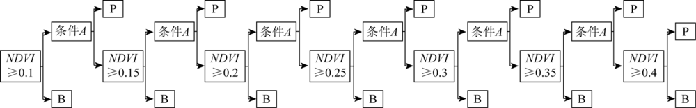
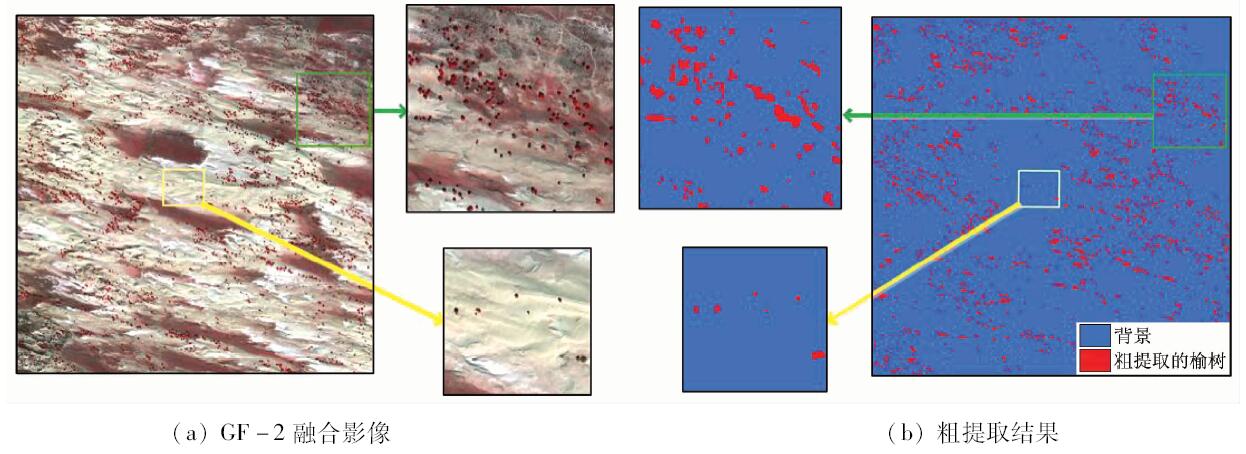
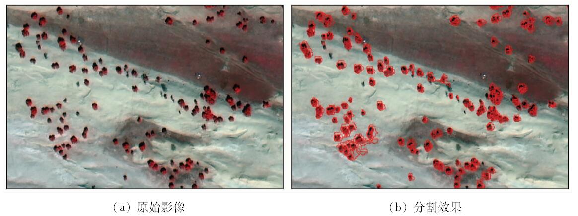
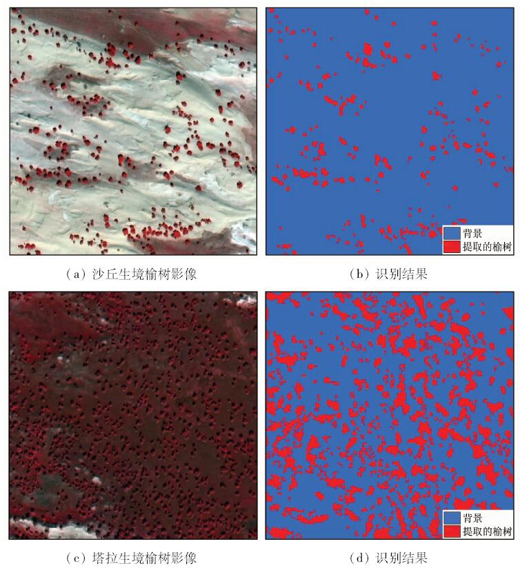
Abstract The elm sparse forest is an important component in the Otindag sandy land ecosystem, which is of great significance for windbreak and sand fixation. In order to obtain the spatial distribution information of elm trees quickly and accurately, this paper proposes a method of automatic sand elm identification based on remote sensing technology. With the data of domestic high spatial resolution satellite GF-2, the research was implemented on Zhenglan Banner, Xilin Gol League, Inner Mongolia. Combined with the characteristics of elm sparse distribution in the sand, normalizd difference vegetation index (NDVI) threshold was firstly used to quickly extract the coarse distribution of elm. Then, a method based on geographic object based image analysis (GEOBIA) was used to extract the distribution of elm accurately. To compensate for the uncertainty of GEOBIA method in feature selection and rule set construction, this study used SEaTH algorithm to optimize features and automatically calculate the feature threshold. The results show that the proposed methods reached the overall accuracy of 88.17% and Kappa coefficient of 0.76 in identifying the sparse elm. Among them, elm mapping accuracy could reach 99.14%. Therefore, it is effective to identify elms by using GF-2 and the method proposed in this study. This method can provide technical support for the further research and production practices of elm sparse forest in the Otindag sandy land.
|
| Keywords
Otindag sandy land
elm
sparse
GF-2
GEOBIA
SEaTH
|
|
|
|
Corresponding Authors:
Zhihai GAO
E-mail: zhgao@caf.ac.cn
|
|
Issue Date: 07 December 2018
|
|
|
| [1] |
彭羽, 蒋高明, 郭泺 , 等. 浑善达克沙地中部榆树疏林景观格局[J]. 科技导报, 2011,29(25):45-47.
doi: 10.3981/j.issn.1000-7857.2011.25.006
url: http://d.wanfangdata.com.cn/Periodical/kjdb201125010
|
| [1] |
Peng Y, Jiang G M, Guo L , et al. Landscape pattern of elm open forest in the center part of Hunshandake sandland[J]. Science Technology Review, 2011,29(25):45-47.
|
| [2] |
于顺利, 陈宏伟 . 内蒙古高原温带稀树草原生态系统特征与成因[J]. 生态学杂志, 2007,26(4):549-554.
url: http://www.cqvip.com/Main/Detail.aspx?id=24353749
|
| [2] |
Yu S L, Chen H W . Characteristics and formation causes of temperate sparse forest grassland ecosystem in Inner Mongolia Plateau[J]. Chinese Journal of Ecology, 2007,26(4):549-554.
|
| [3] |
李永庚, 蒋高明, 高雷明 , 等. 人为干扰对浑善达克沙地榆树疏林的影响[J]. 植物生态学报, 2003,27(6):829-834.
doi: 10.17521/cjpe.2003.0119
url: http://d.wanfangdata.com.cn/Periodical/zwstxb200306016
|
| [3] |
Li Y G, Jiang G M, Gao L M , et al. Impacts of human disturbance on elms-motte-veldt in Hunshandak sandland[J]. Acta Phytoecologica Sinica, 2003,27(6):829-835.
|
| [4] |
牛海亮 . 浑善达克沙地榆树疏林榆树种群特征分析[D]. 呼和浩特:内蒙古大学, 2008.
|
| [4] |
Niu H L . Analysis of Population Characteristics of Ulmus Pumila Sparse Forest in Hunshandake Sandy Land[D]. Hohhot:Inner Mongolia Agricultural University, 2008.
|
| [5] |
赵国青 . 正蓝旗古榆树种群特征及林下植物多样性的研究[D]. 呼和浩特:内蒙古农业大学, 2011.
|
| [5] |
Zhao G Q . Study on the Population Characteristics of Ancience Elm in Zhenglan Banner[D]. Hohhot:Inner Mongolia Agricultural University, 2011.
|
| [6] |
李钢铁, 姚云峰, 左合君 . 浑善达克沙地桑根达来地区榆树疏林的分布与立地因子的关系的研究[J]. 世界林业研究, 2008,21:82-86.
url: http://d.wanfangdata.com.cn/Conference/7142115
|
| [6] |
Li G T, Yao Y F, Zuo H J . Study on the relation between growth and site of Ulmus pumila L.var.sabulosa J.H.Guo in Otingdag sandy land[J]. World Forestry Research, 2008,21:82-86.
|
| [7] |
顾海燕, 闫利, 李海涛 , 等. 基于随机森林的地理要素面向对象自动解译方法[J]. 武汉大学学报(信息科学版), 2016,41(2):228-234.
doi: 10.13203/j.whugis20140102
url: http://www.cqvip.com/QK/92848A/201602/667775450.html
|
| [7] |
Gu H Y, Yan L, Li H T , et al. An object-based automatic interpretation method for geographic features based on random forest machine learning[J]. Geomatics and Information Science of Wuhan University, 2016.
|
| [8] |
Laliberte A S, Fredrickson E L, Rango A . Combining decision trees with hierarchical object-oriented image analysis for mapping arid rangelands[J]. Photogrammetric engineering and Remote sensing, 2007,73(2):197-207.
doi: 10.14358/PERS.73.2.197
url: http://openurl.ingenta.com/content/xref?genre=article&issn=0099-1112&volume=73&issue=2&spage=197
|
| [9] |
Gibbes C, Adhikari S, Rostant L , et al. Application of object based classification and high resolution satellite imagery for savanna ecosystem analysis[J]. Remote Sensing, 2010,2(12):2748-2772.
doi: 10.3390/rs2122748
url: http://www.mdpi.com/2072-4292/2/12/2748
|
| [10] |
Boggs G S . Assessment of SPOT 5 and QuickBird remotely sensed imagery for mapping tree cover in savannas[J]. International journal of applied earth observation and geoinformation, 2010,12(4):217-224.
doi: 10.1016/j.jag.2009.11.001
url: http://linkinghub.elsevier.com/retrieve/pii/S0303243409001068
|
| [11] |
施敏燕, 郭春雷, 杨小婷 , 等. 基于Quickbird影像的额济纳胡杨林树冠提取[J].科技创新导报, 2011(5):13-15.
|
| [11] |
Shi M Y, Guo C L, Yang X T , et al. Canopy extraction of Populus euphratica forest in Ejina based on Quickbird image[J].Science and Technology innovation Heraid,2011(5):13-15.
|
| [12] |
张靖媛 . 浑善达克沙地桑根达来地区榆树疏林林草特征的研究[D]. 呼和浩特:内蒙古农业大学, 2009.
|
| [12] |
Zhang J Y . Studies on Characteristics of Trees and Grass Ulmus pumila L.var.sabulosa Woodland of Sanggendalai in Hunshandake Sandy Land[D]. Hohhot:Inner Mongolia Agricultural University, 2009.
|
| [13] |
徐文铎 . 中国沙地森林生态系统[M]. 北京: 中国林业出版社, 1998.
|
| [13] |
Xu W D. Sandy Forest Ecosystem of China[M]. Beijing: China Forestry Publishing House, 1998.
|
| [14] |
Whiteside T G, Boggs G S, Maier S W . Extraction of tree crowns from high resolution imagery over Eucalypt dominant tropical savannas[J]. Photogrammetric Engineering and Remote Sensing, 2011,77(8):813-824.
doi: 10.14358/PERS.77.8.813
url: http://openurl.ingenta.com/content/xref?genre=article&issn=0099-1112&volume=77&issue=8&spage=813
|
| [15] |
Karlson M, Reese H, Ostwald M . Tree crown mapping in managed woodlands (parklands) of semi-arid West Africa using WorldView-2 imagery and geographic object based image analysis[J]. Sensors, 2014,14(12):22643-22669.
doi: 10.3390/s141222643
pmid: 25460815
url: http://www.mdpi.com/1424-8220/14/12/22643
|
| [16] |
Nussbaum S, Niemeyer I, Canty M J. SEATH-a new tool for automated feature extraction in the context of object-based image analysis [C]//1st International Conference on Object-based Image Analysis (OBIA).Salzburg:Austria. 2006.
|
| [17] |
余晓敏, 湛飞并, 廖明生 , 等. 利用改进SEaTH算法的面向对象分类特征选择方法[J]. 武汉大学学报(信息科学版), 2012,37(8):921-924.
|
| [17] |
Yu X M, Zhan F B, Liao M S , et al. Object-oriented feature selection algorithms based on improved SEaTH algorithms[J]. Geomatics and Information Science of Wuhan University, 2012,37(8):921-924.
|
| [18] |
Marpu P R, Niemeyer I, Nussbaum S , et al. A procedure for automatic object-based classification[J]. Lecture Notes in Geoinformation and Cartography, 2008: 169-184.
doi: 10.1007/978-3-540-77058-9_9
url: http://link.springer.com/10.1007/978-3-540-77058-9_9
|
| [19] |
Ren D, Abdelsalam M G. Optimum index factor (OIF) for ASTER data:Examples from the Neoproterozoic Allaqi Suture,Egypt [C]//Geological Society of American Annual Meeting. 2001: 289-290.
|
|
Viewed |
|
|
|
Full text
|
|
|
|
|
Abstract
|
|
|
|
|
Cited |
|
|
|
|
| |
Shared |
|
|
|
|
| |
Discussed |
|
|
|
|
 2018,
Vol. 30
2018,
Vol. 30
 ), Bin SUN, Changlong LI, Yan WANG, Yuanyuan ZHANG