Please wait a minute...
 
Remote Sensing for Land & Resources    2019, Vol. 31 Issue (3) : 209-215     DOI: 10.6046/gtzyyg.2019.03.26
|
Analysis of the variations of the lake ice phenology in the Pangong Lake area from 2013 to 2017: Remote sensing survey of the cryosphere in the high altitude and alpine region, West China(Ⅰ)
Yunpeng YAN1, Hui XU2(), Gang LIU1, Jianyu LIU1
1. China Aero Geophysical Survey and Remote Sensing Center for Natural Resources, Beijing 100083, China
2. State Key Laboratory of Numerical Modeling for Atmospheric Sciences and Geophysical Fluid Dynamics (LASG),Institute of Atmospheric Physics, Chinese Academy of Sciences, Beijing 100029, China
Download: PDF(1974 KB)   HTML
Export: BibTeX | EndNote | Reference Manager | ProCite | RefWorks    
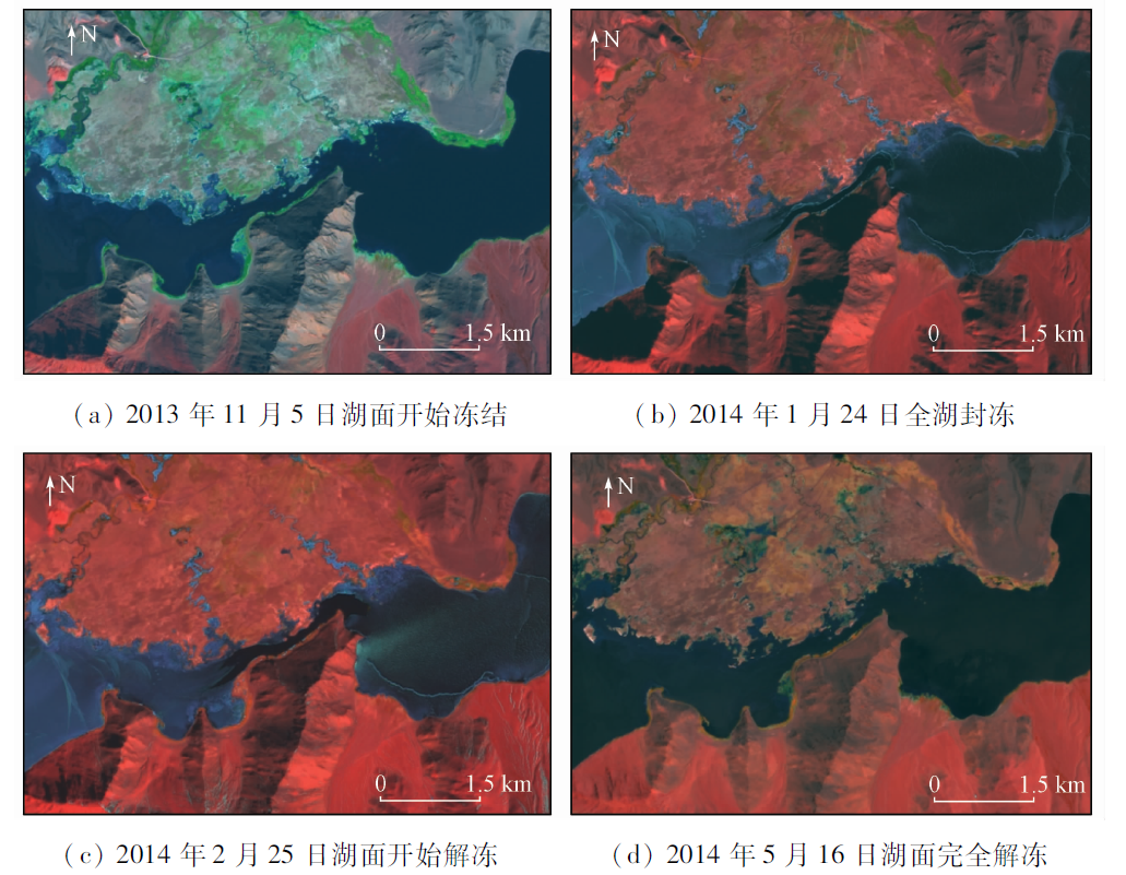
Abstract  

The analysis of the lake ice phenology in the high altitude and alpine area is of great significance for traffic capacity assessment on the lake ice in the cold season, disaster prevention and reduction of moraine lake burst and prediction on the flood disaster of the lower reaches in the warm season. On the basis of the OLI data from 2013 to 2017, four typical lakes(areas)in the Pangong Lake area were chosen for the analysis of the lake ice phenology in winter. The results show that the starting freeze time, the time of maximum ice amount, starting thaw time and totally thaw time of Zone1 and Zone2 in the Pangong Lake were almost simultaneous. Although Spanggur Lake and Moriri Lake both have higher altitude than Pangong Lake, and they shared the similar freeze processes. The starting thaw time of Spanggur Lake was later than Pangong Lake, while the totally thaw time was almost the same. The starting thaw time of Moriri Lake was about half to one month later than that of Pangong Lake, and the totally thaw time was one month later than other three lakes.

Keywords West China      high altitude and alpine region      cryosphere      remote sensing      lake      ice phenology      Pangong Lake     
:  TP79  
Corresponding Authors: Hui XU     E-mail: xuh@lasg.iap.ac.cn
Issue Date: 30 August 2019
Service
E-mail this article
E-mail Alert
RSS
Articles by authors
Yunpeng YAN
Hui XU
Gang LIU
Jianyu LIU
Cite this article:   
Yunpeng YAN,Hui XU,Gang LIU, et al. Analysis of the variations of the lake ice phenology in the Pangong Lake area from 2013 to 2017: Remote sensing survey of the cryosphere in the high altitude and alpine region, West China(Ⅰ)[J]. Remote Sensing for Land & Resources, 2019, 31(3): 209-215.
URL:  
https://www.gtzyyg.com/EN/10.6046/gtzyyg.2019.03.26     OR     https://www.gtzyyg.com/EN/Y2019/V31/I3/209
Fig.1  Lake distribution in the research area
期次 本期次起止时间 本期次时
间跨度
与前一期次
的间隔
期次 本期次起止时间 本期次时
间跨度
与前一期次
的间隔
1 1105—1116 12 8 次年0302—次年0313 12 16
2 1121—1202 12 16 9 次年0318—次年0321 4 12
3 1207—1218 12 16 10 次年0329—次年0403 6 12
4 1223—次年0103 12 16 11 次年0411—次年0422 12 16
5 次年0111—次年0124 14 20 12 次年0503—次年0516 14 23
6 次年0130—次年0212 14 19 13 次年0519—次年0529 11 14
7 次年0215—次年0225 11 14
Tab.1  Landsat8 remote sensing image periods(d)
湖泊名称 中心坐标 湖水面
积/km2
湖面高
程/m
经度 纬度
班公湖Zone1区 E79.00° N33.74° 39 4 245
班公湖Zone2区 E79.62° N33.67° 45 4 245
斯潘古尔湖 E78.90° N33.50° 58 4 296
莫里里湖 E78.30° N32.90° 144 4 527
Tab.2  Main properties of monitoring objects
年度 第1期
(1111)
第2期
(1127)
第3期
(1213)
第4期
(1229)
第5期
(次年0118)
第6期
(次年0206)
第7期
(次年0220)
2013—2014年 20131105 20131121 20131207 20131223 20140124 20140209 20140225
2014—2015年 20141108C 20141124 20141210 20141226 20150111 20150212
2015—2016年 20151111 20151213 20151229 20160114C 20160130C 20160215
2016—2017年 20161113 20161129 20161215 20161231 20170115T 20170201 20170217
年度 第8期
(次年0308)
第9期
(次年0320)
第10期
(次年0401)
第11期
(次年0417)
第12期
(次年0501)
第13期
(次年0515)
2013—2014年 20140313 20140329 20140414 20140516
2014—2015年 20150401 20150417 20150503 20150519
2015—2016年 20160302 20160318 20160403 20160419 20160505 20160521
2016—2017年 20170305 20170321 20170422 20170508
Tab.3  Interannual dynamic changes of lake ice in cold season for Bangong Lake Zone1 Area
Fig.2  Remote sensing image characteristics of lake ice dynamic changes in partial areas of Pangong Lake Zone1 in cold season 2013—2014
湖泊(区域)冰情
变化基本参数
班公湖
Zone1区
班公湖
Zone2区
斯潘古
尔湖
莫里
里湖
冻结开始时间(最早) 1105 1105 1105 1105
冻结开始时间(最晚) 1113 1113 1113 1113
冻结开始时间跨度/d 9 9 9 9
封冻开始时间(最早) 次年
0111
1226 1229 次年
0111
封冻开始时间(最晚) 次年
0124
次年
0124
次年
0124
次年
0201
湖泊(区域)冰情
变化基本参数
班公湖
Zone1区
班公湖
Zone2区
斯潘古
尔湖
莫里
里湖
封冻开始时间跨度/d 14 30 27 22
解冻开始时间(最早) 次年
0217
次年
0215
次年
0318
次年
0422
解冻开始时间(最晚) 次年
0401
次年
0401
次年
0417
次年
0519
解冻开始时间跨度/d 44 46 31 28
完全解冻开始时间(最早) 次年
0505
次年
0505
次年
0505
次年
0604
完全解冻开始时间(最晚) 次年
0519
次年
0519
次年
0519
次年
0617
完全解冻开始时间跨度/d 15 15 15 14
冰冻期时长(最长)/d 196 196 196 225
冰冻期时长(最短)/d 174 174 174 204
Tab.4  Interannual dynamic changes of lake ice in cold season for Pangong Lake area
[1] 杨倩, 吕德昊 . 湖冰物候变化遥感监测研究进展[J].科技风, 2017(17):116-117.
[1] Yang Q, Lyu D H . Progress in remote sensing monitoring of lake ice phenology[J].Technology Wind, 2017(17):116-117.
[2] 燕云鹏, 刘刚, 李瑜 , 等. 西北边境地区冰冻圈遥感调查与监测(2013—2015)主要进展[J]. 中国地质调查, 2017,4(3):51-56.
[2] Yan Y P, Liu G, Li Y , et al. Research achievements on cryosphere investigation and monitoring using remote sensing techniques in the northwest border area from 2013 to 2015[J]. Geological Survey of China, 2017,4(3):51-56.
[3] 曹梅盛, 李新, 陈贤章 , 等. 冰冻圈遥感[M]. 北京: 科学出版社, 2006.
[3] Cao M S, Li X, Chen X Z , et al. Remote Sensing of Cryosphere[M]. Beijing: Science Press, 2006.
[4] 辛羽飞, 卞林根 . 全球冰冻圈变化预测研究现状[J]. 极地研究, 2008,20(3):275-286.
doi: CNKI:SUN:JDYZ.0.2008-03-007
[4] Xin Y F, Bian L G . Progress of prediction of the global cryosphere change[J]. Chinese Journal of Polar Research, 2008,20(3):275-286.
[5] 魏秋芳, 叶庆华 . 湖冰遥感监测方法综述[J]. 地理科学进展, 2010,29(7):803-810.
doi: 10.11820/dlkxjz.2010.07.005
[5] Wei Q F, Ye Q H . Review of lake ice monitoring by remote sensing[J]. Progress in Geogrphy, 2010,29(7):803-810.
[6] 陈贤章, 王光宇, 李文君 , 等. 青藏高原湖冰及其遥感监测[J]. 冰川冻土, 1995,17(3):241-246.
[6] Chen X Z, Wang G Y, Li W J , et al. Lake ice and its remote sensing monitoring in the Tibetan Plateau[J]. Journal of Glaciology and Geocryology, 1995,17(3):241-246.
[7] 王智颖, 吴艳红, 常军 , 等. 青藏高原湖冰物候的时空变化及其影响因素[J]. 北京工业大学学报, 2017,43(5):701-709.
[7] Wang Z Y, Wu Y H, Chang J , et al. Temporal and spatial variation of lake ice phenology and its influencing factor in the Tibetan Plateau[J]. Journal of Beijing University of Technology, 2017,43(5):701-709.
[8] 姚晓军, 李龙, 赵军 , 等. 近10年来可可西里地区主要湖泊冰情时空变化[J]. 地理学报, 2015,70(7):1114-1124.
[8] Yao X J, Li L, Zhao J , et al. Spatial-temporal variations of lake ice in the Hoh Xil region from 2000 to 2011[J]. Acta Geographic Sinica, 2015,70(7):1114-1124.
[9] 赵水霞, 李畅游, 李超 , 等. 黄河什四份子弯道河冰生消及冰塞过程分析[J]. 水利学报, 2017,48(3):351-358.
doi: 10.13243/j.cnki.slxb.20160721
[9] Zhao S X, Li C Y, Li C , et al. Processes of river ice and ice-jam formation in Shensifenzi bend of the Yellow River[J]. Journal of Hydraulic Engineering, 2017,48(3):351-358.
[10] 李超, 李畅游, 赵水霞 , 等, 基于遥感数据的河冰过程解译及分析[J]. 水利水电科技进展, 2016,36(3):52-56.
[10] Li C, Li C Y, Zhao S X , et al. Interpretation and analysis of river ice process based on remote sensing data[J]. Advances in Science and Technology of Water Resources, 2016,36(3):52-56.
[11] 李均力, 盛永伟, 骆剑承 . 喜马拉雅山地区冰湖信息的遥感自动化提取[J]. 遥感学报, 2011,15(1):29-43.
doi: 10.11834/jrs.20110103
[11] Li J L, Sheng Y W, Luo J C , et al. Automatic extaction of Himalayan glacial lakes with remote sensing[J]. Journal of Remote Sensing, 2011,15(1):29-43.
[1] LI Weiguang, HOU Meiting. A review of reconstruction methods for remote-sensing-based time series data of vegetation and some examples[J]. Remote Sensing for Natural Resources, 2022, 34(1): 1-9.
[2] DING Bo, LI Wei, HU Ke. Inversion of total suspended matter concentration in Maowei Sea and its estuary, Southwest China using contemporaneous optical data and GF SAR data[J]. Remote Sensing for Natural Resources, 2022, 34(1): 10-17.
[3] GAO Qi, WANG Yuzhen, FENG Chunhui, MA Ziqiang, LIU Weiyang, PENG Jie, JI Yanzhen. Remote sensing inversion of desert soil moisture based on improved spectral indices[J]. Remote Sensing for Natural Resources, 2022, 34(1): 142-150.
[4] ZHANG Qinrui, ZHAO Liangjun, LIN Guojun, WAN Honglin. Ecological environment assessment of three-river confluence in Yibin City using improved remote sensing ecological index[J]. Remote Sensing for Natural Resources, 2022, 34(1): 230-237.
[5] HE Peng, TONG Liqiang, GUO Zhaocheng, TU Jienan, WANG Genhou. A study on hidden risks of glacial lake outburst floods based on relief amplitude: A case study of eastern Shishapangma[J]. Remote Sensing for Natural Resources, 2022, 34(1): 257-264.
[6] LIU Wen, WANG Meng, SONG Ban, YU Tianbin, HUANG Xichao, JIANG Yu, SUN Yujiang. Surveys and chain structure study of potential hazards of ice avalanches based on optical remote sensing technology: A case study of southeast Tibet[J]. Remote Sensing for Natural Resources, 2022, 34(1): 265-276.
[7] WANG Qian, REN Guangli. Application of hyperspectral remote sensing data-based anomaly extraction in copper-gold prospecting in the Solake area in the Altyn metallogenic belt, Xinjiang[J]. Remote Sensing for Natural Resources, 2022, 34(1): 277-285.
[8] LYU Pin, XIONG Liyuan, XU Zhengqiang, ZHOU Xuecheng. FME-based method for attribute consistency checking of vector data of mines obtained from remote sensing monitoring[J]. Remote Sensing for Natural Resources, 2022, 34(1): 293-298.
[9] ZHANG Daming, ZHANG Xueyong, LI Lu, LIU Huayong. Remote sensing image segmentation based on Parzen window density estimation of super-pixels[J]. Remote Sensing for Natural Resources, 2022, 34(1): 53-60.
[10] XUE Bai, WANG Yizhe, LIU Shuhan, YUE Mingyu, WANG Yiying, ZHAO Shihu. Change detection of high-resolution remote sensing images based on Siamese network[J]. Remote Sensing for Natural Resources, 2022, 34(1): 61-66.
[11] SONG Renbo, ZHU Yuxin, GUO Renjie, ZHAO Pengfei, ZHAO Kexin, ZHU Jie, CHEN Ying. A method for 3D modeling of urban buildings based on multi-source data integration[J]. Remote Sensing for Natural Resources, 2022, 34(1): 93-105.
[12] YU Xinli, SONG Yan, YANG Miao, HUANG Lei, ZHANG Yanjie. Multi-model and multi-scale scene recognition of shipbuilding enterprises based on convolutional neural network with spatial constraints[J]. Remote Sensing for Natural Resources, 2021, 33(4): 72-81.
[13] LI Yikun, YANG Yang, YANG Shuwen, WANG Zihao. A change vector analysis in posterior probability space combined with fuzzy C-means clustering and a Bayesian network[J]. Remote Sensing for Natural Resources, 2021, 33(4): 82-88.
[14] AI Lu, SUN Shuyi, LI Shuguang, MA Hongzhang. Research progress on the cooperative inversion of soil moisture using optical and SAR remote sensing[J]. Remote Sensing for Natural Resources, 2021, 33(4): 10-18.
[15] LI Teya, SONG Yan, YU Xinli, ZHOU Yuanxiu. Monthly production estimation model for steel companies based on inversion of satellite thermal infrared temperature[J]. Remote Sensing for Natural Resources, 2021, 33(4): 121-129.
Viewed
Full text


Abstract

Cited

  Shared   
  Discussed   
京ICP备05055290号-2
Copyright © 2017 Remote Sensing for Natural Resources
Support by Beijing Magtech