|
|
 |
|

|
|
|
Remote sensing image semantic segmentation using deep fusion convolutional networks and conditional random field |
LI Yu1( ), XIAO Chunjiao1, ZHANG Hongqun1(), LI Xiangjuan2, CHEN Jun1 ), XIAO Chunjiao1, ZHANG Hongqun1(), LI Xiangjuan2, CHEN Jun1 |
1. Institute of Remote Sensing and Digital Earth, Chinese Academy of Sciences, Beijing 100094, China
2. School of Computer Science, Xi’an Shiyou University, Xi’an 710065, China |
|
|
|
|
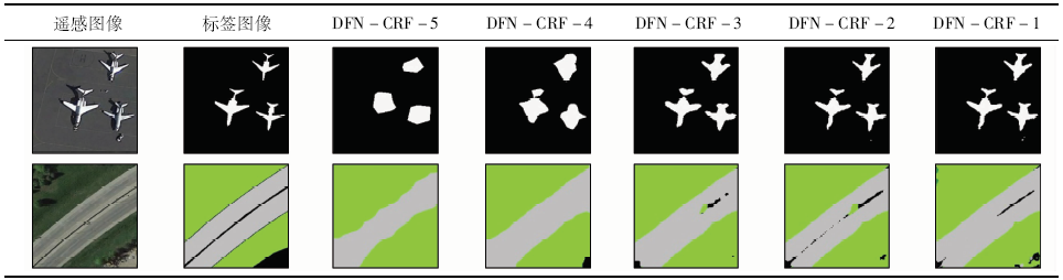
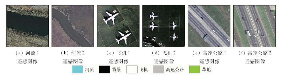
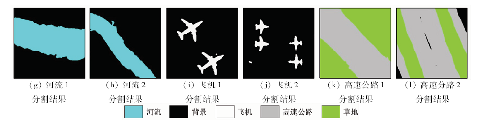
Abstract A method for remote sensing image semantic segmentation based on deep fusion convolutional networks and conditional random field is proposed. First, the fully convolutional networks framework with deconvolutional fusion structure is utilized to integrate the pooling-layer results at different levels. The low-level features with rich detail information are combined with the high-level features via deconvolutional fusion module. At the same time, the parameter inference process of conditional random field is embedded in the network architecture by adding recurrent neural networks iteration layers. In addition, the deep fusion convolutional networks and conditional random field model is established. Then, in the model training stage, the abundant detail information and context information in the image are introduced simultaneously to the positive and negative propagation. And lastly, the remote sensing image semantic segmentation is accomplished by the end-to-end framework. Semantic segmentation experiments were performed on the high-resolution optical remote sensing images, and the results show that, with the increase of the depth of deconvolution fusion layer in the model, semantic segmentation results are more refined, and the contour of terrestrial object is more accurate. The introduction of context information also improves the accuracy of image semantic segmentation to a certain extent. It is concluded that the proposed method can better maintain the consistency of internal areas of semantic object and effectively improve the accuracy of semantic segmentation.
|
| Keywords
remote sensing image
semantic segmentation
fully convolutional networks
conditional random field
|
|
|
|
Corresponding Authors:
ZHANG Hongqun
E-mail: liyu@radi.ac.cn;zhanghq@aircas.ac.cn
|
|
Issue Date: 09 October 2020
|
|
|
| [1] |
魏云超, 赵耀. 基于DCNN的图像语义分割综述[J]. 北京交通大学学报, 2016,40(4):82-91.
|
| [1] |
Wei Y C, Zhao Y. A review on image semantic segmentation based on DCNN[J]. Journal of Beijing Jiaotong University, 2016,40(4):82-91.
|
| [2] |
罗冰. 语义对象分割方法研究[D]. 成都:电子科技大学, 2018.
|
| [2] |
Luo B. Research on segmentation of semantic objects[D]. Chengdu:University of Electronic Science and Technology of China, 2018.
|
| [3] |
韩铮, 肖志涛. 基于纹元森林和显著性先验的弱监督图像语义分割方法[J]. 电子与信息学报, 2018,40(3):610-617.
|
| [3] |
Han Z, Xiao Z T. Weakly supervised semantic segmentation based on semantic texton forest and saliency prior[J]. Journal of Electronics & Information Technology, 2018,40(3):610-617.
|
| [4] |
Zhao J, Zhong Y F, Zhang L P. Detail-preserving smoothing classifier based on conditional random fields for high spatial resolution remote sensing imagery[J]. IEEE Transactions on Geoscience & Remote Sensing, 2015,53(5):2440-2452.
|
| [5] |
叶发茂, 罗威, 苏燕飞, 等. 卷积神经网络特征在遥感图像配准中的应用[J]. 国土资源遥感, 2019,31(2):32-37.doi: 10.6046/gtzyyg.2019.02.05.
|
| [5] |
Ye F M, Luo W, Su Y F, et al. Application of convolutional neural network feature to remote sensing image registration[J]. Remote Sensing for Land and Resources, 2019,31(2):32-37.doi: 10.6046/gtzyyg.2019.02.05.
|
| [6] |
Zhao W D, Li S S, Li A, et al. Hyperspectral images classification with convolutional neural network and textural feature using limited training samples[J]. Remote Sensing Letters, 2019,10(5):449-458.
doi: 10.1080/2150704X.2019.1569274
url: https://www.tandfonline.com/doi/full/10.1080/2150704X.2019.1569274
|
| [7] |
张康, 黑保琴, 李盛阳, 等. 基于CNN模型的遥感图像复杂场景分类[J]. 国土资源遥感, 2018,30(4):49-55.doi: 10.6046/gtzyyg.2018.04.08.
|
| [7] |
Zhang K, Hei B Q, Li S Y, et al. Complex scene classification of remote sensing images based on CNN[J]. Remote Sensing for Land and Resources, 2018,30(4):49-55.doi: 10.6046/gtzyyg.2018.04.08.
|
| [8] |
Zhang R, Li G Y, Li M L, et al. Fusion of images and point clouds for the semantic segmentation of large-scale 3D scenes based on deep learning[J]. ISPRS Journal of Photogrammetry and Remote Sensing, 2018,143:85-96.
doi: 10.1016/j.isprsjprs.2018.04.022
url: https://linkinghub.elsevier.com/retrieve/pii/S0924271618301291
|
| [9] |
Kanmffmeyer M, Salberg A B, Jenssen R. Semantic segmentation of small objects and modeling of uncertainty in urban remote sensing images using deep convolutional neural networks [C]//Proceedings of Computer Vision and Pattern Recognition Workshops. 2016: 680-688.
|
| [10] |
Long J, Shelhamer E, Darrell T. Fully convolutional networks for semantic segmentation [C]//IEEE Conference on Computer Vision and Pattern Recognition.IEEE, 2015: 3431-3440.
|
| [11] |
Sherrah J. Fully convolutional networks for dense semantic labelling of high-resolution aerial imagery[EB/OL].(2016-06-08)[2019-08-16]. http://arxiv.org/abs/1606.02585v1.
url: http://arxiv.org/abs/1606.02585v1
|
| [12] |
Badrinarayanan V, Handa A, Cipolla R. SegNet:A deep convolutional encoder-decoder architecture for robust semantic pixel-wise labelling[J]. IEEE Transactions on Pattern Analysis and Machine Intelligence, 2017,309(12):2481-2495.
|
| [13] |
Ronneberger O, Fischer P, Brox T. U-Net:Convolutional networks for biomedical image segmentation [C]//Proceedings of the International Conference on Medical Image Computing and Computer-Assisted Intervention.Berlin:Springer, 2015: 234-241.
|
| [14] |
Chen L C, Papandreou G, Kokkinos L, et al. DeepLab:semantic image segmentation with deep convolutional nets,atrous convolution,and fully connected CRFs[J]. IEEE Transactions on Pattern Analysis and Machine Intelligence, 2016,40(4):834-848.
doi: 10.1109/TPAMI.2017.2699184
pmid: 28463186
url: https://www.ncbi.nlm.nih.gov/pubmed/28463186
|
| [15] |
Zheng S, Jayasumana S, Romera-Paredes B, et al. Conditional random fields as recurrent neural networks [C]//IEEE International Conference on Computer Vision. 2015: 1529-1537.
|
| [16] |
Lafferty J, Mccallum A, Pereira F. Conditional random fields:Probabilistic models for segmenting and labeling sequence data [C]//Eighteenth International Conference on Machine Learning. 2001,3(2):282-289.
|
| [17] |
Hammersley J M, Clifford P. Markov fields on finite graphs and lattices[EB/OL].[ 2012- 01- 30]. http://www.statslab.cam.ac.uk/~grg/books/hammfest/hamm-cliff.pdf.
url: http://www.statslab.cam.ac.uk/~grg/books/hammfest/hamm-cliff.pdf
|
| [18] |
Krahenbuhl P, Koltun V. Efficient inference in fully connected CRFs with gaussian edge potentials [C]//Proceeding NIPS’11 Proceeding of the 24th International Conference on Neural Information Processing Systems Advances in Neural Information Processing Systems. 2011: 109-117.
|
| [19] |
Cheng G, Han J, Lu X Q. Remote sensing image scene classification:benchmark and state of the art [C]//Proceedings of the IEEE. 2017,105(10):1865-1883.
|
| [20] |
Yang Y, Newsam S. Bag-of-visual-words and spatial extensions for land-use classification [C]//Proceedings of the 18th Sigspatial International Conference on Advances in Geographic Information Systems. 2010: 270-279.
|
| [21] |
Alberto G G, Sergio O E, Sergiu O, et al. A review on deep learning techniques applied to semantic segmentation[EB/OL].(2017-04-22)[2019-08-16]. http://arxiv.org/abs/1704.06857.
url: http://arxiv.org/abs/1704.06857
|
|
Viewed |
|
|
|
Full text
|
|
|
|
|
Abstract
|
|
|
|
|
Cited |
|
|
|
|
| |
Shared |
|
|
|
|
| |
Discussed |
|
|
|
|
 2020,
Vol. 32
2020,
Vol. 32