|
|
|
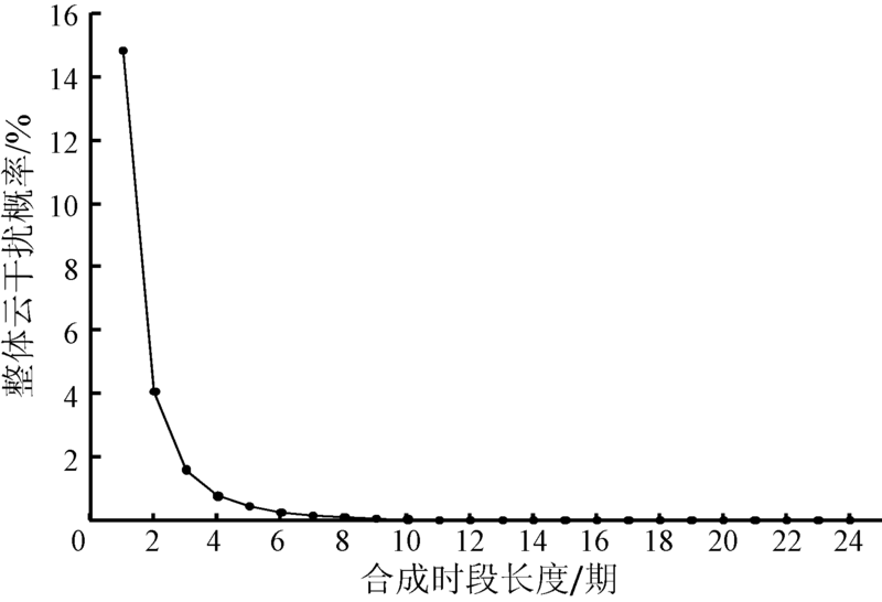
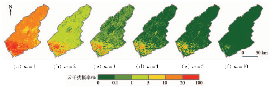
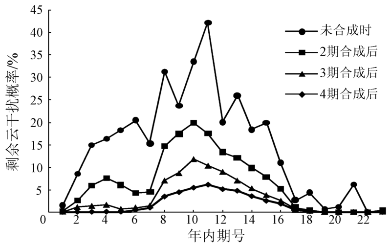
Abstract In this paper, the authors aim to clarify the spatio-temporal patterns of cloud interference in Dongjiang River basin and then provide scientific basis for vegetation index studies at the level of higher precision in this area. Cloud flag information of MOD13Q1 product data sets within the range of Dongjiang River basin from 2001 to 2015 were analyzed using the GIS approach. Three aspects were analyzed, i.e., the probability of cloud interference and its spatial distribution, the elimination rate of cloud interference and its spatial distribution and the seasonal differences of cloud interference duration period length. The results show that the whole probability of cloud interference was reduced rapidly with the increase of compounding period length, the new added elimination rate of cloud interference firstly increased and then decreased with the increase of compounding period length. The duration period length of cloud interference was relatively longer in southern urbanized region, and in summer and spring. The results of this study can provide scientific basis for choosing or developing better methods of removing clouds for vegetation index time-series data.
|
| Keywords
Dongjiang River basin
MODIS
cloud flag
cloud interference
|
|
|
|
Issue Date: 08 February 2018
|
|
|
| [1] |
赵敏,张荣,尹东,等.一种新的可见光遥感图像云判别算法[J].遥感技术与应用,2012,27(1):106-110.
|
| [1] |
Zhao M,Zhang R,Yin D,et al.Cloud classification algorithm for optical remote sensing image[J].Remote Sensing Technology and Application,2012,27(1):106-110.
|
| [2] |
陈阳,范建容,文学虎,等.基于时空数据融合模型的TM影像云去除方法研究[J].遥感技术与应用,2015,30(2):312-320.
|
| [2] |
Chen Y,Fan J R,Wen X H,et al.Research on cloud removal from Landsat TM image based on spatial and temporal data fusion model[J].Remote Sensing Technology and Application,2015,30(2):312-320.
|
| [3] |
徐昔保,杨桂山.太湖流域1995—2010年耕地复种指数时空变化遥感分析[J].农业工程学报,2013,29(3):148-155.
|
| [3] |
Xu X B,Yang G S.Spatial and temporal changes of multiple cropping index in 1995—2010 in Taihu Lake basin, China[J].Transactions of the Chinese Society of Agricultural Engineering,2013,29(3):148-155.
|
| [4] |
蒙继华,杜鑫,张淼,等.物候信息在大范围作物长势遥感监测中的应用[J].遥感技术与应用,2014,29(2):278-285.
|
| [4] |
Meng J H,Du X,Zhang M,et al.Integrating crop phenophase information in large-area crop condition evaluation with remote sensing[J].Remote Sensing Technology and Application,2014,29(2):278-285.
|
| [5] |
张喜旺,吴炳方.基于中高分辨率遥感的植被覆盖度时相变换方法[J].生态学报,2015,35(4):1155-1164.
|
| [5] |
Zhang X W,Wu B F.A temporal transformation method of fractional vegetation cover derived from high and moderate resolution remote sensing data[J].Acta Ecologica Sinica,2015,35(4):1155-1164.
|
| [6] |
Holben B N.Characteristics of maximum-value composite images from temporal AVHRR data[J].International Journal of Remote Sensing,1986,7(11):1417-1434.
|
| [7] |
武正丽,贾文雄,刘亚荣,等.近10a来祁连山植被覆盖变化研究[J].干旱区研究,2014,31(1):80-87.
|
| [7] |
Wu Z L,Jia W X,Liu Y R,et al.Change of vegetation coverage in the Qilian Mountains in recent 10 years[J].Arid Zone Research,2014,31(1):80-87.
|
| [8] |
宋富强,邢开雄,刘阳,等.基于MODIS/NDVI的陕北地区植被动态监测与评价[J].生态学报,2011,31(2):354-363.
|
| [8] |
Song F Q,Xing K X,Liu Y,et al.Monitoring and assessment of vegetation variation in northern Shaanxi based on MODIS/NDVI[J].Acta Ecologica Sinica,2011,31(2):354-363.
|
| [9] |
Viovy N,Arino O,Belward A S.The best index slope extraction(BISE):A method for reducing noise in NDVI time-series[J].International Journal of Remote Sensing,1992,13(8):1585-1590.
|
| [10] |
Lovell J L,Graetz R D.Filtering pathfinder AVHRR land NDVI data for Australia[J].International Journal of Remote Sensing,2001,22(13):2649-2654.
|
| [11] |
Roerink G J,Menenti M,Verhoef W.Reconstructing cloudfree NDVI composites using Fourier analysis of time series[J].International Journal of Remote Sensing,2000,21(9):1911-1917.
|
| [12] |
Jonsson P,Eklundh L.Seasonality extraction by function fitting to time-series of satellite sensor data[J].IEEE Transactions on Geoscience and Remote Sensing,2002,40(8):1824-1832.
|
| [13] |
Beck P S A,Atzberger C,Høgda K A,et al.Improved monitoring of vegetation dynamics at very high latitudes:A new method using MODIS NDVI[J].Remote Sensing of Environment,2006,100(3):321-334.
|
| [14] |
Zhang X Y,Friedl M A,Schaaf C B,et al.Monitoring vegetation phenology using MODIS[J].Remote Sensing of Environment,2003,84(3):471-475.
|
| [15] |
Chen J,Jönsson P,Tamura M,et al.A Simple method for reconstructing a high-quality NDVI time-series data set based on the Savitzky-Golay filter[J].Remote Sensing of Environment,2004,91(3/4):332-344.
|
| [16] |
Ma M G,Veroustraete F.Reconstructing pathfinder AVHRR land NDVI time-series data for the northwest of China[J].Advances in Space Research,2006,37(4):835-840.
|
| [17] |
Atzberger C, Eilers P H C.Evaluating the effectiveness of smoothing algorithms in the absence of ground reference measurements[J].International Journal of Remote Sensing,2011,32(13):3689-3709.
|
| [18] |
王坚,张继贤,刘正军,等.基于NDVI序列影像精化结果的植被覆盖变化研究[J].测绘科学,2005,30(6):43-44.
|
| [18] |
Wang J,Zhang J X,Liu Z J,et al.Vegetation cover changes based on refined NDVI image sequences[J].Science of Surveying and Mapping,2005,30(6):43-44.
|
| [19] |
边金虎,李爱农,宋孟强,等.MODIS植被指数时间序列Savitzky-Golay滤波算法重构[J].遥感学报,2010,14(4):725-741.
|
| [19] |
Bian J H,Li A N,Song M Q,et al.Reconstruction of NDVI time-series datasets of MODIS based on Savitzky-Golay filter[J].Journal of Remote Sensing,2010,14(4):725-741.
|
| [20] |
宋小宁,赵英时.MODIS图象的云检测及分析[J].中国图象图形学报,2003,8(9):1079-1083.
|
| [20] |
Song X N,Zhao Y S.Cloud detection and analysis of MODIS image[J].Journal of Image and Graphics,2003,8(9):1079-1083.
|
| [21] |
李微,方圣辉,佃袁勇,等.基于光谱分析的MODIS云检测算法研究[J].武汉大学学报(信息科学版),2005,30(5):435-438,443.
|
| [21] |
Li W,Fang S H,Dian Y Y,et al.Cloud detection in MODIS data based on spectrum analysis[J].Geomatics and Information Science of Wuhan University,2005,30(5):435-438,443.
|
| [22] |
单娜,郑天垚,王贞松.快速高准确度云检测算法及其应用[J].遥感学报,2009,13(6):1138-1155.
|
| [22] |
Shan N,Zheng T Y,Wang Z S.High-speed and high-accuracy algorithm for cloud detection and its application[J].Journal of Remote Sensing,2009,13(6):1138-1155.
|
|
Viewed |
|
|
|
Full text
|
|
|
|
|
Abstract
|
|
|
|
|
Cited |
|
|
|
|
| |
Shared |
|
|
|
|
| |
Discussed |
|
|
|
|
 2018,
Vol. 30
2018,
Vol. 30
 ), Guoling QIN1(