|
|
 |
|

|
|
|
Classification of objects and LUCC dynamic monitoring in mining area: A case study of Hailiutu watershed |
GAO Wenlong1( ), SU Tengfei1,2,3, ZHANG Shengwei1,2,3(), DU Yinlong1, LUO Meng1 ), SU Tengfei1,2,3, ZHANG Shengwei1,2,3(), DU Yinlong1, LUO Meng1 |
1. College of Water Conservancy and Civil Engineering, Inner Mongolia Agricultural University, Hohhot 010018, China
2. Key Laboratory of Protection and Utilization of Water Resources of Inner Mongolia Atuonomous Region,Hohhot 010018, China
3. Inner Mongolia Autonomous Region Key Laboratory of Big Data Research and Application of Agriculture and Animal Husbandry, Hohhot 010018, China |
|
|
|
|
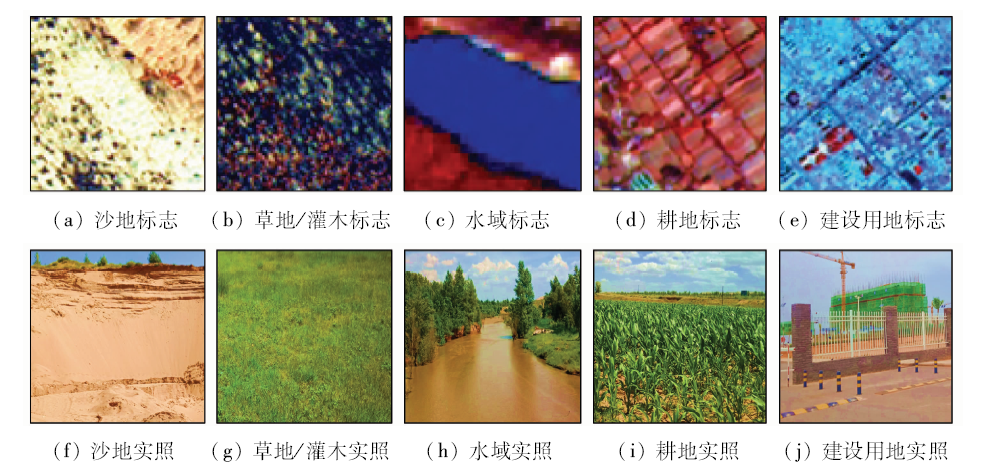
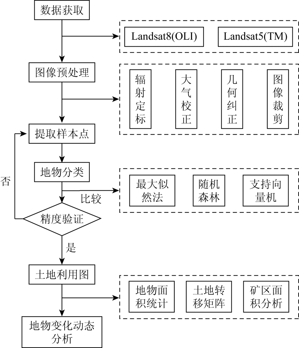
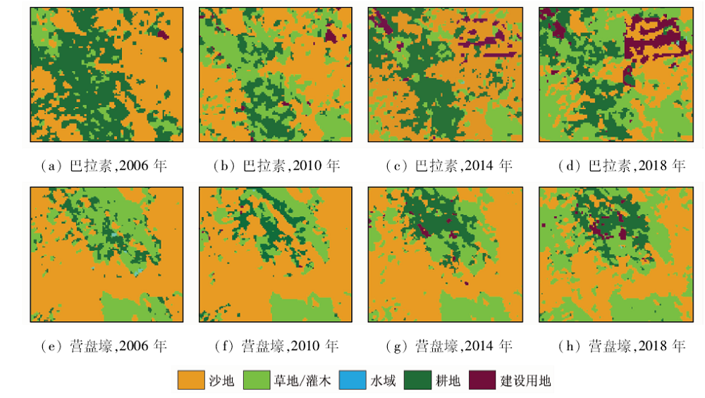
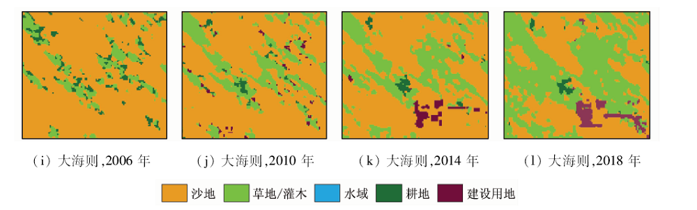
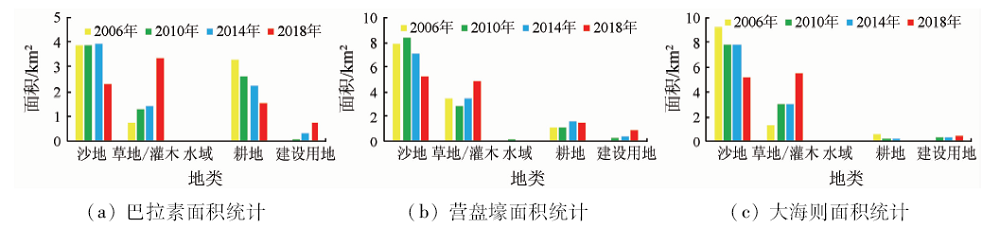
Abstract To tackle the problem whether mining will cause great changes in the types of surface features and environmental deterioration, the authors used Landsat (TM,OLI) images to classify the land in 2006, 2010, 2014 and 2018 in Hailiutu watershed, and revealed the temporal and spatial characteristics of land use changes in three stages (one stage every four years) from 2006 to 2018. Screening and comparing the classification methods MLE, SVM, RF and applying the statistical methods of features change and transfer matrix show that the accuracy of land classification map obtained by RF is better than that of the other classification methods, and the quantitative interpretation of land classification analysis was carried out for many years. In the three stages, the transformation of sandy land and grassland/shrub was frequent, the total area of sandy land decreased by 16.83%, the grassland/shrub increased by 12.68%, and the construction land increased steadily year by year. By 2018, the development of the mining area had not caused great damage to the ecological environment, and the change of the geological structure of the mine was consistent with the trend of the geological structure of Hailiutu basin.
|
| Keywords
remote sensing
transfer matrix
mining disturbance
land use
|
|
|
|
Corresponding Authors:
ZHANG Shengwei
E-mail: Gao19950723@126.com;zsw@imau.edu.cn
|
|
Issue Date: 09 October 2020
|
|
|
| [1] |
Lawler J J, Lewis D J, Nelson E, et al. Projected land-use change impacts on ecosystem services in the United States[J]. Proceedings of the National Academy of Sciences, 2014,111(20):7492-7497.
doi: 10.1073/pnas.1405557111
url: http://www.pnas.org/cgi/doi/10.1073/pnas.1405557111
|
| [2] |
Wulder M A, White J C, Goward S N, et al. Landsat continuity:Issues and opportunities for land cover monitoring[J]. Remote Sensing of Environment, 2008,112(3):955-969.
doi: 10.1016/j.rse.2007.07.004
url: https://linkinghub.elsevier.com/retrieve/pii/S0034425707003331
|
| [3] |
Mooney H A, Duraiappah A, Larigauderie A. Evolution of natural and social science interactions in global change research programs[J]. Proceedings of the National Academy of Sciences, 2013,110(1):3665-3672.
doi: 10.1073/pnas.1107484110
url: http://www.pnas.org/cgi/doi/10.1073/pnas.1107484110
|
| [4] |
Zhou R, Lin M, Gong J, et al. Spatiotemporal heterogeneity and influencing mechanism of ecosystem services in the Pearl River Delta from the perspective of LUCC[J]. Journal of Geographical Sciences, 2019,29(5):831-845.
doi: 10.1007/s11442-019-1631-0
url: http://www.geogsci.com/EN/abstract/abstract42854.shtml
|
| [5] |
石玉琼, 李团胜, 史晓惠, 等. 榆林地区榆林地区景观生态敏感性时空特征[J]. 国土资源遥感, 2017,29(2):167-172.doi: 10.6046/gtzyyg.2017.02.24.
|
| [5] |
Shi Y Q, Li T S, Shi X H, et al. Spatial-temporal characteristics of landscape ecological sensitivity in Yulin area[J]. Remote Sensing for Land and Resources, 2017,29(2):167-172.doi: 10.6046/gtzyyg.2017.02.24.
|
| [6] |
Wang X, Tan K, Xu K, et al. Quantitative evaluation of the eco-environment in a coalfield based on multi-temporal remote sensing imagery:A case study of Yuxian,China[J]. International Journal of Environmental Research and Public Health, 2019,16(3).
doi: 10.3390/ijerph16030515
pmid: 30759776
url: https://www.ncbi.nlm.nih.gov/pubmed/30759776
|
| [7] |
刁娇娇, 龚鑫烨, 李明诗. 利用综合变化检测方法进行土地覆盖变化制图[J]. 国土资源遥感, 2018,30(1):157-165.doi: 10.6046/gtzyyg.2018.01.22.
|
| [7] |
Diao J J, Gong X Y, Li M S. A comprehensive change detection method for updating land cover data base[J]. Remote Sensing for land and Resources, 2018,30(1):157-165.doi: 10.6046/gtzyyg.2018.01.22.
|
| [8] |
宁佳, 刘纪远, 匡文慧, 等. 中国2010—2015年土地利用变化的时空格局与新特征[J]. 地理学报, 2018,73(5):789-802.
doi: 10.11821/dlxb201805001
url: http://www.geog.com.cn/CN/abstract/abstract40219.shtml
|
| [8] |
Ning J, Liu J Y, Kuang W H, et al, Spatiotemporal patterns and characteristics of land-use change in China during 2010—2015[J].Journal of Geographical Sciences,2018(5):789-802.
|
| [9] |
李秀彬. 全球环境变化研究的核心领域——土地利用/土地覆被变化的国际研究动向[J].地理学报, 1996(6):553-558.
doi: 10.11821/xb199606009
url: http://www.geog.com.cn/CN/abstract/abstract21037.shtml
|
| [9] |
Li X B. A review of the international researches on land use/land cover change[J].Acta Geographica Sinica 1996(6):553-558.
doi: 10.11821/xb199606009
url: http://www.geog.com.cn/CN/abstract/abstract21037.shtml
|
| [10] |
庄逐舟, 刘嘉勋, 蔡凌雁, 等. 黄土高原土地利用/覆被变化研究进展[J]. 水土保持, 2016,4(3):29-39.
|
| [10] |
Zhuang Z Z, Liu J X, Cai L Y, et al. Research progress of land use/land cover change(LUCC) in the Loess Plateau[J]. Open Journal of Soil and Water Conservation, 2016,4(3):29-39.
doi: 10.12677/OJSWC.2016.43005
url: http://www.HansPub.org/journal/PaperDownload.aspx?DOI=10.12677/OJSWC.2016.43005
|
| [11] |
牛潞珍, 石英. 土地利用/覆盖变化研究进展综述[J].东南大学学报(哲学社会科学版), 2014(s1):25-26.
|
| [11] |
Liu L Z, Shi Y. A review of research progress on land use/cover change[J].Journal of Southeast University(Philosophy and Science Edition) 2014(s1):25-26.
|
| [12] |
刘纪远, 张增祥, 徐新良, 等. 21世纪初中国土地利用变化的空间格局与驱动力分析[J]. 地理学报, 2009,64(12):1411-1420.
doi: 10.11821/xb200912001
url: http://www.geog.com.cn/CN/abstract/abstract18267.shtml
|
| [12] |
Liu J Y, Zhang Z X, Xu X L, et al. Spatial patterns and driving forces of land use change in China in the early 21st century[J]. Acta Geographica Sinica, 2009,64(12):1411-1420.
doi: 10.11821/xb200912001
url: http://www.geog.com.cn/CN/abstract/abstract18267.shtml
|
| [13] |
顿耀龙, 王军, 白中科, 等. 基于灰色模型预测的矿区生态系统服务价值变化研究——以山西省平朔露天矿区为例[J]. 资源科学, 2015,37(3):494-502.
url: http://159.226.115.21/zykx/CN/abstract/abstract4120.shtml
|
| [13] |
Dun Y L, Wang J, Bai Z K, et al. Changes in Pingshuo opencast mining area ecosystem service values based on grey prediction modeling[J]. Resources Science, 2015,37(3):494-502.
url: http://159.226.115.21/zykx/CN/abstract/abstract4120.shtml
|
| [14] |
Fei Z, Ayinuer Y, Dong F W. Ecological risk assessment due to land use/cover changes (LUCC) in Jinghe County,Xinjiang,China from 1990 to 2014 based on landscape patterns and spatial statistics[J]. Environmental Earth Sciences, 2018,77(13):491.
doi: 10.1007/s12665-018-7676-z
url: https://doi.org/10.1007/s12665-018-7676-z
|
| [15] |
Jiang J, Tian G. Analysis of the impact of land use/land cover change on land surface temperature with remote sensing[J]. Procedia Environmental Sciences, 2010,(2):0-575.
|
| [16] |
张军峰, 孟凡浩. 新疆孔雀河流域人工绿洲近40年土地利用/覆被变化[J]. 中国沙漠, 2018,38(3):223-231.
|
| [16] |
Zhang J F, Meng F H. LUCC analysis of the upstream of the Kongqi River,Xinjiang,China[J]. Journal of Desert Research, 2018,38(3):223-231.
|
| [17] |
李晶, 申莹莹, 焦利鹏, 等. 基于Landsat TM/OLI影像的兖州煤田水域面积动态监测[J]. 农业工程学报, 2017,33(18):243-250.
url: http://www.tcsae.org/nygcxb/ch/reader/view_abstract.aspx?file_no=20171832&flag=1
|
| [17] |
Li J, Shen Y Y, Jiao L P, et al. Dynamic monitoring of water areas in Yanzhou coalfield based on Landsat TM/OLI images[J]. Transactions of the Chinese Society of Agricultural Engineering, 2017,33(18):243-250.
url: http://www.tcsae.org/nygcxb/ch/reader/view_abstract.aspx?file_no=20171832&flag=1
|
| [18] |
马慧娟, 高小红, 谷晓天. 随机森林方法支持的复杂地形区土地利用/土地覆被分类研究[J]. 地球信息科学学报, 2019,21(3):359-371.
doi: 10.12082/dpxxkx.2019.180346
url: http://www.dqxxkx.cn/CN/abstract/abstract42948.shtml
|
| [18] |
Ma H J, Gao X H, Gu X T. Random forest classification of Landsat8 imagery for the complex terrain area based on the combination of spectral,topographic and texture information[J]. Journal of Geo-Information Science, 2019,21(3):359-371.
|
| [19] |
张康, 黑保琴, 李盛阳, 等. 基于CNN模型的遥感图像复杂场景分类[J]. 国土资源遥感, 2018,30(4):49-55.doi: 10.6046/gtzyyg.2018.04.08.
|
| [19] |
Zhang K, Hei B Q, Li S Y, et al. Complex scene classification of remote sensing images based on CNN[J]. Remote Sensing for land and Resources, 2018,30(4):49-55.doi: 10.6046/gtzyyg.2018.04.08.
|
| [20] |
Oliphant A, Thenkabail P, Teluguntla P, et al. Mapping cropland extent of Southeast and Northeast Asia using multi-year time-series Landsat 30-m data using a random forest classifier on the Google Earth Engine Cloud[J]. International Journal of Applied Earth Observations and Geoinformation, 2019,81(9):110-124.
doi: 10.1016/j.jag.2018.11.014
url: https://linkinghub.elsevier.com/retrieve/pii/S0303243418307414
|
| [21] |
苏腾飞, 刘全明, 苏秀川. 基于多种植被指数时间序列与机器学习的作物遥感分类研究[J]. 江苏农业科学, 2017,45(16):219-224.
|
| [21] |
Su T F, Liu Q M, Su X C. Crop remote sensing classification based on multi vegetation index time series and machine learning[J]. Jiangsu Agricultural Sciences, 2017,45(16):219-224.
|
| [22] |
Breiman L. Random forests[J]. Machine Learning, 2001,45(1):5-32.
doi: 10.1023/A:1010933404324
url: http://www.springerlink.com/content/u0p06167n6173512/
|
| [23] |
樊利恒, 吕俊伟, 于振涛, 等. 基于改进最大似然方法的多光谱遥感图像分类方法[J]. 电光与控制, 2014,21(10):52-74.
|
| [23] |
Fan L H, Lyu J W, Yu Z T, et al. Multispectral remote sensing image classification method based on improved maximum likelihood method[J]. Electronics Optics & Control, 2014,21(10):52-74.
|
| [24] |
徐凯健, 田庆久, 杨闫君, 等. 遥感土地覆被分类的空间尺度响应研究[J]. 地球信息科学学报, 2018,20(2):246-253.
doi: 10.12082/dqxxkx.2018.170360
url: http://www.dqxxkx.cn/CN/abstract/abstract40033.shtml
|
| [24] |
Xu K J, Tian Q J, Yang Y J, et al. Response of spatial scale for land cover classification of remote sensing[J]. Journal of Geo-Information Science, 2018,20(2):246-253.
|
| [25] |
Mellor A, Haywood A, Stone C, et al. The performance of random forests in an operational setting for large area sclerophyll forest classification[J]. Remote Sensing, 2013,5(6):2838-2856.
doi: 10.3390/rs5062838
url: http://www.mdpi.com/2072-4292/5/6/2838
|
| [26] |
陈伟民, 张凌, 宋冬梅, 等. 基于AdaBoost改进随机森林的高光谱图像地物分类方法研究[J]. 遥感技术与应用, 2018,33(4):612-620.
|
| [26] |
Chen W M, Zhang L, Song D M, et al. Research on hyperspectral imagery land cover classification method based on Adaboost improved random forest[J]. Remote Sensing Technology and Application, 2018,33(4):612-620.
|
| [27] |
Son N T, Chen C F, Chen C R, et al. Assessment of Sentinel-1A data for rice crop classification using random forests and support vector machines[J]. Geocarto International, 2017: 1-15.
|
| [28] |
田绍鸿, 张显峰. 采用随机森林法的天绘数据干旱区城市土地覆盖分类[J]. 国土资源遥感, 2016,28(1):43-49.doi: 10.6046/gtzyyg.2016.01.07.
doi: 10.6046/gtzyyg.2016.01.07
url: http://www.gtzyyg.com/CN/abstract/abstract1946.shtml
|
| [28] |
Tian S H, Zhang X F. Random forest classification of land cover information of urban areas in arid regions based on TH-1 data[J]. Remote Sensing for Land and Resources, 2016,28(1):43-49.doi: 10.6046/gtzyyg.2016.01.07.
|
| [29] |
黄双燕, 杨辽, 陈曦, 等. 机器学习法的干旱区典型农作物分类[J]. 光谱学与光谱分析, 2018,38(10):3169-3176.
|
| [29] |
Huang S Y, Yang L, Chen X, et al. Study of typical arid crops classification based on machine learning[J]. Spectroscopy and Spectral Analysis, 2018,38(10):3169-3176.
|
| [30] |
桑潇, 国巧真, 潘应阳, 等. 基于TM和OLI数据山西省潞城市土地利用动态变化分析与预测[J]. 国土资源遥感, 2018,30(2):125-131.doi: 10.6046/gtzyyg.2018.02.17.
|
| [30] |
Sang X, Guo Q Z, Pan Y Y, et al. Research on land use dynamic change and prediction in Lucheng City of Shanxi Province based on TM and OLI[J]. Remote Sensing for Land and Resources, 2018,30(2):125-131.doi: 10.6046/gtzyyg.2018.02.17.
|
|
Viewed |
|
|
|
Full text
|
|
|
|
|
Abstract
|
|
|
|
|
Cited |
|
|
|
|
| |
Shared |
|
|
|
|
| |
Discussed |
|
|
|
|
 2020,
Vol. 32
2020,
Vol. 32