|
|
 |
|

|
|
|
Application of airborne LiDAR in the estimation of the mean height of mangrove stand |
DENG Jingwen1( ), TIAN Yichao1,2(), ZHANG Qiang1, TAO Jin1,3, ZHANG Yali1, HUANG Shengguang3 ), TIAN Yichao1,2(), ZHANG Qiang1, TAO Jin1,3, ZHANG Yali1, HUANG Shengguang3 |
1. Collage of Resources and Environment, Beibu Gulf University, Qinzhou 535000, China
2. Guangxi Key Laboratory of Marine Disaster in the Beibu Gulf, Beibu Gulf University, Qinzhou 535000, China
3. Key Laboratory of Marine Geographic Information Resources Development and Utilization, Beibu Gulf University, Qinzhou 535000, China |
|
|
|
|
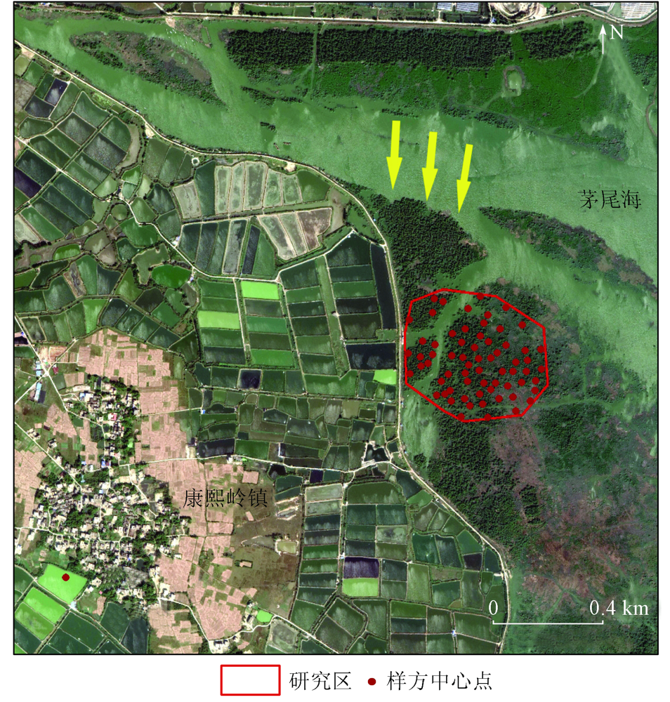
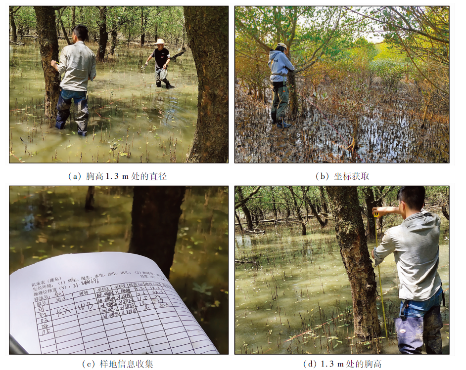
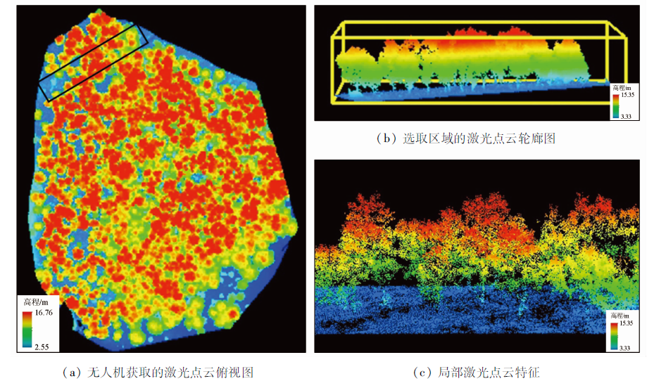
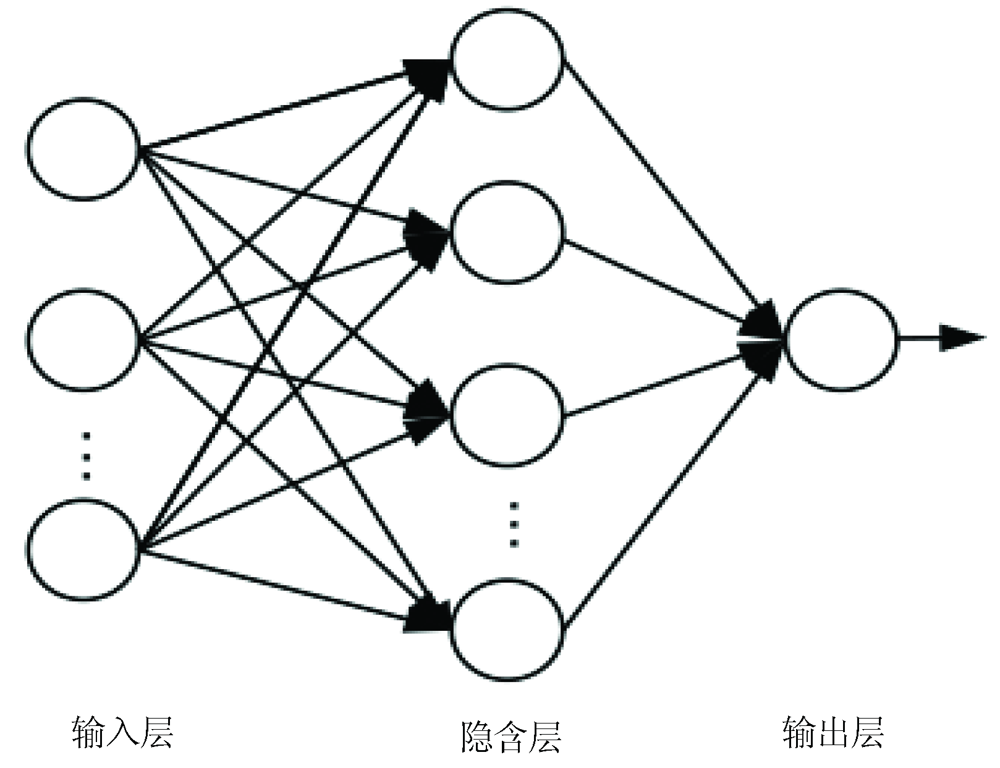
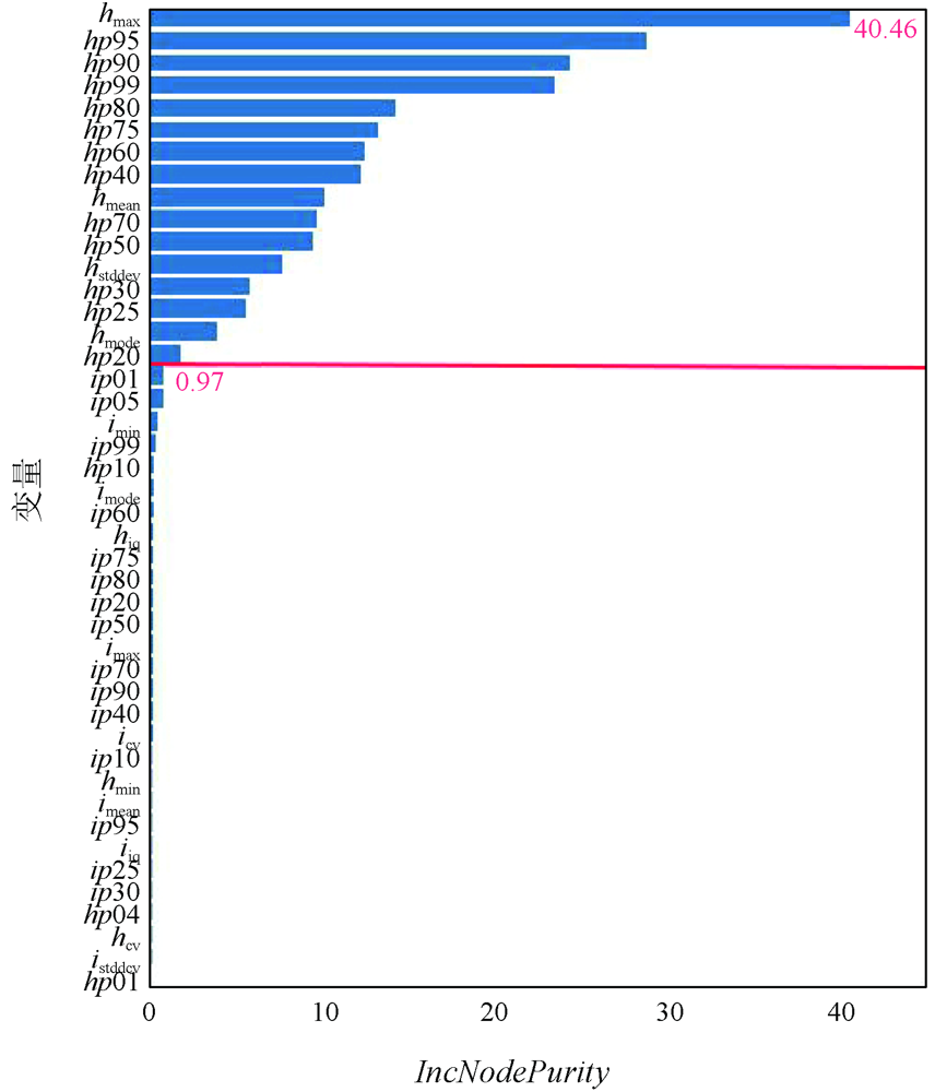
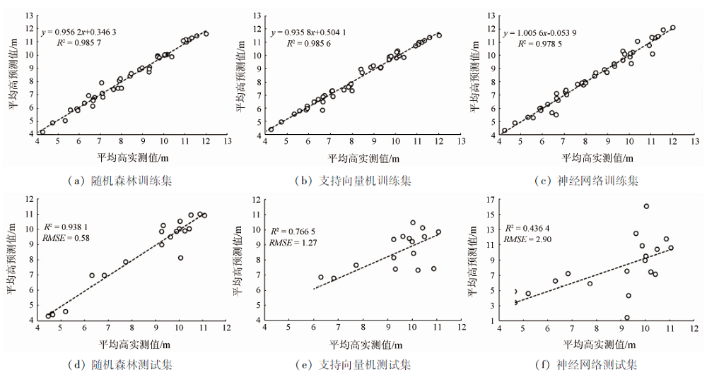
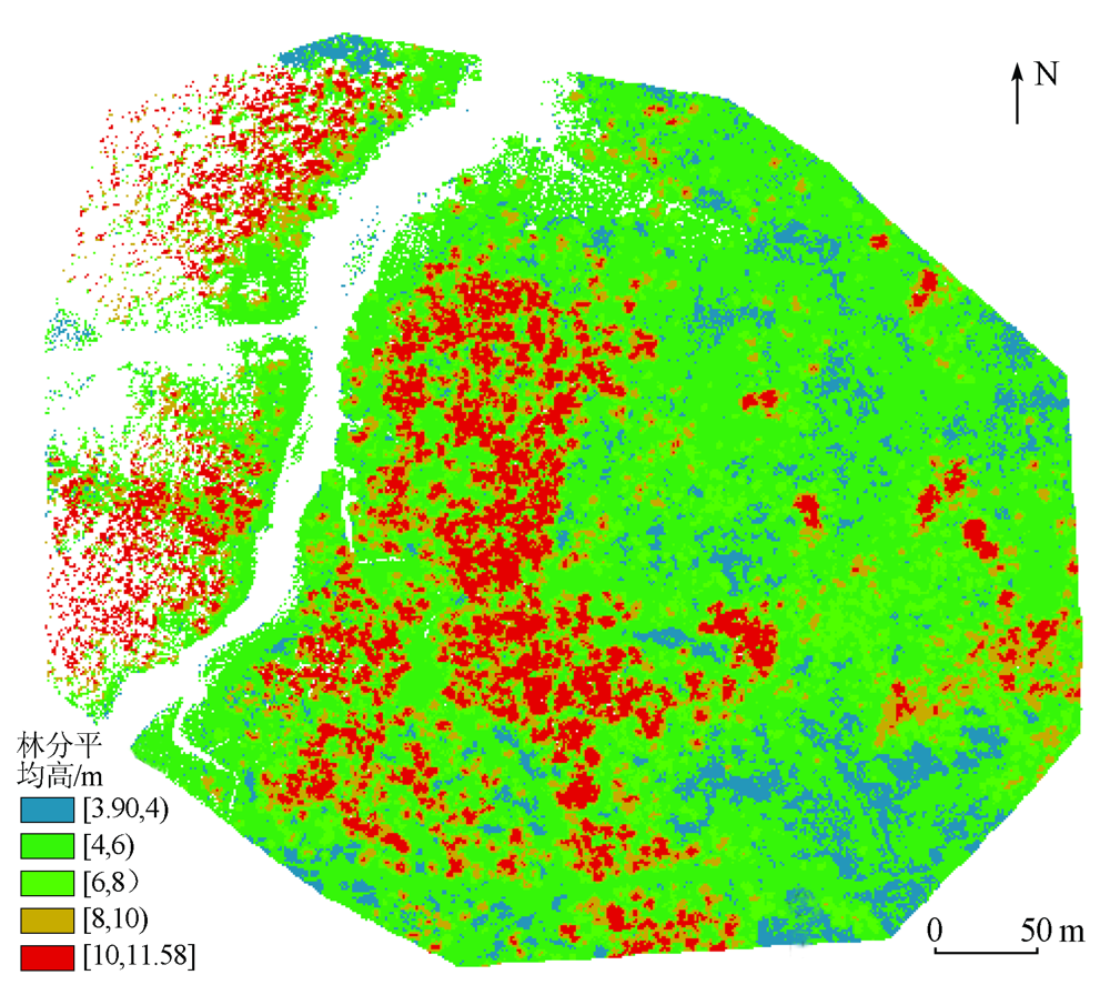
Abstract This study constructed a stand mean height inversion model based on LiDAR data, aiming to provide dynamic monitoring of the growth of Sonneratia apetala. Taking the mangrove wetland of Sonneratia apetala in the Maowei Sea of Beibu Gulf as the study object and based on the height and intensity parameters extracted using airborne LiDAR data, this study compared three models, namely random forest, support vector machine, and neural network, based on the coefficient of determination (R2), root mean square error (RMSE), Akachi information criterion (AIC), and Bayesian information criterion (BIC) and then estimated the mean height and spatial distribution of Mangrove in the study area using the optimal model. The results are as follows. The stand mean height of Sonneratia apetala in the study area is 3.90~11.58 m, and Sonneratia apetala with a higher tree height and a larger diameter at breast height is mainly distributed near the tidal trench and the middle part of the study area. In the estimation of the stand mean height of Sonneratia apetala, the maximum percentile height (hmax) had the highest contribution rate, followed by 75%~99% percentile height. The random forest regression model yielded the highest precision (R2=0.938 1,RMSE=0.58 m,AIC=80.50, and BIC=49.05), followed by the support vector machine model (R2 = 0.766 5 and RMSE = 1.27 m in the test stage), and the neural network regression model yielded the worst fitting effects. Overall, the random forest model is the optimal model for the inversion of the stand mean height of Sonneratia apetala in the study area.
|
| Keywords
Sonneratia apetala
support vector machine
neural network
random forest
stand mean height
|
|
|
|
Corresponding Authors:
TIAN Yichao
E-mail: 1687606800@qq.com;tianyichao1314@yeah.net
|
|
Issue Date: 21 September 2022
|
|
|
| [1] |
庞勇, 李增元, 陈尔学, 等. 激光雷达技术及其在林业上的应用[J]. 林业科学, 2005(3):129-136.
|
| [1] |
Pang Y, Li Z Y, Chen E X, et al. LiDAR remote sensing technology and its application in forestry[J]. Scientia Silvae Sinicae, 2005(3):129-136.
|
| [2] |
Næsset E, Økland T. Estimating tree height and tree crown properties using airborne scanning laser in a boreal nature reserve[J]. Remote Sensing of Environment, 2002, 79(1):105-115.
doi: 10.1016/S0034-4257(01)00243-7
url: https://linkinghub.elsevier.com/retrieve/pii/S0034425701002437
|
| [3] |
Andersen H E, Mcgaughey R J, Reutebuch S E. Estimating forest canopy fuel parameters using LiDAR data[J]. Remote Sensing of Environment, 2005, 94(4):441-449.
doi: 10.1016/j.rse.2004.10.013
url: https://linkinghub.elsevier.com/retrieve/pii/S0034425704003438
|
| [4] |
焦义涛, 邢艳秋, 霍达, 等. 基于机载LiDAR点云估测林分的平均树高[J]. 西北林学院学报, 2015, 30(3):170-174.
|
| [4] |
Jiao Y T, Xing Y Q, Huo D, et al. Study on mean canopy height estimation from airborne LiDAR point cloud date[J]. Journal of Northwest Forestry University, 2015, 30(3):170-174.
|
| [5] |
洪奕丰, 张守攻, 陈伟, 等. 基于机载激光雷达的落叶松组分生物量反演[J]. 林业科学研究, 2019, 32(5):83-90.
|
| [5] |
Hong Y F, Zhang S G, Chen W, et al. Inversion of biomass components for Larix olgensis plantation using airborne LiDAR[J]. Forest Research, 2019, 32(5):83-90.
|
| [6] |
Li M, Im J, Quackenbush L J, et al. Forest biomass and carbon stock quantification using airborne LiDAR data:A case study over Huntington Wildlife Forest in the Adirondack Park[J]. IEEE Journal of Selected Topics in Applied Earth Observations and Remote Sensing, 2017, 7(7):3143-3156.
doi: 10.1109/JSTARS.2014.2304642
url: https://ieeexplore.ieee.org/document/6748911/
|
| [7] |
Monnet J M, Chanussot J, Berger F. Support vector regression for the estimation of forest stand parameters using airborne laser scanning[J]. IEEE Geoscience and Remote Sensing Letters, 2011, 8(3):580-584.
doi: 10.1109/LGRS.2010.2094179
url: http://ieeexplore.ieee.org/document/5682006/
|
| [8] |
鲁林, 周小成, 余治忠, 等. 随机森林算法在机载LiDAR数据林分平均树高估算中的应用研究[J]. 地球信息科学学报, 2016, 18(8):1133-1140.
doi: 10.3724/SP.J.1047.2016.01133
|
| [8] |
Lu L, Zhou X C, Yu Z Z, et al. Plot-level forest height inversion using airborne LiDAR data based on the random forest[J]. Journal of Geo-Information Science, 2016, 18(8):1133-1140.
|
| [9] |
赵勋, 岳彩荣, 李春干, 等. 基于机载LiDAR数据估测林分平均高[J]. 林业科学研究, 2020, 33(4):59-66.
|
| [9] |
Zhao X, Yue C R, Li C G, et al. Estimation of forest stand mean height based on airborne LiDAR point cloud data[J]. Forest Research, 2020, 33(4):59-66.
|
| [10] |
王德智. 结合UAV-LiDAR和卫星遥感数据的红树林多尺度观测方法研究[D]. 武汉: 中国地质大学(武汉), 2020.
|
| [10] |
Wang D Z. Integration of UAV-LiDAR data and satellite imagery for multi-scale mangrove observation[D]. Wuhan: China University of Geosciences(Wuhan), 2020.
|
| [11] |
Tian Y C, Huang H, Zhang G Q, et al. Aboveground mangrove biomass estimation in Beibu Gulf using machine learning and UAV remote sensing[J]. Science of the Total Environment, 2021, 781:146816-146834.
doi: 10.1016/j.scitotenv.2021.146816
url: https://linkinghub.elsevier.com/retrieve/pii/S0048969721018842
|
| [12] |
廖宝文, 郑松发, 陈玉军, 等. 外来红树植物无瓣海桑生物学特性与生态环境适应性分析[J]. 生态学杂志, 2004(1):10-15.
|
| [12] |
Liao B W, Zheng S F, Chen Y J, et al. Biological characteristics and ecological adaptability for non-indigenous mangrove species Sonneratia apetala[J]. Chinese Journal of Ecology, 2004(1):10-15.
|
| [13] |
邓必玉. 广西钦州沿海无瓣海桑入侵性初探[J]. 湖北林业科技, 2020, 49(5):46-52.
|
| [13] |
Deng B Y. A preliminary exploration on the eological invasion of Sonneratia apetala in Qinzhou area of Guangxi[J]. Hubei Forestry Science and Technology, 2020, 49(5):46-52.
|
| [14] |
田义超, 黄远林, 张强, 等. 北部湾典型海岛生态系统服务价值空间异质性对比研究[J]. 海洋科学, 2019, 43(2):60-68.
|
| [14] |
Tian Y C, Huang Y L Zhang Q, et al. A comparative study of spatial heterogeneity of ecosystem service value in typical islands in Beibu Gulf[J]. Marine Sciences, 2019, 43(2):60-68.
|
| [15] |
周生祥. 林分平均树高的求算与分析[J]. 华东森林经理, 1989(3):37-45.
|
| [15] |
Zhou S X. Calculation and analysis of mean height of tree stand[J]. East China Forest Management, 1989(3):37-45.
|
| [16] |
Baltsavias E P. Airborne laser scanning:Basic relations and formulas[J]. ISPRS Journal of Photogrammetry and Remote Sensing, 1999, 54(2-3):199-214.
doi: 10.1016/S0924-2716(99)00015-5
url: https://linkinghub.elsevier.com/retrieve/pii/S0924271699000155
|
| [17] |
邵为真, 赵富燕, 梁周雁. 基于不规则三角网的渐进加密滤波算法研究[J]. 北京测绘, 2016(6):17-21.
|
| [17] |
Shao W Z, Zhao F Y, Liang Z Y. The research of improved progressive triangulated irregular network densification filtering algorithm[J]. Beijing Surveying and Mapping, 2016(6):17-21.
|
| [18] |
Breiman L. Random forest[J]. Machine Learning, 2001, 45:5-32.
doi: 10.1023/A:1010933404324
url: http://link.springer.com/10.1023/A:1010933404324
|
| [19] |
Gholami R, Fakhari N. Support vector machine:Principles,parameters,and applications[J]. Handbook of Neural Computation, 2017, 27:515-535.
|
| [20] |
欧强新. 基于机器学习的吉林天然针阔混交林生长建模[D]. 北京: 中国林业科学研究院, 2019.
|
| [20] |
Ou Q X. Modeling stand growth of natural conifer and broadleaf mixed forests in Jilin Province based on machine learning[D]. Beijing: Chinese Academy of Forestry, 2019.
|
| [21] |
Akaike H T. A new look at the statistical model identification[J]. IEEE Transactions on Automatic Control, 1974, 19(6):716-723.
doi: 10.1109/TAC.1974.1100705
url: http://ieeexplore.ieee.org/document/1100705/
|
| [22] |
Schwarz G E. Estimating the dimension of a model[J]. The Annals of Statistics, 1978, 6(2):461-464.
|
| [23] |
Vrieze, Scott I. Model selection and psychological theory:A discussion of the differences between the Akaike information criterion (AIC) and the Bayesian information criterion (BIC)[J]. Psychological methods, 2012, 17(2):228-243.
doi: 10.1037/a0027127
pmid: 22309957
|
| [24] |
张晓君, 管伟, 廖宝文, 等. 珠海人工红树林与天然红树林群落特征比较研究[J]. 生态科学, 2014, 33(2):321-326.
|
| [24] |
Zhang X J, Guan W, Liao B W, et al. Comparison on the community characteristics between artificial and natural mangroves in Zhuhai City[J]. Ecological Science, 2014, 33(2):321-326.
|
| [25] |
黄晓敏, 卢昌义. 厦门海湾典型无瓣海桑人工种群特征和幼苗更新扩散现状研究[J]. 生态科学, 2018, 37(5):1-6.
|
| [25] |
Huang X M, Lu C Y. Studies on the characteristics of artificial population of Sonneratia apetala and the current recruitment and dispersal of the seedlings in Xiamen Bay[J]. Ecological Science, 2018, 37(5):1-6.
|
| [26] |
吴瑞, 陈丹丹, 王道儒, 等. 海南省东寨港红树林资源现状调查分析[J]. 热带农业科学, 2016, 36(9):62-71.
|
| [26] |
Wu R, Chen D D, Wang D R, et al. Survey of mangrove resources in Dongzhai Harbour of Hainan Province[J]. Chinese Journal of Tropical Agriculture, 2016, 36(9):62-71.
|
| [27] |
郑俊鸣, 舒志君, 方笑, 等. 红树林造林修复技术探讨[J]. 防护林科技, 2016(1):99-103.
|
| [27] |
Zheng J M, Shu Z J, Fang X, et al. Discussion on techniques of mangrove afforestation and rehabilitation[J]. Protection Forest Science and Technology, 2016(1):99-103.
|
| [28] |
廖宝文. 中国红树林恢复与重建技术[M]. 北京: 科学出版社, 2010:20-44.
|
| [28] |
Liao B W. Restoration and teconstruction techniques of mangrove forests in China[M]. Beijing: Science Press, 2010:20-44.
|
| [29] |
Lu D S, Chen Q, Wang G X, et al. Aboveground forest biomass estimation with Landsat and LiDAR data and uncertainty analysis of the estimates[J]. International Journal of Forestry Research, 2012(2):436537-436553.
|
| [30] |
Brice M, Michael A W, Geordie W H, et al. Forest inventory stand height estimates from very high spatial resolution satellite imagery calibrated with LiDAR plots[J]. International Journal of Remote Sensing, 2013, 34(12):4406-4424.
doi: 10.1080/01431161.2013.779041
url: https://www.tandfonline.com/doi/full/10.1080/01431161.2013.779041
|
| [31] |
Pourrahmati M R, Baghdadi N, Darvishsefat A A, et al. Mapping Lorey’s height over Hyrcanian forests of Iran using synergy of ICESat/GLAS and optical images[J]. European Journal of Remote Sensing, 2018, 51(1):100-115.
doi: 10.1080/22797254.2017.1405717
url: https://www.tandfonline.com/doi/full/10.1080/22797254.2017.1405717
|
| [32] |
Waske B, Benediktsson J A, Árnason, et al. Mapping of hyperspectral AVIRIS data using machine-learning algorithms[J]. Canadian Journal of Remote Sensing, 2009, 35(1):106-116.
|
|
Viewed |
|
|
|
Full text
|
|
|
|
|
Abstract
|
|
|
|
|
Cited |
|
|
|
|
| |
Shared |
|
|
|
|
| |
Discussed |
|
|
|
|
 2022,
Vol. 34
2022,
Vol. 34