|
|
 |
|

|
|
|
A study on the characteristics and model of drought in Xinjiang based on multi-source data |
QIN Dahui1( ), YANG Ling1, CHEN Lunchao1, DUAN Yunfei1, JIA Hongliang1, LI Zhenpei1, MA Jianqin2 ), YANG Ling1, CHEN Lunchao1, DUAN Yunfei1, JIA Hongliang1, LI Zhenpei1, MA Jianqin2 |
1. School of Civil Engineering and Geomatics, Southwest Petroleum University, Chengdu 610500, China
2. School of Water Conservancy, North China University of Water Conservancy and Hydroelectric Power, Zhengzhou 450046, China |
|
|
|
|
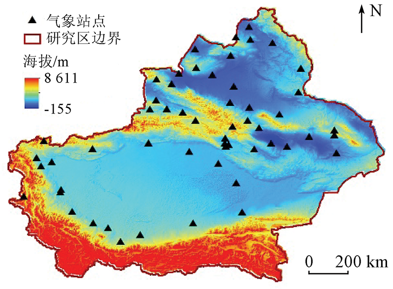
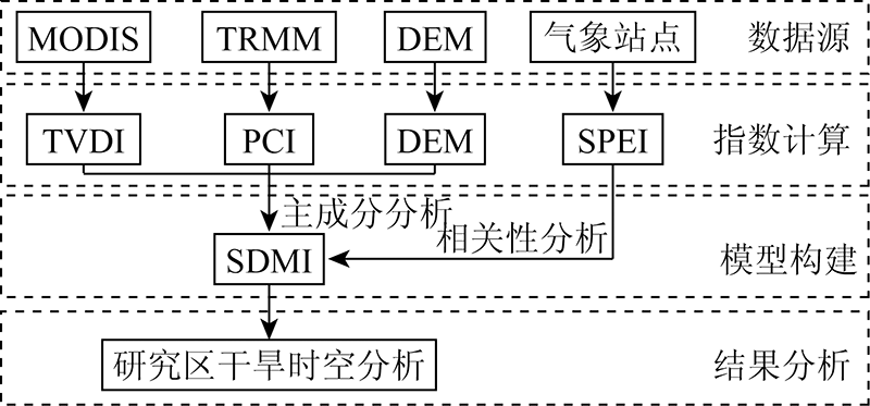
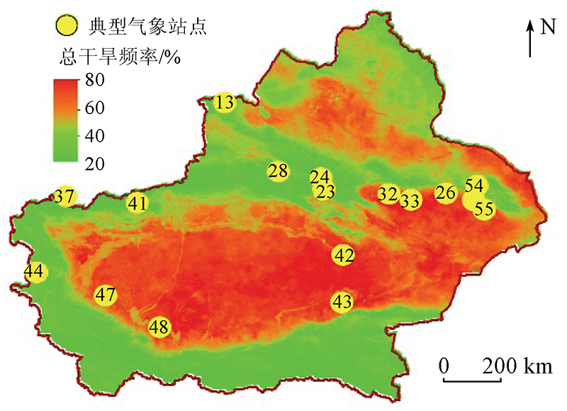
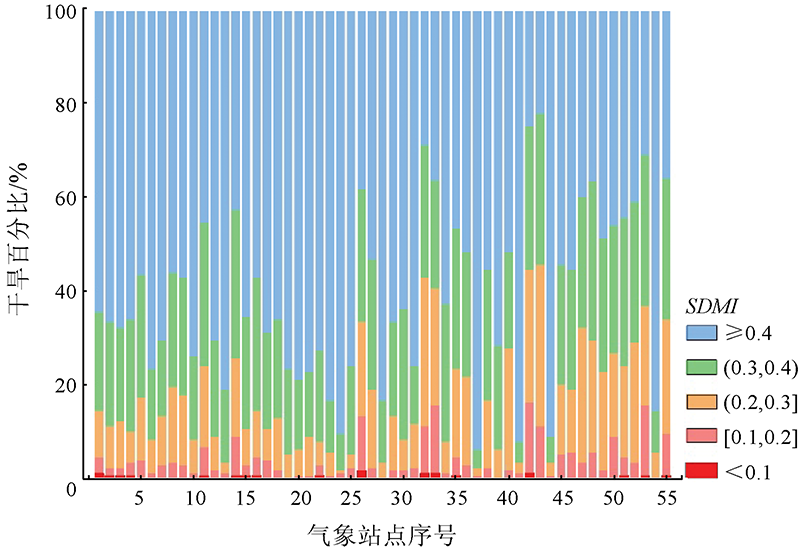
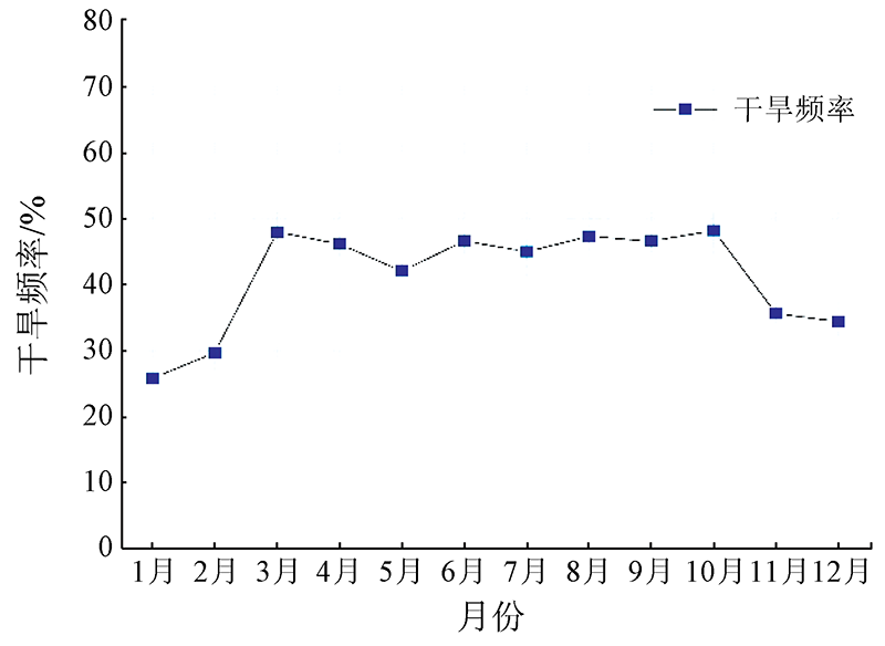
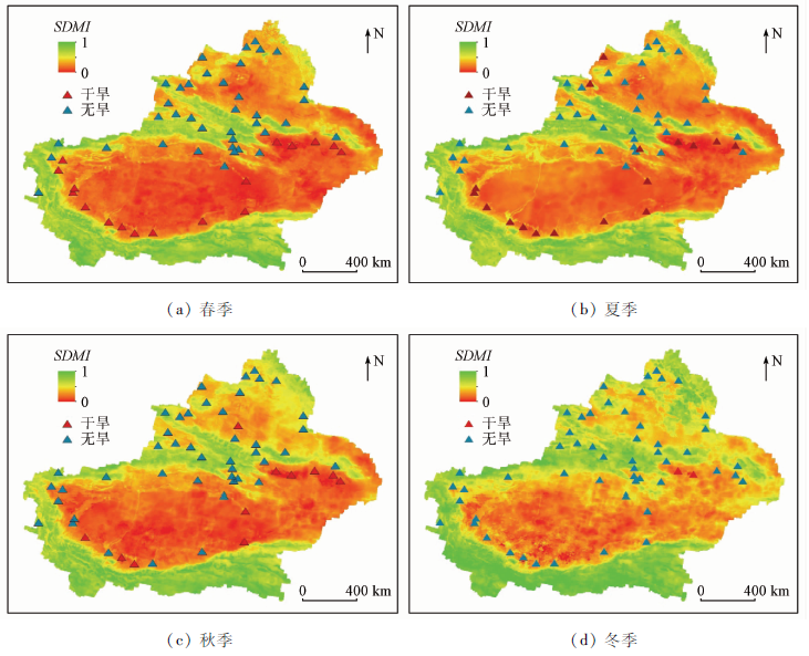
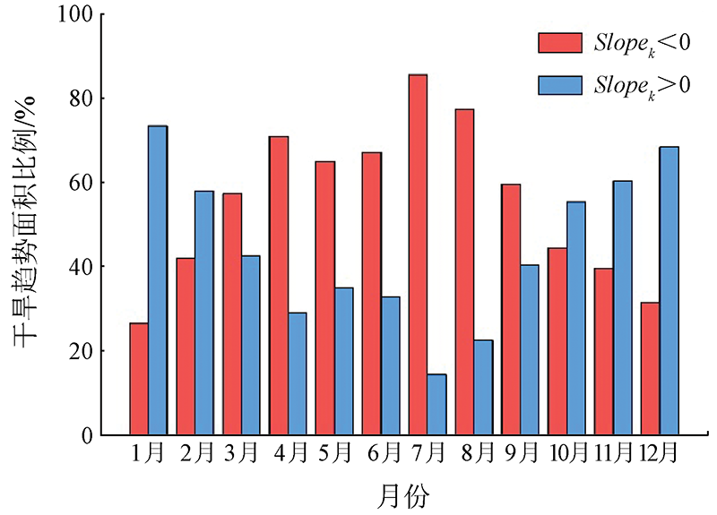
Abstract An improved and comprehensive drought monitoring model was developed in this study. Given multi-genetic types such as the interaction of atmospheric precipitation, vegetation growth, and elevation, multiple data sources were selected for the model, including EOS-MODIS data, TRMM precipitation data, and the region SRTM-DEM(digital elevation model) data from 2001 to 2019 in Xinjiang. The parameters including precipitation concentration index (PCI), temperature and vegetation drought index (TVDI), and DEM were calculated, and the principal component analysis (PCA) method was employed to establish the model. Then, the model was used to analyze the spatio-temporal characteristics of drought in the study area. The analytical results show that the annual occurrence frequency of drought in the study area from 2001 to 2019 was high in the middle part and low in the surrounding areas. In addition, drought struck 47.7% of the study area, and the occurrence frequency of drought reached 60% in 32.3% of the drought regions. Meanwhile, drought was concentrated in the Tarim and Turpan basins. The changing trends of drought in the study area differed greatly. For the linear regression slope of drought from March and September, the absolute values of the positive slope were far greater than those of the negative slope. Based on this, it can be predicted that the drought in the study area mainly included spring and summer droughts in 2020.
|
| Keywords
drought monitoring
multi-source data
principal component analysis
spatio-temporal evolution
trend analysis
|
|
|
|
Issue Date: 14 March 2022
|
|
|
| [1] |
Abuzar M K, Shafiq M, Mahmood S A, et al. Drought risk assessment in the Khushab region of Pakistan using satellite remote sensing and geospatial methods[J]. International Journal of Economic and Environment Geology, 2019, 10(1):48-56.
doi: 10.46660/ijeeg.Vol10.Iss1.2019.217
url: https://www.econ-environ-geol.org/index.php/ojs/article/view/217
|
| [2] |
沈润平, 郭佳, 张婧娴, 等. 基于随机森林的遥感干旱监测模型的构建[J]. 地球信息科学学报, 2017, 19(1):125-133.
doi: 10.3724/SP.J.1047.2017.00125
|
| [2] |
Shen R P, Guo J, Zhang J X, et al. Construction of a drought monitoring model using the random forest based remote sensing[J]. Journal of Geo-Information Science, 2017, 19(1):125-133.
|
| [3] |
刘英, 岳辉, 侯恩科. MODIS数据在陕西省干旱监测中的应用[J]. 自然资源遥感, 2019, 31(2):172-179.doi: 10.6046/gtzyyg.2019.02.24.
doi: 10.6046/gtzyyg.2019.02.24
|
| [3] |
Liu Y, Yue H, Hou E K. Drought monitoring based on MODIS in Shaanxi[J]. Remote Sensing for Land and Resources, 2019, 31(2):172-179.doi: 10.6046/gtzyyg.2019.02.24.
doi: 10.6046/gtzyyg.2019.02.24
|
| [4] |
王展鹏, 宋立生, 兰子焱, 等. 考虑下垫面类型的干旱指数比较研究[J]. 遥感技术与应用, 2019, 34(4):865-873.
|
| [4] |
Wang Z P, Song L S, Lan Z Y, et al. Evaluation of drought indices of metrology,hydrology and agriculture over the continental United States[J]. Remote Sensing Technology and Application, 2019, 34(4):865-873.
|
| [5] |
Sun X, Wang M, Li G, et al. Regional-scale drought monitor using synthesized index based on remote sensing in northeast China[J]. Open Geosciences, 2020, 12(1):163-173.
doi: 10.1515/geo-2020-0037
url: https://www.degruyter.com/document/doi/10.1515/geo-2020-0037/html
|
| [6] |
Kogan F N. Application of vegetation index and brightness temperature for drought detection[J]. Advances in Space Research, 1995, 15(11):91-100.
|
| [7] |
温庆志, 孙鹏, 张强, 等. 基于多源遥感数据的农业干旱监测模型构建及应用[J]. 生态学报, 2019, 39(20):7757-7770.
|
| [7] |
Wen Q Z, Sun P, Zhang Q, et al. An integrated agricultural drought monitoring model based on multi-source remote sensing data:Model development and application[J]. Acta Ecologica Sinica, 2019, 39(20):7757-7770.
|
| [8] |
杜灵通, 田庆久, 王磊, 等. 基于多源遥感数据的综合干旱监测模型构建[J]. 农业工程学报, 2014, 30(9):126-132.
|
| [8] |
Du L T, Tian Q J, Wang L, et al. A synthesized drought monitoring model based on multi-source remote sensing data[J]. Transactions of the Chinese Society of Agricultural Engineering, 2014, 30(9):126-132.
|
| [9] |
刘高鸣, 谢传节, 何天乐, 等. 基于多源数据的农业干旱监测模型构建[J]. 地球信息科学学报, 2019, 21(11):1811-1822.
doi: 10.12082/dqxxkx.2019.180666
|
| [9] |
Liu G M, Xie C J, He T L, et al. Agricultural drought monitoring model constructing based on multi-source data[J]. Journal of Geo-Information Science, 2019, 21(11):1811-1822.
|
| [10] |
赵慧, 姚俊强, 李新国, 等. 新疆气候干湿变化特征分析[J]. 中山大学学报(自然科学版), 2020, 59(5):126-133.
|
| [10] |
Zhao H, Yao J Q, Li X G, et al. The characteristics of climate change in Xinjiang during1961—2015[J]. Acta Scientiarum Naturalium Universitatis Sunyatseni, 2020, 59(5):126-133.
|
| [11] |
黄静, 张运, 汪明秀, 等. 近17年新疆干旱时空分布特征及影响因素[J]. 生态学报, 2020, 40(3):1077-1088.
|
| [11] |
Huang J, Zhang Y, Wang M X, et al. Spatial and temporal distribution characteristics of drought and its relationship with meteorological factors in Xinjiang in last 17 years[J]. Acta Ecologica Sinica, 2020, 40(3):1077-1088.
|
| [12] |
Arun K K C, Reddy G P O, Masilamani P, et al. Integrated drought monitoring index:A tool to monitor agricultural drought by using time-series datasets of space-based earth observation satellites[J]. Advances in Space Research, 2021, 67(1):298-315.
doi: 10.1016/j.asr.2020.10.003
url: https://linkinghub.elsevier.com/retrieve/pii/S0273117720307134
|
| [13] |
史晓亮, 吴梦月, 丁皓. SPEI和植被遥感信息监测西南地区干旱差异分析[J]. 农业机械学报, 2020, 51(12):184-192.
|
| [13] |
Shi X L, Wu M Y, Ding H. Difference analysis of SPEI and vegetation remote sensing information in drought monitoring in southwest China[J]. Transactions of the Chinese Society for Agricultural Machinery, 2020, 51(12):184-192.
|
| [14] |
陈丙寅, 杨辽, 陈曦, 等. 基于改进型TVDI在干旱区旱情监测中的应用研究[J]. 干旱区地理, 2019, 42(4):902-913.
|
| [14] |
Chen B Y, Yang L, Chen X, et al. Application of modified TVDI in drought monitoring in arid areas[J]. Arid Land Geography, 2019, 42(4):902-913.
|
| [15] |
余灏哲, 李丽娟, 李九一. 基于TRMM降尺度和MODIS数据的综合干旱监测模型构建[J]. 自然资源学报, 2020, 35(10):2553-2568.
|
| [15] |
Yu H Z, Li L J, Li J Y. Establishment of comprehensive drought monitoring model based on downscaling TRMM and MODIS data[J]. Journal of Natural Resources, 2020, 35(10):2553-2568.
doi: 10.31497/zrzyxb.20201019
url: http://www.jnr.ac.cn/EN/10.31497/zrzyxb.20201019
|
| [16] |
Vicente-Serrano S M, Beguería S, López-Moreno J I, et al. A multiscalar drought index sensitive to global warming:The standardized precipitation evapotranspiration index[J]. Journal of Climate, 2010, 23(7):1696-1718.
doi: 10.1175/2009JCLI2909.1
url: http://journals.ametsoc.org/doi/10.1175/2009JCLI2909.1
|
| [17] |
Irannezhad M, Ahmadi B, Kløve B, et al. Atmospheric circulation patterns explaining climatological drought dynamics in the boreal environment of Finland,1962—2011[J]. International Journal of Climatology, 2017, 37(s1):801-817.
doi: 10.1002/joc.2017.37.issue-S1
url: http://doi.wiley.com/10.1002/joc.2017.37.issue-S1
|
| [18] |
陈诚, 赵书河. 基于TRMM降雨数据的中国黄淮海地区干旱监测分析[J]. 自然资源遥感, 2016, 28(1):122-129.doi: 10.6046/gtzyyg.2016.01.18.
doi: 10.6046/gtzyyg.2016.01.18
|
| [18] |
Chen C, Zhao S H. Drought monitoring and analysis of Huanghuai Hai plain based on TRMM precipitation data[J]. Remote Sensing for Land and Resources, 2016, 28(1):122-129.doi: 10.6046/gtzyyg.2016.01.18.
doi: 10.6046/gtzyyg.2016.01.18
|
| [19] |
吕潇然, 尹晓天, 宫阿都, 等. 基于植被状态指数的云南省农业干旱状况时空分析[J]. 地球信息科学学报, 2016, 18(12):1634-1644.
doi: 10.3724/SP.J.1047.2016.01634
|
| [19] |
Lyu X R, Yin X T, Gong A D, et al. Temporal and spatial analysis of agricultural drought in Yunnan Province based on vegetation condition index[J]. Journal of Geo-Information Science, 2016, 18(12):1634-1644.
|
| [20] |
任怡, 王义民, 畅建霞, 等. 基于多源指标信息的黄河流域干旱特征对比分析[J]. 自然灾害学报. 2017, 26(4):106-115.
|
| [20] |
Ren Y, Wang Y M, Chang J X, et al. Drought characteristics analysis of the Yellow River basin based on the index of multi-source information[J]. Journal of Natural Disasters, 2017, 26(4):106-115.
|
|
Viewed |
|
|
|
Full text
|
|
|
|
|
Abstract
|
|
|
|
|
Cited |
|
|
|
|
| |
Shared |
|
|
|
|
| |
Discussed |
|
|
|
|
 2022,
Vol. 34
2022,
Vol. 34