|
|
 |
|

|
|
|
Research on urban development and security in border areas of China based on deep learning |
MA Xiaoyu1( ), ZHANG Xin2,3, LIU Jilei4(), ZHOU Nan2,3, LIU Kejian3, WEI Chunshan5, YANG Peng5 ), ZHANG Xin2,3, LIU Jilei4(), ZHOU Nan2,3, LIU Kejian3, WEI Chunshan5, YANG Peng5 |
1. School of Earth Sciences and Engineering, Hebei University of Engineering, Handan 056000, China
2. State Key Laboratory of Remote Sensing Science, Institute of Aerospace Information Innovation, Chinese Academy of Sciences, Beijing 100101, China
3. University of Chinese Academy of Sciences, Beijing 100101, China
4. Public Security Remote Sensing Application Engineering Technology Research Center, People’s Public Security University of China, Beijing 100101, China
5. Suzhou Zhexin Information Technology Limited Company, Suzhou 215000, China |
|
|
|
|
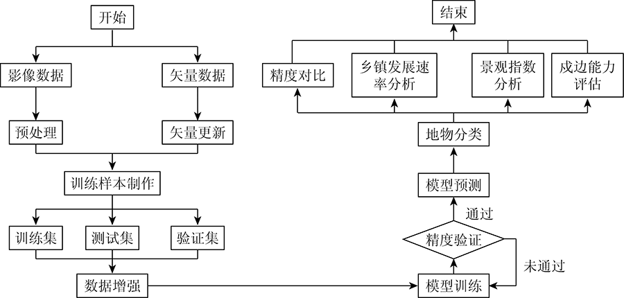
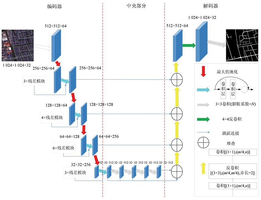
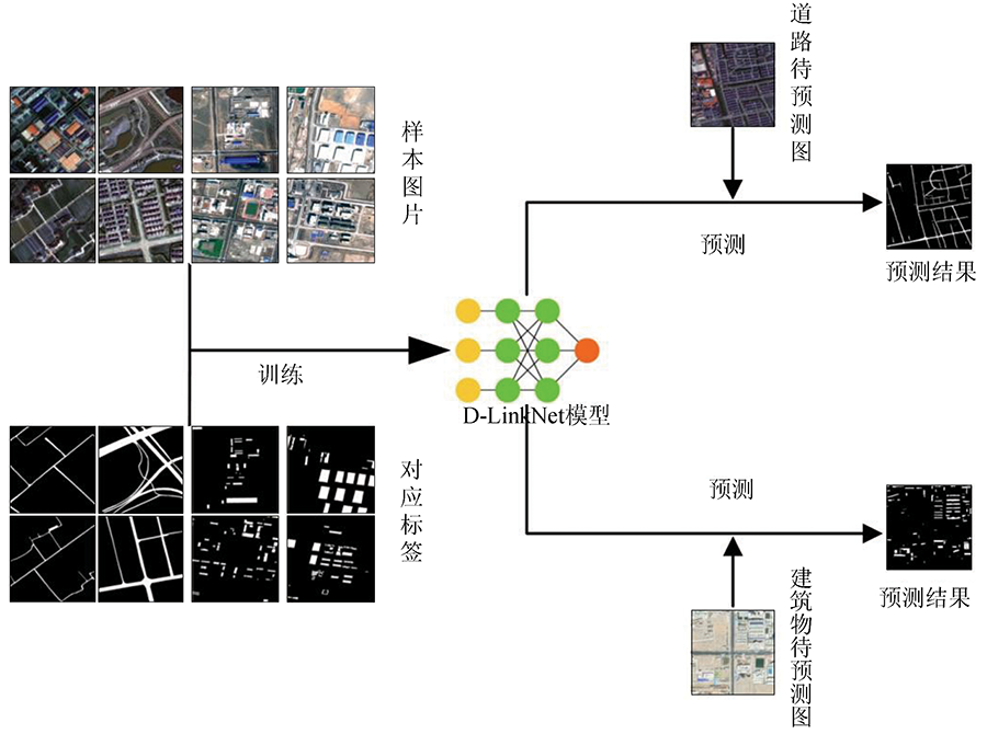
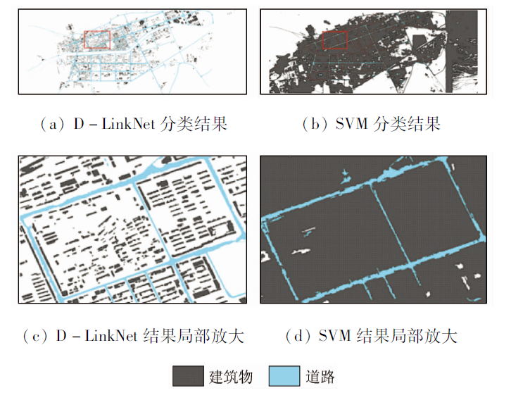
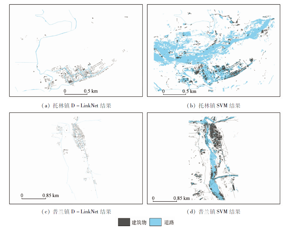
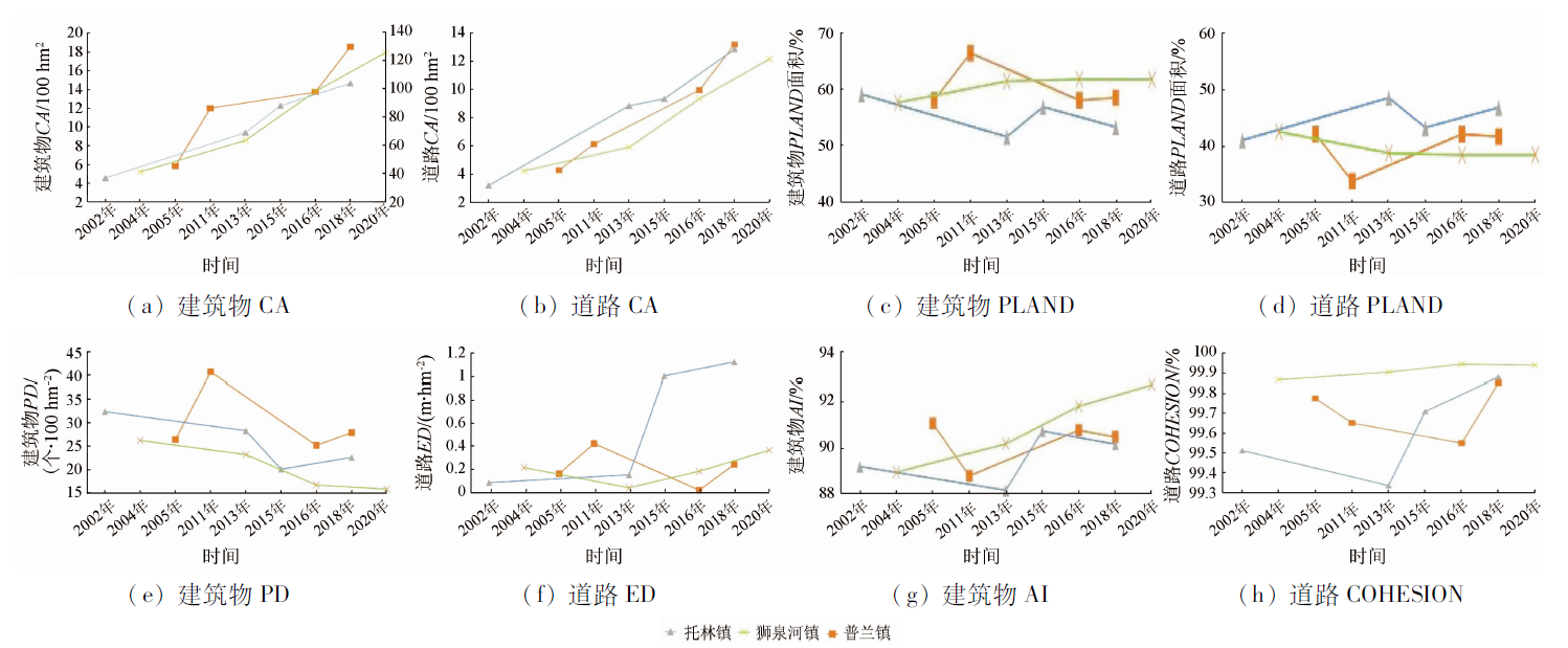
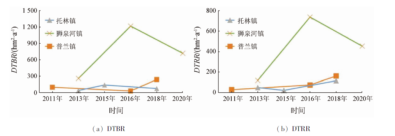
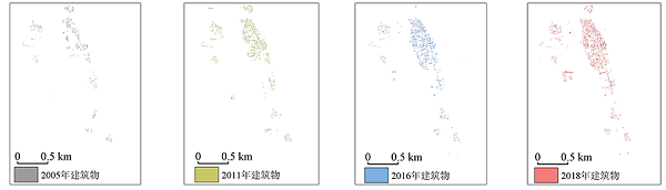
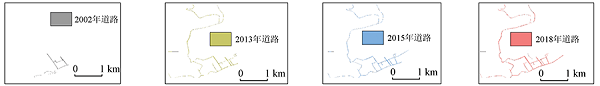
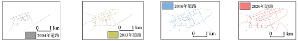
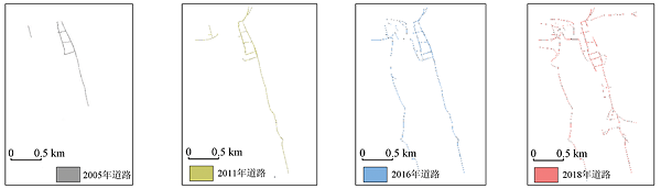
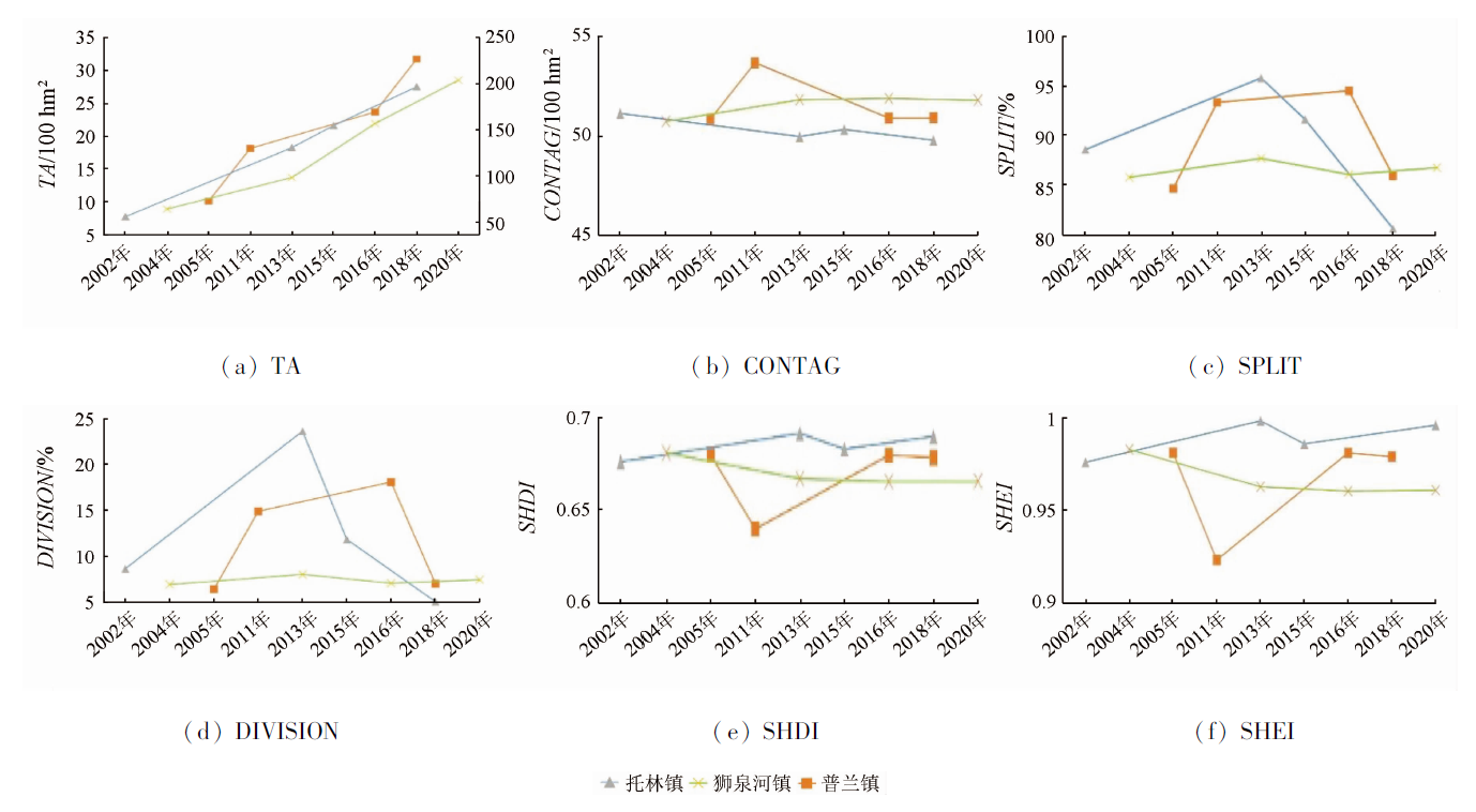
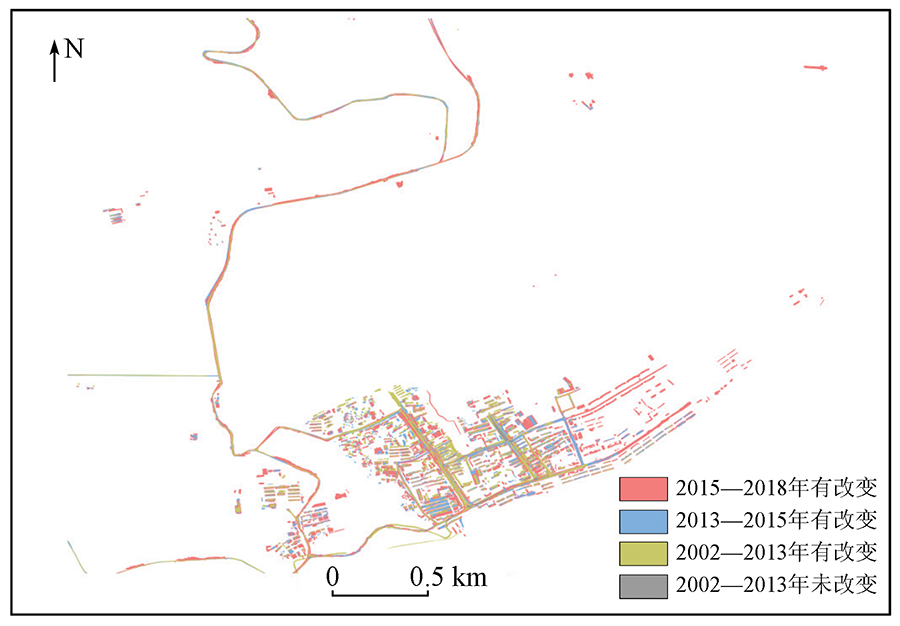
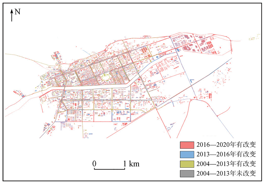
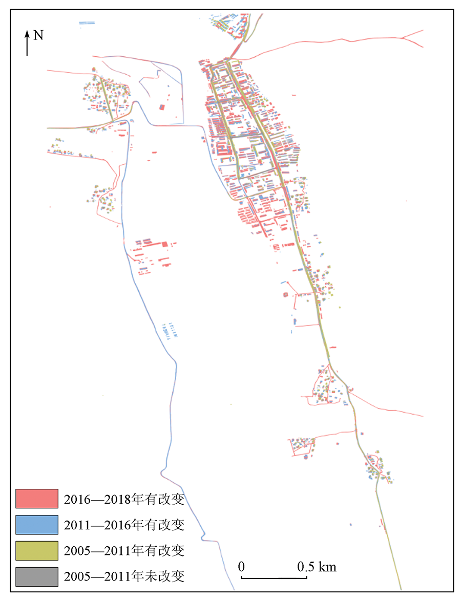
Abstract In order to explore the development trend of border cities in China and assess the city’s border defense capability, the D-LinkNet34 deep learning algorithm is used to automate the extraction of buildings and roads in Tuolin, Shiquanhe and Pulan towns in Tibet Autonomous Region, and to analyze the development trend and border defense capability of border towns based on landscape index and population size. Analysis results show that: ① The extraction method based on D-LinkNet deep learning network can effectively further classify urban construction land, with average total progress of more than 80% and IOU above 70%.② The distribution of plaques in the towns of Pulan and Shiquanhe shows a trend of aggregation, and the trend of urban expansion weakened. The distribution of plaques in Tuolin Town shows a scattered trend, and the trend of urban expansion is obvious. ③ The building area is linearly related to the resident population, and the building area of Tuolin Town increased by about 68.75%from 2002 to 2018, and the resident population increased by about 39.00%. The building area of Shiquanhe Town increased by about 70.75% from 2004 to 2020, while the resident population increased by about 68.44%. The building area of Pulan Town increased by about 68.36% from 2005 to 2018, while the resident population increased by about 25.04%. This study provides a new method for quantitative evaluation of the expansion characteristics and border defense capability of border cities, as well as a reference for building China’s border defense capability.
|
| Keywords
remote sensing
border towns
urban development
landscape index
D-LinkNet
|
|
|
|
Corresponding Authors:
LIU Jilei
E-mail: 505474279@qq.com;liujilei@ppsuc.edu.cn
|
|
Issue Date: 20 June 2022
|
|
|
| [1] |
窦红涛, 齐亚楠, 贾若祥. 支持边境地区加快发展的思路和对策[J]. 中国发展观察, 2020, 249(21):39-43.
|
| [1] |
Dou H T, Qi Y N, Jia R X. Thoughts and countermeasures to accelerate the development of border areas[J]. China Development Observation, 2020, 249(21):39-43.
|
| [2] |
史诗悦, 倪佳瑜. 系统论视域下新时代党的治藏方略的价值意蕴与形成审思——基于中央第七次西藏工作座谈会精神[J]. 西藏民族大学学报(哲学社会科学版), 2021, 42(1):8-14,153.
|
| [2] |
Shi S Y, Ni J Y. The value implication and formation of the party strategy of governing Tibet in the new era from the perspective of system theory[J]. Journal of Xizang Minzu University(Philosophy and Social Sciences Edition), 2021, 42(1):8-14,153.
|
| [3] |
杨明洪, 王周博. 我国陆地边境地区“空心化”的类型、成因与治理[J]. 四川师范大学学报(社会科学版), 2020, 47(6):13-24.
|
| [3] |
Yang M H, Wang Z B. Types,causes and governance of “hollowing” in China’s land border areas[J]. Journal of Sichuan Normal University (Social Sciences Edition), 2020, 47(6):13-24.
|
| [4] |
方盛举, 赵若州. 国家安全视角下边境城镇的戍边功能及其开发[J]. 哈尔滨工业大学学报(社会科学版), 2020, 22(5):1-8.
|
| [4] |
Fang S J, Zhao R Z. The border-town’s garrison role and development fromthe perspective of national security[J]. Journal of Harbin Institute of Technology (Social Science Edition), 2020, 22(5):1-8.
|
| [5] |
陈宝行, 孙小涛, 宋红丽. 济南市中心城区空间扩张特征与机理[J/OL]. 测绘地理信息, 2020:1-5[2021-05-18].
|
| [5] |
Chen B X, Sun X T, Song H L. The characteristics and mechanism of spatial expansion in Jinan City center[J/OL]. Journal of Geomatics, 2020:1-5[2021-05-18].
|
| [6] |
陈明发, 刘帆, 赵耀龙, 等. 1987—2017年粤港澳大湾区城市群的不透水地表扩张与梯度演化[J]. 地球信息科学学报, 2021, 23(3):443-455.
doi: 10.12082/dqxxkx.2021.200195
|
| [6] |
Chen M F, Liu F, Zhao Y L, et al. The expansion and gradient evolution of impervious surface within the Guangdong - HongKong - Macao Greater Bay Area from 1987 to 2017[J]. Geo-Information Science, 2021, 23(3):443-455.
|
| [7] |
张秋仪, 高银宝, 张杨, 等. 海岛型城市建成区扩张特征及空间演化模式——以厦门岛(2002—2018年)为例[J]. 福建师范大学学报(自然科学版), 2021, 37(1):98-106.
|
| [7] |
Zhang Q Y, Gao Y B, Zhang Y, et al. Spatial process,motivation and model of the expansion of built-up areas of island city:A case study of Xiamen Island (2002—2018)[J]. Journal of Fujian Normal University(Natural Science Edition), 2021, 37(1):98-106.
|
| [8] |
陈菲尔, 杨武年. 郑州大都市区城市发展格局演变——基于DMSP/OLS夜间灯光数据[J]. 西华师范大学学报(自然科学版), 2021, 42(2):167-173.
|
| [8] |
Chen F E, Yang W N. Evolution of urban development pattern in Zhengzhou metropolitan area:Based on DMSP/OLS night light data[J]. Journal of China West Normal University(Natural Science), 2021, 42(2):167-173.
|
| [9] |
宋艳华, 焦利民, 刘稼丰, 等. 城市扩张程度的影响因素分析——以武汉市为例[J]. 武汉大学学报(信息科学版), 2021, 46(3):417-426.
|
| [9] |
Song Y H, Jiao L M, Liu J F, et al. Analysis of the factors affecting the degree of urban expansion:Taking Wuhan City as an example[J]. Geomatics and Information Science of Wuhan University, 2021, 46(3):417-426.
|
| [10] |
周润芳, 周亮. 中国典型边境城市空间扩张特征分析[J]. 测绘科学, 2019, 44(9):54-60.
|
| [10] |
Zhou R F, Zhou L. Analysis of spatial expansion characteristics of typical Chinese border cities[J]. Science of Surveying and Mapping, 2019, 44(9):54-60.
|
| [11] |
Vani M, Prasad P R C. Assessment of spatio-temporal changes in land use and land cover,urban sprawl,and land surface temperature in and around Vijayawada City,India[J]. Environment,Development and Sustainability, 2020, 22(4):3079-3095.
doi: 10.1007/s10668-019-00335-2
url: https://doi.org/10.1007/s10668-019-00335-2
|
| [12] |
Robert S, Fox D, Boulay G, et al. A framework to analyse urban sprawl in the French Mediterranean coastal zone[J]. Regional Environmental Change, 2019, 19(2):559-572.
doi: 10.1007/s10113-018-1425-4
url: https://doi.org/10.1007/s10113-018-1425-4
|
| [13] |
Kovacs Z, Farkas Z J, Egedy T, et al. Urban sprawl and land conversion in post-socialist cities:The case of metropolitan Budapest[J]. Cities, 2019, 92(SEPa):71-81.
|
| [14] |
Canedoli C, Crocco F, Comolli R, et al. Landscape fragmentation and urban sprawl in the urban region of Milan[J]. Landscape Research, 2018, 43(5):632-651.
doi: 10.1080/01426397.2017.1336206
url: https://www.tandfonline.com/doi/full/10.1080/01426397.2017.1336206
|
|
Viewed |
|
|
|
Full text
|
|
|
|
|
Abstract
|
|
|
|
|
Cited |
|
|
|
|
| |
Shared |
|
|
|
|
| |
Discussed |
|
|
|
|
 2022,
Vol. 34
2022,
Vol. 34