|
|
|
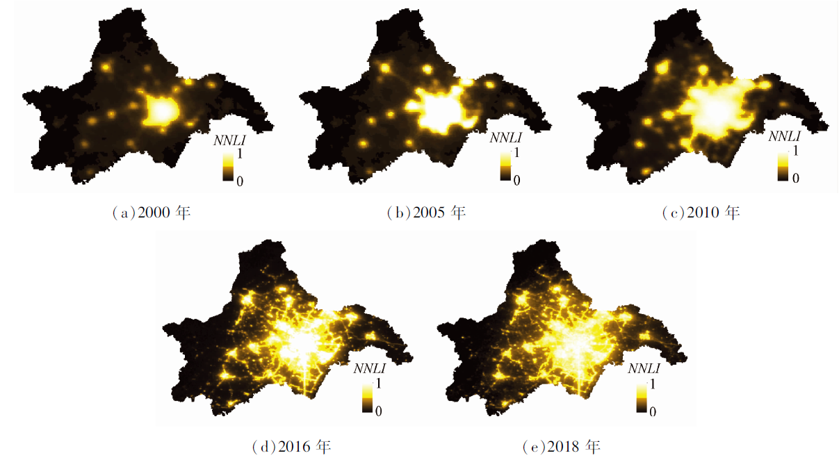
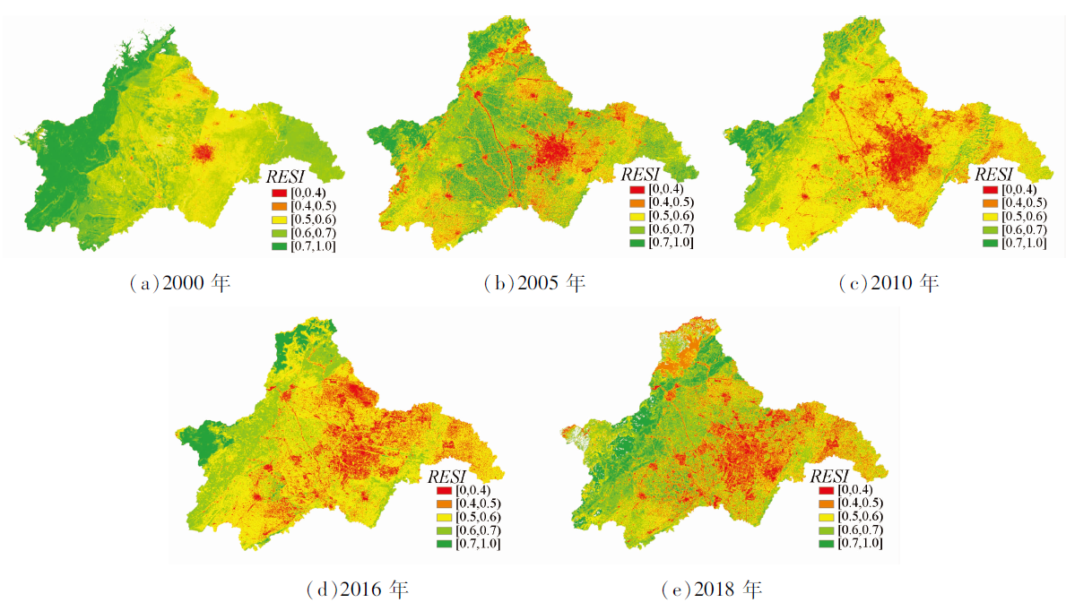
Abstract The scientific assessment of the overall status of the interactions between the urbanization and the ecological environment in Chengdu is of great significance for optimizing the pace and quality of urbanization and improving the quality of the ecological environment. This study adopted the nighttime light and Landsat remote sensing data obtained from the DMSP/OLS and the NPP/VIIRS. Based on these data, the normalized night light index (NNLI) characterizing the urbanization process and the remote sensing ecological index (RSEI) characterizing the ecological quality were constructed, respectively. Then, the two indices were combined into a coupling coordination degree model for evaluation of the coordination between the urbanization process and the ecological environment quality. The study results are shown as follows. The urbanization process in Chengdu had been accelerating from 2000 to 2018, with the NNLI increasing from 0.15 in 2000 to 0.81 in 2018. By contrast, the quality of the ecological environment was negatively affected by the urbanization process and showed a downward trend in some areas, with the RSEI decreasing from 0.63 in 2000 to 0.58 in 2018. The coupling coordination degree of urbanization and ecological environment in Chengdu was gradually improved. From 2000 to 2018, the coupling coordination state entered the stage of good coordination from imbalance. However, the overall urbanization process in Chengdu is ahead of the development of the ecological environment, which is lagging behind.
|
| Keywords
remote sensing
coupling
ecological environment
RSEI index
|
|
|
|
Issue Date: 27 December 2022
|
|
|
| [1] |
秦艳丽, 时鹏, 何文虹, 等. 西安市城市化对景观格局及生态系统服务价值的影响[J]. 生态学报, 2020, 40(22): 8239-8250.
|
| [1] |
Qin Y L, Shi P, He W H, et al. Influence of urbanization on landscape pattern and ecosystem service value in Xi’an City[J]. Acta Ecologica Sinica, 2020, 40(22): 8239-8250.
|
| [2] |
裴立山, 胡强光. 沈阳市城市化与水生态环境的耦合协调发展测度评估[J]. 黑龙江水利科技, 2021, 49(3): 86-88.
|
| [2] |
Pei L S, Hu Q G. Measurement and evaluation of coupling and coordinated development of urbanization and water ecological environment in Shenyang City[J]. Heilongjiang Science and Technolo-gy of Water Conservancy, 2021, 49(3): 86-88.
|
| [3] |
孙立双, 韩耀辉, 谢志伟, 等. 采用夜光遥感数据提取城市建成区的邻域极值法[J]. 武汉大学学报(信息科学版), 2020, 45(10): 1619-1625.
|
| [3] |
Sun L S, Han Y H, Xie Z W, et al. Neighborhood extremum method of extracting urban built-up area using nighttime lighting data[J]. Geomatics and Information Science of Wuhan University, 2020, 45(10): 1619-1625.
|
| [4] |
李渊, 林锋, 严泽幸. 基于Landsat遥感影像的城市化演变分析——以厦门市为例[J]. 城市建筑, 2019, 16(25): 138-142.
|
| [4] |
Li Y, Lin F, Yan Z X. Analysis of urbanization evolution based on Landsat remote sensing image:A case of Xiamen[J]. Urban Architecture, 2019, 16(25): 138-142.
|
| [5] |
石水源, 谢思梅, 谢荣安. 利用遥感影像土地监测数据的城市化土地利用变化研究——以广宁县为例[J]. 测绘通报, 2018(8): 102-105.
|
| [5] |
Shi S Y, Xie S M, Xie R A. A study on county-level land use change of urbanization using land monitoring data from remote sensing images: Taking Guangning County as an example[J]. Bulletin of Surveying and Mapping, 2018(8): 102-105.
|
| [6] |
徐慧敏, 胡守庚. 夜光遥感视角下的中国城市规模的时空演变[J]. 武汉大学学报(信息科学版), 2021, 46(1): 40-49.
|
| [6] |
Xu H M, Hu S G. Chinese city size evolution under perspective of nighttime light remote sensing[J]. Geomatics and Information Science of Wuhan University, 2021, 46(1): 40-49.
|
| [7] |
朱惠, 张清凌, 张珊. 1992—2017年基于夜光遥感的中亚社会经济发展时空特征分析[J]. 地球信息科学学报, 2020, 22(7): 1449-1462.
doi: 10.12082/dqxxkx.2020.190808
|
| [7] |
Zhu H, Zhang Q L, Zhang S. Spatial and temporal characteristics of socio-economic development in central Asia based on a series of nighttime light images from 1992 to 2017[J]. Journal of Geo-Information Science, 2020, 22(7): 1449-1462.
|
| [8] |
张亚球, 姜放, 纪梦达, 等. 基于遥感指数的区县级生态环境评价[J]. 干旱区研究, 2020, 37(6): 1598-1605.
|
| [8] |
Zhang Y Q, Jiang F, Ji M D, et al. Assessment of the ecological environment at district and county level based on remote sensing index[J]. Arid Zone Research, 2020, 37(6): 1598-1605.
|
| [9] |
徐涵秋. 城市遥感生态指数的创建及其应用[J]. 生态学报, 2013, 33(24): 7853-7862.
|
| [9] |
Xu H Q. A remote sensing urban ecological index and its application[J]. Acta Ecologica Sinica, 2013, 33(24): 7853-7862.
|
| [10] |
路娟, 张勇. 长江经济带城市化与生态环境耦合、协调特征及时空演化规律研究[J]. 四川师范大学学报(社会科学版), 2018, 45(4): 85-93.
|
| [10] |
Lu J, Zhang Y. City urbanization along the Yangtze River economic zone, ecological environment coordination and their spatial evolution law[J]. Journal of Sichuan Normal University (Social Sciences Edition), 2018, 45(4): 85-93.
|
| [11] |
翁异静, 周祥祥, 张思哲. 新型城市化与生态环境耦合协调时空特征研究——以长江经济带为例[J]. 林业经济, 2020, 42(11): 63-74.
|
| [11] |
Weng Y J, Zhou X X, Zhang S Z. Research on the coupling and coordination of new urbanization and ecological environment:A case study of the Yangtze River economic belt[J]. Forestry Economics, 2020, 42(11): 63-74.
|
| [12] |
陈晋, 卓莉, 史培军, 等. 基于DMSP/OLS数据的中国城市化过程研究——反映区域城市化水平的灯光指数的构建[J]. 遥感学报, 2003, 7(3),168-175.
|
| [12] |
Chen J, Zhuo L, Shi P J, et al. The study on urbanization process in China based on DMSP/OLS data: Development of a light index for urbanization level estimation[J]. Journal of Remote Sensing, 2003, 7(3), 168-175.
|
| [13] |
刘智才, 徐涵秋, 李乐, 等. 基于遥感生态指数的杭州市城市生态变化[J]. 应用基础与工程科学学报, 2015, 23(4): 728-739.
|
| [13] |
Liu Z C, Xu H Q, Li L, et al. Ecological change in the Hangzhou area using the remote sensing based ecological index[J]. Journal of Basic Science and Engineering, 2015, 23(4): 728-739.
|
| [14] |
廖李红, 戴文远, 黄华富, 等. 基于DMSP/OLS和Landsat数据的城市化与生态环境耦合协调分析[J]. 福建师范大学学报(自然科学版), 2018, 34(6): 94-103.
|
| [14] |
Liao L H, Dai W Y, Huang H F, et al. Coupling coordination analysis of urbanization and eco-environment system in Jinjiang using Landsat series data and DMSP/OLS nighttime light data[J]. Journal of Fujian Normal University (Natural Science Edition), 2018, 34(6): 94-103.
|
| [15] |
王少剑, 方创琳, 王洋. 京津冀地区城市化与生态环境交互耦合关系定量测度[J]. 生态学报, 2015, 35(7): 2244-2254.
|
| [15] |
Wang S J, Fang C L, Wang Y. Quantitative investigation of the interactive coupling relationship between urbanization and eco-environment[J]. Acta Ecologica Sinica, 2015, 35(7): 2244-2254.
|
| [16] |
马廷. 夜光遥感大数据视角下的中国城市化时空特征[J]. 地球信息科学学报, 2019, 21(1): 59-67.
doi: 10.12082/dqxxkx.2019.180361
|
| [16] |
Ma T. Spatiotemporal characteristics of urbanization in China from the perspective of remotely sensed big data of nighttime light[J]. Journal of Geo-Information Science, 2019, 21(1): 59-67.
|
|
Viewed |
|
|
|
Full text
|
|
|
|
|
Abstract
|
|
|
|
|
Cited |
|
|
|
|
| |
Shared |
|
|
|
|
| |
Discussed |
|
|
|
|
 2022,
Vol. 34
2022,
Vol. 34
 ), LIU Hanhu(