|
|
 |
|

|
|
|
Remote sensing-based identification and potential evaluation of the mineralization elements of calcrete-hosted uranium deposits in Saudi Arabia |
GUO Bangjie1( ), PAN Wei2, ZHANG Chuang2, ABDULLAH I. Nabhan3, HASSAN Zowawi3 ), PAN Wei2, ZHANG Chuang2, ABDULLAH I. Nabhan3, HASSAN Zowawi3 |
1. China Institute of Nuclear Industry Strategy, Beijing 100048, China
2. Beijing Research Institute of Uranium Geology, Beijing 100029, China
3. Saudi Geological Survey, Jeddah 21514, Saudi Arabia |
|
|
|
|
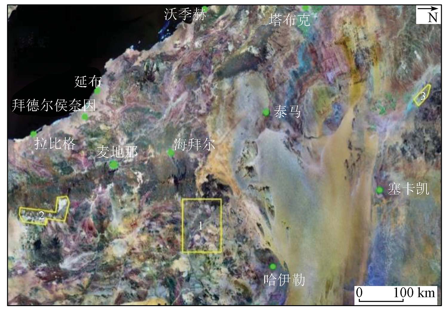
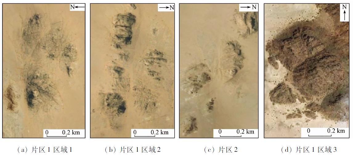
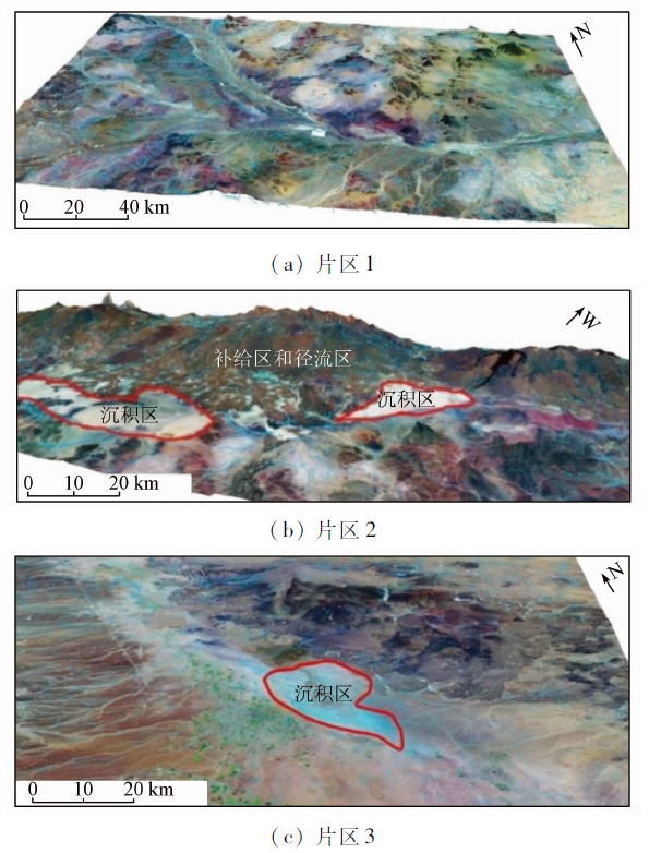
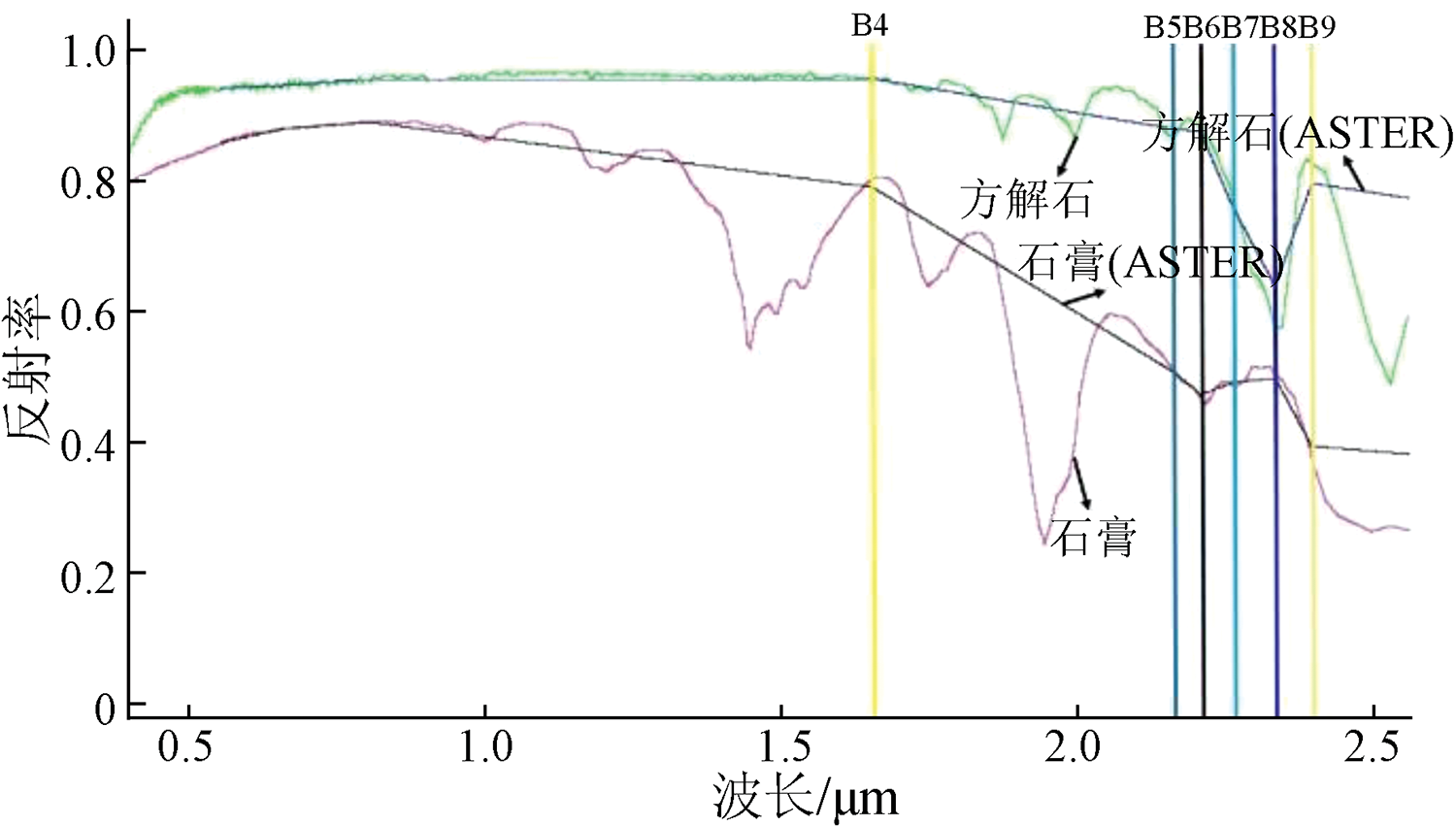
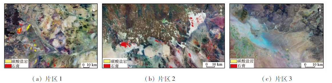
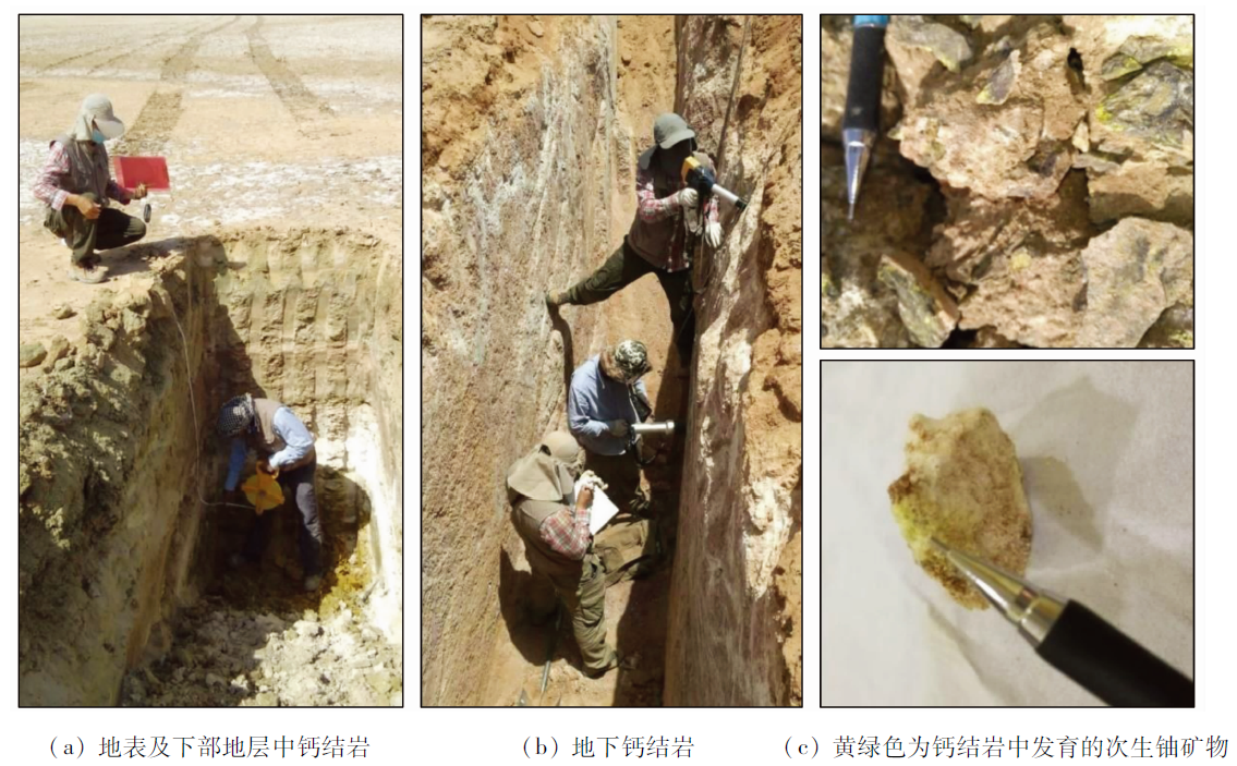
Abstract This study aims at the identification and potential evaluation of the mineralization elements of calcrete-hosted uranium deposits in Saudi Arabia through the exploration of calcrete-hosted uranium deposits in the uranium exploration project of China and Saudi Arabia. Based on satellite (ASTER) remote sensing data and DEM data, the uranium metallogenic conditions of three calcrete areas were compared and analyzed using methods including visual discrimination, hydrological analysis, and principal component analysis and techniques including uranium source evaluation, source-pathway-trap system division, and ore-bearing rock identification. The results show that Area 2 has the most complete uranium metallogenic conditions in terms of uranium source and source-pathway-trap conditions, Area 1 lacks a good sedimentary basin as a drainage area, and Area 3 lacks a good uranium source. Accordingly, the following conclusions were drawn. The integrity of the source-pathway-trap system is crucial and indispensable for the metallogenesis of calcrete-hosted uranium deposits. Moreover, high-quality uranium sources and sedimentary environments are conducive to the formation of large-scale calcrete-hosted uranium deposits. The duration of uranium enrichment and accumulation directly affects the scale of calcrete-hosted uranium deposits. The favorable sedimentary environment for calcrete-hosted uranium deposits is an evaporative lake (playa) with large uranium sources in the study areas of Saudi Arabia. Therefore, this study can guide the exploration of calcrete-hosted uranium deposits in similar areas.
|
| Keywords
remote sensing
calcrete-hosted uranium deposit
source-pathway-trap system
metallogenic conditions
Saudi Arabia
|
|
|
|
Issue Date: 27 December 2022
|
|
|
| [1] |
余达淦, 吴仁贵, 陈培荣. 铀资源地质学[M]. 哈尔滨: 哈尔滨工程大学出版社, 2004.
|
| [1] |
Yu D G, Wu R G, Chen P R. Uranium geology[M]. Harbin: Harbin Engineering University Press, 2004.
|
| [2] |
Butt C R M, Mann A W, Horwitz R C. Regional setting,distribution and genesis of surficial uraniumdeposits in calcretes and associates sediments in western Australia[C]// Surficial Uranium Deposits,IAEA TECDOC-322.IAEA,Vienna, 1984:121-127.
|
| [3] |
Subhash J, Ian C R, Evgeniy B, et al. Basin-related uranium mineral systems in Australia:A review of critical features[J]. Ore Geo-logy Reviews, 2015, 76:360-394.
|
| [4] |
Carlisle D. Concentration of uranium and vanadium in calcretes and gypcretes[J]. Geological Society, 1983, 11:185-195.
doi: 10.1144/GSL.SP.1983.011.01.19
url: https://www.lyellcollection.org/doi/10.1144/GSL.SP.1983.011.01.19
|
| [5] |
Arakel A V. Carnotite mineralization in inland drainage areas of Australia[J]. Ore Geology Reviews, 1988, 3 (1-3):289-311.
doi: 10.1016/0169-1368(88)90023-6
url: https://linkinghub.elsevier.com/retrieve/pii/0169136888900236
|
| [6] |
Bowell R J, Booysens M, Pedley A, et al. Characterization of carnotite uranium deposit in Calcrete Channels,Trekkopje,Namibia[C]// Proceedings of Africa Uncovered:Mineral Resources for the Future,SEG-GSSA Conference, 2008:114-121.
|
| [7] |
Hou B, Fabris, A J, Keeling, J L, et al. Cainozoic palaeochannels hosted uranium and current exploration methods,South Australia[J]. MESA Journal, 2007(46):34-39.
|
| [8] |
车永飞, 张云龙, 赵英俊, 等. 航空γ能谱测量数据在西澳伊尔岗地区钙结岩型铀矿勘查中的应用[J]. 铀矿地质, 2015, 31(1):44-51.
|
| [8] |
Che Y F, Zhang Y L, Zhao Y J, et al. Application of airborne spectrometry data to the exploration of calcrete-hosted uranium deposit in Yilgarn area western Australia[J]. Uranium Geology, 2015, 31(1): 44-51.
|
| [9] |
顾大钊, 许志斌, 范洪海, 等. 纳米比亚不同类型铀矿床成因初探[J]. 矿产勘查, 2015, 6(4):471-477.
|
| [9] |
Gu D Z, Xu Z B, Fan H H, et al. Discussion of deposit genesis of different types of uranium deposits in Namibia[J]. Mineral Exploration, 2015, 6(4):471-477.
|
| [10] |
李克让. 西北地区钙结岩(膏结岩)特征及铀成矿条件初析[J]. 铀矿地质, 1988, 4(1):14-18.
|
| [10] |
Li K R. The characteristics of calcrete(Gypcrete) and a preliminary analysis of uranium ore forming conditions in northwest district of China[J]. Uranium Geology, 1988, 4(1):14-18.
|
| [11] |
李克让. 西北钙(膏)结岩型铀矿化特征和成矿条件[J]. 华东地质学院学报, 1990, 13(2):24-30.
|
| [11] |
Li K R. Feature of uranium mineralization and mineral-formation condition of callche type in Northwest[J]. Journal of East China Institute of Technology, 1990, 13(2): 24-30.
|
| [12] |
Fares H, Philip G, Abdulaty S. Metallogenic evolution of uranium deposits in the middle east and north Africa deposits[J]. Journal of African Earth Sciences, 2016, 114: 30-42.
doi: 10.1016/j.jafrearsci.2015.11.009
url: https://linkinghub.elsevier.com/retrieve/pii/S1464343X15301047
|
| [13] |
Rishikesh B, Kalimuthu R, Ramakrishnan D. Spectral pathways for exploration of secondary uranium:An investigation in the desertic tracts of Rajasthan and Gujarat,India[J]. Advances in Space Research, 2015, 56:1613-1626.
doi: 10.1016/j.asr.2015.07.015
url: https://linkinghub.elsevier.com/retrieve/pii/S0273117715005177
|
| [14] |
Johnson, P R. Explanatory notes to the map of proterozoic geology of western Saudi Arabia[R]. Saudi Geological Survey Technical Report SGS-TR-2006-4, 2006:62.
|
| [15] |
Al-Anazi E, Al-Saleh A. Surface dispersion of uranium in the Al-Hayt area,NE Arabian shield[J]. Journal of Environmental Radioactivity, 2013, 124:214-226.
doi: 10.1016/j.jenvrad.2013.05.010
pmid: 23827231
|
| [16] |
Quick J E, Doebrich J L. Geologic map of the Wadi Ash Shu’bah Quadrangle,sheet 26E,kingdom of Saudi Arabia(Scale 1:250 000,with text)[M]. Saudi Arabian Deputy Ministry for MineralResources Geoscience Map GM 108C, 1986:23.
|
| [17] |
娄峰, 李宏卫, 陈光明, 等. 花岗岩演化与铀钍元素富集的关系: 以粤北贵东岩体为例[J]. 地学前缘, 2011, 18(1): 110-117.
|
| [17] |
Lou F, Li H W, Chen G M, et al. The relationship between granite evolution and uranium thorium enrichment:An example from the Guidong granite body,north Guangdong Province[J]. Earth Science Frontiers, 2011, 18(1):110-117.
|
| [18] |
叶发旺. ASTER数据与ETM数据蚀变信息提取的对比研究——以巴什布拉克铀矿区油气还原蚀变分析为例[J]. 地球信息科学学报, 2009, 11(3):274-281.
|
| [18] |
Ye F W. Discussion on applicational comparison between new type of multi-spectral ASTER data and ETM+data:A case study on extracting the reduced alteration information of gas and oil in Bashibulake uranium ore district[J]. Journal of Geo-Information Science, 2009, 11(3):274-281.
doi: 10.3724/SP.J.1047.2009.00274
url: http://pub.chinasciencejournal.com/article/getArticleRedirect.action?doiCode=10.3724/SP.J.1047.2009.00274
|
| [19] |
王俊虎, 张杰林, 张静波. 基于ASTER热红外数据的SiO2含量反演在某矿田信息提取中的应用[J]. 铀矿地质, 2010, 26(1): 306-311.
|
| [19] |
Wang J H, Zhang J L, Zhang J B, et al. SiO2 content retrieving based on ASTER thermal data and its application in substracting metallogenic factor of a uranium deposit[J]. Uranium Geology, 2010, 26(1):306-311.
|
| [20] |
唐淑兰, 曹建农, 王国强, 等. 结合小波包变换和随机森林的ASTER蚀变信息提取[J]. 地质学报, 2021, 95(3): 924-933.
|
| [20] |
Tang S L, Cao J N, Wang G Q, et al. Aster alteration information extraction based on wavelet packet transform and random forest[J]. Acta Geologica Sinica, 2021, 95(3): 924-933.
|
| [21] |
韩海辉, 王艺霖, 张转, 等. 东昆仑浅覆盖区遥感蚀变异常提取与分析[J]. 遥感信息, 2018, 33(4): 72-79.
|
| [21] |
Han H H, Wang Y L, Zhang Z, et al. Extraction and analysis of remote sensing alteration anomaly at shallow loess covering area in East Kunlun[J]. Remote Sensing Information, 2018, 33(4): 72-79.
|
| [22] |
鲁立辉, 许荣科, 郑有业, 等. 基于OLI和ASTER数据的蚀变信息提取分析与对比——以青海都兰通突尔铅锌多金属矿区为例[J]. 地质与勘探, 2019, 55(2): 600-607.
|
| [22] |
Lu L H, Xu R K, Zheng Y Y, et al. Analysis and comparison of extracting alteration information from OLI and ASTER data:An example of the Tongtuer Pb-Zn polymetallic deposit in Dulan,Qinghai Province[J]. Geology and Prospecting, 2019, 55(2): 600-607.
|
| [23] |
张玉君, 曾朝铭, 陈薇. ETM+(TM)蚀变遥感异常提取方法研究与应用——方法选择和技术流程[J]. 国土资源遥感, 2003, 15(2): 44-50.doi:10.6046/gtzyyg.2003.02.11.
doi: 10.6046/gtzyyg.2003.02.11
|
| [23] |
Zhang Y J, Zeng Z M, Chen W. The methods for extraction of alteration anomalies from the ETM+(TM) data and their application:Method selection and technological flow chart[J]. Remote Sensing for Land and Resources, 2003, 15(2): 44-50.doi:10.6046/gtzyyg.2003.02.11.
doi: 10.6046/gtzyyg.2003.02.11
|
| [24] |
肖晨超, 吴小娟, 王大明, 等. 基于烃类微渗漏的油气异常信息提取及远景区预测——以中非Salamat盆地为例[J]. 国土资源遥感, 2019, 31(4): 120-127.doi:10.6046/gtzyyg.2019.04.16.
doi: 10.6046/gtzyyg.2019.04.16
|
| [24] |
Xiao C C, Wu X J, Wang D M, et al. Oil-gas information extraction and prospective area prediction based on hydrocarbon microseepage theory:A case study of Salamat Basin in Central Africa[J]. Remote Sensing for Land and Resources, 2019, 31(4):120-127.doi:10.6046/gtzyyg.2019.04.16.
doi: 10.6046/gtzyyg.2019.04.16
|
| [25] |
Al-Anazi E A. Uranium pollution in the Al-Hayt area,south of the city of Hail.M.Sc.dissertation[R]. King Saud University,Riyadh (unpublished), 2005:212.
|
| [26] |
Al-Jarallah M I. Radon exhalation from granites used in Saudi Arabia[J]. Journal of Environmental Radioactivity, 2001, 53:91-98.
pmid: 11378931
|
|
Viewed |
|
|
|
Full text
|
|
|
|
|
Abstract
|
|
|
|
|
Cited |
|
|
|
|
| |
Shared |
|
|
|
|
| |
Discussed |
|
|
|
|
 2022,
Vol. 34
2022,
Vol. 34