|
|
 |
|

|
|
|
Remote sensing dynamic monitoring and driving factor analysis for the Beijing section of Ming Great Wall |
LIU Hanwei1,2,3( ), CHEN Fulong1,2(), LIAO Yaao4 ), CHEN Fulong1,2(), LIAO Yaao4 |
1. Key Laboratory Digital Earth Science, Aerospace Information Research Institute, Chinese Academy of Sciences, Beijing 100094, China
2. International Research Center of Big Data for Sustainable Development Goals, Beijing 100094, China
3. University of Chinese Academy of Sciences, Beijing 100049, China
4. China University of Geosciences, Beijing 100083, China |
|
|
|
|
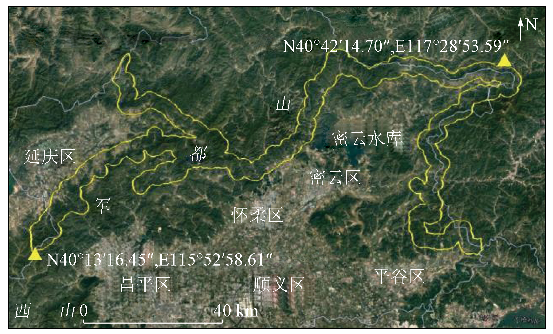
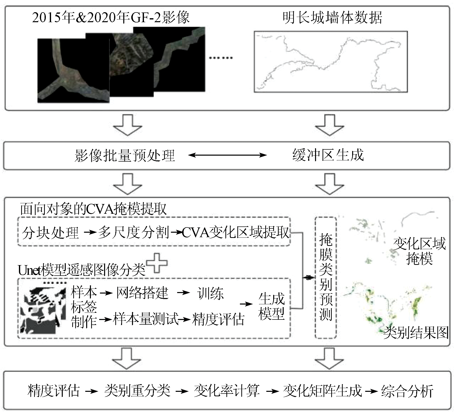
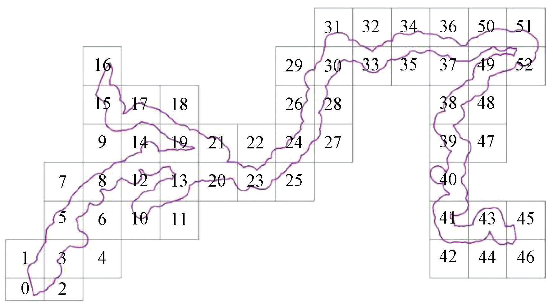
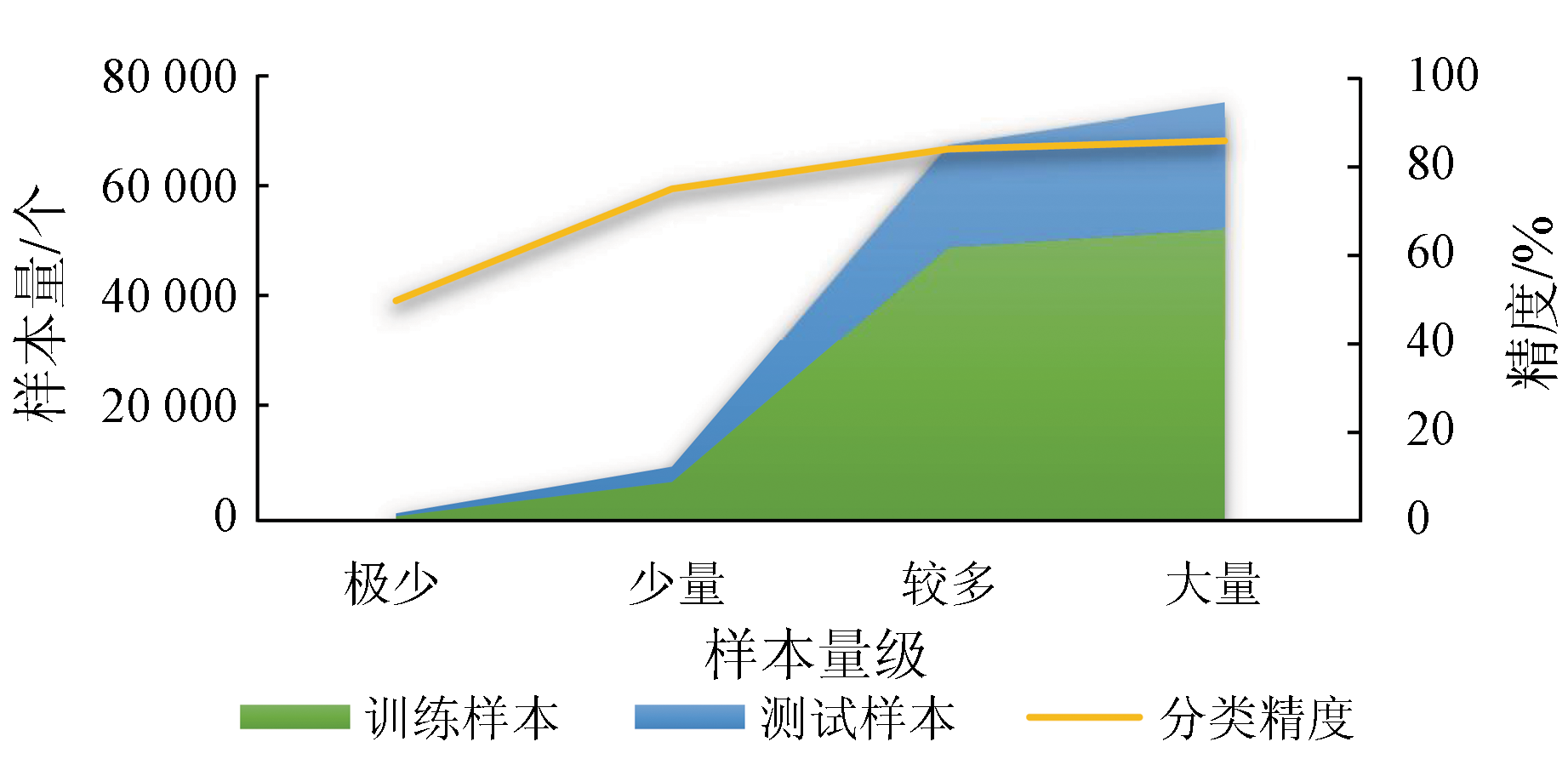
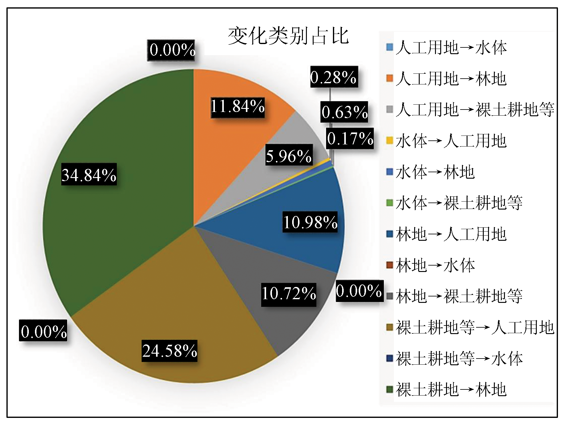
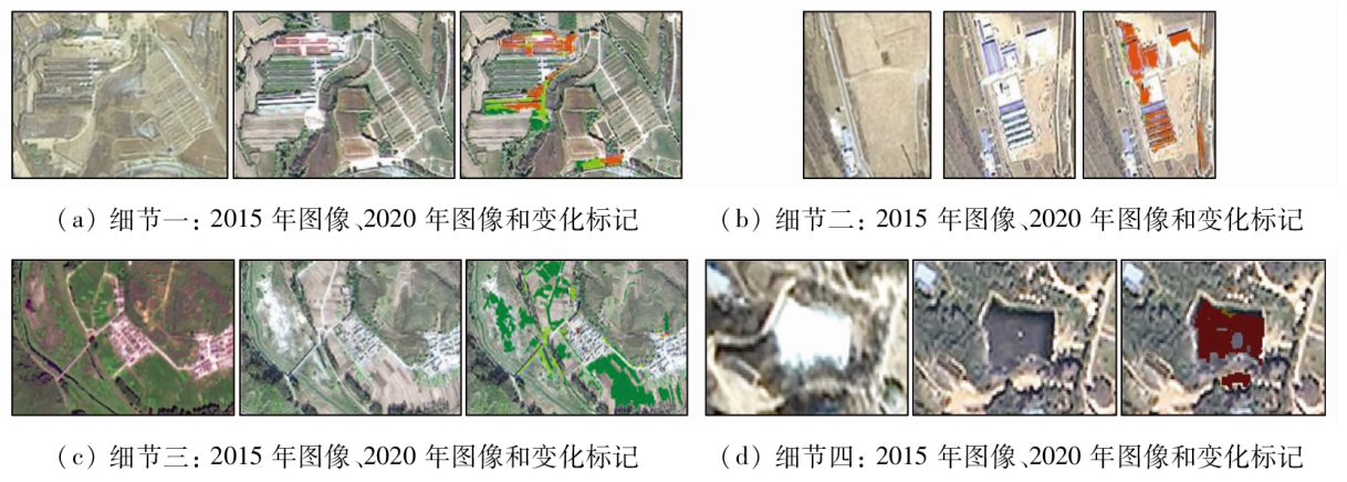
Abstract The coordinated economic and ecological development and the cultural landscape preservation of the Great Wall cultural zone are crucial for regional social sustainability. To meet the need for integrated monitoring and evaluation of large-scale linear cultural heritage, this study proposed a remote sensing dynamic monitoring method that integrates object-oriented change vector analysis and U-net deep learning. Based on the suppression of classified scattered noise and the accurate dynamic description of key regional environmental components, this study achieved the interpretation and information mining of the factors driving cultural landscape changes by combining socio-economic data and remote sensing change detection. Building on the 2-m-resolution GF-2 fused images from 2015 to 2020, the Beijing section of Ming Great Wall was examined through remote sensing change detection of surface elements and quantitative analysis of the land cover change matrix for its landscape corridor using methods including multiresolution segmentation, change vector analysis and extraction, and U-net image classification. The study reveals that the land cover along the Beijing section of Ming Great Wall cultural zone yielded a change rate of 0.098%, primarily manifested in the shift from bare land and farmland to forests and the growth of artificial land. Meanwhile, the ecological environment of the cultural zone exhibited positive development and an overall favorable protection state. The research results will provide technical support for the coordinated economic and ecological development and the sustainable preservation of the cultural landscape along the Beijing section of Ming Great Wall.
|
| Keywords
Ming Great Wall
deep learning
change detection
land cover change rate
spatio-temporal analysis
|
|
|
|
Issue Date: 21 December 2023
|
|
|
| [1] |
汤羽扬, 蔡超, 刘昭祎. 北京市长城文化带保护发展规划编制回顾[C]// 万里长城——庆祝中华人民共和国成立70周年论文集, 2019:36-41.
|
| [1] |
Tang Y Y, Cai C, Liu Z Y. Into Beijing Great Wall culture belt protection and development[C]// The Great Wall:A collection of papers celebrating the 70th anniversary of the founding of the people’s Republic of China, 2019:36-41.
|
| [2] |
Lu D, Mausel P, Brondízio E, et al. Change detection techniques[J]. International Journal of Remote Sensing, 2004, 25(12):2365-2401.
doi: 10.1080/0143116031000139863
url: https://www.tandfonline.com/doi/full/10.1080/0143116031000139863
|
| [3] |
Desclée B, Bogaert P, Defourny P. Forest change detection by statistical object-based method[J]. Remote Sensing of Environment, 2006, 102(1-2):1-11.
doi: 10.1016/j.rse.2006.01.013
url: https://linkinghub.elsevier.com/retrieve/pii/S0034425706000344
|
| [4] |
Huo C, Zhou Z, Lu H, et al. Fast object-level change detection for VHR images[J]. IEEE Geoscience & Remote Sensing Letters, 2010, 7(1):118-122.
|
| [5] |
Li P, Xu H. Land-cover change detection using one-class support vector machine[J]. Photogrammetric Engineering & Remote Sensing, 2010, 76(3):255-263.
|
| [6] |
Duro D C, Franklin S E, Dubé M G. A comparison of pixel-based and object-based image analysis with selected machine learning algorithms for the classification of agricultural landscapes using SPOT-5 HRG imagery[J]. Remote Sensing of Environment, 2012, 118(6):259-272.
doi: 10.1016/j.rse.2011.11.020
url: https://linkinghub.elsevier.com/retrieve/pii/S0034425711004172
|
| [7] |
冯权泷, 牛博文, 朱德海, 等. 土地利用/覆被深度学习遥感分类研究综述[J]. 农业机械学报, 2022, 53(3):1-17.
|
| [7] |
Feng Q L, Niu B W, Zhu D H, et al. Review for deep learning in land use and land cover remote sensing classification[J]. Transactions of the Chinese Society for Agricultural Machinery, 2022, 53(3):1-17.
|
| [8] |
Zhang L, Zhang L, Bo D. Deep Learning for remote sensing data:A technical tutorial on the state of the art[J]. IEEE Geoscience and Remote Sensing Magazine, 2016, 4(2):22-40.
doi: 10.1109/MGRS.2016.2540798
url: http://ieeexplore.ieee.org/document/7486259/
|
| [9] |
Zhu X X, Tuia D, Mou L, et al. Deep learning in remote sensing:A comprehensive review and list of resources[J]. IEEE Geoscience and Remote Sensing Magazine, 2017, 5(4):8-36.
|
| [10] |
袁伟, 周甜, 奚宗顺, 等. MUNet:一种多尺度自适应的遥感语义分割深度学习网络[J]. 测绘科学技术学报, 2020, 37(6):581-588.
|
| [10] |
Yuan W, Zhou T, Xi Z S, et al. MUNet:A multi-branch adaptive deep learning network for remote sensing image semantic segmentation[J]. Journal of Geomatics Science and Technology, 2020, 37(6):581-588.
|
| [11] |
李国清, 柏永青, 杨轩, 等. 基于深度学习的高分辨率遥感影像土地覆盖自动分类方法[J]. 地球信息科学学报, 2021, 23(9):1690-1704.
doi: 10.12082/dqxxkx.2021.200795
|
| [11] |
Li G Q, Bai Y Q, Yang X, et al. Automatic deep learning land cover classification methods of high-resolution remotely sensed images[J]. Journal of Geo-information Science, 2021, 23(9):1690-1704.
|
| [12] |
徐知宇, 周艺, 王世新, 等. 面向GF-2遥感影像的U-Net城市绿地分类[J]. 中国图象图形学报, 2021, 26(3):700-713.
|
| [12] |
Xu Z Y, Zhou Y, Wang S X, et al. U-Net for urban green space classification in Gaofen-2 remote sensing images[J]. Journal of Image and Graphics, 2021, 26(3):700-713.
|
| [13] |
韩星, 韩玲, 李良志, 等. 基于深度学习的高分辨率遥感图像建筑物变化检测[J]. 激光与光电子学进展, 2022, 59(10):55-63.
|
| [13] |
Han X, Han L, Li L Z, et al. Building change detection in high-resolution remote-sensing images based on deep learning[J]. Laser & Optoelectronics Progress, 2022, 59(10):55-63.
|
| [14] |
马晓宇, 张新, 刘吉磊, 等. 基于深度学习的中国边境地区城市发展与安防研究[J]. 自然资源遥感, 2022, 34(2):231-241.doi:10.6046/zrzyyg.2021157.
|
| [14] |
Ma X Y, Zhang X, Liu J L, et al. Research on urban development and security in border areas of China based on deep learning[J]. Remote Sensing for Natural Resources, 2022, 34(2):231-241.doi:10.6046/zrzyyg.2021157.
|
| [15] |
Thuestad A E, Tφmmervik H, Solbφ S A. Assessing the impact of human activity on cultural heritage in Svalbard:A remote sensing study of London[J]. The Polar Journal, 2015, 5(2):428-445.
doi: 10.1080/2154896X.2015.1068536
url: http://www.tandfonline.com/doi/full/10.1080/2154896X.2015.1068536
|
| [16] |
Elfadaly A, Attia W, Qelichi M M, et al. Management of cultural heritage sites using remote sensing indices and spatial analysis techniques[J]. Surveys in Geophysical, 2018, 39(12):1347-1377.
|
| [17] |
王臣立, 徐丹, 林文鹏. 红河哈尼梯田世界文化景观遗产的遥感监测与土地覆盖变化[J]. 生态环境学报, 2021, 30(2):233-241.
doi: 10.16258/j.cnki.1674-5906.2021.02.002
|
| [17] |
Wang C L, Xu D, Lin W P. Remote sensing monitoring and land cover change of the world cultural landscape heritage in Honghe Hani Terrace,China[J]. Ecology and Environmental Sciences, 2021, 30(2):233-241.
|
| [18] |
毛宁, 刘慧平, 刘湘平, 等. 基于RMNE方法的多尺度分割最优分割尺度选取[J]. 国土资源遥感, 2019, 31(2):10-16.doi:10.6046/gtzyyg.2019.02.02.
|
| [18] |
Mao N, Liu H P, Liu X P, et al. Optimal scale selection for multi-scale segmentation based on RMNE method[J]. Remote Sensing for Natural Resources, 2019, 31(2):10-16.doi:10.6046/gtzyyg.2019.02.02.
|
| [19] |
王晓慧, 谭炳香, 李世明, 等. 基于面向对象多特征变化向量分析法的森林资源变化检测[J]. 林业科学研究, 2021, 34(1):98-105.
|
| [19] |
Wang X H, Tan B X, Li S M, et al. Object-oriented forest change detection based on multi-feature change vector analysis[J]. Forest Research, 2021, 34(1):98-105.
|
| [20] |
Maggiori E, Tarabalka Y, Charpiat G, et al. Fully convolutional neural networks for remote sensing image classification[C]// 2016 IEEE International Geoscience and Remote Sensing Symposium(IGARSS).Beijing,China.IEEE, 2016:5071-5074.
|
| [21] |
Ronneberger O, Fischer P, Brox T. U-Net:Convolutional networks for biomedical image segmentation[J]. International Conference on Medical Image Computing and Computer-Assisted Intervention, Cham:Spnnger, 2015, 18(9351):234-241.
|
| [22] |
Zhao X, Yuan Y, Song M, et al. Use of unmanned aerial vehicle imagery and deep learning unet to extract rice lodging[J]. Sensors (Basel,Switzerland), 2019, 19(18):3859-3872.
doi: 10.3390/s19183859
url: https://www.mdpi.com/1424-8220/19/18/3859
|
| [23] |
杨子生, 杨诗琴, 杨人懿, 等. 基于利用视角的土地资源分类方法探讨[J]. 资源科学, 2021, 43(11):2173-2191.
doi: 10.18402/resci.2021.11.03
|
| [23] |
Yang Z S, Yang S Q, Yang R Y, et al. Classification method of land resources based on land use perspective[J]. Resources Science, 2021, 43(11):2173-2191.
doi: 10.18402/resci.2021.11.03
|
|
Viewed |
|
|
|
Full text
|
|
|
|
|
Abstract
|
|
|
|
|
Cited |
|
|
|
|
| |
Shared |
|
|
|
|
| |
Discussed |
|
|
|
|
 2023,
Vol. 35
2023,
Vol. 35