|
|
|
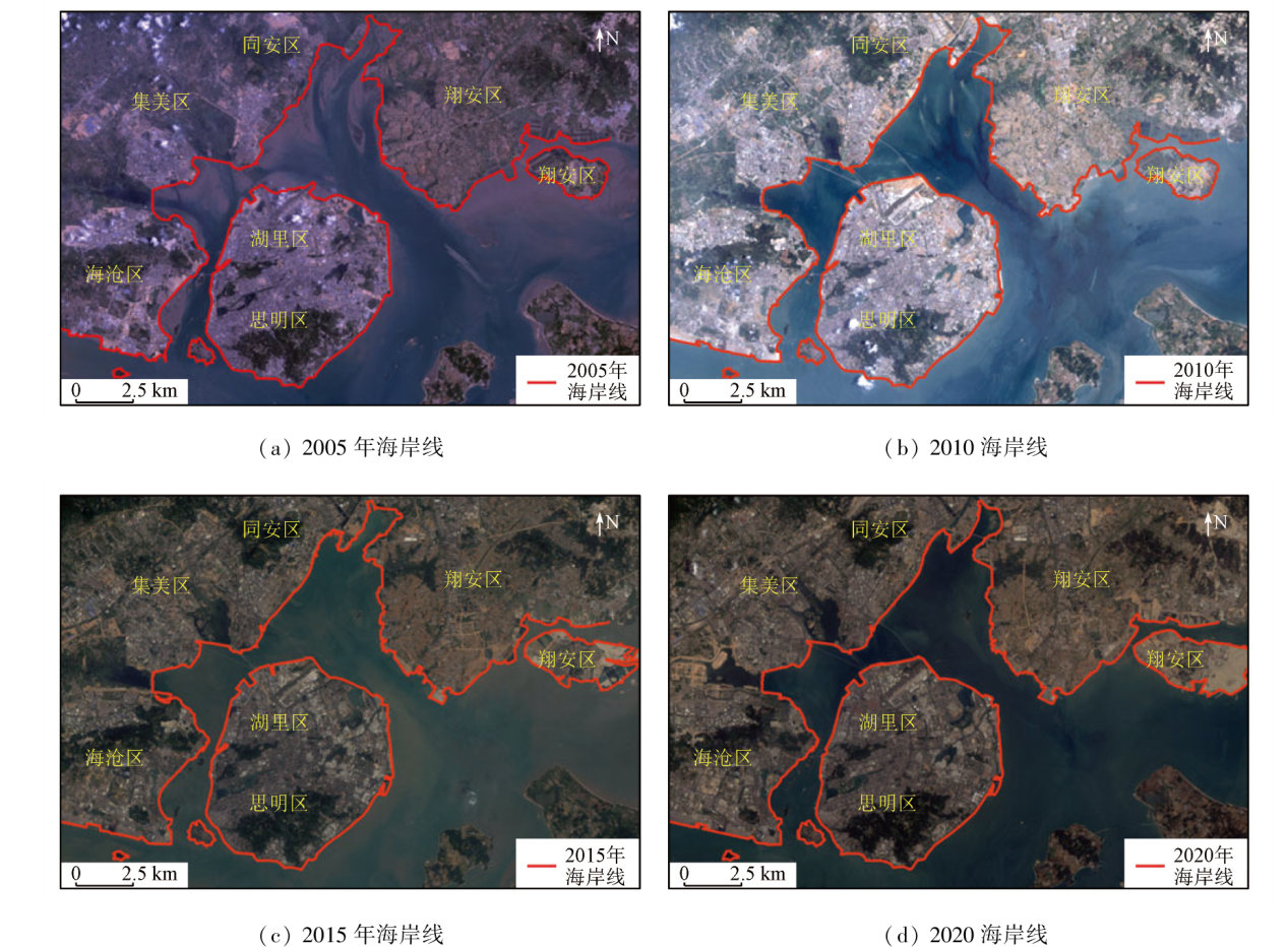
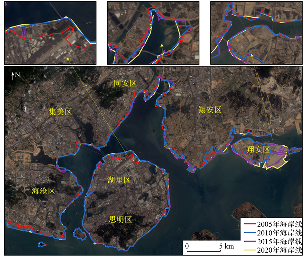
Abstract China boasts long shorelines and abundant marine resources. Xiamen, a coastal city in China, has seen significant changes in its shorelines in recent years due to an increase in activities including port construction, coastal industry, and coastal tourism development. Hence, efficiently and accurately determining the spatio-temporal changes in Xiamen's shoreline holds critical research value and practical significance. This study extracted information on the shorelines from the Landsat remote sensing images in 2005, 2010, 2015, and 2020 using the object-oriented method. Then, it delved into the spatio-temporal evolution of shoreline length, shoreline morphology, and land area changes. The results reveal significant spatio-temporal changes in Xiamen’s shoreline over the 15 years. The shoreline length changed quickly and then moderately, peaking from 2010 to 2015, with an average rate as high as 4.1 km/a, primarily in the vicinity of Dadeng Island and Haixiang Pier. The shoreline morphology tended to be flattened year by year, with the most pronounced changes observed in Huli District. From 2005 to 2020, the land area of Xiamen increased approximately 24.5 km2, with the most significant increase occurring in Xiang’an District. The changes in the shoreline were influenced by many factors, predominantly including population growth, economic development, and the introduction and change of policies.
|
| Keywords
shoreline extraction
Landsat
fractal dimension
Xiamen City
spatio-temporal change
|
|
|
|
Issue Date: 13 March 2024
|
|
|
| [1] |
毋亭, 侯西勇. 海岸线变化研究综述[J]. 生态学报, 2016, 36(4):1170-1182.
|
| [1] |
Wu T, Hou X Y. Review of research on coastline changes[J]. Acta Ecologica Sinica, 2016, 36(4):1170-1182.
|
| [2] |
刘百桥, 孟伟庆, 赵建华, 等. 中国大陆1990—2013年海岸线资源开发利用特征变化[J]. 自然资源学报, 2015, 30(12):2033-2044.
|
| [2] |
Liu B Q, Meng W Q, Zhao J H, et al. Variation of coastline resources utilization in China from 1990 to 2013[J]. Journal of Natural Resources, 2015, 30(12):2033-2044.
|
| [3] |
Solomon S M. Spatial and temporal variability of shoreline change in the Beaufort-Mackenzie region,Northwest Territories,Canada[J]. Geo-Marine Letters, 2005, 25(2):127-137.
doi: 10.1007/s00367-004-0194-x
url: http://link.springer.com/10.1007/s00367-004-0194-x
|
| [4] |
Yu K, Hu C, Muller-Karger F E, et al. Shoreline changes in west-central Florida between 1987 and 2008 from Landsat observations[J]. International Journal of Remote Sensing, 2011, 32(23):8299-8313.
doi: 10.1080/01431161.2010.535045
url: https://www.tandfonline.com/doi/full/10.1080/01431161.2010.535045
|
| [5] |
Sagar S, Roberts D, Bala B, et al. Extracting the intertidal extent and topography of the Australian coastline from a 28 year time series of Landsat observations[J]. Remote Sensing of Environment, 2017, 195:153-169.
doi: 10.1016/j.rse.2017.04.009
url: https://linkinghub.elsevier.com/retrieve/pii/S0034425717301591
|
| [6] |
朱俊凤, 王耿明, 张金兰, 等. 珠江三角洲海岸线遥感调查和近期演变分析[J]. 国土资源遥感, 2013, 25(3):130-137.doi:10.6046/gtzyyg.2013.03.22.
|
| [6] |
Zhu J F, Wang G M, Zhang J L, et al. Remote sensing investigation and recent evolution analysis of Pearl River delta coastline[J]. Remote Sensing for Land and Resources Resources, 2013, 25(3):130-137.doi:10.6046/gtzyyg.2013.03.22.
|
| [7] |
王正军, 张鹰, 陈理凡, 等. 从高分辨率卫星影像挖掘海岸冲淤变化信息的方法[J]. 海洋科学进展, 2012, 30(1):63-68.
|
| [7] |
Wang Z J, Zhang Y, Chen L F, et al. Methods for extracting the information of coastal accretion-erosion variations from high-resolution satellite images[J]. Advances in Marine Science, 2012, 30(1):63-68.
|
| [8] |
张汉女. 基于SVM的海岸线提取方法研究[D]. 长春: 东北师范大学, 2010.
|
| [8] |
Zhang H N. Coastline extraction using support vector machine from remote sensing image[D]. Changchun: Northeast Normal University, 2010.
|
| [9] |
黄海军, 李成治, 郭建军. 卫星影像在黄河三角洲岸线变化研究中的应用[J]. 海洋地质与第四纪地质, 1994, 14(2):29-37.
|
| [9] |
Huang H J, Li C Z, Guo J J. Application of landsat images to the studies of the shoreline changes of the Huanghe River delta[J]. Marine Geology & Quaternary Geology, 1994, 14(2):29-37.
|
| [10] |
马小峰, 赵冬至, 邢小罡, 等. 海岸线卫星遥感提取方法研究[J]. 海洋环境科学, 2007, 26(2):185-189.
|
| [10] |
Ma X F, Zhao D Z, Xing X G, et al. Means of withdrawing coastline by remote sensing[J]. Marine Environmental Science, 2007, 26(2):185-189.
|
| [11] |
叶小敏, 丁静, 徐莹, 等. 渤海湾近30年海岸线变迁与分析[J]. 海洋开发与管理, 2016, 33(2):56-62.
|
| [11] |
Ye X M, Ding J, Xu Y, et al. On the changes of the coastline in Bohai Bay during the last 30 years[J]. Ocean Development and Management, 2016, 33(2):56-62.
|
| [12] |
杨金中, 李志中, 赵玉灵. 杭州湾南北两岸岸线变迁遥感动态调查[J]. 国土资源遥感, 2002, 14(1):23-28.doi:10.6046/gtzyyg.2002.01.06.
|
| [12] |
Yang J Z, Li Z Z, Zhao Y L. The remote sensing dynamic monitoring of Hangzhouwan banks[J]. Remote Sensing for Land and Resources, 2002, 14(1):23-28.doi:10.6046/gtzyyg.2002.01.06.
|
| [13] |
周良勇, 张志珣, 陆凯. 1985—2002年江苏粉砂淤泥质海岸岸线和围海变化[J]. 海洋地质动态, 2010, 26(6):7-11.
|
| [13] |
Zhou L Y, Zhang Z X, Lu K. Shoreline change and reclaimation of silty coast in Jiangsu Province during 1985—2002[J]. Marine Geology Letters, 2010, 26(6):7-11.
|
| [14] |
陈晓英, 张杰, 马毅. 近40年来海州湾海岸线时空变化分析[J]. 海洋科学进展, 2014, 32(3):324-334.
|
| [14] |
Chen X Y, Zhang J, Ma Y. Analysis of the spatial and temporal changes of the coastline in the Haizhou Bay during the past 40 years[J]. Advances in Marine Science, 2014, 32(3):324-334.
|
| [15] |
唐江浪, 李涛, 李刚, 等. 厦门及其邻域近40年海岸线变迁[J]. 海洋地质前沿, 2020, 36(5):14-21.
|
| [15] |
Tang J L, Li T, Li G, et al. Coastiline changes in Xiamen and surrounding areas for the past 40 years[J]. Marine Geology Frontiers, 2020, 36(5):14-21.
|
| [16] |
林松, 俞晓牮, 庄小冰, 等. 厦门岛海岸线分形特性演变规律的研究[J]. 海洋科学进展, 2020, 38(1):121-129.
|
| [16] |
Lin S, Yu X J, Zhuang X B, et al. Fractal characteristics evolution of coastline of the Xiamen Island[J]. Advances in Marine Science, 2020, 38(1): 121-129.
|
| [17] |
吴一全, 刘忠林. 遥感影像的海岸线自动提取方法研究进展[J]. 遥感学报, 2019, 23(4):582-602.
|
| [17] |
Wu Y Q, Liu Z L. Research progress on methods of automatic coastline extraction based on remote sensing images[J]. Journal of Remote Sensing, 2019, 23(4):582-602.
|
| [18] |
梁立, 刘庆生, 刘高焕, 等. 基于遥感影像的海岸线提取方法综述[J]. 地球信息科学学报, 2018, 20(12):1745-1755.
doi: 10.12082/dqxxkx.2018.180152
|
| [18] |
Liang L, Liu Q S, Liu G H, et al. Review of coastline extraction methods based on remote sensing images[J]. Journal of Geo-information Science, 2018, 20(12):1745-1755.
|
| [19] |
侯西勇, 毋亭, 侯婉, 等. 20世纪40年代初以来中国大陆海岸线变化特征[J]. 中国科学:地球科学, 2016, 46(8):1065-1075.
|
| [19] |
Hou X Y, Wu T, Hou W, et al. Characteristics of coastline changes in mainland Chinese mainland since the early 1940s[J]. Scientia Sinica(Terrae), 2016, 46(8):1065-1075.
|
| [20] |
李行, 张连蓬, 姬长晨, 等. 基于遥感和GIS的江苏省海岸线时空变化[J]. 地理研究, 2014, 33(3):414-426.
doi: 10.11821/dlyj201403002
|
| [20] |
Li X, Zhang L P, Ji C C, et al. Spatiotemporal changes of Jiangsu coastline: A remote sensing and GIS approach[J]. Geographical Research, 2014, 33(3):414-426.
|
| [21] |
陈绍炯. 厦门港口与城市经济互动发展研究[D]. 厦门: 集美大学, 2016.
|
| [21] |
Chen S J. Research on interactive development of Xiamen port and economy[D]. Xiamen: Jimei University, 2016.
|
| [22] |
李加林, 王丽佳. 围填海影响下东海区主要海湾形态时空演变[J]. 地理学报, 2020, 75(1):126-142.
doi: 10.11821/dlxb202001010
|
| [22] |
Li J L, Wang L J. Spatial and temporal evolutions of the major bays in the East China Sea under the influence of reclamation[J]. Acta Geographica Sinica, 2020, 75(1):126-142.
doi: 10.11821/dlxb202001010
|
|
Viewed |
|
|
|
Full text
|
|
|
|
|
Abstract
|
|
|
|
|
Cited |
|
|
|
|
| |
Shared |
|
|
|
|
| |
Discussed |
|
|
|
|
 2024,
Vol. 36
2024,
Vol. 36
 ), LI Ting1,2