|
|
 |
|

|
|
|
Hyperspectral remote sensing image classification using improved residual 3D-CNN and neighborhood attention |
PAN Zengying1,2( ), WU Ruijiao3, LIN Yifeng1,2, WENG Qian1,2,4(), LIN Jiawen1,2,4 ), WU Ruijiao3, LIN Yifeng1,2, WENG Qian1,2,4(), LIN Jiawen1,2,4 |
1. Fuzhou University College of Computer and Data Science,Fuzhou 350116,China
2. Fujian Key Laboratory of Network Computing and Intelligent Information Processing(Fuzhou University),Fuzhou 350116,China
3. Fujian Geologic Surveying and Mapping Institute,Fuzhou 350116,China
4. Key Lab of Spatial Data Mining & Information Sharing,Ministry of Education(Fuzhou University),Fuzhou 350116,China |
|
|
|
|
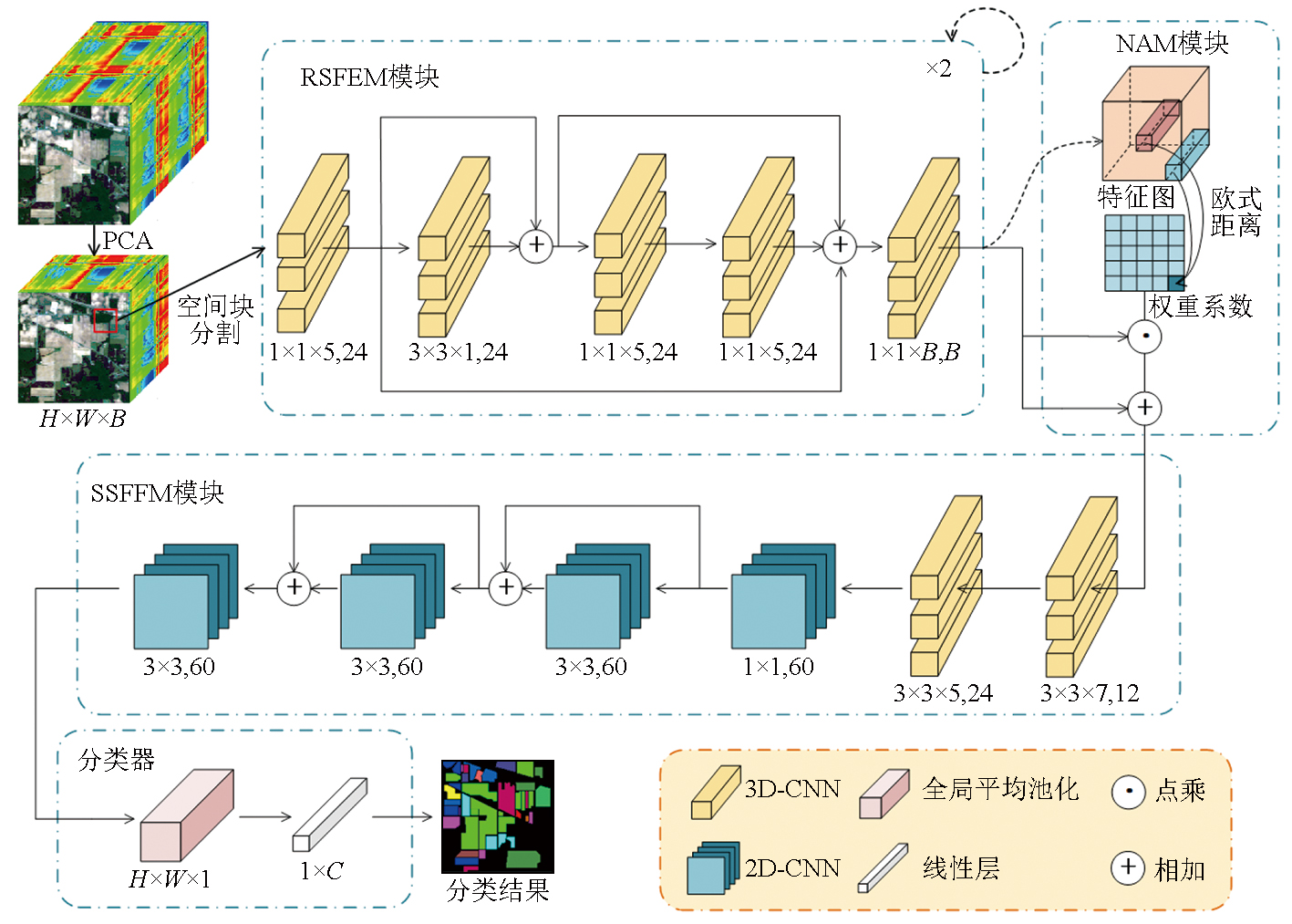
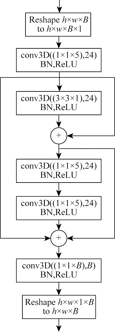
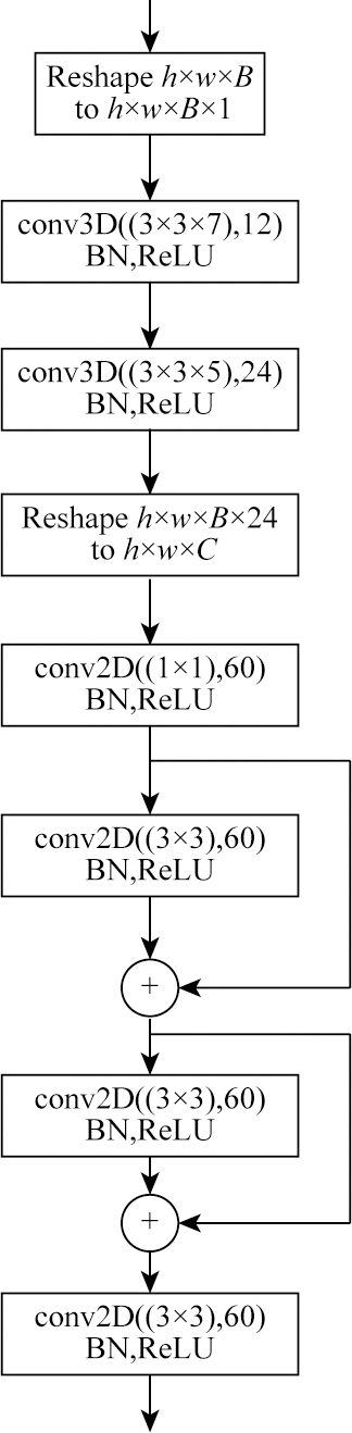
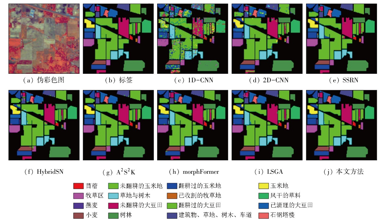
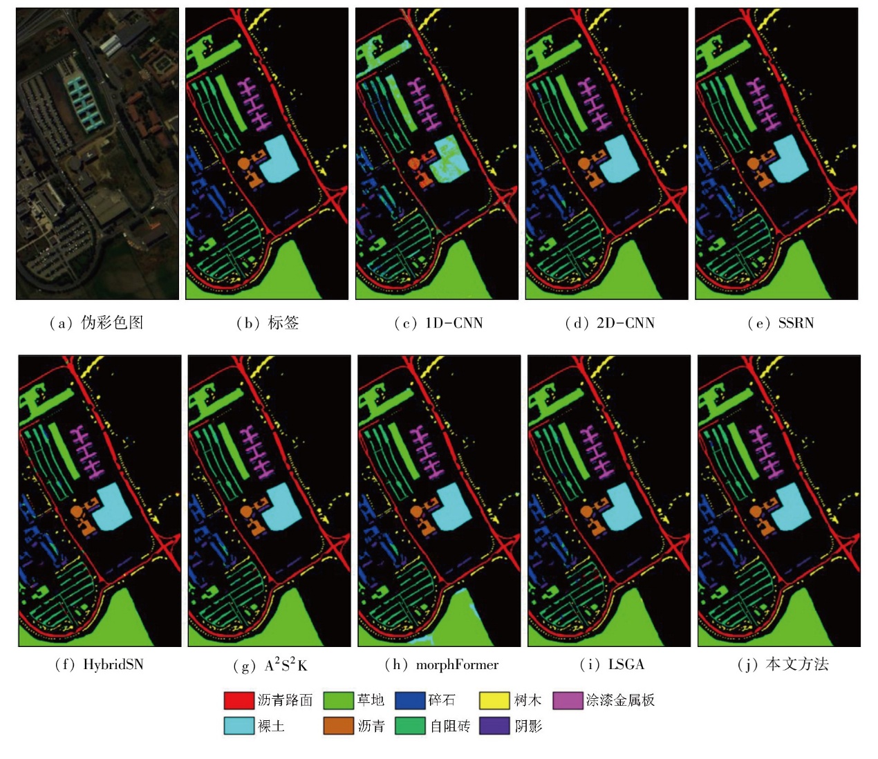
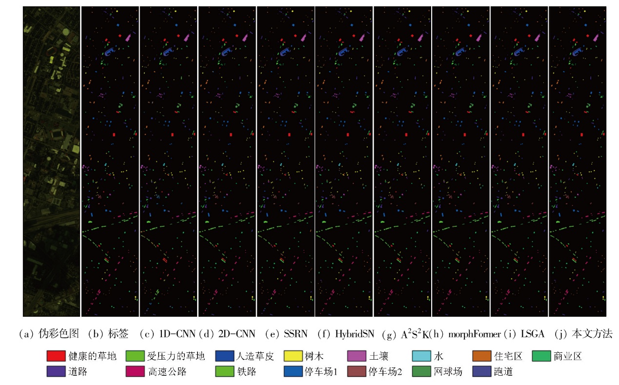
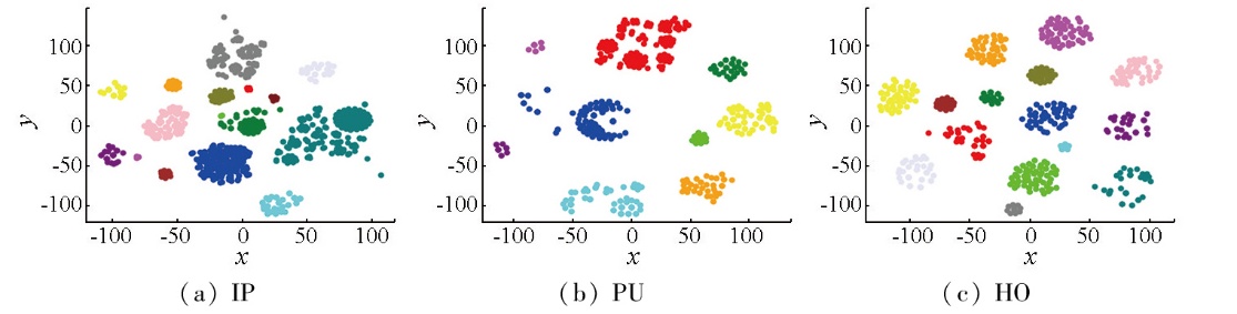
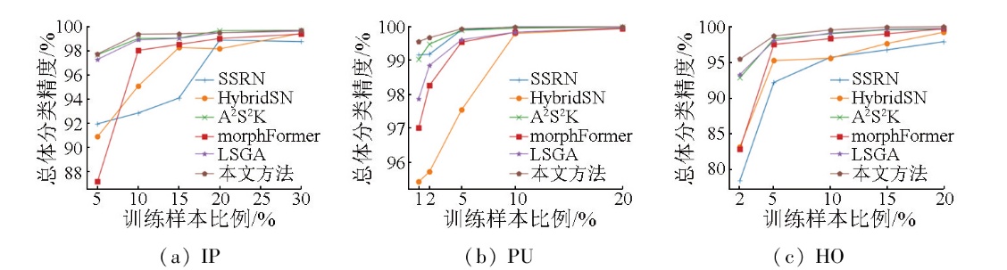
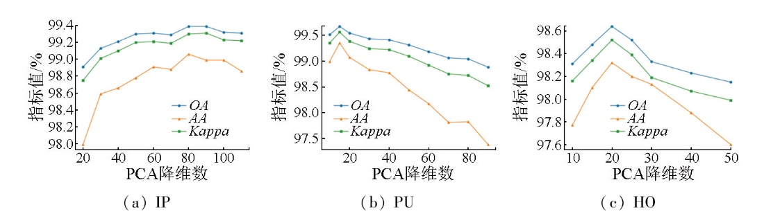
Abstract Hyperspectral remote sensing image classification has attracted widespread attention,yet the performance of classification methods remains greatly limited by challenges such as spectral variability (same object with different spectra),spectral confusion (different objects with similar spectra),and limited availability of training samples. To fully exploit the spatial-spectral features of hyperspectral images,this study proposed an improved network integrating residual convolution and neighborhood attention mechanisms. The proposed method consists of:(1) a residual-based spectral feature extraction module combining residual connections and a 3D convolutional neural network (3D-CNN);(2) a spatial-spectral feature fusion module using mixed convolutions;and (3) a neighborhood attention module designed to enhance the model's ability to focus on homogeneous regions. Experiments were conducted on three public hyperspectral datasets-Indian Pines,Pavia University,and Houston 2013. The results demonstrate that the proposed method achieves higher classification accuracy compared to recent state-of-the-art approaches. Using less than 10% of the samples for training,it attains overall accuracies of 99.39%,99.67%,and 98.64%,respectively,confirming its capability for high-accuracy classification under small-sample conditions.
|
| Keywords
hyperspectral image classification
convolutional neural network
residual connection
neighborhood attention
|
|
|
|
Issue Date: 28 October 2025
|
|
|
| [1] |
张涛, 王彬沣, 付莹, 等. 基于深度学习的光谱图像超分辨率综述[J]. 中国图象图形学报, 2024, 29(8):2113-2136.
|
| [1] |
Zhang T, Wang B F, Fu Y, et al. Deep learning-based spectral image super-resolution:A survey[J]. Journal of Image and Graphics, 2024, 29(8):2113-2136.
|
| [2] |
马晓瑞, 哈林, 谌敦斌, 等. 融合特征优化的跨数据集高光谱图像分类[J]. 中国图象图形学报, 2024, 29(8):2175-2187.
|
| [2] |
Ma X R, Ha L, Shen D B, et al. Cross-dataset hyperspectral image classification based on fusion feature optimization[J]. Journal of Image and Graphics, 2024, 29(8):2175-2187.
|
| [3] |
袁静文, 武辰, 杜博, 等. 高分五号高光谱遥感影像的城市土地利用景观格局分析[J]. 遥感学报, 2020, 24(4):465-478.
|
| [3] |
Yuan J W, Wu C, Du B, et al. Analysis of landscape pattern on urban land use based on GF-5 hyperspectral data[J]. Journal of Remote Sensing, 2020, 24(4):465-478.
|
| [4] |
王书伟, 席磊, 邱霜, 等. 高光谱遥感森林资源监测原理与应用[J]. 安徽农业科学, 2023, 51(15):111-114,197.
|
| [4] |
Wang S W, Xi L, Qiu S, et al. Principle and application of hyperspectral remote sensing forest resource monitoring[J]. Journal of Anhui Agricultural Sciences, 2023, 51(15):111-114,197.
|
| [5] |
杨燕杰. 基于高光谱的高海拔地区矿物信息提取与分析[J]. 世界核地质科学, 2023, 40(4):1020-1028.
|
| [5] |
Yang Y J. The alteration mineral information extraction and analysis of hyperspectral data in high-altitude area[J]. World Nuclear Geoscience, 2023, 40(4):1020-1028.
|
| [6] |
吕欢欢, 张峻通, 张辉. 多尺度特征与双注意力机制的高光谱影像分类[J]. 光电子·激光, 2024, 35(2):143-154.
|
| [6] |
Lyu H H, Zhang J T, Zhang H. Multi-scale feature and dual-attention mechanism for hyperspectral image classification[J]. Journal of Optoelectronics·Laser, 2024, 35(2):143-154.
|
| [7] |
Chen Y, Lin Z, Zhao X, et al. Deep learning-based classification of hyperspectral data[J]. IEEE Journal of Selected Topics in Applied Earth Observations and Remote Sensing, 2014, 7(6):2094-2107.
|
| [8] |
Liu Q, Zhou F, Hang R, et al. Bidirectional-convolutional LSTM based spectral-spatial feature learning for hyperspectral image classification[J]. Remote Sensing, 2017, 9(12):1330.
|
| [9] |
Mou L, Ghamisi P, Zhu X X. Deep recurrent neural networks for hyperspectral image classification[J]. IEEE Transactions on Geoscience and Remote Sensing, 2017, 55(7):3639-3655.
|
| [10] |
He K, Zhang X, Ren S, et al. Deep residual learning for image recognition[C]//2016 IEEE Conference on Computer Vision and Pattern Recognition (CVPR). IEEE, 2016:770-778.
|
| [11] |
Ren S, He K, Girshick R, et al. Faster R-CNN:Towards real-time object detection with region proposal networks[J]. IEEE Transactions on Pattern Analysis and Machine Intelligence, 2017, 39(6):1137-1149.
|
| [12] |
Shelhamer E, Long J, Darrell T. Fully convolutional networks for semantic segmentation[C]// IEEE Transactions on Pattern Analysis and Machine Intelligence. IEEE,2017:640-651.
|
| [13] |
Hu W, Huang Y, Wei L, et al. Deep convolutional neural networks for hyperspectral image classification[J]. Journal of Sensors, 2015, 2015(1):258619.
|
| [14] |
Makantasis K, Karantzalos K, Doulamis A, et al. Deep supervised learning for hyperspectral data classification through convolutional neural networks[C]//2015 IEEE International Geoscience and Remote Sensing Symposium (IGARSS). IEEE, 2015:4959-4962.
|
| [15] |
Zhu M, Jiao L, Liu F, et al. Residual spectral-spatial attention network for hyperspectral image classification[J]. IEEE Transactions on Geoscience and Remote Sensing, 2021, 59(1):449-462.
|
| [16] |
Kang X, Zhuo B, Duan P. Dual-path network-based hyperspectral image classification[J]. IEEE Geoscience and Remote Sensing Letters, 2019, 16(3):447-451.
doi: 10.1109/LGRS.2018.2873476
|
| [17] |
Hamida A B, Benoit A, Lambert P, et al. 3-D deep learning approach for remote sensing image classification[J]. IEEE Transactions on Geoscience and Remote Sensing, 2018, 56(8):4420-4434.
|
| [18] |
Zhong Z, Li J, Luo Z, et al. Spectral-spatial residual network for hyperspectral image classification:A 3-D deep learning framework[J]. IEEE Transactions on Geoscience and Remote Sensing, 2018, 56(2):847-858.
|
| [19] |
郑宗生, 王政翰, 王振华, 等. 改进3D-Octave卷积的高光谱图像分类方法[J]. 自然资源遥感, 2024, 36(4):82-91.doi:10.6046/zrzyyg.2023171.
|
| [19] |
Zheng Z S, Wang Z H, Wang Z H, et al. Improved 3D-Octave convolutional hyperspectral image classification method[J]. Remote Sensing for Natural Resources, 2024, 36(4):82-91.doi:10.6046/zrzyyg.2023171.
|
| [20] |
Roy S K, Krishna G, Dubey S R, et al. HybridSN:Exploring 3-D-2-D CNN feature hierarchy for hyperspectral image classification[J]. IEEE Geoscience and Remote Sensing Letters, 2020, 17(2):277-281.
|
| [21] |
Roy S K, Manna S, Song T, et al. Attention-based adaptive spectral-spatial kernel ResNet for hyperspectral image classification[J]. IEEE Transactions on Geoscience and Remote Sensing, 2021, 59(9):7831-7843.
|
| [22] |
Dosovitskiy A, Beyer L, Kolesnikov A, et al. An image is worth 16x16 words:Transformers for image recognition at scale[J/OL]. arXiv, 2020. https://arxiv.org/abs/2010.11929.
url: https://arxiv.org/abs/2010.11929
|
| [23] |
Roy S K, Deria A, Shah C, et al. Spectral-spatial morphological attention Transformer for hyperspectral image classification[J]. IEEE Transactions on Geoscience and Remote Sensing, 2023, 61:5503615.
|
| [24] |
Chen N, Fang L, Xia Y, et al. Spectral query spatial:Revisiting the role of center pixel in transformer for hyperspectral image classification[J]. IEEE Transactions on Geoscience and Remote Sensing, 2024, 62:5402714.
|
| [25] |
Ma C, Wan M, Wu J, et al. Light self-Gaussian-attention vision Transformer for hyperspectral image classification[J]. IEEE Transactions on Instrumentation and Measurement, 2023, 72:5015712.
|
| [26] |
D’Ascoli S, Touvron H, et al. ConViT:Improving vision Transfor-mers with soft convolutional inductive biases[C]//International conference on machine learning. PMLR,2021:2286-2296.
|
| [27] |
Gao H, Chen Z, Xu F. Adaptive spectral-spatial feature fusion network for hyperspectral image classification using limited training samples[J]. International Journal of Applied Earth Observation and Geoinformation, 2022, 107:102687.
|
| [28] |
Zhao Z, Hu D, Wang H, et al. Convolutional Transformer network for hyperspectral image classification[J]. IEEE Geoscience and Remote Sensing Letters, 2022, 19:6009005.
|
| [29] |
Debes C, Merentitis A, Heremans R, et al. Hyperspectral and LiDAR data fusion:Outcome of the 2013 GRSS data fusion contest[J]. IEEE Journal of Selected Topics in Applied Earth Observations and Remote Sensing, 2014, 7(6):2405-2418.
|
| [30] |
Zhang L, Zhang L, Du B. Deep learning for remote sensing data:A technical tutorial on the state of the art[J]. IEEE Geoscience and Remote Sensing Magazine, 2016, 4(2):22-40.
|
|
Viewed |
|
|
|
Full text
|
|
|
|
|
Abstract
|
|
|
|
|
Cited |
|
|
|
|
| |
Shared |
|
|
|
|
| |
Discussed |
|
|
|
|
 2025,
Vol. 37
2025,
Vol. 37