|
|
 |
|

|
|
|
Remote sensing-based information extraction of the geological landscape in the Zhada earth forest distribution area |
YE Qiang1( ), WANG Hong2, YANG Zhaoying3, JIANG Xiao3(), NYIMA Ciren1, LU Wenjia3 ), WANG Hong2, YANG Zhaoying3, JIANG Xiao3(), NYIMA Ciren1, LU Wenjia3 |
1. Xizang Institute of Geological Survey, Lhasa 850000, China
2. Information Center of Ministry of Natural Resources, Beijing 100036, China
3. China Aero Geophysical Survey and Remote Sensing Center for Natural Resources, Beijing 100083, China |
|
|
|
|
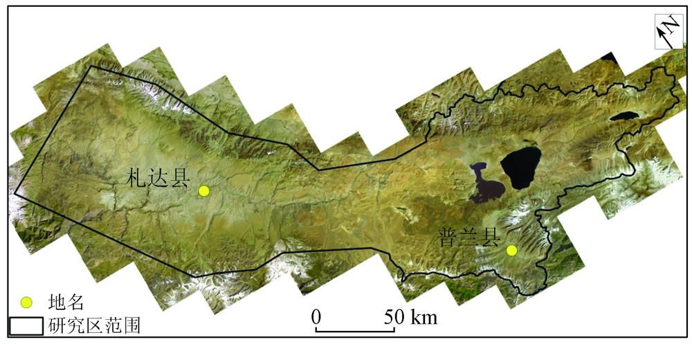
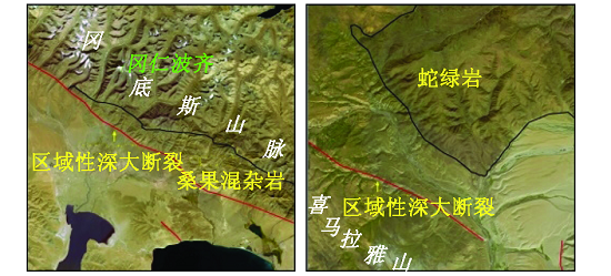
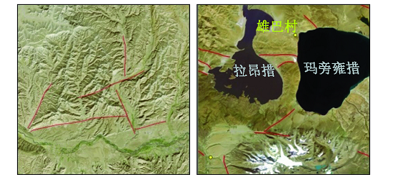
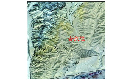
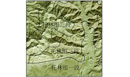
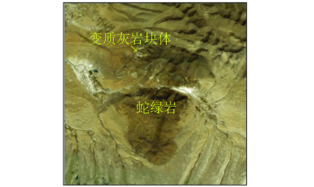
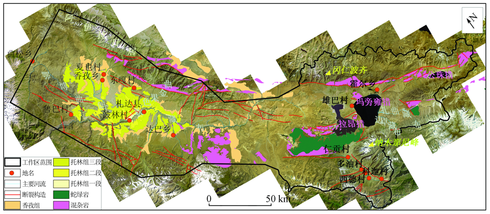
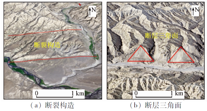
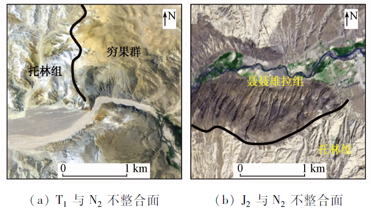
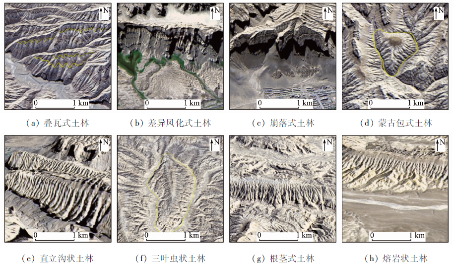
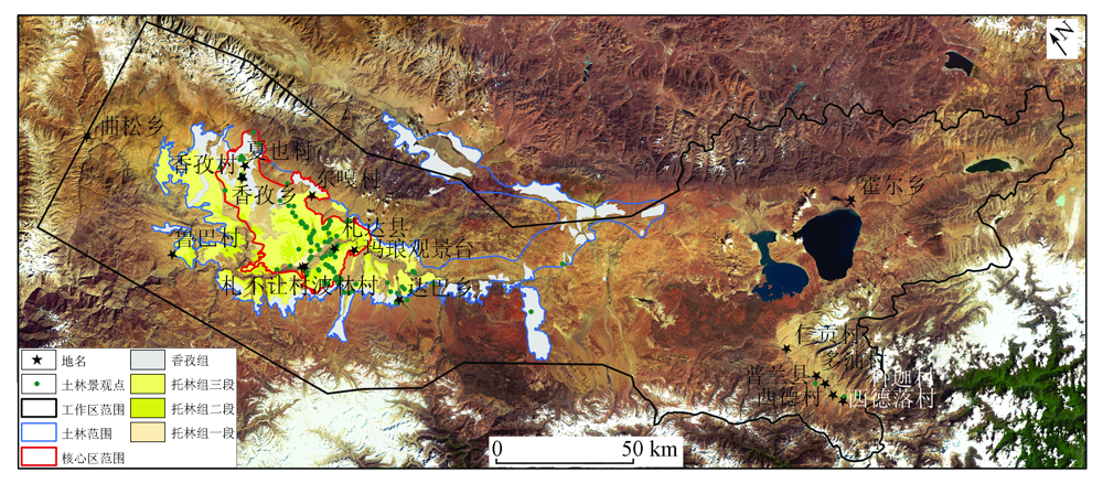
Abstract The Zhada earth forest, located in Zhada and Pulan Counties, Tibet, is composed primarily of weakly consolidated to semi-consolidated clastics s of the Tuolin and Xiangzi formations. This area forms a unique geological landscape consisting of peaks and ravines due to the long-term erosion by rivers and rain. To further explore the tourism resources in the Zhada earth forest distribution area and fully reveal the scientific and aesthetic values of the study area, this study carried out the geological interpretation of the study area mainly based on the GF-1 satellite remote sensing images, with the interpretation focusing on the Xiangzi and Tuolin formations constituting the earth forest landscape, as well as ophiolites and tectonic melanges reflecting plate subduction. Based on the interpretation results and the 3D interpretation environment of the Aerial Geophysical Remote Sensing Multivariate Data Processing and Product Display Platform, this study extracted information on typical geological landscapes in the study area, including earth forests, various rocks, and fault structures. The remote sensing technology helped delineate the distribution range of the earth forest more accurately. The 3D display platform enabled the more vivid display of the geological relics that represented the dramatic changes in the regional evolution history, such as earth forests, oceanic crust remnants, and unconformities. The application of modern information technology can provide strong support for the landscape planning of the Zhada Earth Forest National Geopark.
|
| Keywords
Zhada earth forest
geological landscape
remote sensing
|
|
|
|
Issue Date: 20 March 2023
|
|
|
| [1] |
罗鹏辉, 张世涛, 田宜敏, 等. 土林地貌分类研究[J]. 地球学报, 2020, 41(4):575-582.
|
| [1] |
Luo P H, Zhang S T, Tian Y M, et al. The geomorphologic classification of earth forest landform[J]. Acta Geoscientica Sinica, 2020, 41(4):575-582.
|
| [2] |
May F E, Traverse A. Palynology of the Dakota sandstone (middle cretaceous)near Bryce Canyon National Park,Southern Utah[J]. Geoscience and Man, 1973, 7(1):57-64.
doi: 10.1080/00721395.1973.9989733
url: http://www.tandfonline.com/doi/abs/10.1080/00721395.1973.9989733
|
| [3] |
Hermelin M. La Playa badlands and their earth pillars[C]// Springer International Publishing, 2016.
|
| [4] |
孟宪刚, 朱大岗, 邵昭刚, 等. 一种新的地质地貌景观类型——西藏札达盆地古格地貌的特征与成因初探[J]. 地质通报, 2006, 25(1-2):295-301.
|
| [4] |
Meng X G, Zhu D G, Shao Z G, et al. A new type of geological-geomorphological landscape:Discussion of the Guge forest geomorphological features and its origin in the Zanda Basin,Ngari,Tibet,China[J]. Geological Bulletin of China, 2006, 25(1-2): 295-301.
|
| [5] |
赵学艺. 大同土林景区主要自然景物——土林形成发展过程及安全保护[J]. 干旱资源与环境, 2012, 26(7):195-200.
|
| [5] |
Zhao X Y. Analysis on the development course of the earth-forest in Datong and its protection[J]. Journal of the Arid Land Resources and Environment, 2012, 26(7):195-200.
|
| [6] |
钱方, 凌小惠. 元谋土林成因及类型的初步研究[J]. 中国科学(B辑), 1989(4):412-418.
|
| [6] |
Qian F, Ling X H. A preliminary study on genetics and type for earth forest in Yuanmou basin Yuannan Province,China[J]. Science in China(series B), 1989(4):412-418.
|
| [7] |
王小群, 魏玉峰. 西昌黄联土林的成因初探[J]. 水土保持研究, 2007, 14(1):218-220.
|
| [7] |
Wang X Q, Wei Y F. The Preliminary analysis on formation mechanism of the earth forest of Xichang-Huanglian[J]. Research of Soil and Water Conservation, 2007, 14(1):218-220.
|
| [8] |
陈述云, 张建云. 元谋土林的形成条件及发育速率[J]. 云南地质, 1994, 13(4):383-391.
|
| [8] |
Chen S Y, Zhang J Y. Formation conditions and development rate of earth forest of Yuanmou[J]. Yunnan Geology, 1994, 13(4):383-391.
|
| [9] |
侯利锋, 刘建兵. 西藏札达土林地貌形成条件及演化过程[J]. 西部探矿工程, 2017, 2:65-68.
|
| [9] |
Hou L F, Liu J B. Forming condition and evolution process of earth forest landform in Zanda of Tibet[J]. West-China Exploration Engineering, 2017, 2:65-68.
|
| [10] |
朱仁鹏, 石晨霞. 对西藏札达土林国家地质公园旅游业发展的思考[J]. 安徽农业科学, 2011, 39(13):7900-7901,7922.
|
| [10] |
Zhu R P, Shi C X. Reflection on tourism development of Tibet Zhada Turin National Geopark[J]. Journal of Anhui Agricultural Sciences, 2011, 39(13):7900-7901,7922.
|
| [11] |
王行军, 王根厚, 李广栋, 等. 西藏西部札达县东北部帮果日-波库蛇绿岩带的发现及其地质意义[J]. 中国地质, 2013, 40(6):1749-1761.
|
| [11] |
Wang X J, Wang G H, Li G D, et al. The discovery of Banguori-Boku ophiolite belt in northeastern Zanda County of west Tibet and its geological significance[J]. Geology in China, 2013, 40(6):1749-1761.
|
| [12] |
古格其美多吉, 索朗仁青.西藏阿里地区生态旅游区划及分区开发策略[J]. 西藏研究, 2011, 5:99-107.
|
| [12] |
Guge Q M D J, Suolang R Q. The categories,planning and development of ecological tourist resources in Ngari area in Tibet[J]. Tibetan Studies, 2011, 5:99-107.
|
|
Viewed |
|
|
|
Full text
|
|
|
|
|
Abstract
|
|
|
|
|
Cited |
|
|
|
|
| |
Shared |
|
|
|
|
| |
Discussed |
|
|
|
|
 2023,
Vol. 35
2023,
Vol. 35