|
|
|
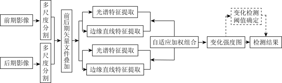
Abstract In view of the fact that the traditional change detection algorithm mainly depends on the spectral information and fails to effectively use image feature detection advantage, the authors put forward a multi-feature fusion of remote sensing image change detection algorithm. First, color histogram and edge histogram of gradient image object with multi-scale segmentation is statistically analyzed based on the calculation of each object. Then, the object color distance and edge linear characteristics distance between different periods are calculated by using the earth mover’s distance method; the adaptive weighted method is used to combine color distance and edge linear characteristics distance so as to construct object heterogeneity. Finally, the images change detection results are analyzed by using histogram curvature. The experimental results show that the method can fully fuse the color and edge line features and improve the accuracy of detection.
|
| Keywords
change detection
color histogram
linear gradient histogram
histogram distance
histogram curvature
|
|
|
|
Issue Date: 30 May 2018
|
|
|
| [1] |
魏立飞, 钟燕飞, 张良培 , 等. 遥感影像融合的自适应变化检测(英文)[J]. 遥感学报, 2010,14(6):1196-1211.
url: http://d.wanfangdata.com.cn/Periodical/ygxb201006010
|
| [1] |
Wei L F, Zhong Y F, Zhang L P , et al. Adaptive change method of remote sensing image fusion[J]. Journal of Remote Sensing, 2010,14(6):1196-1211.
|
| [2] |
Gong J Y, Sui H G, Sun K M , et al. Object-level change detection based on full-scale image segmentation and its application to Wenchuan Earthquake[J]. Science in China Series E:Technological Sciences, 2008,51(S2):110-122.
doi: 10.1007/s11431-008-6017-y
url: http://link.springer.com/10.1007/s11431-008-6017-y
|
| [3] |
Zhang G, Li Y, Li Z J . A new approach toward object-based change detection[J]. Science China Technological Sciences, 2010,53(S1):105-110.
doi: 10.1007/s11431-010-3215-1
url: http://link.springer.com/article/10.1007/s11431-010-3215-1
|
| [4] |
Bovolo F, Bruzzone L, Marconcini M . A novel approach to unsupervised change detection based on a semisupervised SVM and a similarity measure[J]. IEEE Transactions on Geoscience and Remote Sensing, 2008,46(7):2070-2082.
doi: 10.1109/TGRS.2008.916643
url: http://ieeexplore.ieee.org/document/4539638/
|
| [5] |
庄会富, 邓喀中, 范洪冬 . 纹理特征向量与最大化熵法相结合的SAR影像非监督变化检测[J]. 测绘学报, 2016,45(3):339-346.
url: http://www.cqvip.com/QK/90069X/201603/668414135.html
|
| [5] |
Zhuang H F, Deng K Z, Fan H D . SAR images unsupervised change detection based on combination of texture feature vector with maximum entropy principle[J]. Acta Geodaetica et Cartographica Sinica, 2016,45(3):339-346.
|
| [6] |
李松, 李亦秋, 安裕伦 . 基于变化检测的滑坡灾害自动识别[J].遥感信息, 2010(1):27-31.
doi: 10.3969/j.issn.1000-3177.2010.01.006
url: http://www.cqvip.com/Main/Detail.aspx?id=33394083
|
| [6] |
Li S, Li Y Q, An Y L . Automatic recognition of landslides based on change detection[J].Remote sensing Information, 2010(1):27-31.
|
| [7] |
钟家强, 王润生 . 基于自适应参数估计的多时相遥感图像变化检测[J]. 测绘学报, 2005,34(4):331-336.
|
| [7] |
Zhong J Q, Wang R S . Multitemporal remote sensing image change detection based on adaptive parameter estimation[J]. Acta Geodaetica et Cartographica Sinica, 2005,34(4):331-336.
|
| [8] |
刘臻, 宫鹏, 史培军 , 等. 基于相似度验证的自动变化探测研究[J]. 遥感学报, 2005,9(5):537-543.
doi: 10.3321/j.issn:1007-4619.2005.05.004
url: http://d.wanfangdata.com.cn/Periodical/ygxb200505004
|
| [8] |
Liu Z, Gong P, Shi P J , et al. Study on change detection automatically based on similarity calibration[J]. Journal of Remote Sensing, 2005,9(5):537-543.
|
| [9] |
李亮, 舒宁, 王凯 , 等. 融合多特征的遥感影像变化检测方法[J]. 测绘学报, 2014,43(9):945-953.
doi: 10.13485/j.cnki.11-2089.2014.0138
|
| [9] |
Li L, Shu N, Wang K , et al. Change detection method for remote sensing images based on multi-features fusion[J]. Acta Geodaetica et Cartographica Sinica, 2014,43(9):945-953.
|
| [10] |
魏立飞, 王海波 . 基于MSE模型的高分辨率遥感图像变化检测[J]. 光谱学与光谱分析, 2013,33(3):728-732.
url: http://www.opticsjournal.net/Articles/Abstract?aid=OJ130327000358hOkQnT
|
| [10] |
Wei L F, Wang H B . Change detection from high-resolution remote sensing image based on MSE model[J]. Spectroscopy and Spectral Analysis, 2013,33(3):728-732.
|
| [11] |
巫兆聪, 胡忠文, 张谦 , 等. 结合光谱、纹理与形状结构信息的遥感影像分割方法[J]. 测绘学报, 2013,42(1):44-50.
|
| [11] |
Wu Z C, Hu Z W, Zhang Q , et al. On combining spectral,textural and shape features for remote sensing image segmentation[J]. Acta Geodaetica et Cartographica Sinica, 2013,42(1):44-50.
|
| [12] |
陈云浩, 冯通, 史培军 , 等. 基于面向对象和规则的遥感影像分类研究[J]. 武汉大学学报(信息科学版), 2006,31(4):316-320.
doi: 10.3321/j.issn:1671-8860.2006.04.009
|
| [12] |
Chen Y H, Feng T, Shi P J , et al. Classification of remot sensing image based on object oriented and class rules[J]. Geomatics and Information Science of Wuhan University, 2006,31(4):316-320.
|
| [13] |
窦建军, 文俊, 刘重庆 . 基于颜色直方图的图像检索技术[J]. 红外与激光工程, 2005,34(1):84-88.
url: http://www.opticsjournal.net/Articles/Abstract?aid=OJ0604280007991w4z7C
|
| [13] |
Dou J J, Wen J, Liu C Q . Histogram-based color image retrieval[J]. Infrared and Laser Engineering, 2005,34(1):84-88.
|
| [14] |
Von Gioi R G,Jakubowicz J,Morel J M,et al.LSD:A line segment detector[J]. Image Processing on Line, 2012,2:35-55.
doi: 10.5201/ipol.2012.gjmr-lsd
url: http://www.ipol.im/?utm_source=doi
|
| [15] |
韩华, 曹伟, 龚涛 . 目标再确认中基于推土机距离的关联度建立[J]. 华中科技大学学报(自然科学版), 2015,43(s1):435-439.
doi: 10.13245/j.hust.15S1104
url: http://d.wanfangdata.com.cn/Periodical/hzlgdxxb2015z1104
|
| [15] |
Han H, Cao W, Gong T . The establishment of correlative degree in target re-identification based on earth mover’s distance[J]. Huazhong University of Science and Technology(Natural Science Edition), 2015,43(s1):435-439.
|
| [16] |
Wang A P, Wang S G, Lucieer A . Segmentation of multispectral high-resolution satellite imagery based on integrated feature distributions[J]. International Journal of Remote Sensing, 2010,31(6):1471-1483.
doi: 10.1080/01431160903475308
url: http://www.tandfonline.com/doi/abs/10.1080/01431160903475308
|
|
Viewed |
|
|
|
Full text
|
|
|
|
|
Abstract
|
|
|
|
|
Cited |
|
|
|
|
| |
Shared |
|
|
|
|
| |
Discussed |
|
|
|
|
 2018,
Vol. 30
2018,
Vol. 30
 ), Jianlei LI2, Huabin WANG1, Huachao YANG2