|
|
 |
|

|
|
|
Classification of wetland plant communities in the Yellow River Delta based on GEE and multisource remote sensing data |
ZHANG Nianqiu1,2( ), MAO Dehua1,3(), FENG Kaidong1,2, ZHEN Jianing1, XIANG Hengxing1, REN Yongxing1 ), MAO Dehua1,3(), FENG Kaidong1,2, ZHEN Jianing1, XIANG Hengxing1, REN Yongxing1 |
1. Northeast Institute of Geography and Agroecology, Chinese Academy of Sciences, Changchun 130102, China
2. University of Chinese Academy of Sciences, Beijing 100049, China
3. Key Laboratory of Wetland Ecology and Environment, Northeast Institute of Geography and Agroecology, CAS, Changchun 130102, China |
|
|
|
|
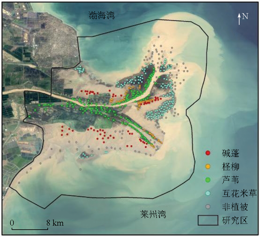
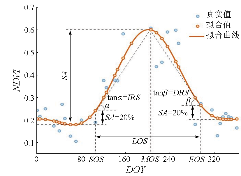
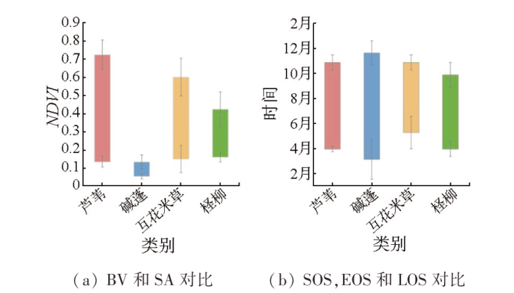
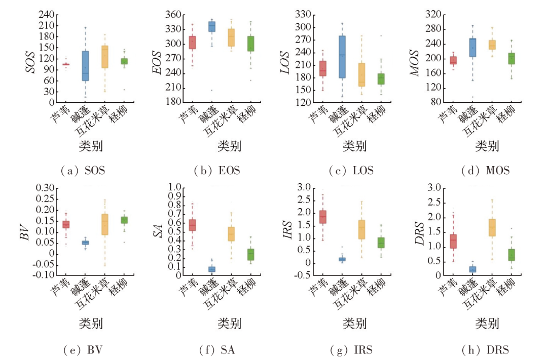
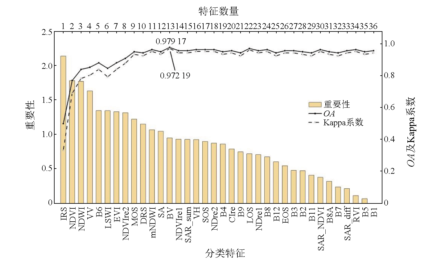
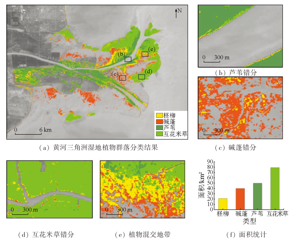
Abstract Accurately identifying plant communities in coastal wetlands is critical for strengthening the ecological quality monitoring and enhancing the ecosystem functions of coastal wetlands. With the Yellow River Delta as the study area, this study constructed a feature vector set including phenological, optical, red-edge, and radar features based on Sentinel-1/2 image data using the Google Earth Engine (GEE) platform. It classified the wetland plant communities in the Yellow River Delta in 2021 using the random forest algorithm. Moreover, it explored the effects of phenological features in classification. The results reveal an overall classification accuracy of 97.91 % and a Kappa coefficient of 0.97. In 2021, the distribution areas of Phragmites australis, Suaeda glauca, Spartina alterniflora, and Tamarix chinensis were 49.91 km2, 39.91 km2, 79.36 km2, and 20.86 km2, respectively. The phenological features of typical plant communities in the Yellow River Delta wetlands were effectively extracted based on the normalized difference vegetation index (NDVI) time-series fitting curves. The highly distinguishable features included the maximum value date, base value, growth amplitude, beginning-of-season growth rate, and end-of-season decline rate. Compared to other feature variables, phenological features contributed more significantly to the overall classification accuracy, suggesting their prominent role in classification. The results of this study provide a methodological reference and scientific basis for the plant community monitoring and ecological conservation of coastal wetlands in the Yellow River Delta.
|
| Keywords
GEE
Sentinel-1/2 images
phenological features
wetland plant community
Yellow River Delta
|
|
|
|
Issue Date: 09 May 2025
|
|
|
| [1] |
Scott D B, Frail J, Mudie P J. Coastal wetlands of the world[M]. Cambridge: Cambridge University Press, 2014:17.
|
| [2] |
Song S, Wu Z F, Wang Y F, et al. Mapping the rapid decline of the intertidal wetlands of China over the past half century based on remote sensing[J]. Frontiers in Earth Science, 2020:8.
|
| [3] |
Murray N J, Clemens R S, Phinn S R, et al. Tracking the rapid loss of tidal wetlands in the Yellow Sea[J]. Frontiers in Ecology and the Environment, 2014, 12(5):267-272.
|
| [4] |
Qiu Z Q, Mao D H, Feng K D, et al. High-resolution mapping changes in the invasion of Spartina alterniflora in the Yellow River Delta[J]. IEEE Journal of Selected Topics in Applied Earth Observations and Remote Sensing, 2022, 15:6445-6455.
|
| [5] |
马喜君, 陆兆华, 林涛. 盐城海滨湿地生态风险评价[J]. 海洋环境科学, 2010, 29(4):599-602.
|
| [5] |
Ma X J, Lu Z H, Lin T. Ecological risk assessment of Yancheng Coastal Wetland[J]. Marine Environmental Science, 2010, 29(4):599-602.
|
| [6] |
许婕, 刘加珍, 张天举, 等. 黄河口湿地柽柳灌丛土壤盐渍化特征[J]. 生态学报, 2022, 42(17):7118-7127.
|
| [6] |
Xu J, Liu J Z, Zhang T J, et al. Soil salinization characteristics under the crown of Tamarix chinensis in the wetland of the Yellow River Estuary[J]. Acta Ecologica Sinica, 2022, 42(17):7118-7127.
|
| [7] |
刘瑞清, 李加林, 孙超, 等. 基于Sentinel-2遥感时间序列植被物候特征的盐城滨海湿地植被分类[J]. 地理学报, 2021, 76(7):1680-1692.
doi: 10.11821/dlxb202107008
|
| [7] |
Liu R Q, Li J L, Sun C, et al. Classification of Yancheng coastal wetland vegetation based on vegetation phenological characteristics derived from Sentinel-2 time-series[J]. Acta Geographica Sinica, 2021, 76(7):1680-1692.
doi: 10.11821/dlxb202107008
|
| [8] |
Chen B Q, Xiao X M, Li X P, et al. A mangrove forest map of China in 2015:Analysis of time series Landsat 7/8 and Sentinel-1A imagery in Google Earth Engine cloud computing platform[J]. ISPRS Journal of Photogrammetry and Remote Sensing, 2017, 131:104-120.
|
| [9] |
Zhao Y X, Mao D H, Zhang D Y, et al. Mapping Phragmites australis aboveground biomass in the momoge wetland ramsar site based on sentinel-1/2 images[J]. Remote Sensing, 2022, 14:694.
|
| [10] |
许青云, 李莹, 谭靖, 等. 基于高分六号卫星数据的红树林提取方法[J]. 自然资源遥感, 2023, 35(1):41-48.doi:10.6046/zrzyyg.2022048.
|
| [10] |
Xu Q Y, Li Y, Tan J, et al. Information extraction method of mangrove forests based on GF-6 data[J]. Remote Sensing for Natural Resources, 2023, 35(1):41-48.doi:10.6046/zrzyyg.2022048.
|
| [11] |
Zhang C, Gong Z N, Qiu H C, et al. Mapping typical salt-marsh species in the Yellow River Delta wetland supported by temporal-spatial-spectral multidimensional features[J]. Science of the Total Environment, 2021, 783:147061.
|
| [12] |
Zhu W Q, Ren G B, Wang J P, et al. Monitoring the invasive plant Spartina alterniflora in Jiangsu coastal wetland using MRCNN and long-time series landsat data[J]. Remote Sensing, 2022, 14(11):2630.
|
| [13] |
宁晓刚, 常文涛, 王浩, 等. 联合GEE与多源遥感数据的黑龙江流域沼泽湿地信息提取[J]. 遥感学报, 2022, 26(2):386-396.
|
| [13] |
Ning X G, Chang W T, Wang H, et al. Extraction of marsh wetland in Heilongjiang basin based on GEE and multi-source remote sensing data[J]. National Remote Sensing Bulletin, 2022, 26(2):386-396.
|
| [14] |
Li H Y, Mao D H, Wang Z M, et al. Invasion of spartina alterniflora in the coastal zone of mainland China:Control achievements from 2015 to 2020 towards the Sustainable Development Goals[J]. Journal of Environmental Management, 2022, 323:116242.
|
| [15] |
张磊, 宫兆宁, 王启为, 等. Sentinel-2影像多特征优选的黄河三角洲湿地信息提取[J]. 遥感学报, 2019, 23(2):313-326.
|
| [15] |
Zhang L, Gong Z N, Wang Q W, et al. Wetland mapping of Yellow River Delta wetlands based on multi-feature optimization of Sentinel-2 images[J]. National Remote Sensing Bulletin, 2019, 23(2):313-326.
|
| [16] |
Gong Z N, Zhang C, Zhang L, et al. Assessing spatiotemporal characteristics of native and invasive species with multi-temporal remote sensing images in the Yellow River Delta,China[J]. Land Degradation & Development, 2021, 32(3):1338-1352.
|
| [17] |
Han X, Wang Y, Ke Y, et al. Phenological heterogeneities of invasive Spartina alterniflora salt marshes revealed by high-spatial-resolution satellite imagery[J]. Ecological Indicators, 2022, 144:109492.
|
| [18] |
Friedl M A, Sulla-Menashe D, Tan B, et al. MODIS Collection 5 global land cover:Algorithm refinements and characterization of new datasets[J]. Remote Sensing of Environment, 2010, 114(1):168-182.
|
| [19] |
Wang T, Zhang H S, Lin H, et al. Textural-spectral feature-based species classification of mangroves in Mai Po Nature Reserve from Worldview-3 imagery[J]. Remote Sensing, 2016, 8(1):24.
|
| [20] |
陈健, 李虎, 刘玉锋, 等. 基于Sentinel-2数据多特征优选的农作物遥感识别研究[J]. 自然资源遥感, 2023, 35(4):292-300.doi:10.6046/zrzyyg.2022272.
|
| [20] |
Chen J, Li H, Liu Y F, et al. Crops identification based on Sentinel-2 data with multi-feature optimization[J]. Remote Sensing for Natural Resources, 2023, 35(4):292-300.doi:10.6046/zrzyyg.2022272.
|
| [21] |
Li A, Song K, Chen S, et al. Mapping African wetlands for 2020 using multiple spectral,geo-ecological features and Google Earth Engine[J]. ISPRS Journal of Photogrammetry and Remote Sensing, 2022, 193:252-268.
|
| [22] |
Tian J, Wang L, Yin D, et al. Development of spectral-phenological features for deep learning to understand Spartina alterniflora invasion[J]. Remote Sensing of Environment, 2020, 242:111745.
|
| [23] |
Zhang X, Xiao X, Wang X, et al. Quantifying expansion and removal of Spartina alterniflora on Chongming Island,China,using time series Landsat images during 1995-2018[J]. Remote Sensing of Environment, 2020, 247:111916.
|
| [24] |
Sun C, Li J, Liu Y, et al. Plant species classification in salt marshes using phenological parameters derived from Sentinel-2 pixel-differential time-series[J]. Remote Sensing of Environment, 2021, 256:112320.
|
| [25] |
李恒凯, 王利娟, 肖松松. 基于多源数据的南方丘陵山地土地利用随机森林分类[J]. 农业工程学报, 2021, 37(7):244-251.
|
| [25] |
Li H K, Wang L J, Xiao S S. Random forest classification of land use in hilly and mountaineous areas of Southern China using multi-source remote sensing data[J]. Transactions of the Chinese Society of Agricultural Engineering, 2021, 37(7):244-251.
|
| [26] |
Ai J, Gao W, Gao Z, et al. Phenology-based Spartina alterniflora mapping in coastal wetland of the Yangtze Estuary using time series of GaoFen satellite No.1 wide field of view imagery[J]. Journal of Applied Remote Sensing, 2017, 11:026020.
|
| [27] |
Feng K, Mao D, Qiu Z, et al. Can time-series Sentinel images be used to properly identify wetland plant communities?[J]. GIScience & Remote Sensing, 2022, 59(1):2202-2216.
|
| [28] |
薛朝辉, 钱思羽. 融合Landsat 8与Sentinel-2数据的红树林物候信息提取与分类[J]. 遥感学报, 2022, 26(6):1121-1142.
|
| [28] |
Xue Z H, Qian S Y. Fusion of Landsat 8 and Sentinel-2 data for mangrove phenology information extraction and classification[J]. National Remote Sensing Bulletin, 2022, 26(6):1121-1142.
|
|
Viewed |
|
|
|
Full text
|
|
|
|
|
Abstract
|
|
|
|
|
Cited |
|
|
|
|
| |
Shared |
|
|
|
|
| |
Discussed |
|
|
|
|
 2025,
Vol. 37
2025,
Vol. 37