|
|
|
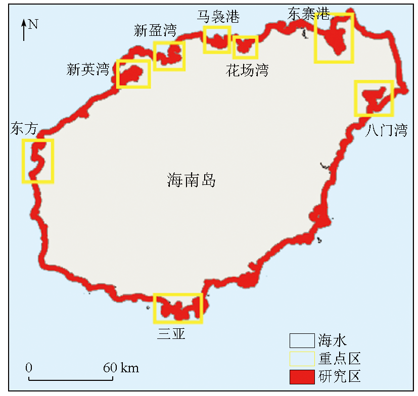
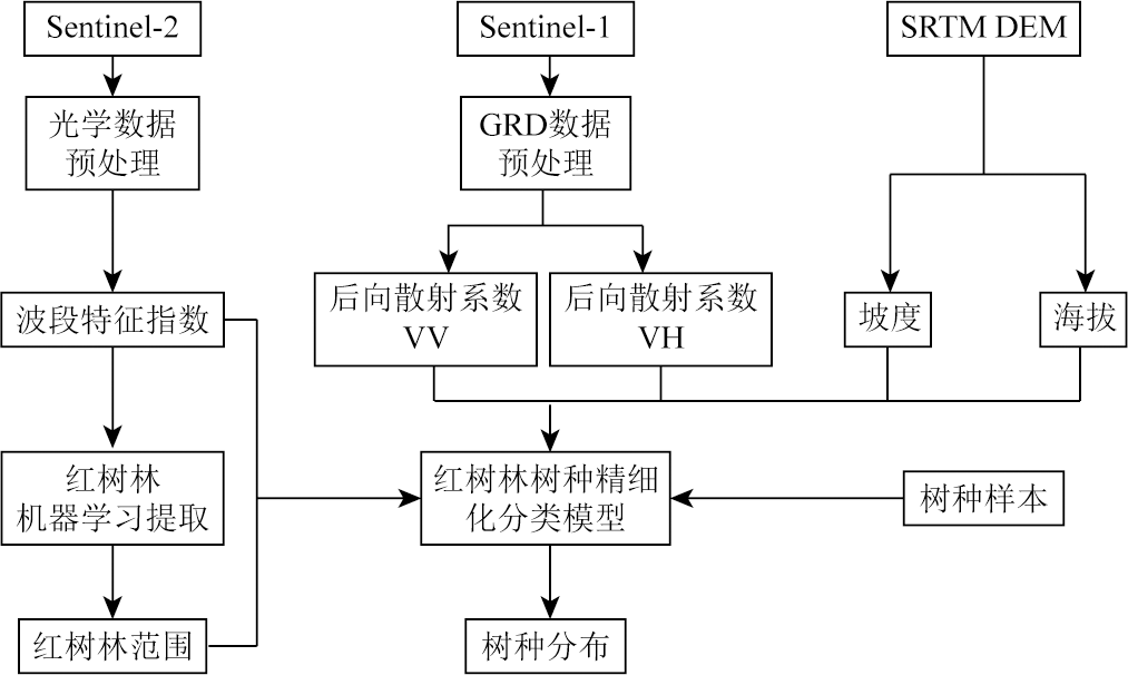
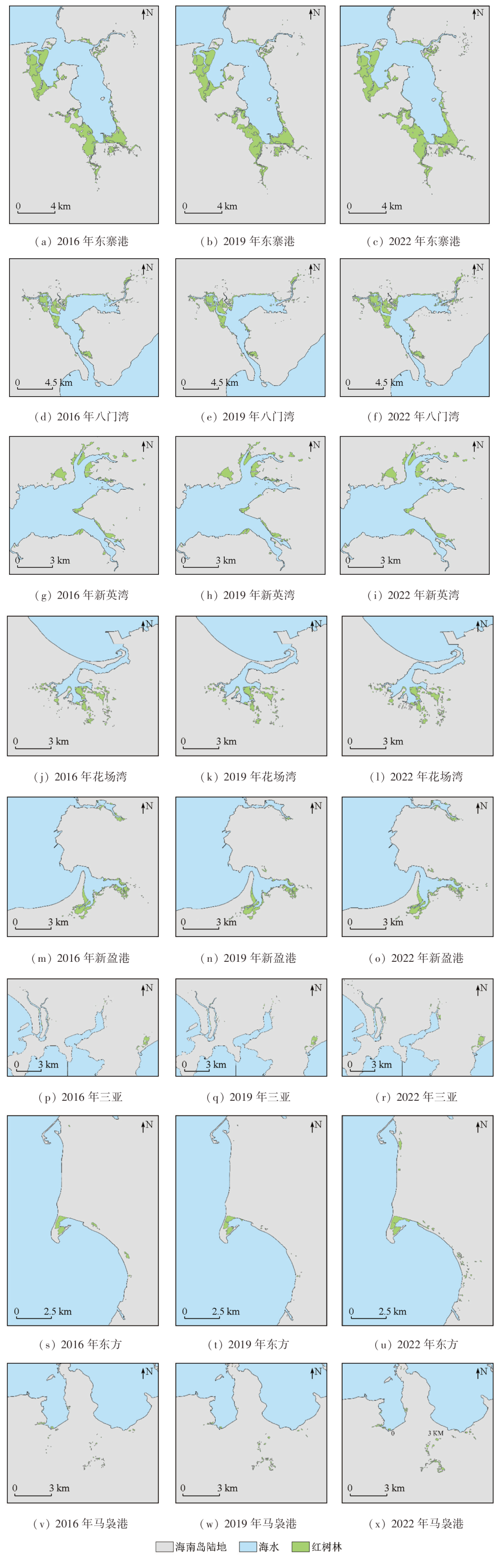
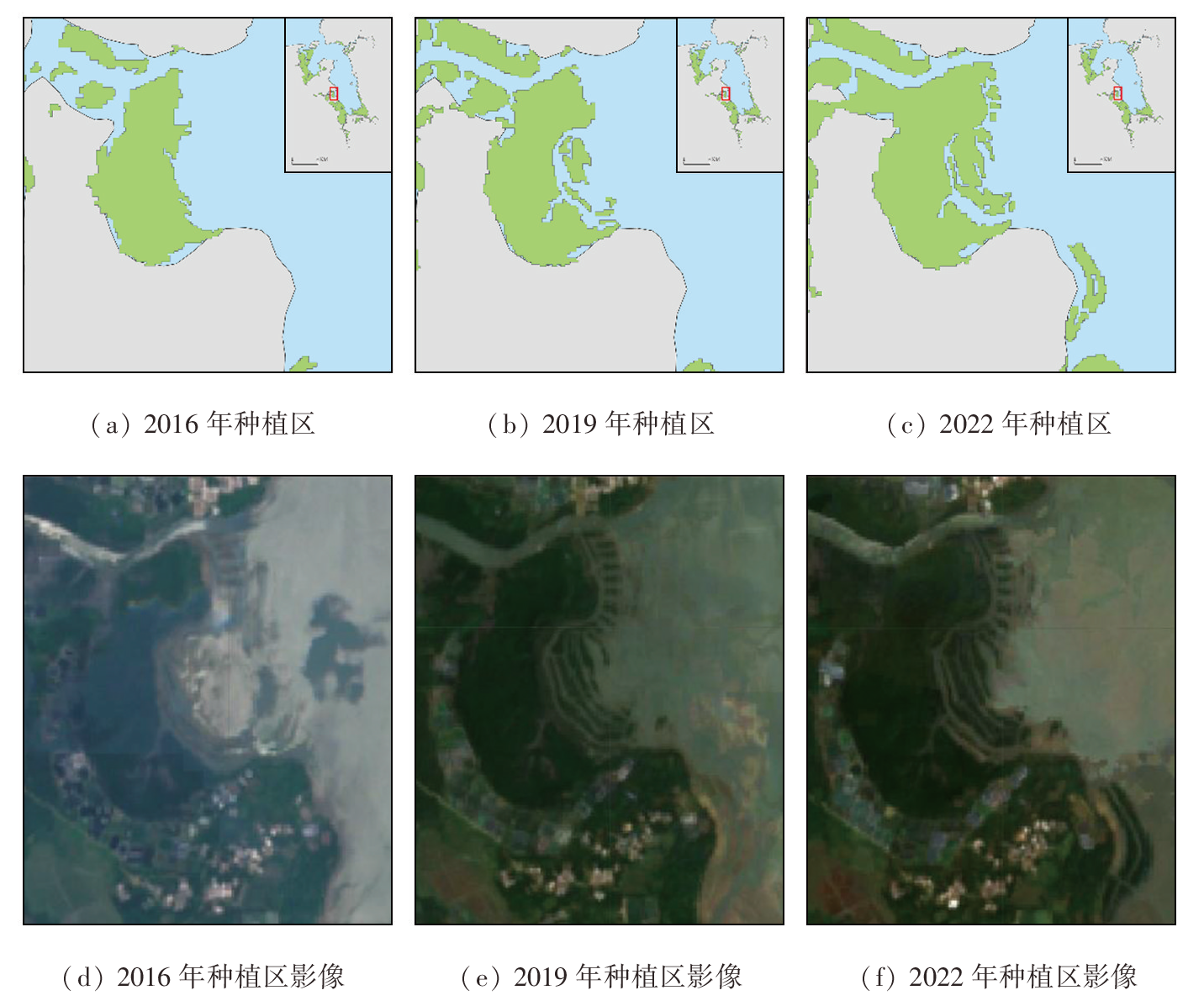
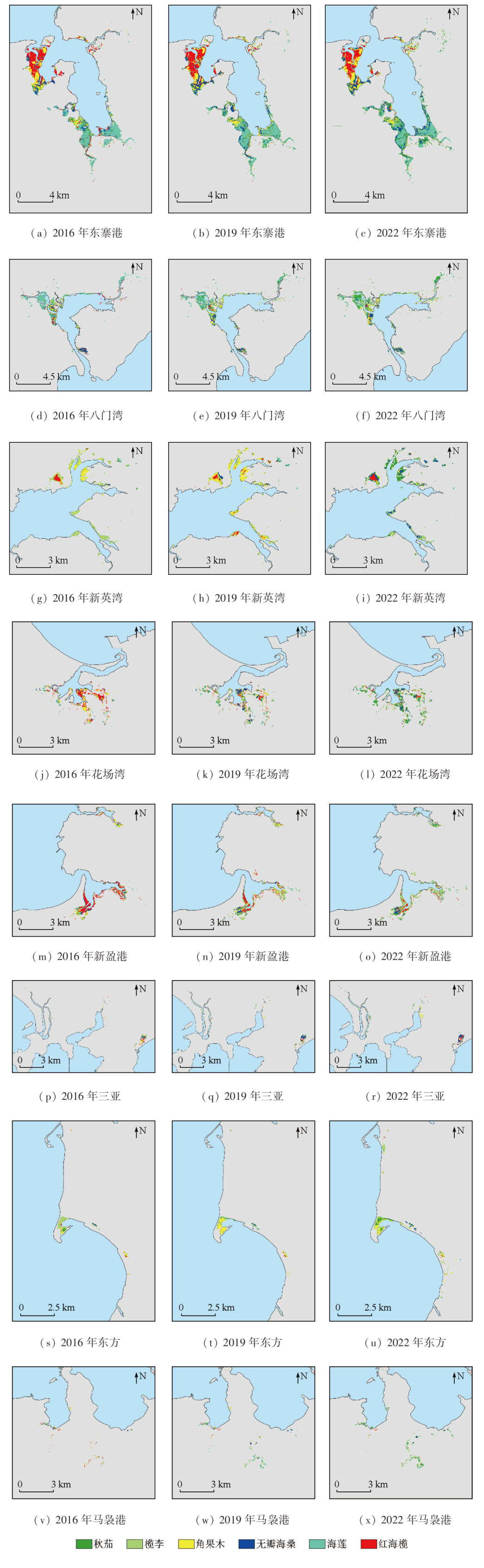
Abstract Based on multitemporal remote sensing (Sentinel-1/2) image data, the digital elevation model (DEM), and the Google Earth Engine (GEE) platform, this study achieved the large-scale dynamic monitoring of the ranges and interspecific distributions of mangrove forests in Hainan Island in 2016, 2019, and 2022. The effects of Sentinel-1 polarization and DEM-derived topographic features were considered in distinguishing mangrove species. Compared to the species identification using only Sentinel-2 image data, the identification method incorporating polarization or topographic features improved the classification accuracy by 3.34 and 3.35 percentage points, respectively. Moreover, incorporating both polarization and topographic features into the identification process was more effective for the interspecific classification of mangrove forests, raising the classification accuracy by 4.07 percentage points and enabling more accurate extraction of different species information. The monitoring results indicate that the areas of mangrove forests in Hainan Island in 2016, 2019, and 2022 were 3628.738 hm2, 3634.129 hm2, and 3881.212 hm2, respectively, showing an overall increase at an average annual rate of 1.127% over six years. Regarding population dynamics, the dominant species included Ceriops tagal and Rhizophora stylosa in the northern mangrove forest in Dongzhai port, and Bruguiera sexangula in the southern portion. The northern estuary of Bamen Bay was dominated by Bruguiera sexangula, while the Wenjiao River mouth exhibited richer species. In the Xinying, and Huachang bays, and Maniao Port, the dominant mangrove species shifted from Ceriops tagal and Rhizophora stylosa to Kandelia obovata and Lumnitzera racemosa over six years, with Sonneratia apetala spreading at the bay mouths. In Xinying Port, the dominant mangrove species shifted from Rhizophora stylosa and Rhizophora stylosa to Lumnitzera racemose. The distribution of Kandelia obovata in Dongfang City expanded gradually, while the species composition in Sanya City remained almost stable, with the growth area occupied primarily by Ceriops tagal. Overall, the method used in this study enhances the identification accuracy of mangrove species, allowing a fine-scale analysis of the evolutionary process of mangrove species, thereby supporting the formulation of the mangrove forest protection policy.
|
| Keywords
mangrove forest
Google Earth Engine
mangrove species
Hainan Island
|
|
|
|
Issue Date: 09 May 2025
|
|
|
| [1] |
自然资源部海洋预警监测司. 红树林生态系统碳储量调查与评估技术规程[S]. 北京: 自然资源部, 2023:3.
|
| [1] |
Marine Early Warning Monitoring Division of Ministry of Natural Resources. Technical regulations for carbon storage investigation and assessment in mangrove ecosystems[S]. Beijing: Ministry of Natural Resources of the People’s Republic of China, 2023:3.
|
| [2] |
陈光程, 陈顺洋, 陈彬, 等. 红树林生态修复手册[R]. 厦门: 自然资源部第三海洋研究所, 2021.
|
| [2] |
Chen G C, Chen S Y, Chen B, et al. Manual of mangrove ecological restoration[R]. Xiamen: Third Institute of Oceanography,Ministry of Natural Resources, 2021.
|
| [3] |
Krauss K W, Friess D A. World atlas of mangroves[J]. Wetlands:The Journal of the Society of Wetland Scientists, 2011(5):1003-1005.
|
| [4] |
莫燕妮, 庚志忠, 王春晓. 海南岛红树林资源现状及保护对策[J]. 热带林业, 2002, 30(1):46-50.
|
| [4] |
Mo Y N, Geng Z Z, Wang C X. Status of mangrove resources in Hainan Island and its conservation measures[J]. Tropical Forestry, 2002, 30(1):46-50.
|
| [5] |
黄小兰, 张婷, 谭人纲. 海南红树林资源现状与预警研究[J]. 江西师范大学学报(自然科学版), 2018, 42(3):236-241.
|
| [5] |
Huang X L, Zhang T, Tan R G. The studies on current status and pre-warning mechanism of mangroves in Hainan[J]. Journal of Jiangxi Normal University(Natural Science Edition), 2018, 42(3):236-241.
|
| [6] |
Moore R T, Hansen M C. Google Earth Engine:A new cloud-computing platform for global-scale earth observation data and analysis[J]. AGU Fall Meeting Abstracts, 2011.
|
| [7] |
Singha C, Swain K C. Quantifying changes in Sundarbans mangrove forest through GEE cloud computing approach[C]// Proceedings of International Joint Conference on Advances in Computational Intelligence. Singapore:Springer, 2022:113-129.
|
| [8] |
贾凯, 陈水森, 蒋卫国. 粤港澳大湾区红树林长时间序列遥感监测[J]. 遥感学报, 2022, 26(6):1096-1111.
|
| [8] |
Jia K, Chen S S, Jiang W G. Long time-series remote sensing monitoring of mangrove forests in the Guangdong-Hong Kong-Macao Greater Bay Area[J]. National Remote Sensing Bulletin, 2022, 26(6):1096-1111.
|
| [9] |
石敏, 李慧颖, 贾明明. 基于GEE云平台与Landsat数据的山口自然保护区红树林时空变化分析[J]. 自然资源遥感, 2023, 35(2):61-69.doi:10.6046/zrzyyg.2022209.
|
| [9] |
Shi M, Li H Y, Jia M M. Spatio-temporal variations in mangrove forests in the Shankou Mangrove Nature Reserve based on the GEE cloud platform and Landsat data[J]. Remote Sensing for Natural Resources, 2023, 35(2):61-69.doi:10.6046/zrzyyg.2022209.
|
| [10] |
Cao J J, Leng W C, Liu K, et al. Object-based mangrove species classification using unmanned aerial vehicle hyperspectral images and digital surface models[J]. Remote Sensing, 2018, 10(1):89.
|
| [11] |
李想, 刘凯, 朱远辉, 等. 基于资源三号影像的红树林物种分类研究[J]. 遥感技术与应用, 2018, 33(2):360-369.
doi: 10.11873/j.issn.1004-0323.2018.2.0360
|
| [11] |
Li X, Liu K, Zhu Y H, et al. Study on mangrove species classification based on ZY-3 image[J]. Remote Sensing Technology and Application, 2018, 33(2):360-369.
|
| [12] |
徐逸, 甄佳宁, 蒋侠朋, 等. 无人机遥感与XGBoost的红树林物种分类[J]. 遥感学报, 2021, 25(3):737-752.
|
| [12] |
Xu Y, Zhen J N, Jiang X P, et al. Mangrove species classification with UAV-based remote sensing data and XGBoost[J]. National Remote Sensing Bulletin, 2021, 25(3):737-752.
|
| [13] |
Meng Y, Gou R, Bai J, et al. Spatial patterns and driving factors of carbon stocks in mangrove forests on Hainan Island,China[J]. Global Ecology and Biogeography, 2022, 31(9):1692-1706.
|
| [14] |
张雪红. 基于决策树方法的Landsat8 OLI影像红树林信息自动提取[J]. 国土资源遥感, 2016, 28(2):182-187.doi: 10.6046/gtzyyg.2016.02.28.
|
| [14] |
Zhang X H. Decision tree algorithm of automatically extracting mangrove forests information from Landsat8 OLI imagery[J]. Remote Sensing for Land and Resources, 2016, 28(2):182-187.doi: 10.6046/gtzyyg.2016.02.28.
|
| [15] |
刘凯, 彭力恒, 李想, 等. 基于Google Earth Engine的红树林年际变化监测研究[J]. 地球信息科学学报, 2019, 21(5):731-739.
doi: 10.12082/dqxxkx.2019.180354
|
| [15] |
Liu K, Peng L H, Li X, et al. Monitoring the inter-annual change of mangrove based on the Google Earth Engine[J]. Journal of Geo-Information Science, 2019, 21(5):731-739.
|
| [16] |
Yang G, Huang K, Sun W, et al. Enhanced mangrove vegetation index based on hyperspectral images for mapping mangrove[J]. ISPRS Journal of Photogrammetry and Remote Sensing, 2022, 189:236-254.
|
| [17] |
赵阳, 田震, 李尉尉, 等. 基于Sentinel-2 MSI影像与面向对象相结合的红树林树种精细化分类方法研究[J]. 海洋通报, 2023, 42(3):352-360.
|
| [17] |
Zhao Y, Tian Z, Li W W, et al. Study on the refined classification method of mangrove tree species based on Sentinel-2 MSI images combined with object-oriented[J]. Marine Science Bulletin, 2023, 42(3):352-360.
|
| [18] |
Belgiu M, Drăguţ L. Random forest in remote sensing:A review of applications and future directions[J]. ISPRS Journal of Photogrammetry and Remote Sensing, 2016, 114:24-31.
|
| [19] |
Shao Z, Fu H, Li D, et al. Remote sensing monitoring of multi-scale watersheds impermeability for urban hydrological evaluation[J]. Remote Sensing of Environment, 2019, 232:111338.
|
| [20] |
Wang D, Wan B, Qiu P, et al. Mapping height and aboveground bio-mass of mangrove forests on Hainan Island using UAV-LiDAR sampling[J]. Remote Sensing, 2019, 11(18):2156.
|
| [21] |
吴瑞, 陈丹丹, 王道儒, 等. 海南省东寨港红树林资源现状调查分析[J]. 热带农业科学, 2016, 36(9):62-65,71.
|
| [21] |
Wu R, Chen D D, Wang D R, et al. Survey of mangrove resources in Dongzhai Harbour,Hainan Province[J]. Chinese Journal of Tropical Agriculture, 2016, 36(9):62-65,71.
|
| [22] |
吴瑞, 陈晓慧, 涂志刚, 等. 海南省三亚河和青梅港红树林群落调查[J]. 热带农业工程, 2018, 42(1):31-33.
|
| [22] |
Wu R, Chen X H, Tu Z G, et al. Current status of mangrove community in Sanya River and Qingmei Bay of Hainan Province[J]. Tropical Agricultural Engineering, 2018, 42(1):31-33.
|
|
Viewed |
|
|
|
Full text
|
|
|
|
|
Abstract
|
|
|
|
|
Cited |
|
|
|
|
| |
Shared |
|
|
|
|
| |
Discussed |
|
|
|
|
 2025,
Vol. 37
2025,
Vol. 37
 ), LI Weiwei, TIAN Zhen, ZHU Mingjie, ZHU Jianhua(