|
|
 |
|

|
|
|
Band selection optimization for constructing water indices based on Sentinel-2A/B data |
XIA Xingsheng1,2,3( ), LEI Boyang1,2,3, DOU Chunjuan1,2,3, CHEN Qiong1,2,3, PAN Yaozhong1,4 ), LEI Boyang1,2,3, DOU Chunjuan1,2,3, CHEN Qiong1,2,3, PAN Yaozhong1,4 |
1. Key Laboratory of Tibetan Plateau Land Surface Processes and Ecological Conservation (Ministry of Education), Qinghai Normal University, Xining 810016, China
2. Qinghai Provincial Key Laboratory of Physical Geography and Environmental Process, School of Geographical Science, Qinghai Normal University, Xining 810016, China
3. Academy of Plateau Science and Sustainability, Qinghai Normal University, Xining 810016, China
4. State Key Laboratory of Remote Sensing Science, Faculty of Geographical Science, Beijing Normal University, Beijing 100875, China |
|
|
|
|
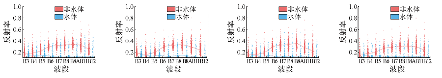
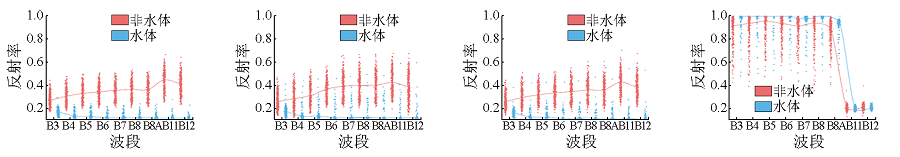
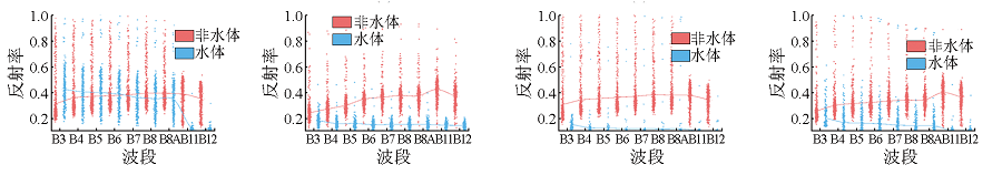
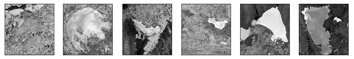
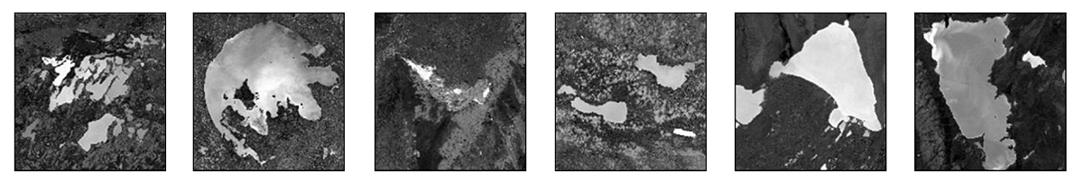
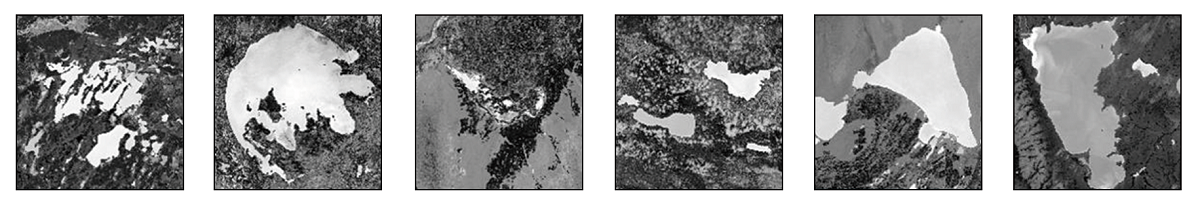
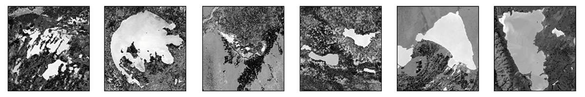
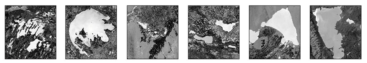
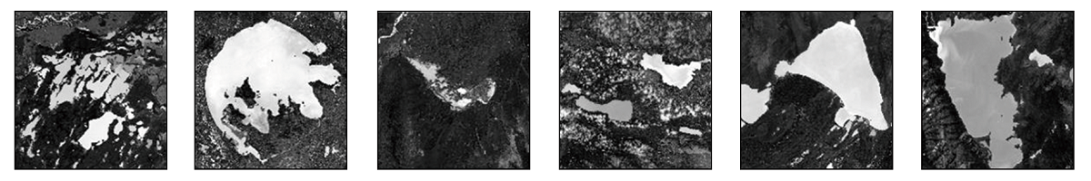
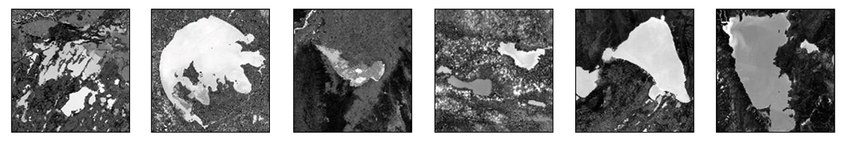
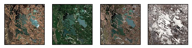
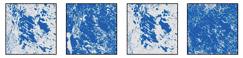
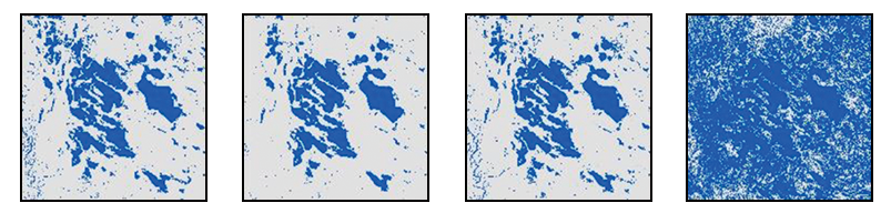
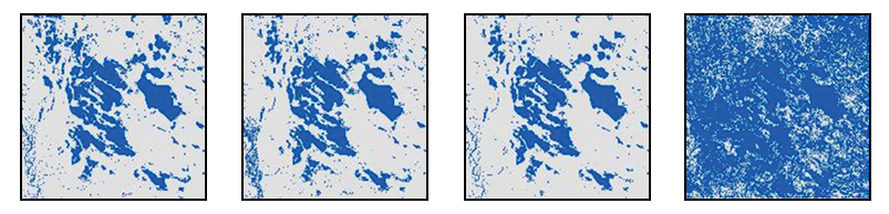
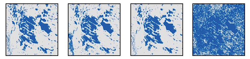
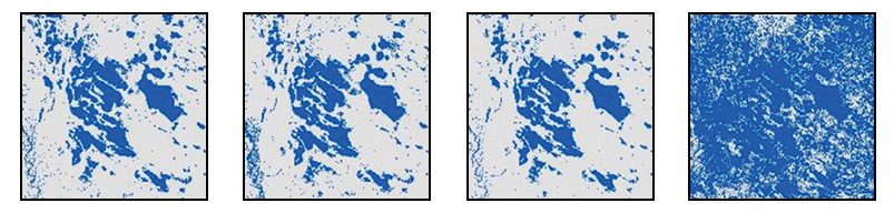
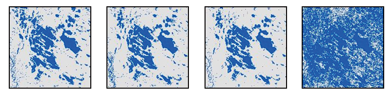
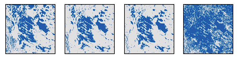
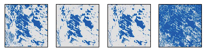
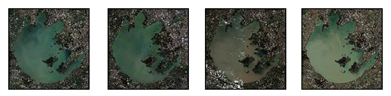
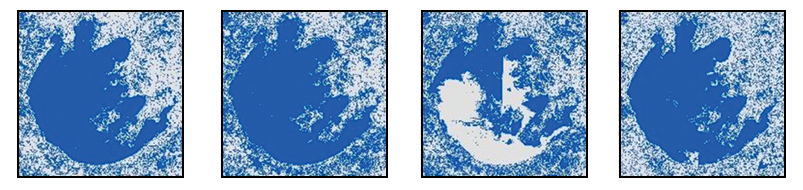
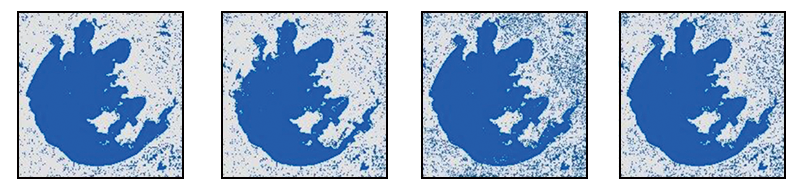
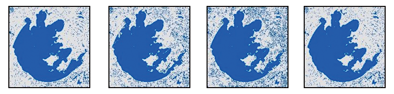
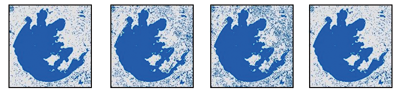
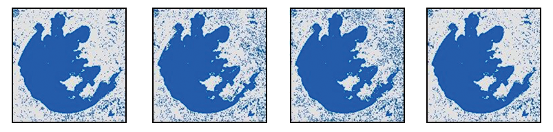
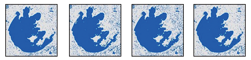
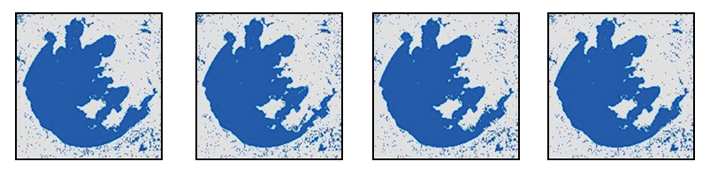
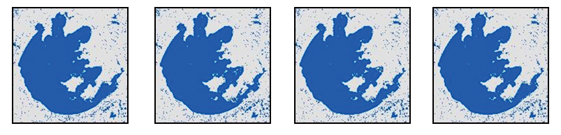
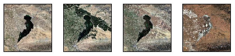
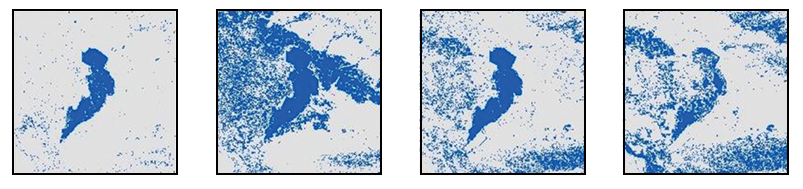
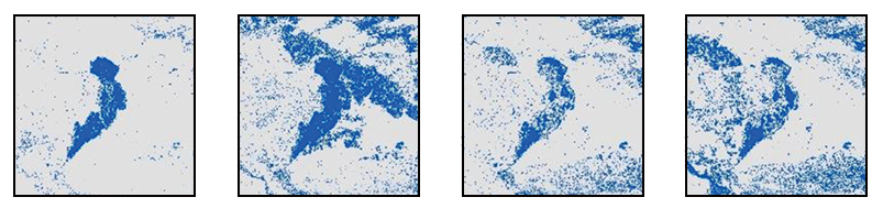
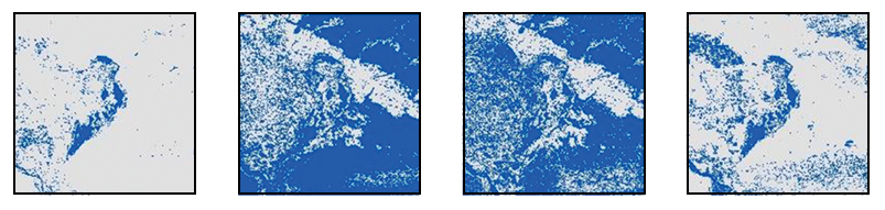
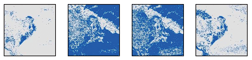
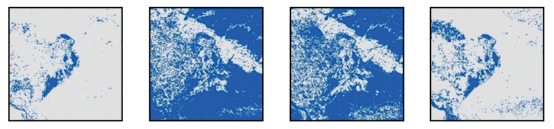
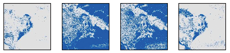
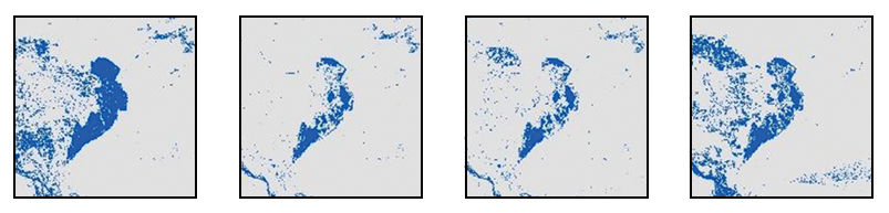
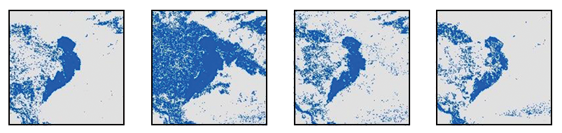
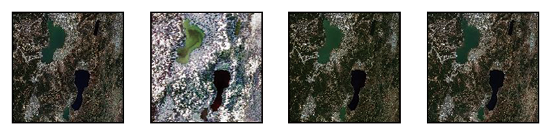
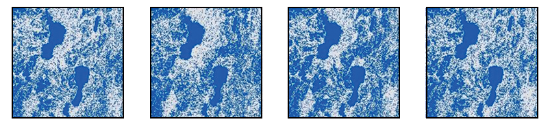
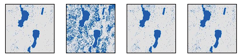
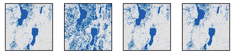
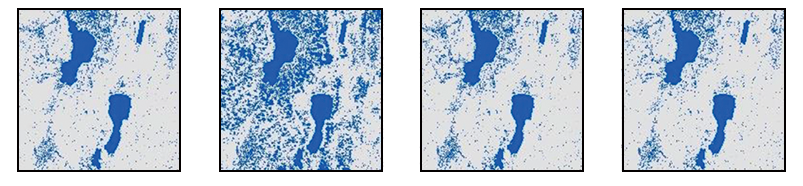
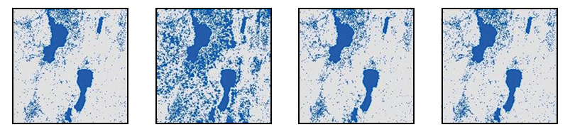
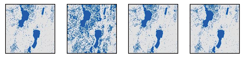
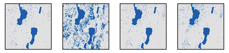
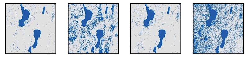
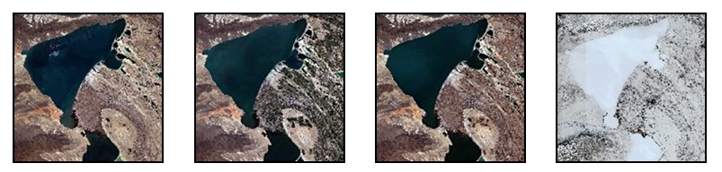
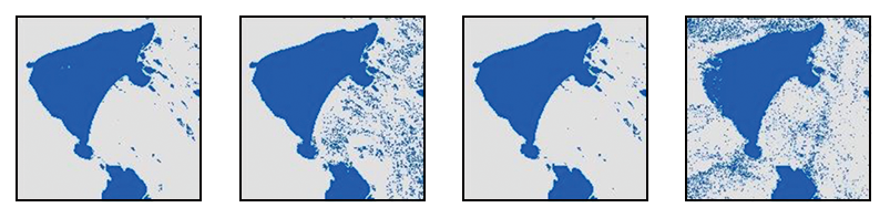
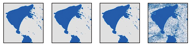
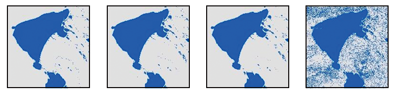
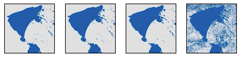
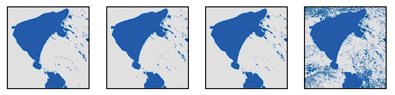
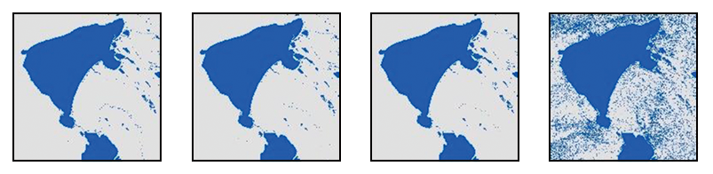
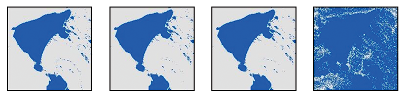
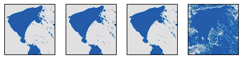
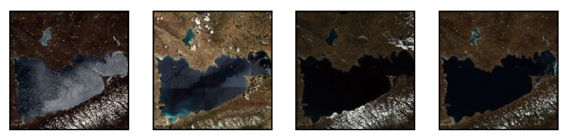
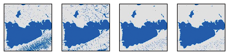
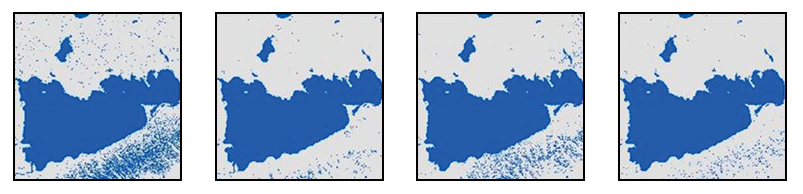
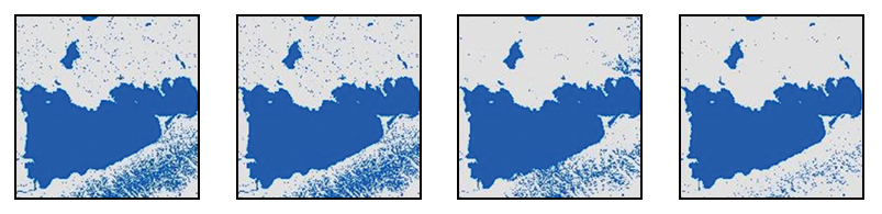
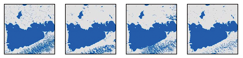
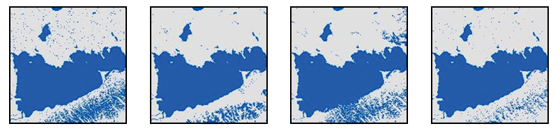
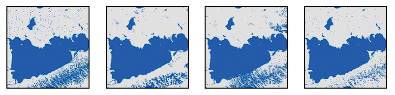
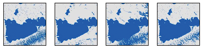
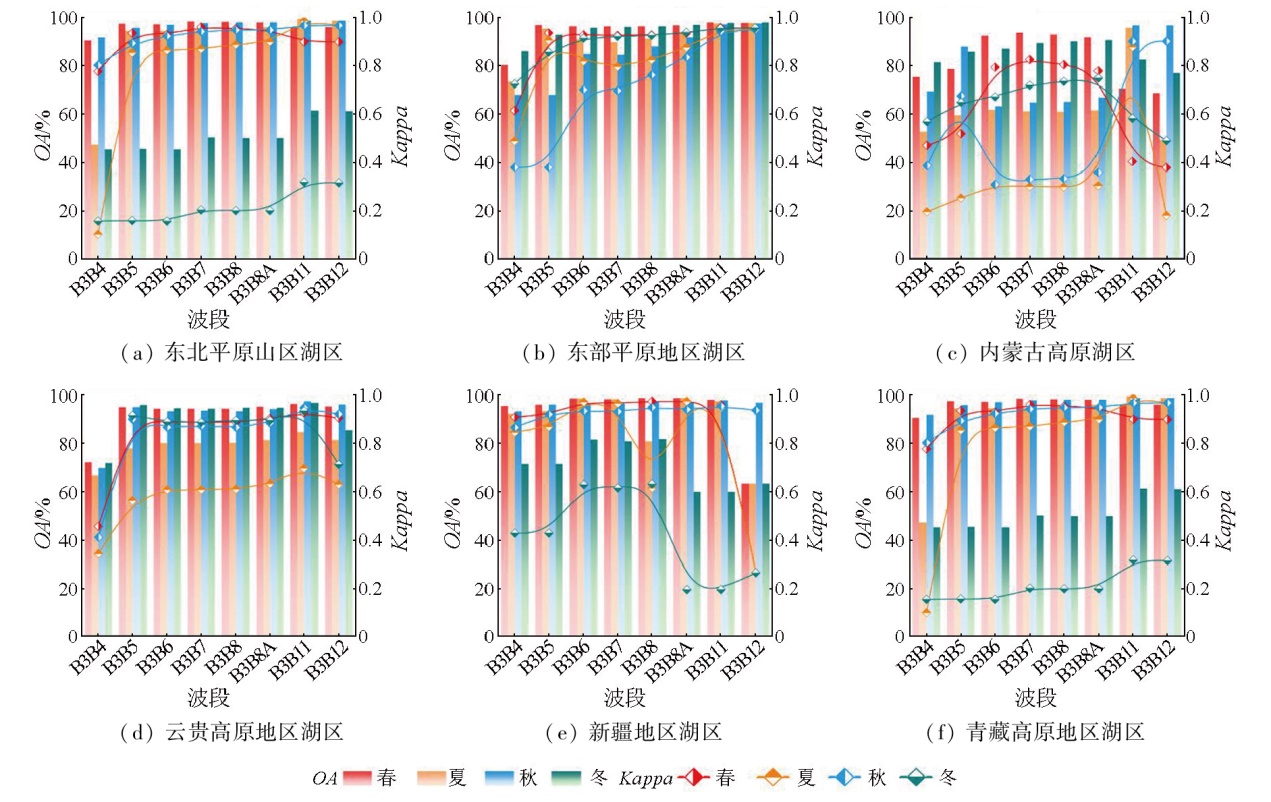
Abstract The simple and efficient water index method has been widely used to monitor and identify surface water along with its spatiotemporal variations. However, with the application of narrow-band multispectral sensors, this method faces a challenge in selecting optimal bands with similar features when the data source changes during large-scale water monitoring. Guided by the normalized difference water index (NDWI) and the modified NDWI (MNDWI), and based on the Google Earth Engine (GEE) platform, this study constructed water indices using the green bands and eight red bands from the Sentienl-2A/B multispectral sensor data. Employing Otsu's method, this study identified and extracted water bodies in six quadrats measuring 90 km × 90 km across different temporal and spatial ranges in China. The results indicate that the optimal band combination for water body extraction varied across different times and locations. Compared to the eight water indices constructed from the Sentienl-2A/B multispectral sensor data, the water index based on the combination of B3 and B11 bands, combined with Otsu's method, achieved optimal water identification and extraction results. These results were observed in summer in the lake regions of the Northeast China Plain and mountains, the eastern plains, the Inner Mongolian Plateau, the Yunnan-Guizhou Plateau, Xinjiang, and the Qinghai-Tibet Plateau. In both spring and summer, the water index based on the combination of B3 and B11 bands exhibited an overall accuracy (OA) exceeding 90% and a Kappa coefficient above 0.9, indicating its applicability across different time periods. Overall, the results of this study provide a reference for the design and development of sensors targeting water extraction and monitoring, and for feature band selection in water monitoring and extraction applications based on narrow-band remote sensing data.
|
| Keywords
Sentinel-2A/B
water index
water body extraction
band selection optimization
Google Earth Engine (GEE)
|
|
|
|
Issue Date: 31 December 2025
|
|
|
| [1] |
Seelen L M S, Flaim G, Jennings E, et al. Saving water for the future:Public awareness of water usage and water quality[J]. Journal of Environmental Management, 2019,242:246-257.
|
| [2] |
李龙杰, 杨永辉. 基于Landsat8 OLI影像的常用水体指数法分类精度对比[J]. 中国科学院大学学报(中英文), 2024, 41(6):755-765.
|
| [2] |
Li L J, Yang Y H. Comparison study on classification accuracy of 11 common water indices based on Landsat8 OLI images[J]. Journal of University of Chinese Academy of Sciences, 2024, 41(6):755-765.
|
| [3] |
Abdelmalik K W. Role of statistical remote sensing for inland water quality parameters prediction[J]. The Egyptian Journal of Remote Sensing and Space Science, 2018, 21(2):193-200.
doi: 10.1016/j.ejrs.2016.12.002
url: https://linkinghub.elsevier.com/retrieve/pii/S1110982316300576
|
| [4] |
Kasvi E, Salmela J, Lotsari E, et al. Comparison of remote sensing based approaches for mapping bathymetry of shallow,clear water rivers[J]. Geomorphology, 2019,333:180-197.
|
| [5] |
Ma S F, Zhou Y T, Gowda P H, et al. Application of the water-related spectral reflectance indices:A review[J]. Ecological Indicators, 2019,98:68-79.
|
| [6] |
McFeeters S K. The use of the normalized difference water index (NDWI) in the delineation of open water features[J]. Internatio-nal Journal of Remote Sensing, 1996, 17(7):1425-1432.
|
| [7] |
Xu H Q. Modification of normalised difference water index (NDWI) to enhance open water features in remotely sensed imagery[J]. International Journal of Remote Sensing, 2006, 27(14):3025-3033.
doi: 10.1080/01431160600589179
url: https://www.tandfonline.com/doi/full/10.1080/01431160600589179
|
| [8] |
闫霈, 张友静, 张元. 利用增强型水体指数(EWI)和GIS去噪音技术提取半干旱地区水系信息的研究[J]. 遥感信息, 2007, 22(6):62-67.
|
| [8] |
Yan P, Zhang Y J, Zhang Y. A study on information extraction of water system in semi-arid regions with the enhanced water index(EWI) and GIS based noise remove techniques[J]. Remote Sen-sing Information, 2007, 22(6):62-67.
|
| [9] |
许佳峰, 李云梅, 徐杰, 等. 黑臭水体水面阴影提取的自适应阈值算法研究[J]. 地球信息科学学报, 2020, 22(10):1959-1970.
doi: 10.12082/dqxxkx.2020.190489
|
| [9] |
Xu J F, Li Y M, Xu J, et al. Adaptive threshold for surface shadow detection of black and odor water[J]. Journal of Geo-Information Science, 2020, 22(10):1959-1970.
|
| [10] |
李艳华, 丁建丽, 闫人华. 基于国产GF-1遥感影像的山区细小水体提取方法研究[J]. 资源科学, 2015, 37(2):408-416.
|
| [10] |
Li Y H, Ding J L, Yan R H. Extraction of small river information based on China-made GF-1 remote sense images[J]. Resources Science, 2015, 37(2):408-416.
|
| [11] |
Naik B C, Anuradha B. Time series analysis of water feature extraction using water index techniques from landsat remote sensing images[C]// 2019 Third International conference on I-SMAC (IoT in Social,Mobile,Analytics and Cloud) (I-SMAC).December 12-14,2019. Palladam,India.IEEE, 2019:478-482.
|
| [12] |
张磊, 宫兆宁, 王启为, 等. Sentinel-2影像多特征优选的黄河三角洲湿地信息提取[J]. 遥感学报, 2019, 23(2):313-326.
|
| [12] |
Zhang L, Gong Z N, Wang Q W, et al. Wetland mapping of Yellow River Delta wetlands based on multi-feature optimization of Sentinel-2 images[J]. Journal of Remote Sensing, 2019, 23(2):313-326.
|
| [13] |
王大钊, 王思梦, 黄昌. Sentinel-2和Landsat8影像的四种常用水体指数地表水体提取对比[J]. 国土资源遥感, 2019, 31(3):157-165.doi:10.6046/gtzyyg.2019.03.20.
|
| [13] |
Wang D Z, Wang S M, Huang C. Comparison of Sentinel-2 imagery with Landsat8 imagery for surface water extraction using four common water indexes[J]. Remote Sensing for Land and Resources, 2019, 31(3):157-165.doi:10.6046/gtzyyg.2019.03.20.
|
| [14] |
张磊, 韩秀珍, 翁富忠, 等. 基于Sentinel-2A MSI数据的水体信息提取算法对比研究[J]. 激光与光电子学进展, 2022, 59(12):505-515.
|
| [14] |
Zhang L, Han X Z, Weng F Z, et al. Comparison of water information extraction algorithms based on Sentinel-2A MSI data[J]. Laser and Optoelectronics Progress, 2022, 59(12):505-515.
|
| [15] |
Lacaux J P, Tourre Y M, Vignolles C, et al. Classification of ponds from high-spatial resolution remote sensing:Application to Rift Valley Fever epidemics in Senegal[J]. Remote Sensing of Environment, 2007, 106(1):66-74.
doi: 10.1016/j.rse.2006.07.012
url: https://linkinghub.elsevier.com/retrieve/pii/S0034425706002811
|
| [16] |
Feyisa G L, Meilby H, Fensholt R, et al. Automated water extraction index:A new technique for surface water mapping using Landsat imagery[J]. Remote Sensing of Environment, 2014,140:23-35.
|
| [17] |
Work E A, Gilmer D S. Utilization of satellite data for inventorying prairie ponds and lakes[J]. Photogrammetric Engineering and Remote Sensing, 1976, 42(5):685-694.
|
| [18] |
Rundquist D C, Lawson M P, Queen L P, et al. The relationship between summer-season rainfall events and lake-surface area[J]. JAWRA Journal of the American Water Resources Association, 1987, 23(3):493-508.
doi: 10.1111/jawr.1987.23.issue-3
url: https://onlinelibrary.wiley.com/toc/17521688/23/3
|
| [19] |
冯思维, 杨清华, 贾伟洁, 等. 基于光学遥感的内陆地表水体提取综述[J]. 自然资源遥感, 2024, 36(3):41-56.doi:10.6046/zrzyyg.2023123.
|
| [19] |
Feng S W, Yang Q H, Jia W J, et al. Information extraction of inland surface water bodies based on optical remote sensing:A review[J]. Remote Sensing for Natural Resources, 2024, 36(3):41-56.doi:10.6046/zrzyyg.2023123.
|
| [20] |
张闻松, 宋春桥. 中国湖泊分布与变化:全国尺度遥感监测研究进展与新编目[J]. 遥感学报, 2022, 26(1):92-103.
|
| [20] |
Zhang W S, Song C Q. Spatial distribution and dynamics of lakes in China:Progress in remote sensing monitoring at national scale and new inventory of the maximum lake extent and change trajectory[J]. National Remote Sensing Bulletin, 2022, 26(1):92-103.
doi: 10.11834/jrs.20221290
url: http://www.ygxb.ac.cn/zh/article/doi/10.11834/jrs.20221290/
|
| [21] |
王帆, 李崇贵, 马婷, 等. 一种改进的遥感影像水体信息快速提取方法[J]. 人民长江, 2021, 52(6):223-228.
|
| [21] |
Wang F, Li C G, Ma T, et al. A modified method for water body information rapid extracting from remote sensing image[J]. Yangtze River, 2021, 52(6):223-228.
|
| [22] |
白元明, 孔令成, 张志华, 等. 基于改进OTSU算法的快速作物图像分割[J]. 江苏农业科学, 2019, 47(24):231-236.
|
| [22] |
Bai Y M, Kong L C, Zhang Z H, et al. Segmentation of fast crop ima-ge based on improved OTSU algorithm[J]. Jiangsu Agricultural Sciences, 2019, 47(24):231-236.
|
| [23] |
汪恩良, 徐雷, 韩红卫, 等. 基于OTSU算法提取寒区河流流冰密度研究[J]. 应用基础与工程科学学报, 2021, 29(6):1429-1439.
|
| [23] |
Wang E L, Xu L, Han H W, et al. Extracting river ice concentration in cold regions based on the OTSU algorithm[J]. Journal of Basic Science and Engineering, 2021, 29(6):1429-1439.
|
| [24] |
刘东, 欧阳安, 陈聪, 等. 基于归一化植被指数的农田边界识别方法[J]. 江苏农业科学, 2022, 50(11):196-201.
|
| [24] |
Liu D, Ouyang A, Chen C, et al. Farmland boundary recognition method based on NDVI[J]. Jiangsu Agricultural Sciences, 2022, 50(11):196-201.
|
| [25] |
刘纪红, 王铖媛. 一种基于自适应阈值的图像二值化算法[C]// 2009中国控制与决策会议论文集·桂林, 2009:498-502.
|
| [25] |
Liu J H, Wang C Y. An image binarization algorithm based on adaptive threshold[C]// 2009 Proceedings of the Chinese Conference on Control and Decision·guilin, 2009:498-502.
|
| [26] |
刘玉梅. 不同水体提取方法的提取效果比较[J]. 陕西水利, 2021(11):104-106.
|
| [26] |
Liu Y M. Comparison of extraction effects of different water extraction methods[J]. Shaanxi Water Resources, 2021(11):104-106.
|
| [27] |
戴芹, 刘士彬, 刘巍. 基于GEE云平台和多源数据的土地覆盖智能分类算法对比研究[J]. 地理与地理信息科学, 2020, 36(6):26-31.
|
| [27] |
Dai Q, Liu S B, Liu W. Comparison of land cover intelligent classification algorithms based on GEE cloud platform and multi-source data[J]. Geography and Geo-Information Science, 2020, 36(6):26-31.
|
| [28] |
Allouche O, Tsoar A, Kadmon R. Assessing the accuracy of species distribution models:Prevalence,Kappa and the true skill statistic (TSS)[J]. Journal of Applied Ecology, 2006, 43(6):1223-1232.
doi: 10.1111/jpe.2006.43.issue-6
url: https://besjournals.onlinelibrary.wiley.com/toc/13652664/43/6
|
| [29] |
Niu Z G, Shan Y X, Gong P. Accuracy evaluation of two global land cover data sets over wetlands of China[J]. The-International Archives of the Photogrammetry,Remote Sensing and Spatial Information Sciences, 2012,39:223-228.
|
| [30] |
吴健平, 杨星卫. 遥感数据分类结果的精度分析[J]. 遥感技术与应用, 1995, 10(1):15-24.
|
| [30] |
Wu J P, Yang X W. Accuracy analysis of classification of remotely sensed data[J]. Remote Sensing Technology and Application, 1995, 10(1):15-24.
|
|
Viewed |
|
|
|
Full text
|
|
|
|
|
Abstract
|
|
|
|
|
Cited |
|
|
|
|
| |
Shared |
|
|
|
|
| |
Discussed |
|
|
|
|
 2025,
Vol. 37
2025,
Vol. 37