|
|
 |
|

|
|
|
A registration algorithm of images with special textures coupling a watershed with mathematical morphology |
ZANG Liri1( ), YANG Shuwen1,2,3(), SHEN Shunfa1, XUE Qing1, QIN Xiaowei1 ), YANG Shuwen1,2,3(), SHEN Shunfa1, XUE Qing1, QIN Xiaowei1 |
1. Faculty of Geomatics, Lanzhou Jiaotong University, Lanzhou 730070, China
2. National-Local Joint Engineering Research Center of Technologies and Applications for National Geographic State Monitoring, Lanzhou 730070, China
3. Gansu Provincial Engineering Laboratory for National Geographic State Monitoring, Lanzhou 730070, China |
|
|
|
|
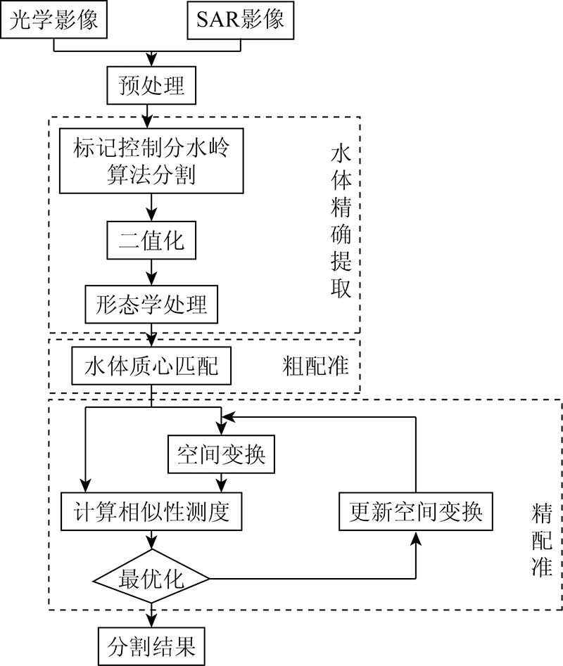
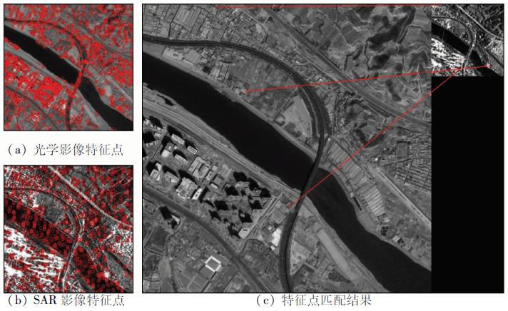
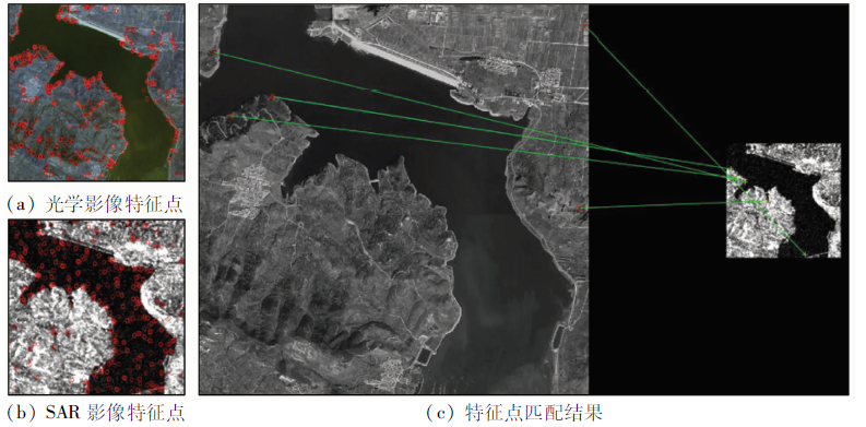
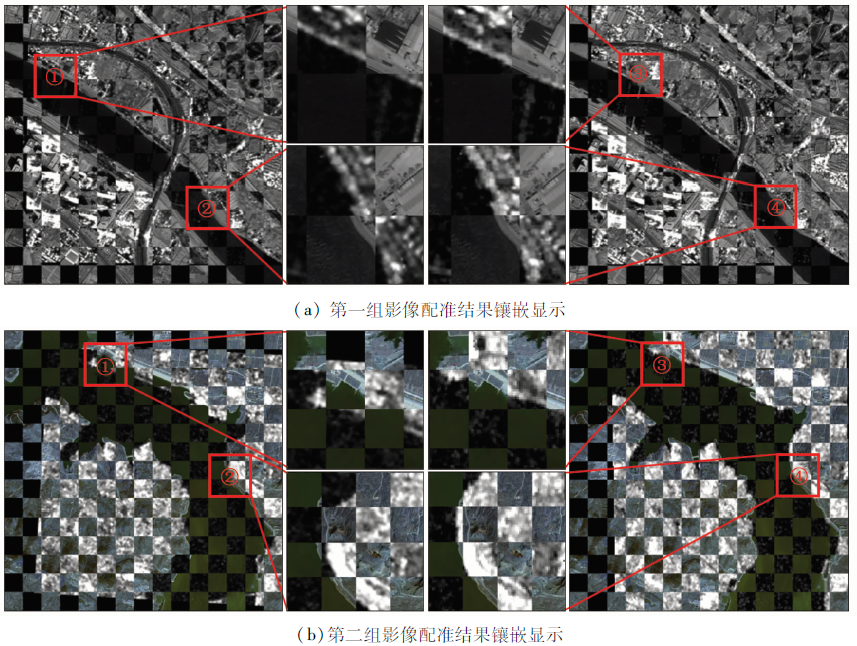
Abstract Existing registration algorithms suffer low efficiency and accuracy in the registration of synthetic aperture Radar (SAR) and optical images. This study proposed a stepwise refinement-based automatic registration algorithm of images with special textures by coupling marker-controlled watershed segmentation and mathematical morphology. Firstly, the improved marker-controlled watershed algorithm was used to extract the features of water bodies from images, and then binarization and mathematical morphology were applied to accurately extract the water regions. Secondly, the centroids of water bodies were extracted for rough registration between images to improve the search efficiency of the subsequent algorithm. Finally, using the optimization algorithm, the optimal transformation parameters when the similarity measure was maximized were obtained and were used to carry out the spatial transformation of SAR images for image registration. In this manner, the precise registration of SAR and optical images was completed. The experimental results show that the algorithm proposed in this study that couples image segmentation with registration reduced calculation amount while ensuring the registration accuracy. Meanwhile, this algorithm effectively solved the difficulty in the automatic registration of SAR and optical high-resolution images that have large differences in gray levels and spatial resolution.
|
| Keywords
SAR
image registration
mark-controled watershed
mathematical morphology
special texture
|
|
|
|
Corresponding Authors:
YANG Shuwen
E-mail: 1525484225@qq.com;ysw040966@163.com
|
|
Issue Date: 14 March 2022
|
|
|
| [1] |
李东宸, 向文豪, 党倩楠, 等. 均匀分布与结构描述ASIFT相结合的SAR与可见光图像配准算法[J]. 测绘学报, 2020, 49(12):1583-1590.
|
| [1] |
Li D C, Xiang W H, Dang Q N, et al. SAR and optical images registration using uniform distribution and structure description-based ASIFT[J]. Acta Geodaetica et Cartographica Sinica, 2020, 49(12):1583-1590.
|
| [2] |
叶沅鑫, 郝思媛, 曹云刚. 基于几何结构属性的光学和SAR影像自动配准[J]. 红外与毫米波学报, 2017, 36(6):720-726.
|
| [2] |
Ye Y X, Hao S Y, Cao Y G. Automatic registration of optical and SAR image using geometric structural properties[J]. Journal of Infrared and Millimeter Waves, 2017, 36(6):720-726.
|
| [3] |
Ye Y X, Bruzzone L, Shan J, et al. Fast and robust matching for multimodal remote sensing image registration[J]. IEEE Transactions on Geoscience and Remote Sensing, 2019, 57(11):9059-9070.
doi: 10.1109/TGRS.36
url: https://ieeexplore.ieee.org/xpl/RecentIssue.jsp?punumber=36
|
| [4] |
张明祥, 王泽根, 白茹月, 等. 一种由粗到精的光学与SAR遥感图像配准算法[J]. 地球信息科学学报, 2020, 22(11):2238-2246.
doi: 10.12082/dqxxkx.2020.190742
|
| [4] |
Zhang M X, Wang Z G, Bai R Y, et al. A coarse-to-fine optical and SAR remote sensing image registration algorithm[J]. Journal of Geo-Information Science, 2020, 22(11):2238-2246.
|
| [5] |
Lowe D G. Distinctive image features from scale-invariant keypoints[J]. International Journal of Computer Vision, 2004, 60(2):91-110.
doi: 10.1023/B:VISI.0000029664.99615.94
url: http://link.springer.com/10.1023/B:VISI.0000029664.99615.94
|
| [6] |
Bay H, Tuytelaars T, Gool L V. SURF:Speeded up robust features[C]// European Conference on Computer Vision.Springer, 2006:404-417.
|
| [7] |
Schwind P, Suri S, Reinartz P, et al. Applicability of the SIFT operator to geometric SAR image registration[J]. International Journal of Remote Sensing, 2010, 31(7-8):1959-1980.
doi: 10.1080/01431160902927622
url: https://www.tandfonline.com/doi/full/10.1080/01431160902927622
|
| [8] |
Xiang Y, Wang F, You H. OS-SIFT:A robust SIFT-like algorithm for high-resolution optical-to-SAR image registration in suburban areas[J]. IEEE Transactions on Geoscience and Remote Sensing, 2018, 56(6):3078.
doi: 10.1109/TGRS.2018.2790483
url: https://ieeexplore.ieee.org/document/8272317/
|
| [9] |
王志社, 杨风暴, 纪利娥, 等. 基于聚类分割和形态学的可见光与SAR图像配准[J]. 光学学报, 2014, 34(2):184-190.
|
| [9] |
Wang Z S, Yang F B, Ji L E, et al. Optical and SAR image registration based on cluster segmentation and mathematical morphology[J]. Acta Optica Sinica, 2014, 34(2):184-190.
|
| [10] |
杨勇, 胡思茹. 基于模板匹配约束下的光学与SAR图像配准[J]. 系统工程与电子技术, 2019, 41(10):2235-2242.
|
| [10] |
Yang Y, Hu S R. Registration of optical and SAR images based on template matching constraints[J]. Systems Engineering and Electronics, 2019, 41(10):2235-2242.
|
| [11] |
Vincent L, Soille P. Watersheds in digital spaces:An efficient algorithm based on immersion simulations[J]. IEEE Transactions on Pattern Analysis and Machine Intelligence, 1991, 13(6):583-598.
doi: 10.1109/34.87344
url: http://ieeexplore.ieee.org/document/87344/
|
| [12] |
韩敬华, 何长涛, 张秋慧, 等. 应用标记控制分水岭分割算法研究激光诱导玻璃体损伤形貌[J]. 光学精密工程, 2010, 18(6):1387-1395.
|
| [12] |
Han J H, He C T, Zhang Q H, et al. Morphological analysis of laser induced glass bulk damage by marker controlling watershed algorithm[J]. Optics and Precision Engineering, 2010, 18(6):1387-1395.
|
| [13] |
Parvati K, Prakasa Rao B S, et al. Image segmentation using gray-scale morphology and marker-controlled watershed transformation[J]. Discrete Dynamics in Nature and Society, 2008:307-318.
|
| [14] |
Genitha C H, Sowmya M, Sri T. Comparative analysis for the detection of marine vessels from satellite images using FCM and marker-controlled watershed segmentation algorithm[J]. Journal of the Indian Society of Remote Sensing, 2020, 48(8):1207-1214.
doi: 10.1007/s12524-020-01148-x
url: https://doi.org/10.1007/s12524-020-01148-x
|
| [15] |
Li P, Xiao X. Multispectral image segmentation by a multichannel watershed-based approach[J]. International Journal of Remote Sensing, 2007, 28(19):4429-4452.
doi: 10.1080/01431160601034910
url: https://www.tandfonline.com/doi/full/10.1080/01431160601034910
|
| [16] |
冈萨雷斯. 数字图像处理(第三版)[M]. 北京: 电子工业出版社, 2017:414-415.
|
| [16] |
Gonzalez. Digital image processing (3rd Edition)[M]. Beijing:Publishing House of Electronics Industry, 2017:414-415.
|
| [17] |
衣文文, 杨彬彬, 胡彦磊, 等. 一种基于外形区域的图像配准方法与实现[J]. 计算机技术与发展, 2008 (4):1-4,8.
|
| [17] |
Yi W W, Yang B B, Hu Y L, et al. Contour-based registration algorithm and its implementation[J]. Computer Technology and Development, 2008(4):1-4,8.
|
| [18] |
Otsu N. Threshold selection method from gray-level histograms[J]. IEEE Transactions on Systems Man and Cybernetics, 1979, 9.
|
| [19] |
Adams R, Bishof L. Seeded region growing[J]. IEEE Transactions on Pattern Analysis and Machine Intelligence, 1994.
|
| [20] |
Dellinger F, Delon J, Gousseau Y, et al. SAR-SIFT:A SIFT-like algorithm for SAR images[J]. IEEE Transactions on Geoscience and Remote Sensing, 2013, 53(1):453-466.
doi: 10.1109/TGRS.2014.2323552
url: http://ieeexplore.ieee.org/document/6824220/
|
| [21] |
Wang X, Duan L, Fan Y, et al. A multi-sensor image matching method based on KAZE-HOG features[C]// 2019 IEEE 4th International Conference on Image,Vision and Computing (ICIVC).IEEE, 2019.
|
| [22] |
孙铭. 基于梯度互信息的SAR与可见光图像配准[D]. 西安:西安电子科技大学, 2015.
|
| [22] |
Sun M. SAR and optical image registration based on gradient mutual information[D]. Xi’an:Xidian University, 2015.
|
| [23] |
叶发茂, 罗威, 苏燕飞, 等. 卷积神经网络特征在遥感图像配准中的应用[J]. 自然资源遥感, 2019, 31(2):32-37.doi: 10.6046/gtzyyg.2019.02.05.
doi: 10.6046/gtzyyg.2019.02.05
|
| [23] |
Ye F M, Luo W, Su Y F, et al. Application of convolutional neural network feature to remote sensing image registration[J]. Remote Sensing for Land and Resources, 2019, 31(2):32-37.doi: 10.6046/gtzyyg.2019.02.05.
doi: 10.6046/gtzyyg.2019.02.05
|
|
Viewed |
|
|
|
Full text
|
|
|
|
|
Abstract
|
|
|
|
|
Cited |
|
|
|
|
| |
Shared |
|
|
|
|
| |
Discussed |
|
|
|
|
 2022,
Vol. 34
2022,
Vol. 34