|
|
 |
|

|
|
|
Paleodrainage network in the Xiong’an New Area: Remote sensing-based reconstruction and relationship with town planning |
SUN Xiyong1,3( ), LI Jingjing2(), ZHANG Ruijiang1, WANG Shaoqiang3,4, JI Xinyang1, LI Guangwei1 ), LI Jingjing2(), ZHANG Ruijiang1, WANG Shaoqiang3,4, JI Xinyang1, LI Guangwei1 |
1. China Aero Geophysical Survey and Remote Sensing Center for Natural Resources, Beijing 100083, China
2. China University of Geosciences(Beijing), Beijing 100083, China
3. China University of Geosciences (Wuhan), Wuhan 430074,China
4. Institute of Geographic Sciences and Natural Resources Research, Beijing 100101, China |
|
|
|
|
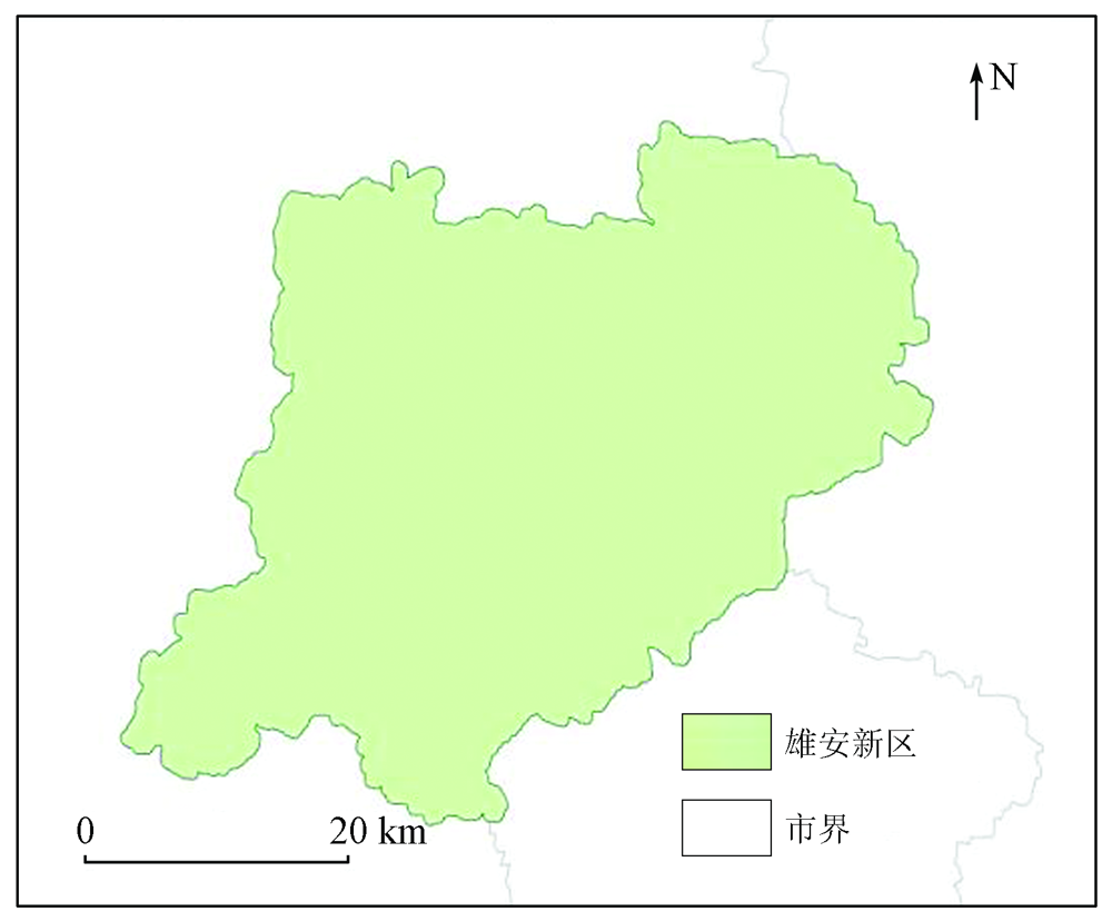
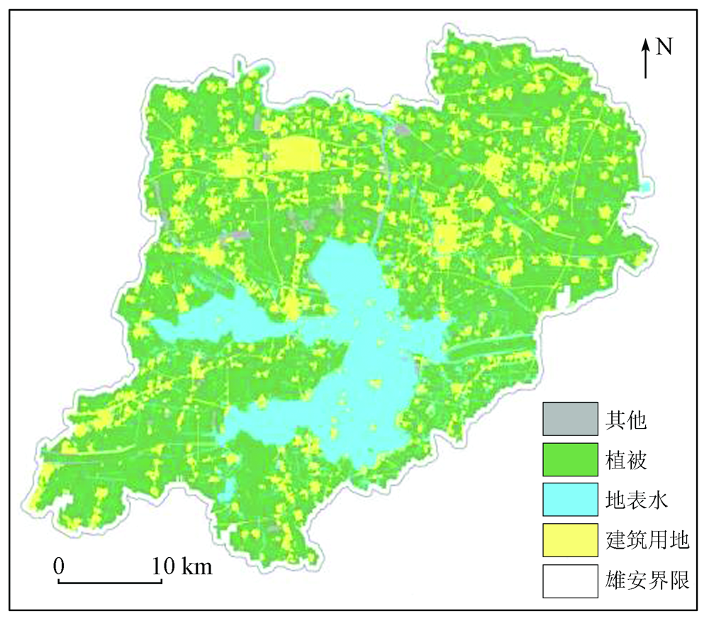
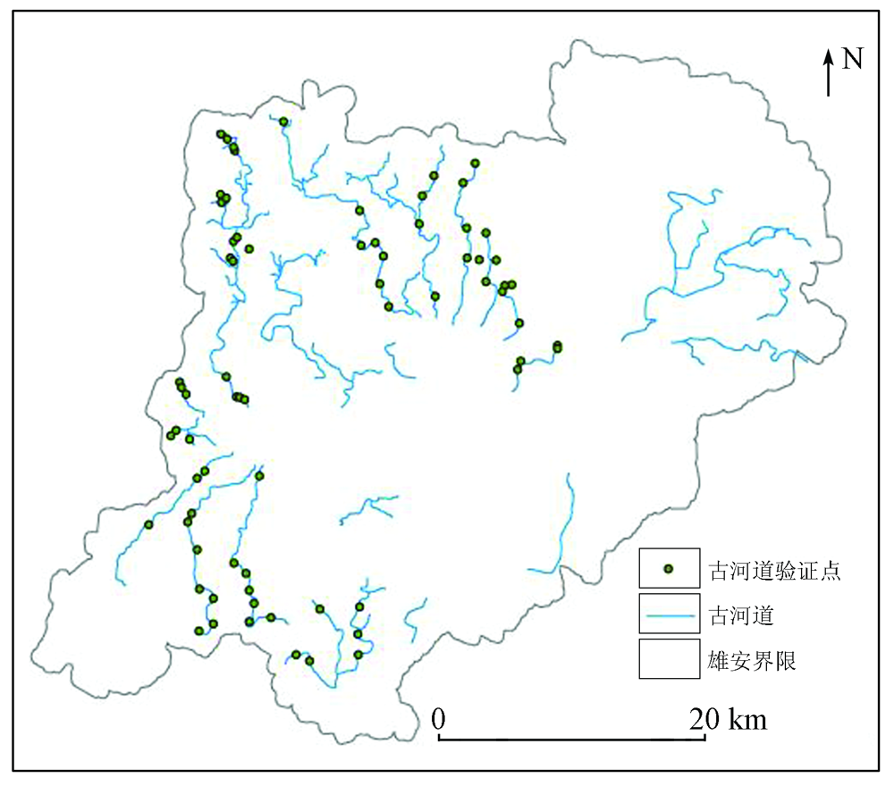
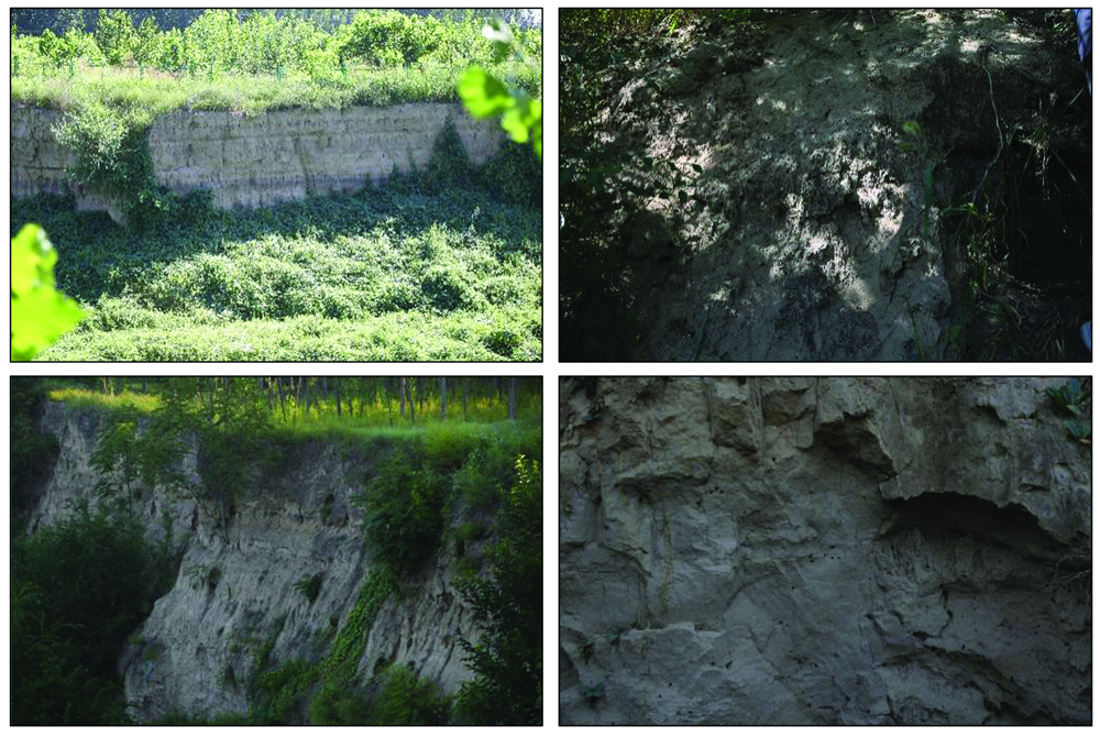
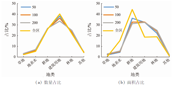
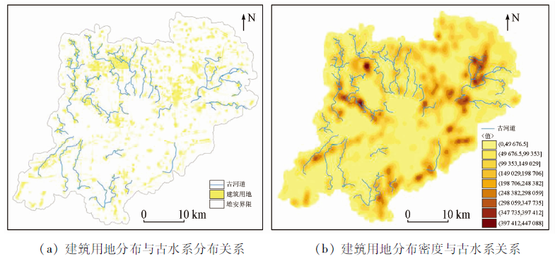
Abstract Xiong’an New Area is a national new area. It has a low groundwater level and close water exchange between the zone of aeration and the saturated zone, with the upward recharge of groundwater increasing the water content in soil. On this basis, with remote sensing images as the data source, this study carried out object-oriented land classification for the study area, extracted the vegetation information by mask, and further extracted the soil moisture information of the vegetation area using the temperature vegetation dryness index (TVDI). Then, by combining the geological and geomorphic characteristics of the palaeochannels in the area, as well as visual interpretation, this study identified the palaeochannels in the study area and verified them in the field. Finally, it reconstructed the paleodrainage system of the study area. The results are as follows: ① The method proposed in this study can effectively extract information on the paleodrainage system in the study area; ② The distribution of the current surface water bodies in the study area is quite different from that of the paleodrainage system; ③ The comparison between the land classification results and the paleodrainage system interpretation results shows that the paleodrainage system was mostly distributed in present construction land, which is present as rural residential areas in remote sensing images. 50 m, 100 m, and 200 m buffer zones were set in the paleodrainage system areas, and then a intersection analysis was made for the buffer zones and the land classification results. The results show that the proportion of construction land in the buffer zones is significantly higher than that of construction land in the whole region. This result indicates that there exists a certain correlation between the distribution of the paleodrainage system and villages.
|
| Keywords
remote sensing
Xiong’an New Area
paleodrainage system
TVDI
|
|
|
|
Issue Date: 20 March 2023
|
|
|
| [1] |
赵艳霞, 徐全洪, 刘芳圆, 等. 近20年来中国古河道研究进展[J]. 地理科学进展, 2013, 32(1):3-19.
|
| [1] |
Zhao Y X, Xu Q H, Liu F Q, et al. Progresses of palaeochannel studies in China in the past 20 years[J]. Progress in geographical science, 2013, 32(1):3-19.
|
| [2] |
王俊, 李家存, 张迪. 基于多源遥感数据的古河道识别方法——以磴口地区古黄河河道为例[J]. 首都师范大学学报(自然科学版), 2019, 40(1):70-77.
|
| [2] |
Wang J, Li J C, Zhang D. Identification of ancient river channels based on multi-source remote sensing data——Take the ancient Yellow River channel in Dengkou Area as an example[J]. Journal of Capital Normal University (Natural Science Edition), 2019, 40(1):70-77.
|
| [3] |
孟广文, 金凤君, 李国平, 等. 雄安新区:地理学面临的机遇与挑战[J]. 地理研究, 2017, 36(6):1003-1013.
doi: 10.11821/dlyj201706001
|
| [3] |
Meng G W, Jin F J, Li G P, et al. Xiong’an New Area:Opportunities and challenges facing geography[J]. Geographical Research, 2017, 36 (6):1003-1013.
|
| [4] |
于长春, 乔日新, 张迪硕. 雄安新区航磁推断的三维基底构造特征[J]. 物探与化探, 2017, 41(3):385-391.
|
| [4] |
Yu C C, Qiao R X, Zhang D S. Three dimensional basement structural characteristics inferred by aeromagnetic in Xiong’an New Area[J]. Geophysical and Geochemical Exploration, 2017, 41(3):385-391.
|
| [5] |
孙禧勇, 苗菁, 于航, 等. 基于多源遥感数据的雄安新区近40年城镇扩展分析[J]. 创新科技, 2018, 18(2):22-26.
|
| [5] |
Sun X Y, Miao J, Yu H, et al. Analysis of urban expansion in Xiong’an New Area in recent 40 years based on multi-source remote sensing data[J]. Innovative Technology, 2018, 18 (2):22-26.
|
| [6] |
吴忱. 河北平原的地面古河道[J]. 地理学报, 1984,(3):268-276.
doi: 10.11821/xb198403017
|
| [6] |
Wu C. Surface paleodrainage in Hebei Plain[J]. Journal of Geography, 1984 (3):268-276.
|
| [7] |
吕霞, 陈蕾, 韩锋, 等. 莱芜市牟汶河利用古水系兴建平原水库工程[J]. 中国水运, 2011, 11(8):188-189.
|
| [7] |
Lv X, Chen L, Han F, et al. Muwen River in Laiwu City uses ancient water system to build plain reservoir project[J]. China Water Transportation, 2011, 11 (8):188-189.
|
| [8] |
Almulla S T, Albadran B N, Al-Ali A. Application of remote sensing techniques to map the paleochannels of Shatt Al-Arab and Khor Al-Zubair,southern Iraq[J]. Marsh Bulletin, 2011, 6(1):23-31.
|
| [9] |
张福堂. 永定河冲积扇及古河道在卫星图象上的显示特征[J]. 水文地质工程地质, 1986(1):54-53.
|
| [9] |
Zhang F T. Display characteristics of Yongding River alluvial fan and ancient channel on satellite image[J]. Hydrogeology and Engineering Geology, 1986(1):54-53.
|
| [10] |
Samadder R K, Kumar S, Gupta R P. Paleochannels and their potential for artificial groundwater recharge in the western Ganga plains[J]. Journal of Hydrology, 2011, 400(1-2):154-164.
doi: 10.1016/j.jhydrol.2011.01.039
url: https://linkinghub.elsevier.com/retrieve/pii/S0022169411000643
|
| [11] |
张竞, 马震, 吴爱民, 等. 基于岩性光谱特征的雄安新区地面古水系识别研究[J]. 地球学报, 2018, 39(5):542-548.
|
| [11] |
Zhang J, Ma Z, Wu A M, et al. Recognition of surface paleodrainage system in Xiong’an New Area based on lithologic spectral characteristics[J]. Acta Geosciences, 2018, 39(5):542-548.
|
| [12] |
秦磊, 詹华明, 宋小军, 等. 基于遥感技术的静海县浅埋古水系分析[J]. 地质调查与研究, 2008, 31(4):321-327.
|
| [12] |
Qin L, Zhan H M, Song X J, et al. Analysis of shallow buried ancient water system in Jinghai County based on remote sensing technology[J]. Geological Survey and Research, 2008, 31(4):321-327.
|
| [13] |
吴爱琴, 刘春迎. 北宋东京城的桥梁建筑特色及影响[J]. 河南大学学报(社会科学版), 2002(3):63-67.
|
| [13] |
Wu A Q, Liu C Y. Bridge architectural characteristics and influence of Tokyo City in the Northern Song Dynasty[J]. Journal of Henan University (Social Science Edition), 2002(3):63-67.
|
| [14] |
高超, 王心源, 金高洁, 等. 巢湖西湖岸新石器—商周遗址空间分布规律及其成因[J]. 地理研究, 2009, 28(4):979-989.
|
| [14] |
Gao C, Wang X Y, Jin G J, et al. Spatial distribution features of archaeological sites (Neolithic Age to Shang & Zhou Dynasties) on the western shore of the Chaohu Lake,China[J]. Geographical Research, 2009, 28(4):979-989.
|
| [15] |
王凯霖, 李海涛, 吴爱民, 等. 人工补水条件下白洋淀湿地演变研究[J]. 地球学报, 2018, 39(5):40-49.
|
| [15] |
Wang K L, Li H T, Wu A M, et al. Study on the evolution of Baiyangdian Wetland under artificial water replenishment[J]. Acta Geosciences, 2018, 39(5):40-49.
|
| [16] |
周莹. 雄安新区4万年以来古环境演化研究[D]. 北京: 中国地质大学(北京), 2020.
|
| [16] |
Zhou Y. Study on the evolution of Paleoenvironment in Xiong’an New Area since 40000 years[D]. Beijing: China University of Geosciences (Beijing), 2020.
|
| [17] |
吴忱, 朱宣清, 何乃华, 等. 华北平原古河道的形成研究[J]. 中国科学(B辑化学生命科学地学), 1991(2):188-197.
|
| [17] |
Wu C, Zhu X Q, He N H, et al. Study on the formation of ancient river channels in North China Plain[J]. Science of China (Part B,Chemistry,Life Sciences and Geosciences), 1991(2):188-197.
|
| [18] |
晏红波, 周国清. 地表土壤湿度光学遥感反演方法研究进展[J]. 亚热带资源与环境学报, 2017, 12(2):82-89,95.
|
| [18] |
Yan H B, Zhou G Q. Research progress of optical remote sensing inversion methods for surface soil moisture[J]. Journal of Subtropical Resources and Environment, 2017, 12(2):82-89,95.
|
| [19] |
谭衢霖, 刘正军, 沈伟. 一种面向对象的遥感影像多尺度分割方法[J]. 北京交通大学学报, 2007(4):111-114,119.
|
| [19] |
Tan Q L, Liu Z J, Shen W. An object-oriented multi-scale segmentation method for remote sensing images[J]. Journal of Beijing Jiaotong University, 2007(4):111-114,119.
|
| [20] |
王杰. 基于面向对象分类和CNN的土地覆盖遥感提取[D]. 合肥: 安徽大学, 2020.
|
| [20] |
Wang J. Remote sensing extraction of land cover based on object-oriented classification and CNN[D]. Hefei: Anhui University, 2020.
|
| [21] |
汤玲英. 基于面向对象方法的Sentinel数据在水体提取中的应用[D]. 长沙: 湖南师范大学, 2018.
|
| [21] |
Tang L Y. Application of sentinel data based on object-oriented method in water extraction[D]. Changsha: Hunan Normal University, 2018.
|
| [22] |
范辽生, 姜纪红, 盛晖, 等. 利用温度植被干旱指数(TVDI)方法反演杭州伏旱期土壤水分[J]. 中国农业气象, 2009, 30(2):230-234.
|
| [22] |
Fan L S, Jiang J H, Sheng H, et al. Inversion of soil moisture during summer drought in Hangzhou by temperature vegetation drought index (TVDI)[J]. China Agrometeorology, 2009, 30(2):230-234.
|
| [23] |
方旭辉. 大清河水系变迁及其对雄安新区建设的影响[D]. 保定: 河北农业大学, 2019.
|
| [23] |
Fang X H. Changes of Daqing River system and its impact on the construction of Xiong’an New Area[D]. Baoding: Hebei Agricultural University, 2019.
|
| [24] |
毛欣, 刘林敬, 宋磊, 等. 白洋淀近70年生态环境演化过程及影响因素[J]. 地球科学, 2021, 46(7):2609-2620.
|
| [24] |
Mao X, Liu L J, Song L, et al. Evolution process and influencing factors of ecological environment in Baiyangdian in recent 70 years[J]. Earth science, 2021, 46(7):2609-2620.
|
| [25] |
孙禧勇, 许玮, 姜德才, 等. 基于遥感的雄安新区地表水时序变化与区域规划研究[J]. 地球物理学进展, 2021, 36(4):1443-1455.
|
| [25] |
Sun X Y, Xu W, Jiang D C, et al. Study on temporal change of surface water and regional planning in Xiong’an New Area based on remote sensing[J]. Advances in geophysics, 2021, 36(4):1443-1455.
|
|
Viewed |
|
|
|
Full text
|
|
|
|
|
Abstract
|
|
|
|
|
Cited |
|
|
|
|
| |
Shared |
|
|
|
|
| |
Discussed |
|
|
|
|
 2023,
Vol. 35
2023,
Vol. 35