|
|
 |
|

|
|
|
Applicability analysis of ground deformation monitoring in mining area by Sentinel - 1A data |
Zechao BAI1, Baocun WANG2( ), Guowang JIN1, Qing XU1, Hongmin ZHANG1, Hui LIU3 ), Guowang JIN1, Qing XU1, Hongmin ZHANG1, Hui LIU3 |
1.Geospatial Information Institute, Information Engineering University, Zhengzhou 450001, China
2.Institute of Surveying, Mapping and Geoinformation, Henan Provincial Bureau of Geo-Exploration and Mineral Development, Zhengzhou 450006, China
3.School of Surverying and Geoinformatics, North China University of Water Resources and Electric Power, Zhengzhou 450046, China |
|
|
|
|
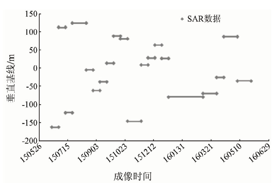
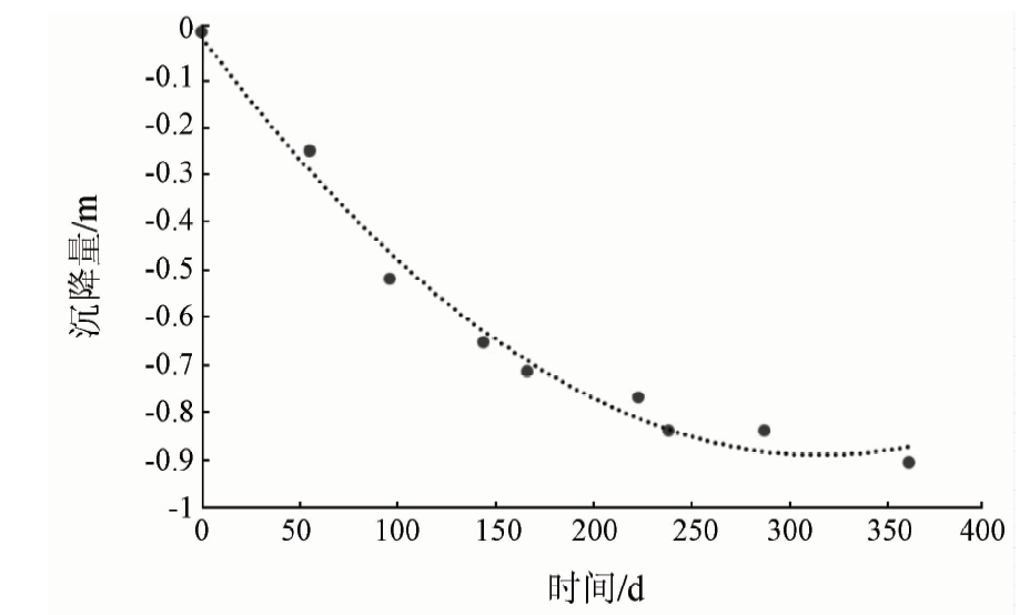
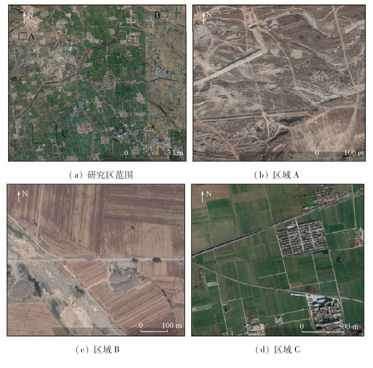
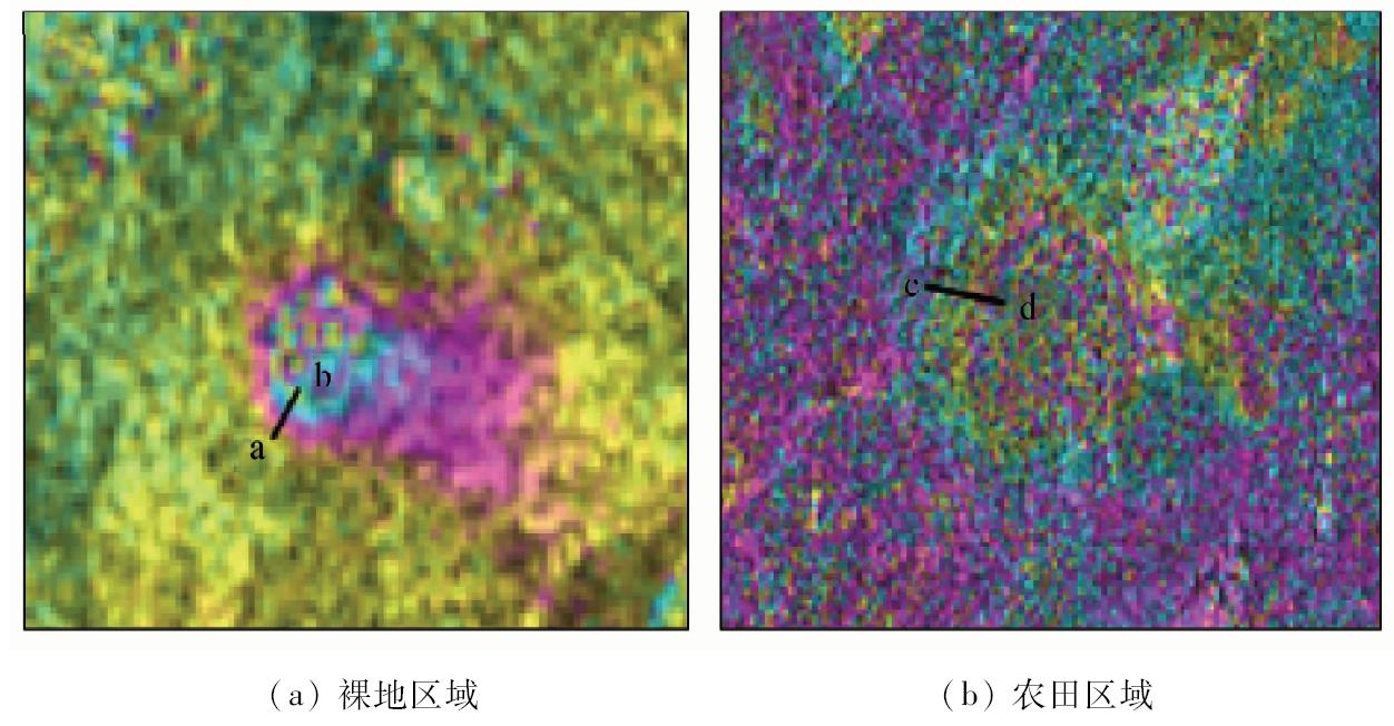
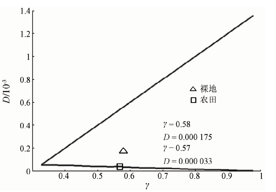
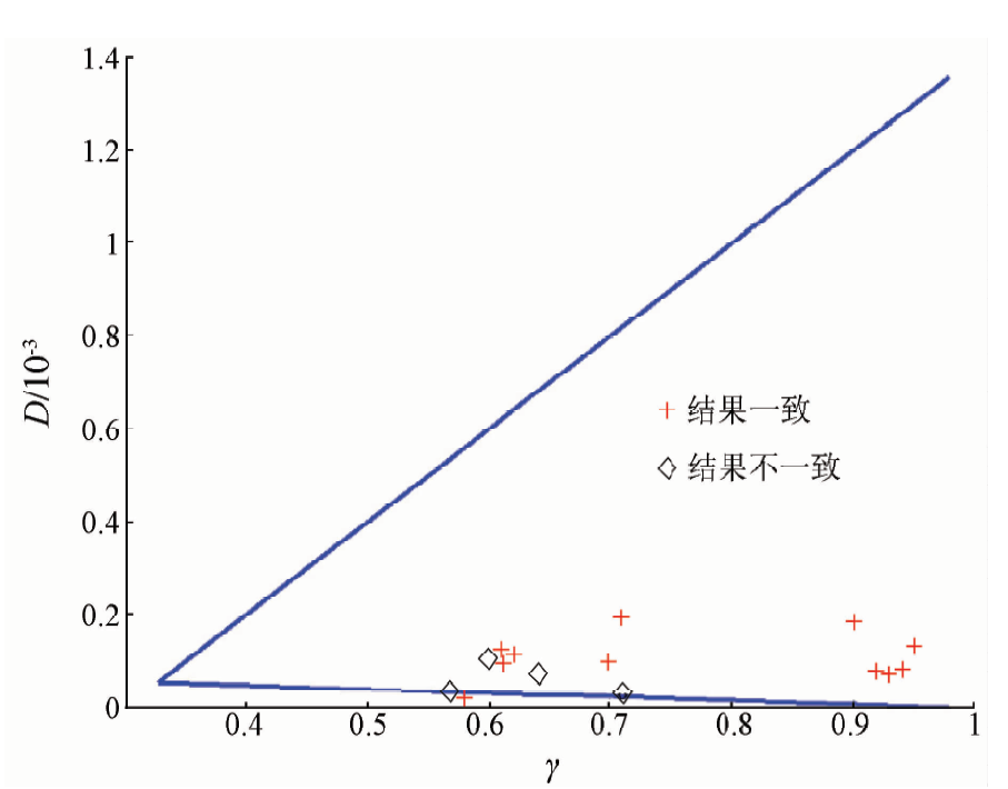
Abstract According to the relationship between the deformation position determination, the deformation gradient estimation and the coherence of the InSAR monitoring surface deformation in the mining area, the Sentinel-1A data were used to study the applicability of the InSAR technique in the monitoring of the mining area. The experimental results show that the surface type of bare land and village is maintained at high coherence throughout the year under the condition of semi - humid monsoon climate in the warm and temperate zone in Henan Province. Visual identification can effectively determine the deformation position of the mining area. The deformation range can not be accurately determined by the deformation gradient function model. The deformation gradient is also within the range of the detectable range. The field coverage type can effectively determine the deformation of the mine in summer. In addition, the deformation gradient is located on the detectable minimum deformation gradient by using the deformation gradient function model. Furthermore, the applicability of the model is proved by the leveling data.
|
| Keywords
InSAR
Sentinel-1A
mine deformation
deformation gradient
coherence
|
|
|
|
Corresponding Authors:
Baocun WANG
E-mail: 309307201@qq.com
|
|
Issue Date: 23 May 2019
|
|
|
| [1] |
靳国旺, 徐青, 张红敏 . 合成孔径雷达干涉测量[M]. 北京: 国防工业出版社, 2014.
|
| [1] |
Jin G W, Xu Q, Zhang H M. Synthetic Aperture Radar Interferometry[M]. Beijing: National Defense Industry Press, 2014.
|
| [2] |
靳国旺, 张红敏, 徐青 . 雷达摄影测量[M]. 北京: 测绘出版社, 2015.
|
| [2] |
Jin G W, Zhang H M, Xu Q. Radargrammetry[M]. Beijing: Surveying and Mapping Press, 2015.
|
| [3] |
吴立新, 高均海, 葛大庆 , 等. 工矿区地表沉陷D-InSAR监测试验研究[J]. 东北大学学报(自然科学版), 2005,26(8):778-782.
|
| [3] |
Wu L X, Gao J H, Ge D Q , et al. Experiental study on surface subsidence monitoring with D-InSAR in mining area[J]. Journal of Northeastern University (Natural Science), 2005,26(8):778-782.
|
| [4] |
董玉森 , Ge L L, Chang H C, 等. 基于差分雷达干涉测量的矿区地面沉降监测研究[J]. 武汉大学学报(信息科学版), 2007,32(10):888-891.
|
| [4] |
Dong Y S, Ge L L, Chang H C , et al. Mine subsidence monitoring by differential InSAR[J]. Geomatics and Information Science of Wuhan University, 2007,32(10):888-891.
|
| [5] |
朱建军, 邢学敏, 胡俊 , 等. 利用InSAR技术监测矿区地表形变[J]. 中国有色金属学报, 2011,21(10):2564-2576.
|
| [5] |
Zhu J J, Xing X M, Hu J , et al. Monitoring of ground surface deformation in mining area with InSAR technique[J]. The Chinese Journal of Nonferrous Metals, 2011,21(10):2564-2576.
|
| [6] |
汪宝存, 郭凌飞, 王军见 , 等. 矿区地表形变InSAR监测——以永城市为例[J]. 测绘与空间地理信息, 2016,39(6):24-27.
|
| [6] |
Wang B C, Guo L F, Wang J J , et al. Mining area surface deformation monitoring by InSAR:Taking Yongcheng City as an example[J]. Geomatics and Spatial Information Technology, 2016,39(6):24-27.
|
| [7] |
刘广, 郭华东 , Ramon H, 等. InSAR技术在矿区沉降监测中的应用研究[J]. 国土资源遥感, 2008,20(2):51-55.doi: 10.6046/gtzyyg.2008.02.13.
doi: 10.6046/gtzyyg.2008.02.13
|
| [7] |
Liu G, Guo H D, Ramon H , et al. The application of InSAR technology to mining area subsidence monitoring[J]. Remote Sensing for Land and Resources, 2008,20(2):51-55.doi: 10.6046/gtzyyg.2008.02.13.
|
| [8] |
廖明生, 王腾 . 时间序列InSAR技术与应用[M]. 北京: 科学出版社, 2014.
|
| [8] |
Liao M S, Wang T. Time Series InSAR Technology and Application[M]. Beijing: Science Press, 2014.
|
| [9] |
田馨 . InSAR技术形变监测中的干涉条件研究[D]. 武汉:武汉大学, 2013.
|
| [9] |
Tian X . The Study on Interference Conditions Analysis for InSAR in Deformation Monitoring[D]. Wuhan:Wuhan University, 2013.
|
| [10] |
葛大庆, 王艳, 范景辉 , 等. 地表形变D-InSAR监测方法及关键问题分析[J]. 国土资源遥感, 2007,19(4):14-22.doi: 10.6046/gtzyyg.2007.04.04.
doi: 10.6046/gtzyyg.2007.04.04
|
| [10] |
Ge D Q, Wang Y, Fan J H , et al. A study of surface deformation monitoring using differential SAR interferometry technique and an analysis of its key problems[J]. Remote Sensing for Land and Resources, 2007,19(4):14-22.doi: 10.6046/gtzyyg.2007.04.04.
|
| [11] |
蒋弥, 李志伟, 丁晓利 , 等. InSAR可检测的最大最小变形梯度的函数模型研究[J]. 地球物理学报, 2009,52(7):1715-1724.
doi: 10.3969/j.issn.0001-5733.2009.07.006
|
| [11] |
Jiang M, Li Z W, Ding X L , et al. A study on the maximum and minimum detectable deformation gradients resolved by InSAR[J]. Chinese Journal of Geophysics, 2009,52(7):1715-1724.
|
| [12] |
Jiang M, Li Z W, Ding X L , et al. Modeling minimum and maximum detectable deformation gradients of interferometric SAR measurements[J]. International Journal of Applied Earth Observation and Geoinformation, 2011,13(5):766-777.
doi: 10.1016/j.jag.2011.05.007
url: https://linkinghub.elsevier.com/retrieve/pii/S030324341100064X
|
| [13] |
Baran I, Stewart M, Claessens S . A new functional model for determining minimum and maximum detectable deformation gradient resolved by satellite Radar interferometry[J]. IEEE Transactions on Geoscience and Remote Sensing, 2005,43(4):675-682.
doi: 10.1109/TGRS.2004.843187
url: http://ieeexplore.ieee.org/document/1411973/
|
|
Viewed |
|
|
|
Full text
|
|
|
|
|
Abstract
|
|
|
|
|
Cited |
|
|
|
|
| |
Shared |
|
|
|
|
| |
Discussed |
|
|
|
|
 2019,
Vol. 31
2019,
Vol. 31