|
|
 |
|

|
|
|
Inversion of tidal flat topography based on unmanned aerial vehicle low-altitude remote sensing and field surveys |
LI Yang1( ), YUAN Lin1,2(), ZHAO Zhiyuan1, ZHANG Jinlei1, WANG Xianye1, ZHANG Liquan1 ), YUAN Lin1,2(), ZHAO Zhiyuan1, ZHANG Jinlei1, WANG Xianye1, ZHANG Liquan1 |
1. State Key Laboratory of Estuarine and Coastal Research, Institute of Eco-Chongming, East China Normal University,Shanghai 200241, China
2. Yangtze Delta Estuarine Wetland Ecosystem Observation and Research Station (Ministry of Education & Shanghai Science and Technology Committee), Shanghai 202162, China |
|
|
|
|
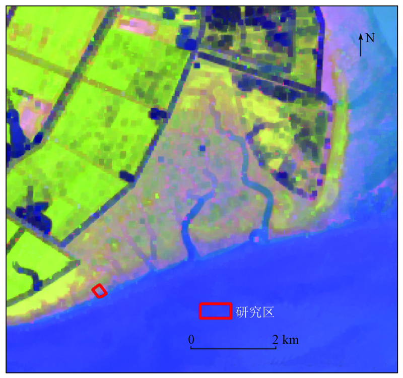
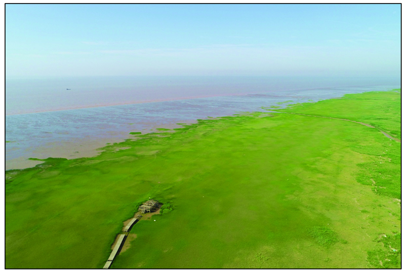
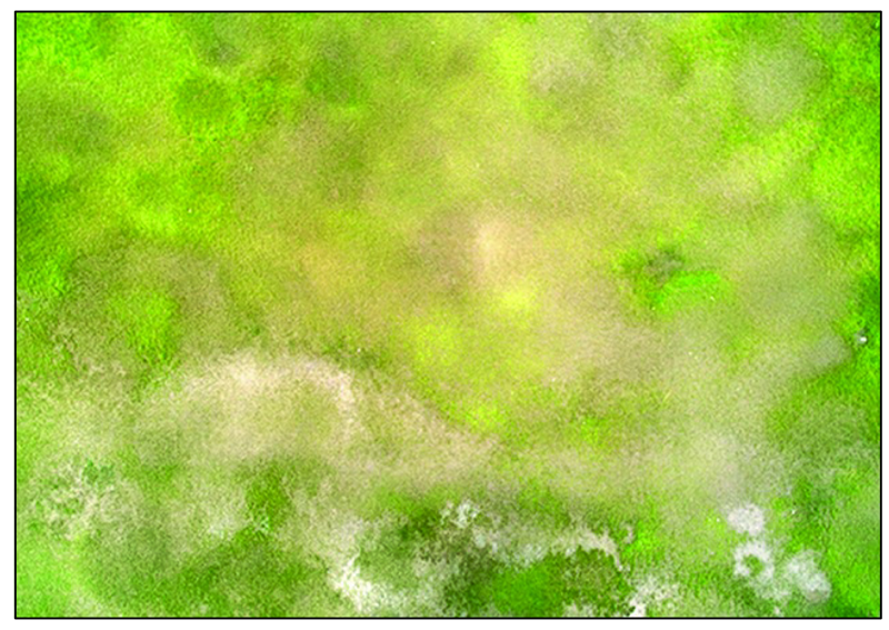
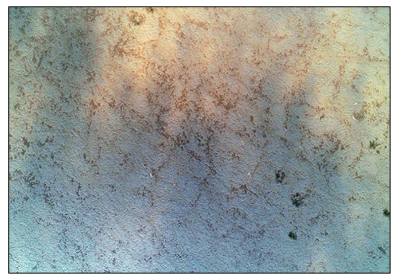
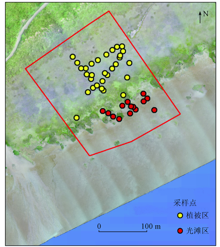
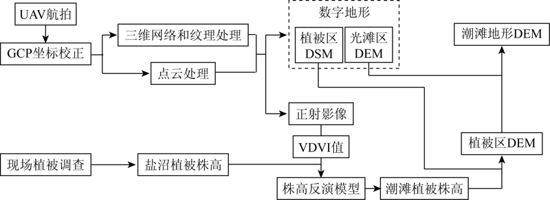
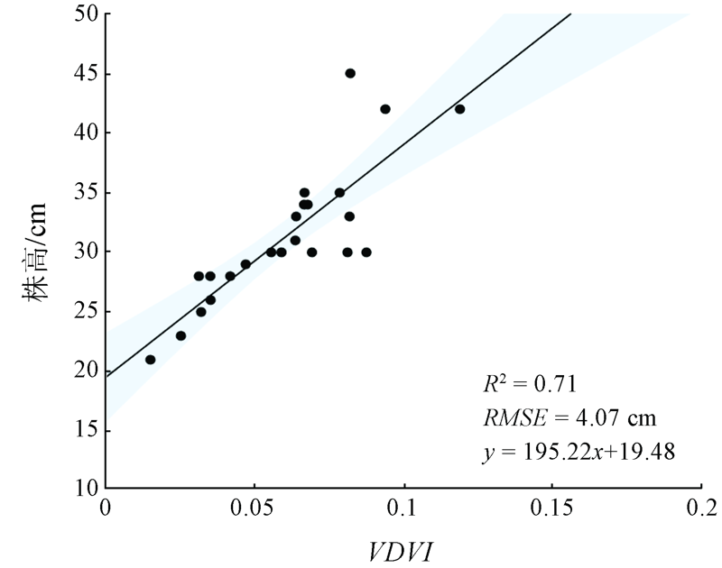
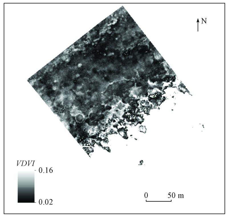
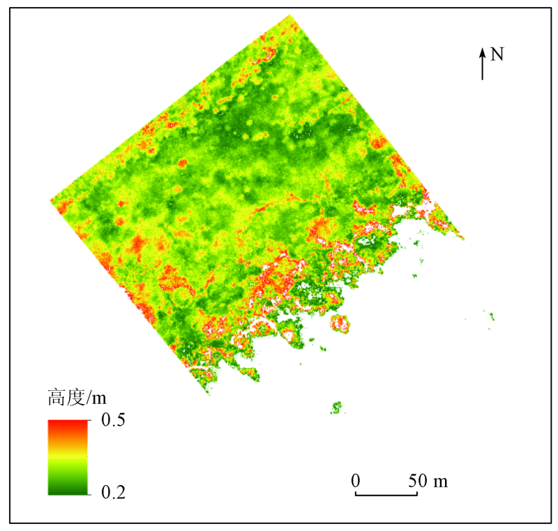
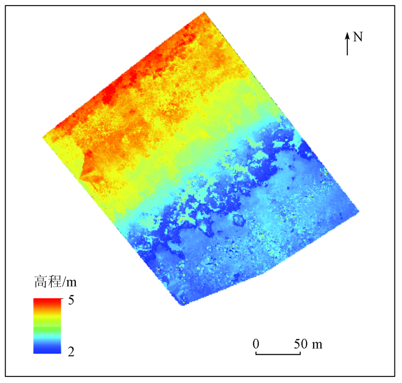
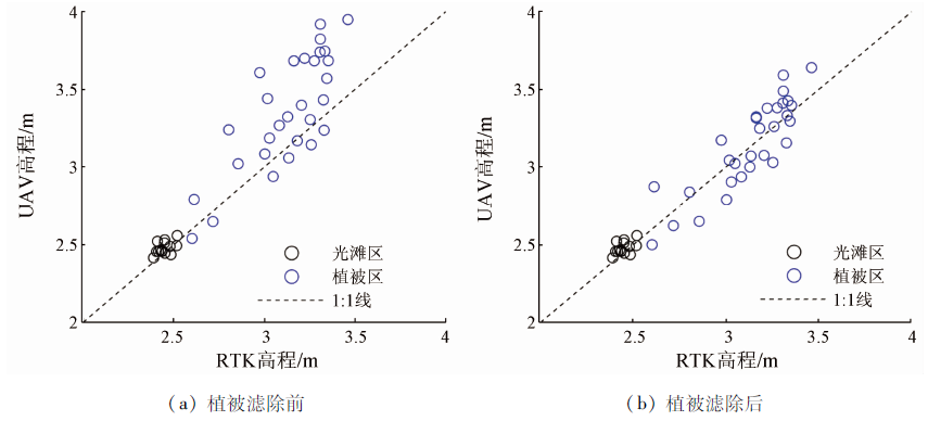
Abstract Tidal flat topography is closely related to the structure and function of the ecosystem in intertidal wetlands. Therefore, it is significant for the analyses of tidal flat dynamics and the monitoring of the diffusion process of saltmarsh vegetation to obtain high-precision topography data. However, owing to limited ebb time, muddy tidal flats, and saltmarsh vegetation, traditional geographic observation techniques suffer the shortcomings such as low accuracy and efficiency, high cost, and limited coverage. In this study, unmanned aerial vehicle (UAV) low-altitude remote sensing was employed to obtain aerial images and their band information. Then the 3D and spectral information with precise coordinates were extracted based on the structure obtained using motion technology. They were used to construct a high-precision digital surface model (DSM) of the study area. The DSM of bare flats can be directly used as the digital elevation model (DEM) of the tidal flat. In the areas with saltmarsh vegetation, the information of red, green, and blue bands was used to calculate the visible-band vegetation index (VDVI), which was combined with field surveys to build an inversion model for vegetation height. Finally, vegetation was filtered out from the DSM using the height inversion model to obtain accurate DEM. In this way, the elevation of the vegetation zone in the tidal flat can be reflected. As indicated by the results of this study, the method that combines UAV low-altitude remote sensing with field surveys can realize precise inversion of tidal flat topography. The root mean square error (RMSE) of the topography in bare flat obtained using the method was 0.07 m and the accuracy was close to the terrestrial laser scanner (TLS). For areas with saltmarsh vegetation, the RMSE was reduced to 0.14 m and the geographical accuracy can be improved by 60% after the vegetation was filtered out. Therefore, the method is superior to traditional point cloud filtering. Overall, this study provided an inversion method of tidal flat topography based on UAV remote sensing and field surveys, which can effectively monitor large-scale natural tidal flat systems. The method can be applied to other similar natural tidal flat systems or coastal areas, providing important technological support for the protection and management of coastal tidal flat wetlands.
|
| Keywords
tidal flat
topography
UAV
vegetation filtering
VDVI
|
|
|
|
Corresponding Authors:
YUAN Lin
E-mail: bigliyang123@126.com;lyuan@sklec.ecnu.edu.cn
|
|
Issue Date: 24 September 2021
|
|
|
| [1] |
Kirwan M L, Megonigal J P. Tidal wetland stability in the face of human impacts and sea-level rise[J]. Nature, 2013, 504(7478):53-60.
doi: 10.1038/nature12856
url: https://doi.org/10.1038/nature12856
|
| [2] |
Duarte C M, Losada I J, Hendriks I E, et al. The role of coastal plant communities for climate change mitigation and adaptation[J]. Nature Climate Change, 2013, 3(11):961-968.
doi: 10.1038/nclimate1970
url: https://doi.org/10.1038/nclimate1970
|
| [3] |
Murray N J, Phinn S R, DeWitt M, et al. The global distribution and trajectory of tidal flats[J]. Nature, 2019, 565(7738):222-225.
doi: 10.1038/s41586-018-0805-8
url: https://doi.org/10.1038/s41586-018-0805-8
|
| [4] |
Kulawardhana R W, Feagin R A, Popescu S C, et al. The role of elevation,relative sea-level history and vegetation transition in determining carbon distribution in Spartina alterniflora dominated salt marshes[J]. Estuarine,Coastal and Shelf Science, 2015, 154:48-57.
doi: 10.1016/j.ecss.2014.12.032
url: https://linkinghub.elsevier.com/retrieve/pii/S0272771414004119
|
| [5] |
Yuan L, Chen Y, Wang H, et al. Windows of opportunity for salt marsh establishment:The importance for salt marsh restoration in the Yangtze Estuary[J]. Ecosphere, 2020, 11(7):e3180.
|
| [6] |
Cui L, Ge Z, Yuan L, et al. Vulnerability assessment of the coastal wetlands in the Yangtze Estuary,China to sea-level rise[J]. Estuarine,Coastal and Shelf Science, 2015, 156:42-51.
doi: 10.1016/j.ecss.2014.06.015
url: https://linkinghub.elsevier.com/retrieve/pii/S0272771414001802
|
| [7] |
Bang J H, Bae M, Lee E J. Plant distribution along an elevational gradient in a macrotidal salt marsh on the west coast of Korea[J]. Aquatic Botany, 2018, 147:52-60.
doi: 10.1016/j.aquabot.2018.03.005
url: https://linkinghub.elsevier.com/retrieve/pii/S0304377017303030
|
| [8] |
陈雅慧, 袁琳, 曹浩冰, 等. 基于胁迫梯度假说和互惠理论的海三棱藨草种群恢复技术[J]. 生态学报, 2019, 39(12):4233-4241.
|
| [8] |
Chen Y H, Yuan L, Cao H B, et al. The stress-gradient hypojournal and facilitation theory-based restoration technique for Scirpus mariqueter population[J]. Acta Ecologica Sinica, 2019, 39(12):4233-4241.
|
| [9] |
Widdows J, Blauw A, Heip C, et al. Role of physical and biological processes in sediment dynamics of a tidal flat in Westerschelde Estuary,SW Netherlands[J]. Marine Ecology Progress Series, 2004, 274:41-56.
doi: 10.3354/meps274041
url: http://www.int-res.com/abstracts/meps/v274/p41-56/
|
| [10] |
De Backer A, Van Colen C, Vincx M, et al. The role of biophysical interactions within the ijzermonding tidal flat sediment dynamics[J]. Continental Shelf Research, 2010, 30(9):1166-1179.
doi: 10.1016/j.csr.2010.03.006
url: https://linkinghub.elsevier.com/retrieve/pii/S0278434310000841
|
| [11] |
Hu S, Niu Z, Chen Y, et al. Global wetlands:Potential distribution,wetland loss,and status[J]. Science of the Total Environment, 2017, 586:319-327.
doi: 10.1016/j.scitotenv.2017.02.001
url: https://linkinghub.elsevier.com/retrieve/pii/S0048969717302425
|
| [12] |
Nelson A, Reuter H, Gessler P. Chapter 3 DEM production methods and sources[J]. Developments in Soil Science, 2009, 33:65-85.
|
| [13] |
魏伟, 周云轩, 田波, 等. 基于地面激光扫描的典型海岸带盐沼潮滩地形反演[J]. 吉林大学学报(地球科学版), 2018, 48(6):1889-1897.
|
| [13] |
Wei W, Zhou Y X, Tian B, et al. Topography retrieval on typical salt marsh of coastal zone based on terrestrial laser scanning[J]. Journal of Jilin University (Earth Science Edition), 2018, 48(6):1889-1897.
|
| [14] |
Telling J, Lyda A, Hartzell P, et al. Review of earth science research using terrestrial laser scanning[J]. Earth-Science Reviews, 2017, 169:35-68.
doi: 10.1016/j.earscirev.2017.04.007
url: https://linkinghub.elsevier.com/retrieve/pii/S0012825216304433
|
| [15] |
Valente D S M, Momin A, Grift T, et al. Accuracy and precision evaluation of two low-cost RTK global navigation satellite systems[J]. Computers and Electronics in Agriculture, 2020, 168:105142.
doi: 10.1016/j.compag.2019.105142
url: https://linkinghub.elsevier.com/retrieve/pii/S0168169918312602
|
| [16] |
Mancini F, Dubbini M, Gattelli M, et al. Using unmanned aerial vehicles (UAV) for high-resolution reconstruction of topography:The structure from motion approach on coastal environments[J]. Remote Sensing, 2013, 5(12):6880-6898.
doi: 10.3390/rs5126880
url: http://www.mdpi.com/2072-4292/5/12/6880
|
| [17] |
Reshetyuk Y, Mårtensson S. Generation of highly accurate digital elevation models with unmanned aerial vehicles[J]. The Photogrammetric Record, 2016, 31(154):143-165.
doi: 10.1111/phor.2016.31.issue-154
url: http://doi.wiley.com/10.1111/phor.2016.31.issue-154
|
| [18] |
Wijesingha J, Moeckel T, Hensgen F, et al. Evaluation of 3D point cloud-based models for the prediction of grassland biomass[J]. International Journal of Applied Earth Observation and Geoinformation, 2019, 78:352-359.
doi: 10.1016/j.jag.2018.10.006
url: https://linkinghub.elsevier.com/retrieve/pii/S0303243418305087
|
| [19] |
Westoby M J, Brasington J, Glasser N F, et al. ‘Structure-from-Motion’ photogrammetry:A low-cost,effective tool for geoscience applications[J]. Geomorphology, 2012, 179:300-314.
doi: 10.1016/j.geomorph.2012.08.021
url: https://linkinghub.elsevier.com/retrieve/pii/S0169555X12004217
|
| [20] |
Han X, Thomasson J A, Bagnall G C, et al. Measurement and calibration of plant-height from fixed-wing UAV images[J]. Sensors, 2018, 18(12):4092.
doi: 10.3390/s18124092
url: http://www.mdpi.com/1424-8220/18/12/4092
|
| [21] |
Kalacska M, Chmura G L, Lucanus O, et al. Structure from motion will revolutionize analyses of tidal wetland landscapes[J]. Remote Sensing of Environment, 2017, 199:14-24.
doi: 10.1016/j.rse.2017.06.023
url: https://linkinghub.elsevier.com/retrieve/pii/S003442571730281X
|
| [22] |
Dai W, Li H, Zhou Z, et al. UAV photogrammetry for elevation monitoring of intertidal mudflats[J]. Journal of Coastal Research, 2018, 85(85):236-240.
doi: 10.2112/SI85-048.1
url: http://www.bioone.org/doi/10.2112/SI85-048.1
|
| [23] |
谢卫明, 何青, 章可奇, 等. 三维激光扫描系统在潮滩地貌研究中的应用[J]. 泥沙研究, 2015, 48(6):1889-1897.
|
| [23] |
Xie W M, He Q, Zhang K Q, et al. Application of the terrestrial laser scanner to measuring geomorphology in tidal flats and salt marshes[J]. Journal of Sediment Research, 2015, 48(6):1889-1897.
|
| [24] |
Zhao Z Y, Yuan L, Li W, et al. Re-invasion of Spartina alterniflora in restored saltmarshes:Seed arrival,retention,germination,and establishment[J]. Journal of Environmental Management, 2020, 266:110631.
doi: 10.1016/j.jenvman.2020.110631
url: https://linkinghub.elsevier.com/retrieve/pii/S0301479720305636
|
| [25] |
汪小钦, 王苗苗, 王绍强, 等. 基于可见光波段无人机遥感的植被信息提取[J]. 农业工程学报, 2015, 31(5):152-159.
|
| [25] |
Wang X Q, Wang M M, Wang S Q, et al. Extraction of vegetation information from visible unmanned aerial vehicle images[J]. Transactions of the Chinese Society Agricultural Engineering, 2015, 31(5):152-159.
|
| [26] |
Meneses N C, Baier S, Reidelstürz P, et al. Modelling heights of sparse aquatic reed (Phragmites australis) using structure from motion point clouds derived from rotary- and fixed-wing unmanned aerial vehicle (UAV) data[J]. Limnologica, 2018, 72:10-21.
doi: 10.1016/j.limno.2018.07.001
url: https://linkinghub.elsevier.com/retrieve/pii/S0075951117303195
|
| [27] |
Fonstad M A, Dietrich J T, Courville B C, et al. Topographic structure from motion:A new development in photogrammetric measurement[J]. Earth Surface Processes and Landforms, 2013, 38(4):421-430.
doi: 10.1002/esp.v38.4
url: http://doi.wiley.com/10.1002/esp.v38.4
|
| [28] |
戴玮琦, 李欢, 龚政, 等. 无人机技术在潮滩地貌演变研究中的应用[J]. 水科学进展, 2019, 30(3):359-372.
|
| [28] |
Dai W Q, Li H, Gong Z, et al. Application of unmanned aerial vehicle technology in geomorphological evolution of tidal flat[J]. Advances in Water Science, 2019, 30(3):359-372.
|
| [29] |
Bendig J, Yu K, Aasen H, et al. Combining UAV-based plant height from crop surface models,visible,and near infrared vegetation indices for biomass monitoring in barley[J]. International Journal of Applied Earth Observation and Geoinformation, 2015, 39:79-87.
doi: 10.1016/j.jag.2015.02.012
url: https://linkinghub.elsevier.com/retrieve/pii/S0303243415000446
|
| [30] |
Rasmussen J, Ntakos G, Nielsen J, et al. Are vegetation indices derived from consumer-grade cameras mounted on UAVs sufficiently reliable for assessing experimental plots?[J]. European Journal of Agronomy, 2016, 74:75-92.
doi: 10.1016/j.eja.2015.11.026
url: https://linkinghub.elsevier.com/retrieve/pii/S1161030115300733
|
| [31] |
Tian J, Wang L, Li X, et al. Comparison of UAV and WorldView-2 imagery for mapping leaf area index of mangrove forest[J]. International Journal of Applied Earth Observation and Geoinformation, 2017, 61:22-31.
doi: 10.1016/j.jag.2017.05.002
url: https://linkinghub.elsevier.com/retrieve/pii/S0303243417300983
|
|
Viewed |
|
|
|
Full text
|
|
|
|
|
Abstract
|
|
|
|
|
Cited |
|
|
|
|
| |
Shared |
|
|
|
|
| |
Discussed |
|
|
|
|
 2021,
Vol. 33
2021,
Vol. 33