|
|
 |
|

|
|
|
Study of spatio-temporal evolution of the circum-Bohai urban agglomeration based on DMSP/OLS night-time light data |
| Chunyan LU1,2, Yanting XU2, Xiaoqing LIN1,2, Lianxiu ZHONG1,2, Ying SU1,2 |
1. College of Computer and Information, Fujian Agriculture and Forestry University, Fuzhou 350002, China
2. Research Center for Resource and Environment Spatial Information Statistics of Fujian Province,Fujian Agriculture and Forestry University, Fuzhou 350002, China |
|
|
|
|
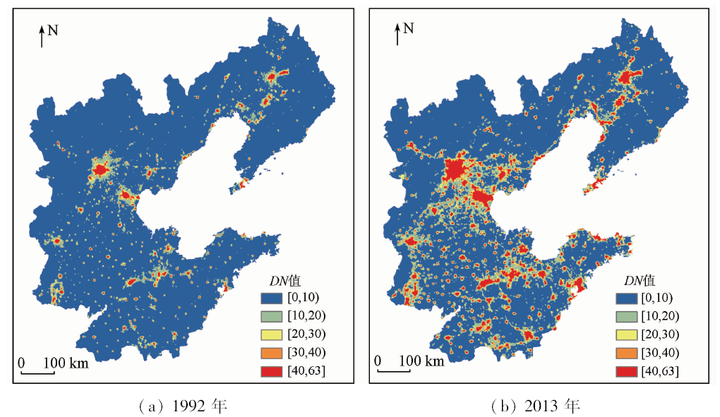
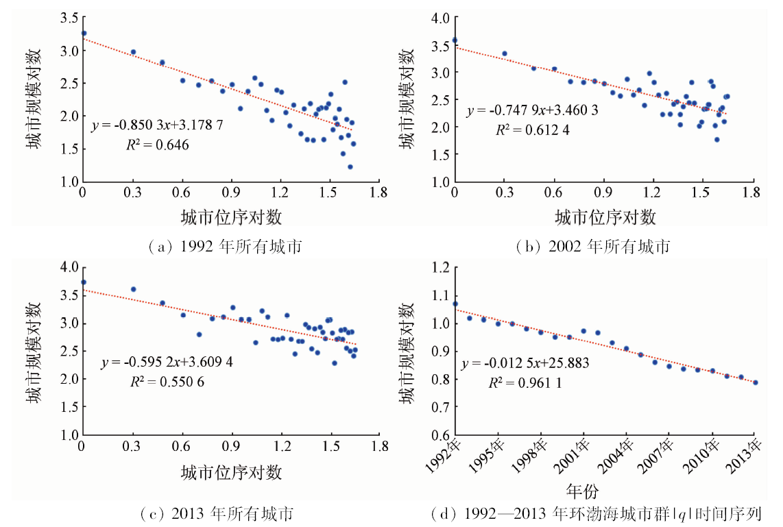
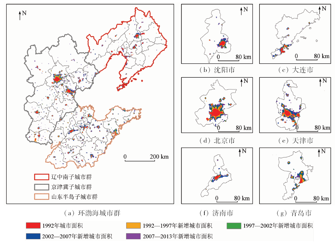
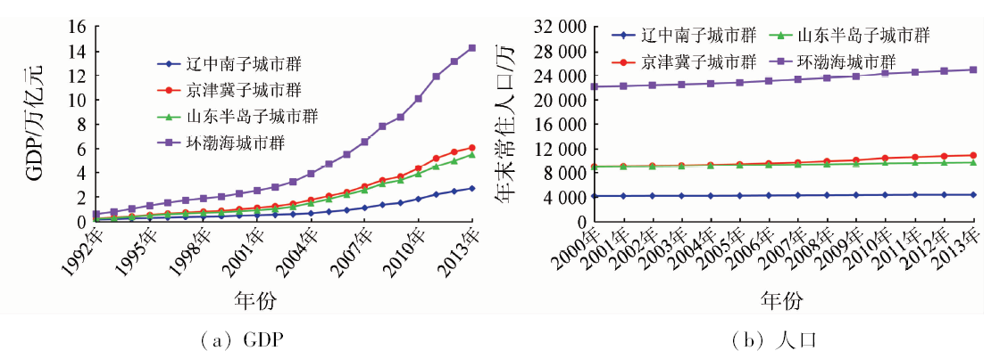
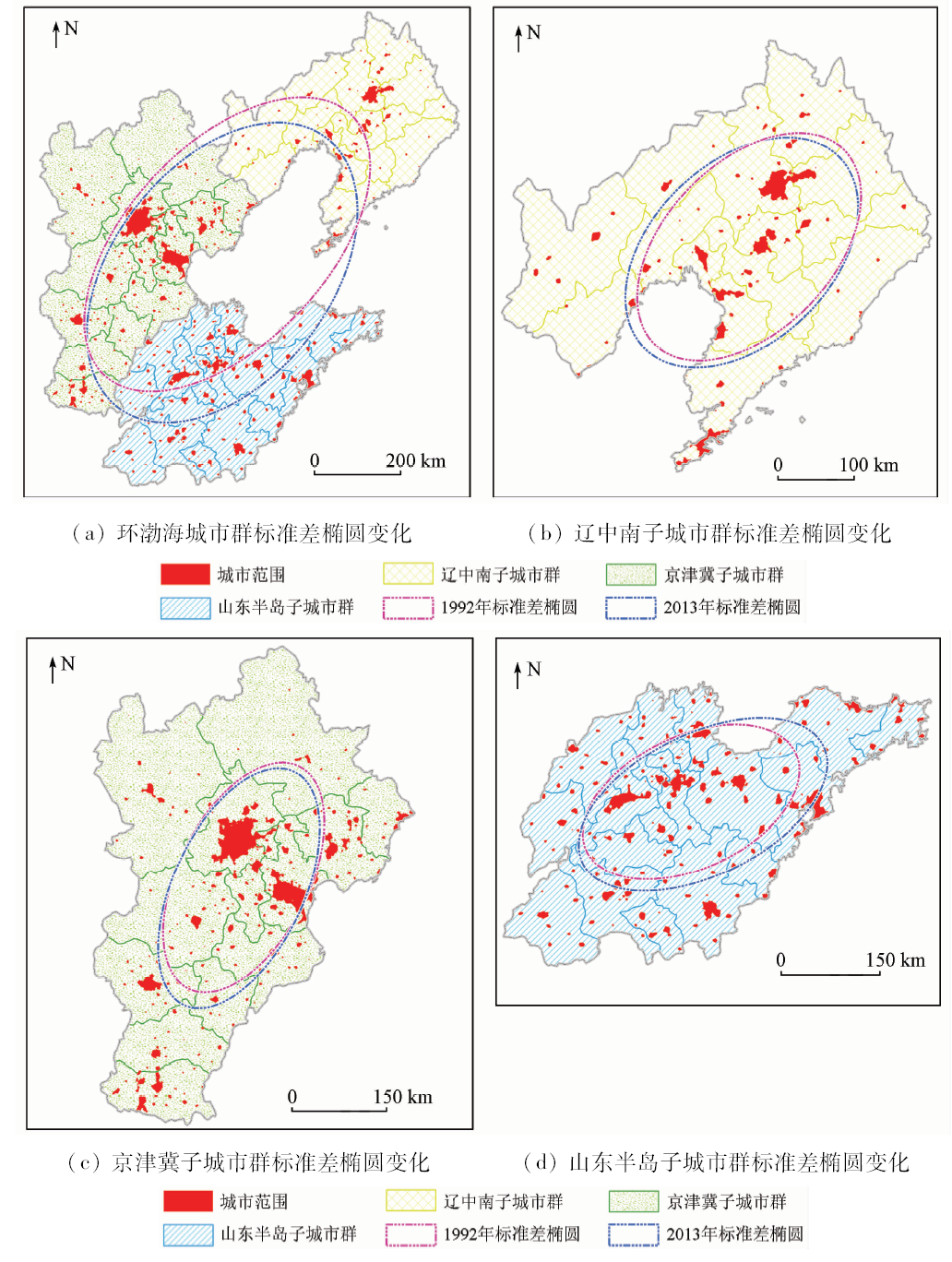
Abstract The study of the spatio-temporal evolution of urban agglomeration is of great importance for optimizing the spatial structure of urban agglomeration and promoting the coordinated development of cities. Taking the circum-Bohai urban agglomeration as a study case, the authors revealed the characteristics and objective law of urban evolution process from spatial and temporal dimensions. On the basis of DMSP/OLS night-time light data, the spatial distribution and area of urban from 1992 to 2013 were obtained for the circum-Bohai urban agglomeration. Using the rank-size rule model, the authors determined the size characteristics of urban area. Combined with urban spatial expansion speed index and standard deviation ellipsoid method, the intensity and spatial dynamics of urban area change were clarified in the circum-Bohai urban agglomeration. Some conclusions have been reached: (1) from 1992 to 2013, there was a significant increase of the total night-time lights in the circum-Bohai urban agglomeration, with the overall growth rate being 135.89%. (2) The effect of radiative driving effect of the central cities of the urban agglomeration on the surrounding areas gradually enhanced, and the distribution scale of the urban agglomeration changed from the unbalanced state to the equilibrium state with time. (3) The spatial expansion of the urban agglomeration was characterized by the ring stratification around central cities. The evolution pattern of the urban agglomeration was from west to east and from north to south, and its gravity center shifted to the southwest. It can be inferred that the driving force of the circum-Bohai urban agglomeration development was mainly concentrated in the coastal cities. The study can provide data supports and references for the coordinated development of the circum-Bohai urban agglomeration and even the whole country.
|
| Keywords
circum-Bohai urban agglomeration
DMSP/OLS night-time light data
rank-size rule
urban spatial expansion speed index
standard deviation ellipsoid
|
|
|
|
Issue Date: 03 December 2019
|
|
|
| [1] |
顾朝林 . 城市群研究进展与展望[J]. 地理研究, 2011,30(5):771-784.
doi: 10.11821/yj2011050001
url: http://d.wanfangdata.com.cn/Periodical/dlyj201105001
|
| [1] |
Gu Z L . Study on urban agglomeration progress and prospects[J]. Geographical Research, 2011,30(5):771-784.
|
| [2] |
Fang C L, Yu D L . Urban agglomeration:An evolving concept of an emerging phenomenon[J]. Landscape and Urban Planning, 2017,162:126-136.
|
| [3] |
吴建楠, 程绍铂, 姚士谋 . 中国城市群空间结构研究进展[J].现代城市研究,2013(12):97-101.
|
| [3] |
Wu J N, Chen S B, Yao S M . Review and prospect of research on spatial structure of China’s urban agglomerations[J].Modern City Research,2013(12):97-101.
|
| [4] |
倪愿, 周小成, 江威 . 结合Landsat数据的DMSP/OLS夜间灯光影像去饱和方法研究[J]. 遥感技术与应用, 2017,32(4):721-727.
|
| [4] |
Ni Y, Zhou X C, Jiang W . A reducing saturation method for DMSP/OLS nighttime light image combining Landsat data[J]. Remote Sensing Technology and Application, 2017,32(4):721-727.
|
| [5] |
柴宝惠, 李培军, 张瑞洁 , 等. 基于Landsat数据和DMSP/OLS夜间灯光数据的城市扩展提取:以天津市为例[J]. 北京大学学报(自然科学版), 2016,52(3):475-485.
doi: 10.13209/j.0479-8023.2015.138
|
| [5] |
Chai B H, Li P J, Zhang R J , et al. Urban expansion extraction using Landsat series data and DMSP/OLS nighttime light data:A case study of Tianjin area[J]. Acta Scientiarum Naturalium Universitatis Pekinensis, 2016,52(3):475-485.
|
| [6] |
耿丽英, 马明国 . 长时间序列NDVI数据重建方法比较研究进展[J]. 遥感技术与应用, 2014,29(2):362-368.
doi: 10.11873j.issn.1004-0323.2014.2.0362
|
| [6] |
Geng L Y, Ma M G . Advance in method comparison of reconstructing remote sensing time series data sets[J]. Remote Sensing Technology and Application, 2014,29(02):362-368.
|
| [7] |
杨眉, 王世新, 周艺 , 等. DMSP/OLS夜间灯光数据应用研究综述[J]. 遥感技术与应用, 2011,26(1):45-51.
|
| [7] |
Yang M, Wang S X, Zhou Y , et al. Review on applications of DMSP/OLS night-time emissions data[J]. Remote Sensing Technology and Application, 2011,26(1):45-51.
|
| [8] |
Castells-Quintana D . Malthus living in a slum:Urban concentration,infrastructure and economic growth[J]. Journal of Urban Economics, 2017,98:158-173.
|
| [9] |
李德仁, 余涵若, 李熙 . 基于夜光遥感影像的“一带一路”沿线国家城市发展时空格局分析[J]. 武汉大学学报(信息科学版), 2017,42(6):711-720.
|
| [9] |
Li D R, Yu H R, Li X . The spatial-temporal pattern analysis of city development in countries along the Belt and Road Initiative based on nighttime light data[J]. Geomatics and Information Science of Wuhan University, 2017,42(6):711-720.
|
| [10] |
Amaral S, Monteiro A M V, Camara G ,et al.DMSP/OLS night-time light imagery for urban population estimates in the Brazilian Amazon[J]. International Journal of Remote Sensing, 2006,27(5):855-870.
|
| [11] |
吴健生, 刘浩, 彭建 , 等. 中国城市体系等级结构及其空间格局——基于DMSP/OLS夜间灯光数据的实证[J]. 地理学报, 2014,69(6):759-770.
doi: 10.11821/dlxb201406004
url: http://www.geog.com.cn/CN/Y2014/V69/I6/759
|
| [11] |
Wu J S, Liu H, Peng J , et al. Hierarchical structure and spatial pattern of China’s urban system:Evidence from DMSP/OLS nightlight data[J]. Acta Geographica Sinica, 2014,69(6):759-770.
|
| [12] |
Huang Q X, He C Y, Gao B , et al. Detecting the 20 year city-size dynamics in china with a rank clock approach and DMSP/OLS nighttime data[J]. Landscape and Urban Planning, 2015,137:138-148.
|
| [13] |
韩向娣, 周艺, 王世新 , 等. 基于夜间灯光和土地利用数据的GDP空间化[J]. 遥感技术与应用, 2012,27(3):396-405.
|
| [13] |
Han X D, Zhou Y, Wang S X , et al. GDP Spatialization in China based on DMSP/OLS data and land use data[J]. Remote Sensing Technology and Application, 2012,27(3):396-405.
|
| [14] |
刘璐 . 基于夜间灯光数据的城市群蔓延指标[J]. 国土资源遥感, 2018,30(2):208-213.doi: 10.6046/gtzyyg.2018.02.28.
|
| [14] |
Liu L . Urban sprawl metrics based on night-time light data for metropolitan areas[J]. Remote sensing for land and resources, 2018,30(2):208-213.doi: 10.6046/gtzyyg.2018.02.28.
|
| [15] |
金梦, 邓顺强, 杨成术 , 等. 基于夜间灯光遥感数据多尺度城市聚类分析[J]. 遥感技术与应用, 2017,32(5):973-982.
|
| [15] |
Jin M, Deng S Q, Yang C S , et al. Multi-scale clustering analysis on China urban based on nighttime image[J]. Remote Sensing Technology and Application, 2017,32(5):973-982.
|
| [16] |
杨洋, 李雅静, 何春阳 , 等. 环渤海地区三大城市群城市规模分布动态比较——基于1992—2012年夜间灯光数据的分析和透视[J]. 经济地理, 2016,36(4):59-69.
|
| [16] |
Yang Y, Li Y J, He C Y , et al. A comparative study on spatiotemporal dynamics of city size distribution among three urban agglomerations in Bohai rim:Based on the analysis and perspective of nighttime light data from 1992 to 2012[J]. Economic Geography, 2016,36(4):59-69.
|
| [17] |
盖美, 张丽平, 田成诗 . 环渤海经济区经济增长的区域差异及空间格局演变[J]. 经济地理, 2013,33(4):22-28.
|
| [17] |
Gai M, Zhang L P, Tian C S . Economic development disparities and spatial pattern evolution in Bohai Sea economic zone[J]. Economic Geography, 2013,33(4):22-28.
|
| [18] |
王磊, 王琰琰, 张宇 . 城市土地利用效益与城市化耦合协调性分析——以环渤海地区27个城市为例[J]. 生态经济, 2017,33(5):25-28.
|
| [18] |
Wang L, Wang Y Y, Zhang Y . Coupling coordination degree of urban land use benefit and urbanization:A case of 27 cites in the Bohai rim region[J]. Ecological Economy, 2017,33(5):25-28.
|
| [19] |
王利伟, 冯长春 . 转型期京津冀城市群空间扩展格局及其动力机制——基于夜间灯光数据方法[J]. 地理学报, 2016,71(12):2155-2169.
doi: 10.11821/dlxb201612007
|
| [19] |
Wang L W, Feng C C . Spatial expansion pattern and its driving dynamics of Beijing-Tianjin-Hebei metropolitan region:Based on nighttime light data[J]. Acta Geographica Sinica, 2016,71(12):2155-2169.
|
| [20] |
何春阳, 李景刚, 陈晋 , 等. 基于夜间灯光数据的环渤海地区城市化过程[J]. 地理学报, 2005,60(3):409-417.
doi: 10.3321/j.issn:0375-5444.2005.03.007
url: http://d.wanfangdata.com.cn/Periodical_dlxb200503007.aspx
|
| [20] |
He C Y, Li J G, Chen J , et al. The urbanization model and process in Bohai Sea surrounding area in the 1990s by using DMSP/OLA data[J]. Acta Geographica Sinica, 2005,60(3):409-417.
|
| [21] |
曹子阳, 吴志峰, 匡耀求 , 等. DMSP/OLS夜间灯光影像中国区域的校正及应用[J]. 地球信息科学学报, 2015,17(9):1092-1102.
doi: 10.3724/SP.J.1047.2015.01092
|
| [21] |
Cao Z Y, Wu Z F, Kuang Y Q , et al. Correction of DMSP/OLS night-time light images and its application in China[J]. Journal of Geo-Information Science, 2015,17(9):1092-1102.
|
| [22] |
邹进贵, 陈艳华, 田径 , 等. 基于ArcGIS的DMSP/OLS夜间灯光影像校正模型的构建[J]. 测绘地理信息, 2014,39(4):33-37.
|
| [22] |
Zou J G, Chen Y H, Tian J , et al. Construction of the calibration model for DMSP/OLS nighttime light images based on ArcGIS[J]. Journal of Geomatics, 2014,39(4):33-37.
|
| [23] |
谈明洪, 吕昌河 . 以建成区面积表征的中国城市规模分布[J]. 地理学报, 2003,58(2):285-293.
doi: 10.3321/j.issn:0375-5444.2003.02.016
url: http://d.wanfangdata.com.cn/Periodical/dlxb200302016
|
| [23] |
Tan M H, Lyu C H . Distribution of China city size expressed by urban built-up area[J]. Acta Geographica Sinica, 2003,58(2):285-293.
|
| [24] |
郭建科, 陈园月, 于旭会 , 等. 1985年来环渤海地区港口体系位序——规模分布及作用机制[J]. 地理学报, 2017,72(10):1812-1826.
doi: 10.11821/dlxb201710007
|
| [24] |
Guo J K, Chen Y Y, Yu X H , et al. Rank-size distribution and mechanism of port system in the Bohai rim during the past thirty years[J]. Acta Geographica Sinica, 2017,72(10):1812-1826.
|
| [25] |
舒松, 余柏蒗, 吴健平 , 等. 基于夜间灯光数据的城市建成区提取方法评价与应用[J]. 遥感技术与应用, 2011,26(2):169-176.
|
| [25] |
Shu S, Yu B L, Wu J P , et al. Methods for deriving urban built-up area using night-light data:Assessment and application[J]. Remote Sensing Technology and Application, 2011,26(2):169-176.
|
| [26] |
王春杨, 吴国誉, 张超 . 基于DMSP/OLS夜间灯光数据的成渝城市群空间结构研究[J]. 城市发展研究, 2015,22(11):20-24.
|
| [26] |
Wang C Y, Wu G Y, Zhang C . Research on spatial structure of the Chengdu-Chongqing urban agglomeration based on the DMSP/OLS nighttime light data[J]. Urban Development Studies, 2015,22(11):20-24.
|
|
Viewed |
|
|
|
Full text
|
|
|
|
|
Abstract
|
|
|
|
|
Cited |
|
|
|
|
| |
Shared |
|
|
|
|
| |
Discussed |
|
|
|
|
 2019,
Vol. 31
2019,
Vol. 31