|
|
 |
|

|
|
|
Application of information value model based on symmetrical factors classification method in landslide hazard assessment |
LING Xiao1( ), LIU Jiamei2,3(), WANG Tao2,3, ZHU Yueqin4, YUAN Lingling4, CHEN Yangyang1 ), LIU Jiamei2,3(), WANG Tao2,3, ZHU Yueqin4, YUAN Lingling4, CHEN Yangyang1 |
1. School of Information Engineering and Technology, China University of Geosciences (Beijing), Beijing, 100083, China
2. Institute of Geomechanics, Chinese Academy of Geological Sciences, Beijing, 100081, China
3. Key Laboratory of Neotectonics Movement and Geohazard, Beijing, 100081, China
4. Development and Research Center, China Geological Survey, Beijing, 100037, China |
|
|
|
|
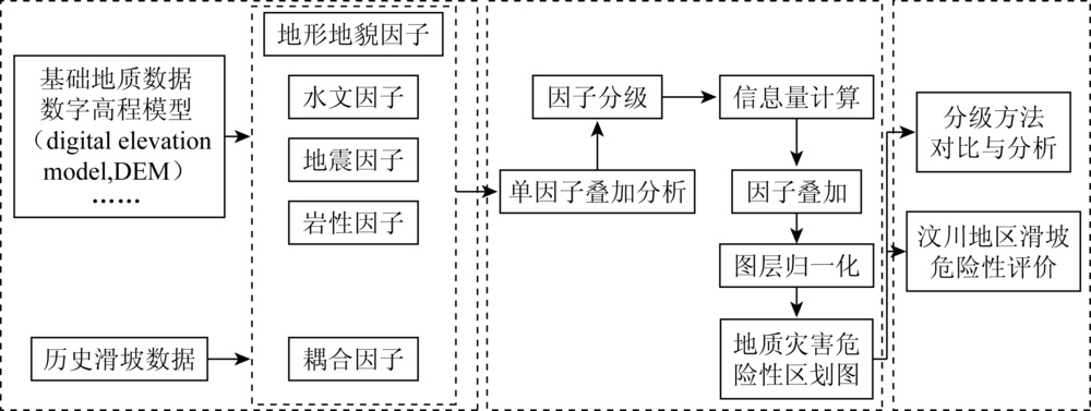
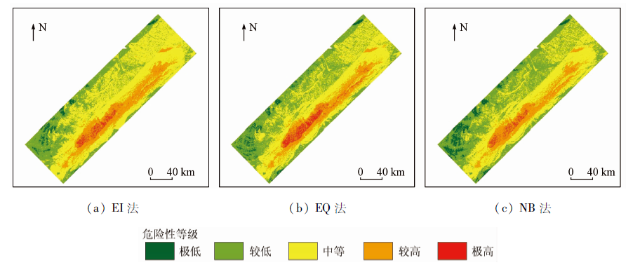
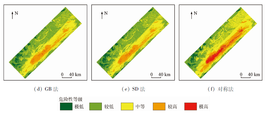
Abstract The information value model (IVM) is a statistical prediction method derived from information theory, which is widely used in natural hazard risk assessment. The problem as to how to formulate a suitable factor classification method to maximize the advantages of pre- single factor statistical analysis remains a key issue. In order to solve this problem, the authors processed a method of factor classification by combining symmetrical intervals. Statistical knowledge related to normal distribution was referred, the factors was pre-segmented by 1/2 standard deviation, and the intervals were merged symmetrically from outside to inside. After that, factors approximately fitting normal distribution, such as slope angel and topographic wetness index (TWI), were classified based on this method, and IVM was built, which was later used in landslide hazard susceptibility analysis in Wenchuan area. Meanwhile, 5 standard classification methods were selected and tested as comparative experiments for rationality verification, namely equal quantile (EQ) classification method, natural break (NB) classification method, geometric break (GB) classification method and standard deviation (SD) classification method. The results show that the IVM using symmetrical method as factor classification method stands out among the rests. The actual landslide area ratio in the high and extremely high-risk areas in the susceptibility map reached 80.87%, higher than that obtained by other standard classification methods. This proves that the symmetrical classification method performs well.
|
| Keywords
information value model (IVM)
landslide triggered by earthquake
landslide susceptibility analysis
factor classification methods
symmetrical classification method
|
|
|
|
Corresponding Authors:
LIU Jiamei
E-mail: LinGX0527@163.com;ljm19870918@126.com
|
|
Issue Date: 21 July 2021
|
|
|
| [1] |
张铎, 吴中海, 李家存, 等. 国内外地震滑坡研究综述[J]. 地质力学学报, 2013, 19(3):225-241.
|
| [1] |
Zhang D, Wu Z H, Li J C, et al. An overview on earthquake-included landslide research[J]. Journal of Geomechanics, 2013, 19(3):225-241.
|
| [2] |
刘凤民, 张立海, 刘海青, 等. 中国地震次生地质灾害危险性评价[J]. 地质力学学报, 2006, 12(2):127-131.
|
| [2] |
Liu F M, Zhang L H, Liu H Q, et al. Danger assessment of earthquake-included geological disasters in China[J]. Journal of Geomechanics, 2006, 12(2):127-131.
|
| [3] |
Pourghasemi H R, Pradhan B, Gokceoglu C. Application of fuzzy logic and analytical hierarchy process (AHP) to landslide susceptibility mapping at Haraz Watershed,Iran[J]. Natural Hazards, 2012, 63(2):965-996.
doi: 10.1007/s11069-012-0217-2
url: http://link.springer.com/10.1007/s11069-012-0217-2
|
| [4] |
刘丽娜, 许冲, 徐锡伟, 等. GIS支持下基于AHP方法的2013年芦山地震区滑坡危险性评价[J]. 灾害学, 2014(4):183-191.
|
| [4] |
Liu L N, Xu C, Xu X W, et al.GIS-based landslide hazard evaluation using AHP method in the 2013 Lushan earthquake region[J]. Journal of Catastrophology, 2014(4):183-191.
|
| [5] |
贺鹏, 童立强, 郭兆成, 等. GIS支持下基于层次分析法的西藏札达地区滑坡灾害危险性评价研究[J]. 科学技术与工程, 2016, 16(25):193-200.
|
| [5] |
He P, Tong L Q, Guo Z C, et al. Evaluation research on the landslide disaster liability in Zhada region of tibet[J]. Science Technology and Engineering, 2016, 16(25):193~200.
|
| [6] |
庄建琦, 崔鹏, 葛永刚, 等. 5·12汶川地震崩塌滑坡分布特征及影响因子评价——以都江堰至汶川公路沿线为例[J]. 地质科技情报, 2009, 28(2):16-22.
|
| [6] |
Zhuang J Q, Cui P, Ge Y G, et al. Distribution characteristics and impact factors assessment of collapses and landslides caused by 5.12 Wenchuan earthquake:Taking Dujiangyan-Wenchuan Highway as a sample[J]. Bulletin of Geological Science and Technology, 2009, 28(2):16-22.
|
| [7] |
He Y, Beighley R E. GIS-based regional landslide susceptibility mapping:A case study in southern California[J]. Earth Surface Processes & Landforms, 2010, 33(3):380-393.
|
| [8] |
Roberta P, Paolo F, Giuseppe S, et al. Landslide susceptibility assessment in Apulian southern Apennine:Heuristic vs.statistical method[J]. Environmental Earth Sciences, 2014, 72(4):1097-1108.
doi: 10.1007/s12665-013-3026-3
url: http://link.springer.com/10.1007/s12665-013-3026-3
|
| [9] |
Yilmaz I. Comparison of landslide susceptibility mapping methodologies for Koyulhisar,Turkey:Conditional probability,logistic regression,artificial neural networks and support vector machine[J]. Environmental Earth Sciences, 2010, 61(4):821-836.
doi: 10.1007/s12665-009-0394-9
url: http://link.springer.com/10.1007/s12665-009-0394-9
|
| [10] |
Youssef A M, Pourghasemi H R, Pourtaghi Z S, et al. Landslide susceptibility mapping using random forest,boosted regression tree,classification and regression tree and general linear models and comparison of their performance at Wadi Tayyah Basin,Asir region,Saudi Arabia[J]. Landslides, 2016, 13(5):839-856.
doi: 10.1007/s10346-015-0614-1
url: http://link.springer.com/10.1007/s10346-015-0614-1
|
| [11] |
Wei C, Xie X S, Peng J B, et al. GIS-based landslide susceptibility evaluation using a novel hybrid integration approach of bivariate statistical based random forest method[J]. Catena, 2018, 164(5):135-149.
doi: 10.1016/j.catena.2018.01.012
url: https://linkinghub.elsevier.com/retrieve/pii/S0341816218300122
|
| [12] |
丛威青, 潘懋, 李铁锋, 等. 基于GIS的滑坡、泥石流灾害危险性区划关键问题研究[J]. 地学前缘, 2006, 13(1):185-190.
|
| [12] |
Cong W Q, Pan M, Li T F, et al. Key research on landslide and debris flow hazard zonation based on GIS[J]. Earth Science Frontiers, 2006, 13(1):185-190.
|
| [13] |
Shannon C E. A mathematical theory of communication[J]. The Bell System Technical Journal, 1948, 27(8):623-656.
doi: 10.1002/bltj.1948.27.issue-4
url: http://doi.wiley.com/10.1002/bltj.1948.27.issue-4
|
| [14] |
Van W C. Statistical landslide hazard analysis[C]// Application Guide.ILWIS 21 for Windows.Enschede:ITC, 1997:73-84.
|
| [15] |
杜军, 杨青华, 严嘉, 等. 基于GIS与信息量模型的汶川次生地质灾害危险性评价[J]. 地球科学-中国地质大学学报, 2010, 35(2):168-174.
|
| [15] |
Du J, Yang Q H, Yan J, et al. Hazard evaluation of secondary geological disaster based on GIS and information value method[J]. Editorial Committee of Earth Science,Journal of China University of Geosciences, 2010, 35(2):168-174.
|
| [16] |
罗真富. 泥石流流域滑坡地质灾害遥感信息提取及危险性评价——以安县段和松潘段研究区为例[D]. 成都:成都理工大学, 2011.
|
| [16] |
Luo Z F. Landslide hazard evaluation in debris flow catchment area based on GIS and information method[D]. Chengdu:Chengdu Univerisity of Technology, 2011.
|
| [17] |
Afungang R N, Valdir D M B C, Nkwemoh C A, Assessing the spatial probability of landslides using GIS and informative value model in the Bamenda highlands[J]. Arabian Journal of Geosciences, 2017, 10(17):384-399.
doi: 10.1007/s12517-017-3155-1
url: http://link.springer.com/10.1007/s12517-017-3155-1
|
| [18] |
Laxmi D V, Rajeshwar B, Desh D P. Comparative evaluation of GIS based landslide hazard zonation maps using different approaches[J]. Journal of the Geological Society of India, 2019, 93(6):684-692.
doi: 10.1007/s12594-019-1247-0
url: https://doi.org/10.1007/s12594-019-1247-0
|
| [19] |
Chen Y, Wang Q, Wei Y, et al. Application of information index model in landslide susceptibility mapping on Tonggu Jiangxi province,China[C]// IGARSS IEEE International Geoscience & Remote Sensing Symposium,IEEE, 2014.
|
| [20] |
殷坤龙. 滑坡灾害预测预报[M]. 北京: 中国地质大学出版社, 2004.
|
| [20] |
Yin K L. Forecast of landslide hazard[M]. Beijing: China University of Geosciences Press, 2004.
|
| [21] |
许冲, 徐锡伟, 吴熙彦, 等. 2008年汶川地震滑坡详细编目及其空间分布规律分析[J]. 工程地质学报, 2013, 21(1):27-46.
|
| [21] |
Xu C, Xu X W, Wu X Y, et al. Detailed catalog of landslides triggered by the 2008 Wenchuan earthquake and statistical analyses of their spatial distribution[J]. Journal of Engineering Geology, 2013, 21(1):27-46.
|
| [22] |
兰恒星, 伍法权, 周成虎, 等. 基于GIS的滑坡空间数据库研究——以云南小江流域为例[J]. 中国地质灾害与防治学报, 2002, 13(4):10-16.
|
| [22] |
Lan H X, Wu F Q, Zhou C H, et al. GIS based spatial database for landslide assessment——A case study in Yunnan Xiaojiang river valley[J]. The Chinese Journal of Geological Hazard and Control, 2002, 13(4):10-16.
|
| [23] |
孟祥瑞, 裴向军, 刘清华, 等. GIS支持下基于因子分析法的都汶路沿线地质灾害易发性评价[J]. 中国地质灾害与防治学报, 2016, 27(3):112-121.
|
| [23] |
Meng X R, Pei X J, Liu Q H, et al. GIS-based susceptibility assessment of geological hazards along the road from Dujiangyan to Wenchuan by factor analysis[J]. The Chinese Journal of Geological Hazard and Control, 2016, 27(3):112-121.
|
| [24] |
许冲, 戴福初, 姚鑫, 等. 基于GIS的汶川地震滑坡灾害影响因子确定性系数分析[C]// 中国科学院地质与地球物理研究所第十届(2010年度)学术年会论文集(中), 2011.
|
| [24] |
Xu C, Dai F C, Yao X, et al. Earthquake triggered landslide susceptibility evaluation based on GIS platform and weight-of-evidence modeling[C]// Proceedings of the 10th (2010) Annual Conference of the Institute of Geology and Geophysics, Chinese Academy of Sciences, 2011.
|
| [25] |
孙德亮. 基于机器学习的滑坡危险性区划与降雨诱发滑坡预报预警研究[D]. 上海:华东师范大学, 2019.
|
| [25] |
Sun D L. Mapping landslide susceptibility based on machine learning and forecast warning of landslide induced by rainfall[D]. Shanghai:East China Normal University, 2019.
|
| [26] |
赵卫东, 龚俊豪, 赵纪堂, 等. 顾及平原区微地貌的地形湿度指数及其地表水环境意义[J]. 合肥工业大学学报(自然科学版), 2019, 42(1):119-124.
|
| [26] |
Zhao W D, Gong J H, Zhao J T, et al. Research on topographic wetness index and its implications of surface water environment considering micro-reliefs on plains[J]. Journal of Hefei University of Technology(Natural Science), 2019, 42(1):119-124.
|
| [27] |
陶舒, 胡德勇, 赵文吉, 等. 基于信息量与逻辑回归模型的次生滑坡灾害敏感性评价——以汶川县北部为例[J]. 地理研究, 2010, 29(9):60-71.
|
| [27] |
Tao S, Hu D Y, Zhao W J, et al. Susceptibility assessment of secondary landslides triggered by earthquakes:A case study of northern Wenchuan[J]. Geographical Research, 2010, 29(9):60-71.
|
|
Viewed |
|
|
|
Full text
|
|
|
|
|
Abstract
|
|
|
|
|
Cited |
|
|
|
|
| |
Shared |
|
|
|
|
| |
Discussed |
|
|
|
|
 2021,
Vol. 33
2021,
Vol. 33