|
|
|
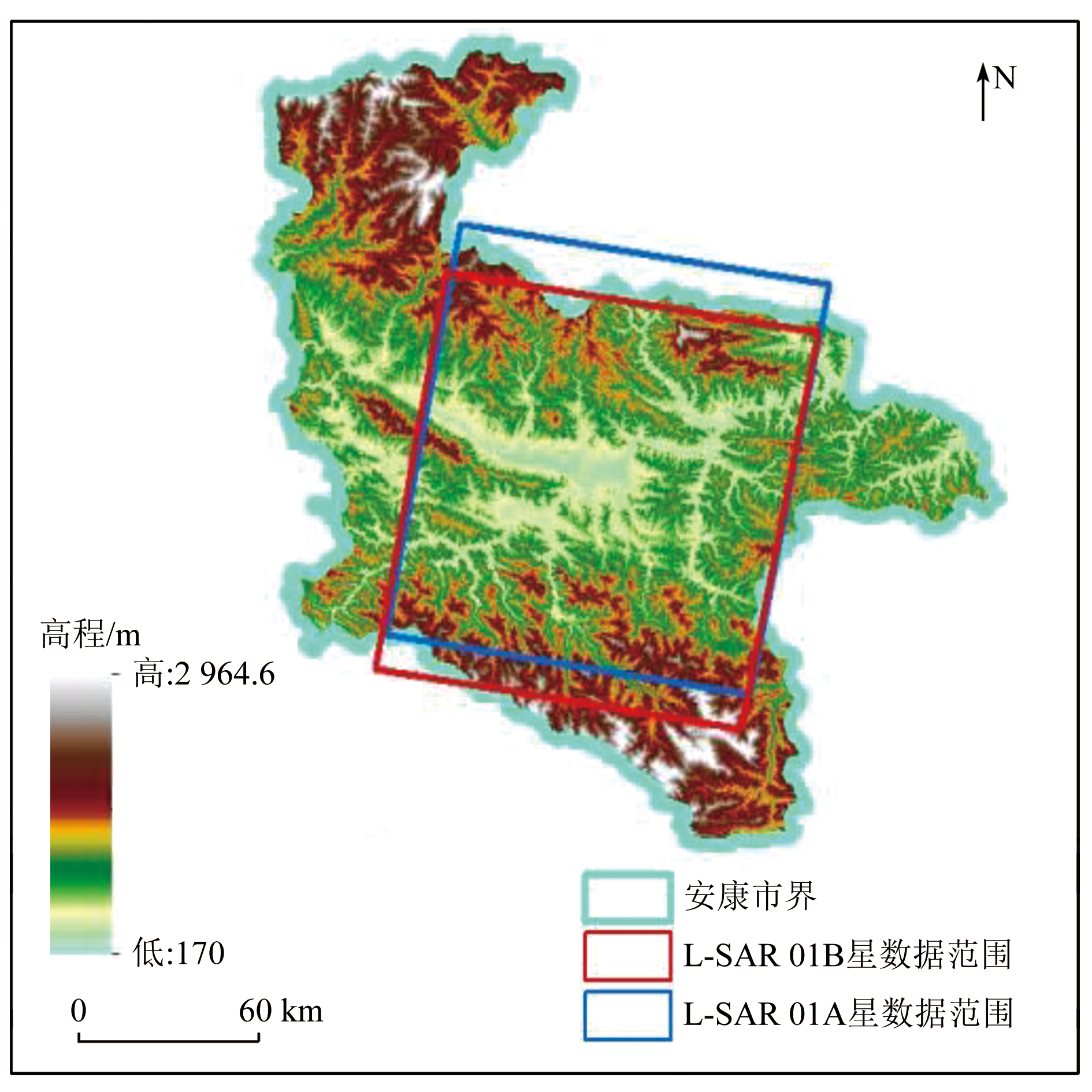
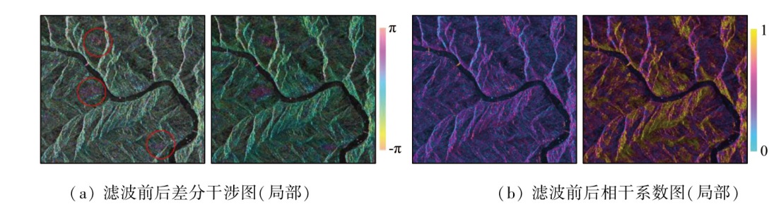
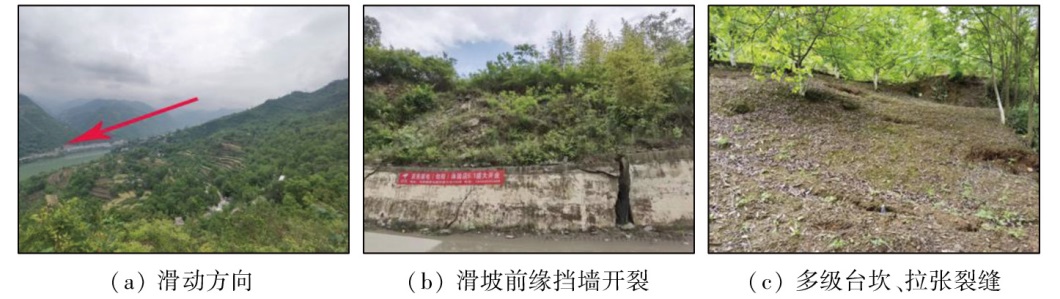
Abstract On April 1, 2023, China’s first satellite constellation-L-band differential interferometric Synthetic Aperture Radar (L-SAR)-began to test the distribution of interferometric SAR data for natural resource applications. To evaluate the coherence and effectiveness of deformation monitoring using the L-SAR satellite for areas with high vegetation coverage, complex terrain, and long-term baseline, this study conducted potential landslide hazard identification in the Ankang area in the eastern Qinba Mountain. The deformation information of the study area was extracted using L-SAR data. Using such information, combined with high-resolution optical images for comprehensive remote sensing identification, this study identified seven potential landslide hazards in the study area through interpretation. Field investigation confirmed that the observed deformation signs in potential landslide hazard areas were consistent with the InSAR monitoring results. The study indicates that the L-SAR satellite enjoys a high interference imaging ability, high imaging quality, and effective deformation monitoring, meeting the demand for deformation monitoring in areas with high vegetation coverage. For mountainous areas with high vegetation coverage, the use of L-band SAR data through DInSAR technology, combined with comprehensive remote sensing identification using high-resolution optical imagery, allows for the effective identification of potential landslide hazards.
|
| Keywords
L-SAR
landslide
potential geological hazard
InSAR
|
|
|
|
Issue Date: 23 December 2024
|
|
|
| [1] |
Li T, Tang X M, Zhou X Q, et al. Lutan-1 SAR main applications and products[C]. EUSAR, 2022:25-27.
|
| [2] |
李振洪, 朱武, 余琛, 等. 雷达影像地表形变干涉测量的机遇、挑战与展望[J]. 测绘学报, 2022, 51(7):1485-1519.
doi: 10.11947/j.AGCS.2022.20220224
|
| [2] |
Li Z H, Zhu W, Yu C, et al. Interferometric synthetic aperture radar for deformation mapping:Opportunities,challenges and the outlook[J]. Acta Geodaetica et Cartographica Sinica, 2022. 51(7):1485-1519.
|
| [3] |
安康市人民政府办公室. 安康市2022年度地质灾害防治方案[EB/OL](2022-04-29)[2023-05-26]. https://www.ankang.gov.cn/UploadFiles/file/20220708/20220708092614_3379.pdf.
url: https://www.ankang.gov.cn/UploadFiles/file/20220708/20220708092614_3379.pdf
|
| [3] |
Office of Ankang Municipal People’s Government. Ankang City’s 2022 geological disaster prevention and control plan[EB/OL] 2022-04-29)[2023-05-26]. https://www.ankang.gov.cn/UploadFiles/file/20220708/20220708092614_3379.pdf.
url: https://www.ankang.gov.cn/UploadFiles/file/20220708/20220708092614_3379.pdf
|
| [4] |
葛大庆, 戴可人, 郭兆成, 等. 重大地质灾害隐患早期识别中综合遥感应用的思考与建议[J]. 武汉大学学报(信息科学版), 2019, 44(7):949-956.
|
| [4] |
Ge D Q, Dai K R, Guo Z C, et al. Early identification of serious geological hazards with integrated remote sensing technologies:Thoughts and recommendations[J]. Geomatics and Information Science of Wuhan University, 2019, 44(7):949-956.
|
| [5] |
许强. 对地质灾害隐患早期识别相关问题的认识与思考[J]. 武汉大学学报(信息科学版), 2020, 45(11):1651-1659.
|
| [5] |
Xu Q. Understanding and consideration of related issues in early identification of potential geohazards[J]. Geomatics and Information Science of Wuhan University, 2020, 45(11):1651-1659.
|
| [6] |
吴绿川, 王剑辉, 符彦. 基于InSAR技术和光学遥感的贵州省滑坡早期识别与监测[J]. 测绘通报, 2021(7):98-102.
doi: 10.13474/j.cnki.11-2246.2021.0216
|
| [6] |
Wu L C, Wang J H, Fu Y. Early identifying and monitoring landslides in Guizhou Province with InSAR and optical remote sensing[J]. Bulletin of Surveying and Mapping, 2021(7):98-102.
doi: 10.13474/j.cnki.11-2246.2021.0216
|
| [7] |
张家勇, 邹银先, 刘黔云, 等. 利用时序InSAR进行毕节市潜在滑坡识别与形变监测[J]. 测绘通报, 2022(6):121-124.
doi: 10.13474/j.cnki.11-2246.2022.0183.
|
| [7] |
Zhang J Y, Zou Y X, Liu Q Y, et al. Potential landslides deformation monitoring in Bijie City with InSAR time series[J]. Bulletin of Surveying and Mapping, 2022,(6):121-124.
doi: 10.13474/j.cnki.11-2246.2022.0183.
|
| [8] |
苏晓军, 张毅, 贾俊, 等. 基于InSAR技术的秦岭南部略阳县潜在滑坡灾害识别研究[J]. 山地学报, 2021, 39(1):59-70.
|
| [8] |
Su X J, Zhang Y, Jia J, et al. InSAR-based monitoring and identification of potential landslides in Lueyang County,the southern Qinling Mountains,China[J]. Mountain Research, 2021, 39(1):59-70.
|
| [9] |
郑治国, 郭俊理, 李平录. 基于GIS的陕西省安康市地质灾害易发性分区[J]. 湖北农业科学, 2020, 59(3):53-57.
|
| [9] |
Zheng Z G, Guo J L, Li P L. GIS-based zoning of geological hazard’s susceptibility in Ankang City of Shaanxi Province[J]. Hubei AgriculturalSciences, 2020, 59(3):53-57.
|
| [10] |
王伟, 陈帆, 金涛. 安康市汉滨区地质灾害发育成因及评价[J]. 陕西地质, 2020, 38(1):71-78.
|
| [10] |
Wang W, Chen F, Jin T. Genesis and evaluation of geologica lhazards in Hanbin District of Ankang City[J]. Geology of Shaanxi, 2020, 38(1):71-78.
|
| [11] |
Li T, Tang X M, Zhou X Q, et al. Deformation products of Lutan-1(LT-1)SAR satellite constellation for geohazard monitoring[C]. IGARSS, 2022:17-22.
|
| [12] |
李涛, 唐新明, 李世金, 等. L波段差分干涉SAR卫星基础形变产品分类[J]. 测绘学报, 2023, 52(5):769-779.
doi: 10.11947/j.AGCS.2023.20220050
|
| [12] |
Li T, Tang X M, Li S J, et al. Classification of basic deformation products of L-band differential interlerometric SAR satellite[J]. Acta Geodaetica et Cartographica Sinica, 2023, 52(5):769-779.
|
| [13] |
刘晓帅, 陶秋香, 牛冲, 等. DInSAR与SBAS InSAR矿区地面沉降监测能力对比分析与验证[J]. 地球物理学进展, 2022, 37(5):1825-1833.
|
| [13] |
Liu X S, Tao Q X, Niu C, et al. 2022. Comparative analysis and veri-fication of DInSAR and SBAS InSAR in mining subsidence monitoring[J]. Progress in Geophysics, 37(5):1825-1833.
|
| [14] |
韩建锋, 焦润成, 南赟, 等. 基于D-InSAR技术的泸定地震形变场提取与震后灾害防治[J]. 城市地质, 2023, 18(1):104-109.
|
| [14] |
Han J F, Jiao R C, Nan Y, et al. D-InSAR deformation field extraction for an earthquake in Luding,Sichuan[J]. Urban Geology, 2023, 18(1)104-109.
|
| [15] |
李振洪, 李鹏, 丁咚, 等. 全球高分辨率数字高程模型研究进展与展望[J]. 武汉大学学报(信息科学版), 2018, 43(12):1927-1942.
|
| [15] |
Li Z H, Li P, Ding D, et al. Research progress of global high resolution digital elevation models[J]. Geomatics and Information Science of Wuhan University, 2018, 43(12):1927-1942.
|
| [16] |
董继红, 马志刚, 梁京涛, 等. 基于时序InSAR技术的滑坡隐患识别对比研究[J]. 自然资源遥感, 2022, 34(3):73-81.doi:10.6046/zzyyg.2121333.
|
| [16] |
Dong J H, Ma Z G, Liang J T, et al. Comparative study of landslide hidden danger ldentification based on time-series InSAR technology[J]. Remote Sensing for Natural Resources, 2022, 34(3):73-81.doi:10.6046/zzyyg.2121333.
|
|
Viewed |
|
|
|
Full text
|
|
|
|
|
Abstract
|
|
|
|
|
Cited |
|
|
|
|
| |
Shared |
|
|
|
|
| |
Discussed |
|
|
|
|
 2024,
Vol. 36
2024,
Vol. 36
 ), YANG Shuai, YANG Tao, ZHU Nannan, MA Yudong, ZHANG Wenlong(