|
|
 |
|

|
|
|
Spatial variability and influencing factors of LST in plateau area: Exemplified by Sangzhuzi District |
Junnan XIONG1,2, Wei LI1, Weiming CHENG2( ), Chunkun FAN3, Jin LI1, Yunliang ZHAO1 ), Chunkun FAN3, Jin LI1, Yunliang ZHAO1 |
1.School of Civil Engineering and Architecture, Southwest Petroleum University, Chengdu 610500, China
2.State Key Laboratory of Resources and Environmental Information System, Institute of Geographic and Natural Resources Research, Chinese Academy of Sciences, Beijing 100101, China
3.Agriculture Research Institute, Tibet Academy of Agriculture and Animal Husbandry Sciences, Lhasa 850000, China |
|
|
|
|
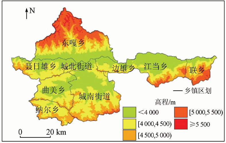
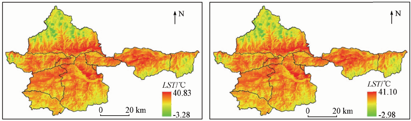
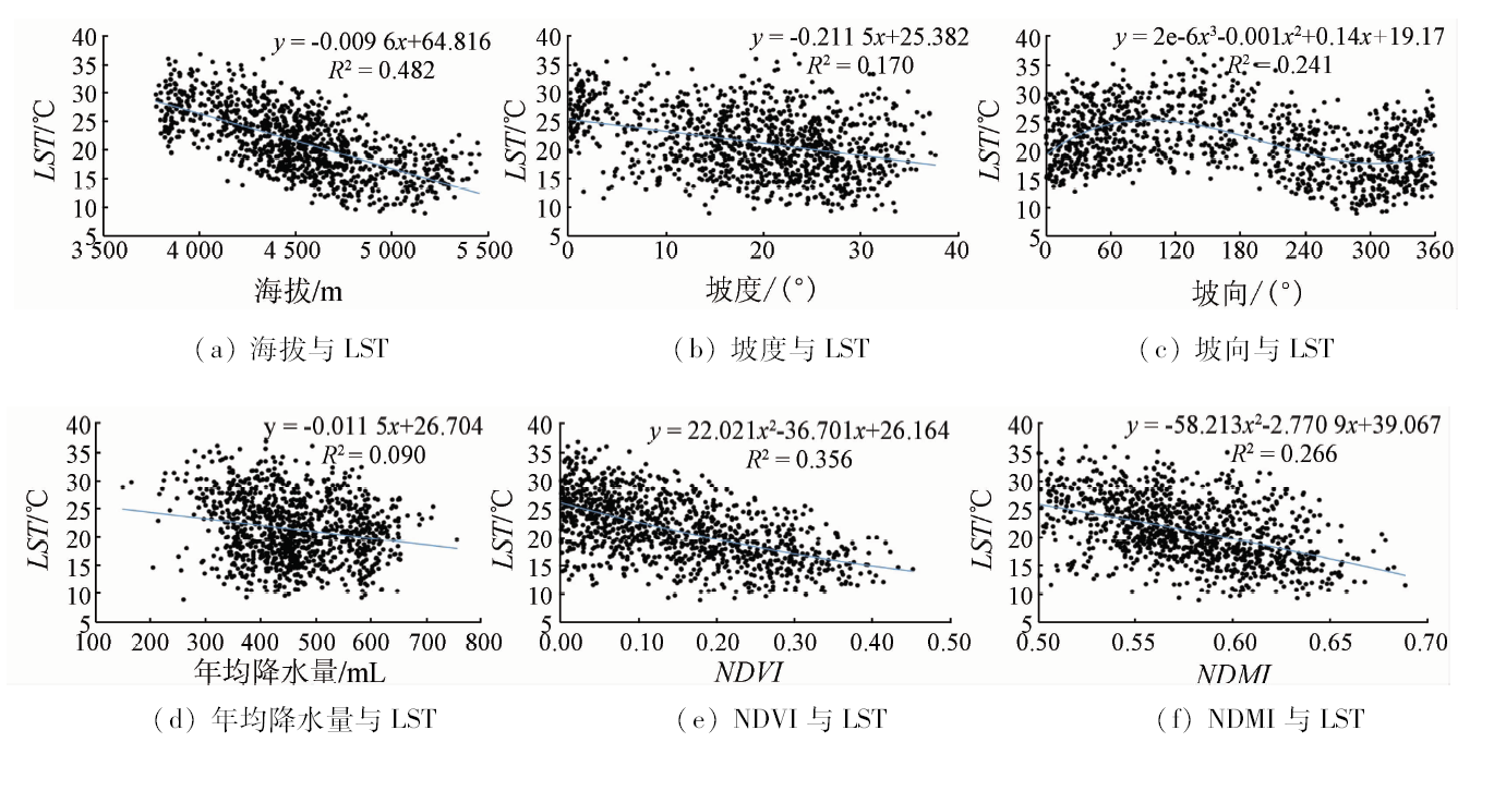
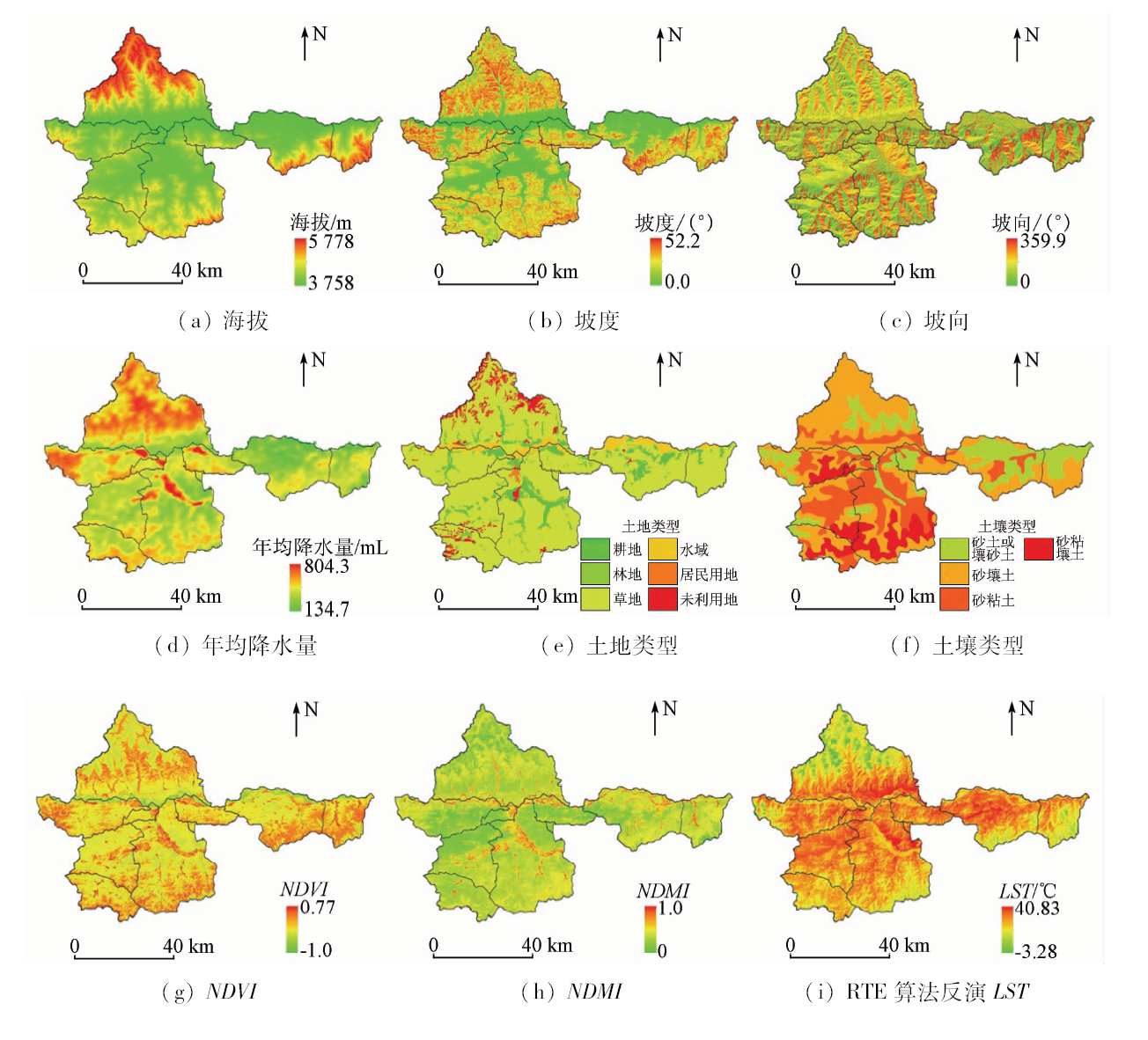
Abstract Revealing the spatial differentiation characteristics and influencing factors of land surface temperature (LST) in the plateau area is of great significance for the study of local climate change. However, the existing research merely analyzes the relationship between single factor and LST, whereas the study of the spatial differentiation characteristics and the quantitative analysis of influencing factors of LST in the plateau area are relatively insufficient. Taking the Sangzhuzi District of Xigaze City as an example, the authors used Landsat8 remote sensing data to invert the LST of the study area by using radiative transfer equation algorithm and the universal single-channel algorithm. In addition, the factor detector and interaction detector in the geodetector model were used to quantitatively detect the influence of single factor and multiple factors on LST, respectively. The results show that, in the quantifiable factors, LST increases first and then decreases with the increase in the degree of aspect, and there is a significant negative correlation between LST and other factors with a difference in the descent speed. Elevation is the most important factor affecting the spatial distribution and forming the differentiation characteristics of LST in the plateau area, followed by normalized difference vegetation index(NDVI), aspect, normalized difference moisture index(NDMI), soil type, slope, and average annual precipitation; the spatial distribution and the formation of differentiation characteristics of LST in the plateau area are the result of multiple factors, all of which have a synergistic enhancement effect under interactions, such as the interaction of elevation and aspect, elevation and NDMI, and elevation and NDVI with the most significant impact.
|
| Keywords
Landsat8
plateau region
land surface temperature(LST)
influence factors
geographical detector
|
|
|
|
Corresponding Authors:
Weiming CHENG
E-mail: chengwm@lreis.ac.cn
|
|
Issue Date: 23 May 2019
|
|
|
| [1] |
Scarano M, Sobrino J A . On the relationship between the sky view factor and the land surface temperature derived by Landsat-8 images in Bari,Italy[J]. International Journal of Remote Sensing, 2015,36(19-20):4820-4835.
doi: 10.1080/01431161.2015.1070325
url: https://www.tandfonline.com/doi/full/10.1080/01431161.2015.1070325
|
| [2] |
Rosca C F, Harpa G V, Croitoru A E, et al. The impact of climatic and non-climatic factors on land surface temperature in southwestern Romania[J]. Theoretical and Applied Climatology, 2016,130(3-4):1-16.
|
| [3] |
Kerchove R V D, Lhermitte S, Veraverbeke S , et al. Spatio-temporal variability in remotely sensed land surface temperature,and its relationship with physiographic variables in the Russian Altay Mountains[J]. International Journal of Applied Earth Observation and Geoinformation, 2013,20(2):4-19.
doi: 10.1016/j.jag.2011.09.007
url: https://linkinghub.elsevier.com/retrieve/pii/S0303243411001280
|
| [4] |
段金龙, 张学雷 . 区域地表水体、归一化植被指数与热环境多样性格局的关联分析[J]. 应用生态学报, 2012,23(10):2812-2820.
url: http://med.wanfangdata.com.cn/Paper/Detail/PeriodicalPaper_yystxb201210026
|
| [4] |
Duan J L, Zhang X L . Correlative analysis of the diversity patterns of regional surface water,NDVI and thermal environment[J]. Chinese Journal of Applied Ecology, 2012,23(10):2812-2820.
|
| [5] |
李润林, 时永杰, 姚艳敏 , 等. 基于LandsatTM/ETM+的张掖市甘州区绿洲冷岛效应时空变化研究[J]. 干旱区资源与环境, 2014,28(9):139-144.
|
| [5] |
Li R L, Shi Y J, Yao Y M , et al. Temporal and spatial variation of oasis cold island effect in Ganzhou District of Zhangye based on Landsat TM /ETM+[J]. Journal of Arid Land Resources and Environment, 2014,28(9):139-144.
|
| [6] |
钱乐祥, 崔海山 . 归一化水汽指数与地表温度的关系[J]. 地理研究, 2008,27(6):1358-1366.
|
| [6] |
Qian L X, Cui H S . Relationship between normalized difference moisture index and land surface temperature[J]. Geographical Research, 2008,27(6):1358-1366.
|
| [7] |
文路军, 彭文甫, 杨华容 , 等. 夏季川西高原地表温度的空间特征和影响因素——以西昌市大部分区域为例[J]. 国土资源遥感, 2017,29(2):207-214.doi: 10.6046/gtzyyg.2017.02.30.
|
| [7] |
Wen L J, Peng W F, Yang H R , et al. An analysis of land surface temperature(LST) and its influencing factors in summer in western Sichuan Plateau:A case study of Xichang City[J]. Remote Sensing for Land and Resources, 2017,29(2):207-214.doi: 10.6046/gtzyyg.2017.02.30.
|
| [8] |
孙常峰, 孔繁花, 尹海伟 , 等. 山区夏季地表温度的影响因素——以泰山为例[J]. 生态学报, 2014,34(12):3396-3404.
doi: <a href='http://dx.doi.org/10.5846/stxb201310312626'>10.5846/stxb201310312626</a>
|
| [8] |
Sun C F, Kong F H, Yin H W , et al. Analysis of factors affecting mountainous land surface temperature in the summer:A case study over Mount Tai[J]. Acta Ecologica Sinica, 2014,34(12):3396-3404.
|
| [9] |
张勇, 余涛, 顾行发 , 等. CBERS-02 IRMSS热红外数据地表温度反演及其在城市热岛效应定量化分析中的应用[J]. 遥感学报, 2006,10(5):789-797.
doi: 10.3321/j.issn:1007-4619.2006.05.028
url: http://d.wanfangdata.com.cn/Periodical/ygxb200605028
|
| [9] |
Zhang Y, Yu T, Gu X F , et al. Land surface temperature retrieval from CBERS-02 IRMSS thermal infrared data and its applications in quantitative analysis of urban heat island effect[J]. Journal of Remote Sensing, 2006,10(5):789-797.
|
| [10] |
Jiménez-Muñoz J C, Sobrino J A . A generalized single-channel method for retrieving land surface temperature from remote sensing data[J]. Journal of Geophysical Research Atmospheres, 2003,108(d22):4688-4695.
|
| [11] |
Jiménez-Muñoz J C, Sobrino J A , Skoković D , et al. Land surface temperature retrieval methods from Landsat-8 thermal infrared sensor data[J]. IEEE Geoscience and Remote Sensing Letters, 2014,11(10):1840-1843.
doi: 10.1109/LGRS.2014.2312032
url: http://ieeexplore.ieee.org/document/6784508/
|
| [12] |
王劲峰, 徐成东 . 地理探测器:原理与展望[J]. 地理学报, 2017,72(1):116-134.
|
| [12] |
Wang J F, Xu C D . Geodetector:Principle and prospective[J]. Acta Geographica Sinica, 2017,72(1):116-134.
|
| [13] |
Wang J F, Hu Y . Environmental health risk detection with Geodetector[J]. Environmental Modelling and Software, 2012,33:114-115.
doi: 10.1016/j.envsoft.2012.01.015
url: https://linkinghub.elsevier.com/retrieve/pii/S1364815212000333
|
| [14] |
熊俊楠, 赵云亮, 程维明 , 等. 四川省山洪灾害时空分布规律及其影响因素研究[J]. 地球信息科学学报, 2018,20(10):1443-1456.
url: http://www.cnki.com.cn/Article/CJFDTotal-DQXX201810010.htm
|
| [14] |
Xiong J N, Zhao Y L, Cheng W M , et al. Temporal-spatial distribution and the influencing factors of mountain flood disasters in Sichuan Province[J]. Journal of Geo-Information Science, 2018,20(10):1443-1456.
|
| [15] |
徐秋蓉, 郑新奇 . 一种基于地理探测器的城镇扩展影响机理分析法[J]. 测绘学报, 2015,44(s1):96-101.
|
| [15] |
Xu Q R, Zheng X Q . Analysis of influencing mechanism of urban growth using geographical detector[J]. Acta Geodaetica et Cartographica Sinica, 2015,44(s1):96-101.
|
| [16] |
李华威, 万庆 . 小流域山洪灾害危险性分析之降雨指标选取的初步研究[J]. 地球信息科学学报, 2017,19(3):425-435.
|
| [16] |
Li H W, Wan Q . Study on rainfall index selection for hazard analysis of mountain torrents disaster of small watersheds[J]. Journal of Geo-Information Science, 2017,19(3):425-435.
|
| [17] |
马伟, 赵珍梅, 刘翔 , 等. 植被指数与地表温度定量关系遥感分析——以北京市TM数据为例[J]. 国土资源遥感, 2010,22(4):108-112.doi: 10.6046/gtzyyg.2010.04.22.
doi: 10.6046/gtzyyg.2010.04.22
|
| [17] |
Ma W, Zhao Z M, Liu X , et al. A quantitative analysis of the relationship between vegetation indices and land surface temperature based on remote sensing:A case study of TM data for Beijing[J]. Remote Sensing for Land and Resources, 2010,22(4):108-112.doi: 10.6046/gtzyyg.2010.04.22.
|
| [18] |
杜培军, 陈宇, 谭琨 . 江苏滨海湿地土地利用/覆盖变化与地表温度响应遥感监测[J]. 国土资源遥感, 2014,26(2):112-120.doi: 10.6046/gtzyyg.2014.02.22.
doi: 10.6046/gtzyyg.2014.02.19
|
| [18] |
Du P J, Chen Y, Tan K . The remote sensing monitoring of land use/cover change and land surface temperature responses over the coastal wetland in Jiangsu[J]. Remote Sensing for Land and Resources, 2014,26(2):112-120.doi: 10.6046/gtzyyg.2014.02.22.
|
| [19] |
姚宜斌, 雷祥旭, 张良 , 等. 青藏高原地区1979—2014年大气可降水量和地表温度时空变化特征分析[J]. 科学通报, 2016,61(13):1462-1477.
|
| [19] |
Yao Y B, Lei X X, Zhang L , et al. Analysis of precipitable water vapor and surface temperature variation over Qinghai-Tibetan Plateau from 1979 to 2014[J]. Chinese Science Bulletin, 2016,61(13):1462-1477.
|
| [20] |
李斌, 王慧敏, 秦明周 , 等. NDVI、NDMI与地表温度关系的对比研究[J]. 地理科学进展, 2017,36(5):585-596.
|
| [20] |
Li B, Wang H M, Qin M Z , et al. Comparative study on the correlations between NDVI,NDMI and LST[J]. Progress in Geography, 2017,36(5):585-596.
|
| [21] |
刘彦随, 李进涛 . 中国县域农村贫困化分异机制的地理探测与优化决策[J]. 地理学报, 2017,72(1):161-173.
|
| [21] |
Liu Y S, Li J T . Geographic detection and optimizing decision of the differentiation mechanism of rural poverty in China[J]. Acta Geographica Sinica, 2017,72(1):161-173.
|
| [22] |
韩贵锋, 叶林, 孙忠伟 . 山地城市坡向对地表温度的影响——以重庆市主城区为例[J]. 生态学报, 2014,34(14):4017-4024.
doi: <a href='http://dx.doi.org/10.5846/stxb201211271679'>10.5846/stxb201211271679</a>
|
| [22] |
Han G F, Ye L, Sun Z W . Influence of aspect on land surface temperature in mountainous city:A case study in central area of Chongqing City[J]. Acta Ecologica Sinica, 2014,34(14):4017-4024.
|
|
Viewed |
|
|
|
Full text
|
|
|
|
|
Abstract
|
|
|
|
|
Cited |
|
|
|
|
| |
Shared |
|
|
|
|
| |
Discussed |
|
|
|
|
 2019,
Vol. 31
2019,
Vol. 31