|
|
 |
|

|
|
|
Three-dimensional measuring for green space based on high spatial resolution remote sensing images |
Xiaoqiong BAI1,2, Wen WANG1,2( ), Ziyan LIN1,2, Yaojun ZHANG3, Kun WANG1,2 ), Ziyan LIN1,2, Yaojun ZHANG3, Kun WANG1,2 |
1. Key Laboratory of Urban Land Resource Monitoring and Simulation, Ministry of Natural Resources, Shenzhen 518034,China
2. Center for Spatial Information, School of Environment and Natural Resources, Renmin University of China, Beijing 100872, China
3. Center for Population and Development Studies, Renmin University of China, Beijing 100872, China |
|
|
|
|
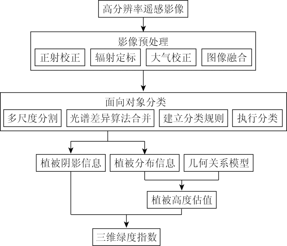
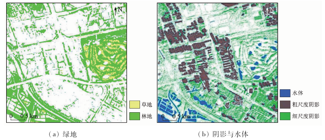
Abstract Scientific measurement is the basis for the rational planning of urban green space, and indicators of green space are vital references in the construction of urban green space for urban planners. Up till now, the greening indicators widely used in urban green space construction have all been two-dimensional, which are too rough to reflect the stereoscopic landscape of green space and its ecological benefits. Therefore, three-dimensional index (three-dimensional green index, TGI) should be constructed to evaluate the spatial landscape quality of green space construction more precisely. First, the vegetation and its shadow information are extracted through the object-oriented classification; then, the vegetation heights are retrieved according to the geometric relation model between the shadow lengths and the vegetation heights; at last, TGI is constructed and compared with the traditional index green coverage rate for analysis. A case study of Shatou Street in Futian District of Shenzhen City was carried out, and the result showed that, compared with green coverage rate, TGI is capable of evaluating the three-dimensional landscape of green space more objectively and meticulously and can reflect the eco-benefits realistically. So it can provide scientific basis for planning, decision-making and management in the construction of urban green space.
|
| Keywords
three-dimensional green index
green coverage rate
stereoscopic landscape
green space construction
|
|
|
|
Corresponding Authors:
Wen WANG
E-mail: wenw@ruc.edu.cn
|
|
Issue Date: 03 December 2019
|
|
|
| [1] |
伍学进, 曾菊新 . 试论宜居性城市绿地的规划与建设[J]. 长江流域资源与环境, 2011,20(1):28-32.
|
| [1] |
Wu X J, Zeng J X . Planning and construction of livable city green space[J]. Resources and Environment in the Yangtze Basin, 2011,20(1):28-32.
|
| [2] |
中华人民共和国住房和城乡建设部. CJJT85-2017城市绿地分类标准[S].北京: 中国建筑工业出版社, 2017.
|
| [2] |
Ministry of Housing and Urban-Rural Development of People’s Republic of China. Standard of Urban Green Space Classification[S]. Beijing: China Architecture & Building Press, 2017.
|
| [3] |
张云路, 关海莉, 李雄 . “生态园林城市”发展视角下的城市绿地评价指标优化探讨[J]. 中国城市林业, 2018,16(2):38-42.
|
| [3] |
Zhang Y L, Guan H L, Li X . Discussion of urban green space evaluation index optimization from the perspective of the development of “Ecological Garden City”[J]. Journal of Chinese Urban Forestry, 2018,16(2):38-42.
|
| [4] |
朱文泉, 何兴元, 陈玮 , 等. 城市森林结构的量化研究——以沈阳树木园森林群落为例[J]. 应用生态学报, 2003,14(12):2090-2094.
|
| [4] |
Zhu W Q, He X Y, Chen W , et al. Quantitative analysis of urban forest structure:A case study on Shenyang arboretum[J]. Chinese Journal of Applied Ecology, 2003,14(12):2090-2094.
|
| [5] |
周坚华 . 城市绿量测算模式及信息系统[J]. 地理学报, 2001,56(1):14-23.
|
| [5] |
Zhou J H . Theory and practice on database of three-dimensional vegetation quantity[J]. Acta Geographica Sinica, 2001,56(1):14-23.
|
| [6] |
刘常富, 何兴元, 陈玮 , 等. 沈阳城市森林三维绿量测算[J]. 北京林业大学学报, 2006,28(3):32-37.
|
| [6] |
Liu C F, He X Y, Chen W , et al. Tridimensional green biomass measures of Shenyang urban forests[J]. Journal of Beijing Forestry University, 2006,28(3):32-37.
|
| [7] |
张璋, 曹玉洁, 龙承柱 . 宜居视角下的居住小区绿化现状调查与经济评价研究——以北京为例[J].中国市场,2018(8):117-118.
|
| [7] |
Zhang Z, Cao Y J, Long C Z . Investigation and economic evaluation on the greening of residential areas from the perspective of livability:A case study of Beijing[J].China Market,2018(8):117-118.
|
| [8] |
吴晓霞, 顾祝军 . 不同时间尺度下基于绿量的草地水土保持效应研究[J]. 生态科学, 2016,35(1):85-91.
|
| [8] |
Wu X X, Gu Z J . Time scale influence on the study of water and soil conservation effects of grass based on live vegetation volume[J]. Ecological Science, 2016,35(1):85-91.
|
| [9] |
王忠君 . 福州植物园绿量与固碳释氧效益研究[J]. 中国园林, 2010,26(12):1-6.
|
| [9] |
Wang Z J . Research on vegetation quantity and carbon-fixing and oxygen-releasing effects of Fuzhou botanical garden[J]. Chinese Landscape Architecture, 2010,26(12):1-6.
|
| [10] |
熊向艳, 韩永伟, 高馨婷 , 等. 北京市城乡结合部17种常用绿化植物固碳释氧功能研究[J]. 环境工程技术学报, 2014,4(3):248-255.
doi: 10.3969/j.issn.1674-991X.2014.03.041
|
| [10] |
Xiong X Y, Han Y W, Gao X T , et al. Analysis of carbon fixation and oxygen release capabilities of 17 afforestation plants in rural-urba[J]. Journal of Environmental Engineering Technology, 2014,4(3):248-255.
|
| [11] |
罗英, 何小弟, 李晓储 , 等. 生态景观型城市绿地的滞尘效应分析[J].林业实用技术,2009(5):58-61.
|
| [11] |
Luo Y, He X D, Li X C , et al. Analysis on dust retention effect of ecological landscape type urban green space[J].Forest Science and Technology,2009(5):58-61.
|
| [12] |
周旭丹, 安佰仪, 王薇 , 等. 北方城市不同植物滞尘效应季节变化[J]. 江苏农业科学, 2016,44(8):489-493.
|
| [12] |
Zhou X D, An B Y, Wang W , et al. Seasonal variation of dust retention effects of different plants in northern cities[J]. Jiangsu Agricultural Sciences, 2016,44(8):489-493.
|
| [13] |
冯代丽, 刘艳红, 王斐 , 等. 基于三维绿量的城市绿地生态效益评价综述[J]. 中国农学通报, 2017,33(6):129-133.
|
| [13] |
Feng D L, Liu Y H, Wang F , et al. Review on ecological benefits evaluation of urban green space based on three-dimensional green quantity[J]. Chinese Agricultural Science Bulletin, 2017,33(6):129-133.
|
| [14] |
高吉喜, 宋婷, 张彪 , 等. 北京城市绿地群落结构对降温增湿功能的影响[J]. 资源科学, 2016,38(6):1028-1038.
doi: 10.18402/resci.2016.06.03
|
| [14] |
Gao J X, Song T, Zhang B , et al. The relationship between urban green space community structure and air temperature reduction and humidity increase in Beijing[J]. Resources Science, 2016,38(6):1028-1038.
|
| [15] |
陈荻, 李卫正, 孔文丽 , 等. 基于低空高分辨影像的三维绿量计算方法——以南京林业大学校园为例[J]. 中国园林, 2015,31(9):22-26.
|
| [15] |
Chen D, Li W Z, Kong W L , et al. On the Method of three-dimensional green volume calculation based on low-altitude high-definition images:A case study of the Nanjing Forestry University Campus[J]. Chinese Landscape Architecture, 2015,31(9):22-26
|
| [16] |
张浩, 王祥荣 . 城市绿地的三维生态特征及其生态功能[J].中国环境科学,2001(2):6-9.
|
| [16] |
Zhang H, Wang X R . Three-dimensional ecological characters of urban green space and its ecological function[J].China Environmental Science,2001(2):6-9.
|
| [17] |
Yu S, Yu B, Song W , et al. View-based greenery:A three-dimensional assessment of city buildings’ green visibility using Floor Green View Index[J]. Landscape & Urban Planning, 2016,152:13-26.
|
| [18] |
Work T T, Jacobs,J M, Spence J R, Volney W J .High levels of green-tree retention are required to preserve ground beetle biodiversity in boreal mixedwood forests[J]. Ecological Applications, 2010,20(3), 741-751.
|
| [19] |
申超, 常红雨, 林思平 , 等. 福州市不同类型绿地植被多样性与生态效益关联研究[J]. 山东农业大学学报(自然科学版), 2018,49(2):212-218.
|
| [19] |
Shen Chao, Chang H Y, Lin S P , et al. Study on the relationship between vegetation diversity and ecological benefit of different types of green land in Fuzhou City[J]. Journal of Shandong Agricultural University (Natural Science Edition), 2018,49(2):212-218.
|
| [20] |
王萍, 蒋文绪 . 昆明市大观河岸植被三维绿量及生态效益分析[J]. 山东林业科技, 2010,40(6):8-11,97.
|
| [20] |
Wang P, Jiang W X . Analysis on 3-dimension green quantity and ecological benefits of plants on Daguan River bank in Kunming[J]. Journal of Shandong Forestry Science and Technology, 2010,40(6):8-11,97.
|
| [21] |
周坚华, 黄顺忠 . 三维量遥感调查:一种估算城市绿化环境效益的新方法[J]. 上海建设科技, 1995,( 4):41-42.
|
| [21] |
Zhou J H, Huang S Z . Three dimensional remote sensing survey:A new method to estimate the environmental benefits of urban greenery[J]. Shanghai Construction Science & Technology, 1995,( 4):41-42.
|
| [22] |
Christoph B P, Daniel N M D, Nicholas J C X .Logit modeling to map canopy closure in conifer plantations:a case study using landsat TM data from SW Scotland[M] //The Remote Sensing Society.Remote Sensing Society Observations & Internations.New York:The Remote Sensing Society, 1997: 171-176.
|
| [23] |
周坚华, 孙天纵 . 三维绿色生物量的遥感模式研究与绿化环境效益估算[J]. 环境遥感, 1995,10(3):162-174.
|
| [23] |
Zhou J H, Sun T Z . Study on remote sensing model of three-dimensional green biomass and the estimation of environmental benefits of greenery[J]. Journal of Remote Sensing, 1995,10(3):162-174.
|
| [24] |
张良培, 郑兰芬, 童庆禧 , 等. 利用高光谱对生物变量进行估计[J]. 遥感学报, 1997,1(2):111-114.
doi: 10.11834/jrs.19970206
|
| [24] |
Zhang L P, Zheng L F, Tong Q X , et al. The estimation of vegetation variables based on high resolution spectra[J]. Journal of Remote Sensing, 1997,1(2):111-114.
|
| [25] |
Li Y, Demetriades-Shah T H, Kanemasu E T ,et al.Use of second derivatives of canopy reflectance for monitoring prairie vegetation over different soil backgrounds[J]. Remote Sensing of Environment, 1993,44(1):81-87.
|
| [26] |
胡毅华, 杨旭龙, 刘媛萍 . 太阳影子定位模型的构建[J]. 洛阳师范学院学报, 2015,34(11):13-18.
|
| [26] |
Hu Y H, Yang X L, Liu Y P . Construction of the model of sun shadow position[J]. Journal of Luoyang Normal University, 2015,34(11):13-18.
|
| [27] |
肖昶, 余晓敏, 韩逸飞 . 高分二号卫星影像融合技术研究[J]. 地理空间信息, 2018,16(6):13-16,7.
|
| [27] |
Xiao C, Yu X M, Han Y F . Research on image fusion technology of GF-2 satellite[J]. Geospatial Information, 2018,16(6):13-16,7.
|
| [28] |
Tansey K, Chambers I, Anstee A , et al. Object-oriented classification of very high resolution airborne imagery for the extraction of hedgerows and field margin cover in agricultural areas[J]. Applied Geography, 2009,29(2):145-157.
|
| [29] |
Blaschke T . Object basedimage analysis for remote sensing[J]. ISPRS journal of photogrammetry and remote sensing, 2010,65(1), 2-16.
|
| [30] |
帅慕蓉, 谢贻文, 杨鹏飞 . 基于eCognition高分辨率影像的分类研究[J]. 无线互联科技, 2018,15(11):98-99.
|
| [30] |
Shuai M R, Xie Y W, Yang P F . Research on the classification of high-resolution remote sensing images based on eCognition[J]. Wireless Internet Technology, 2018,15(11):98-99.
|
| [31] |
田峰, 陈冬花, 黄新利 , 等. 基于形态学阴影指数的高分二号影像建筑物高度估计[J]. 遥感技术与应用, 2017,32(5):844-850.
|
| [31] |
Tian F, Chen D H, Huang X L , et al. Building height estimation from GF-2 image based on morphological shadow index[J]. Remote Sensing Technology and Application, 2017,32(5):844-850.
|
| [32] |
Lee T, Kim T . Automatic building height extraction by volumetric shadow analysis of monoscopic imagery[J]. International Journal of Remote Sensing, 2013,34(16):5834-5850.
|
| [33] |
毛学刚, 杜子涵, 刘家倩 , 等. 基于面向对象的Quick-Bird遥感影像林隙分割与分类[J]. 应用生态学报, 2018,29(1):44-52.
|
| [33] |
Mao X G, Du Z H, Liu J Q , et al. Object-oriented segmentation and classification of forest gap based on Quick Bird remote sensing image[J]. Chinese Journal of Applied Ecology, 2018,29(1):44-52.
|
|
Viewed |
|
|
|
Full text
|
|
|
|
|
Abstract
|
|
|
|
|
Cited |
|
|
|
|
| |
Shared |
|
|
|
|
| |
Discussed |
|
|
|
|
 2019,
Vol. 31
2019,
Vol. 31