|
|
|
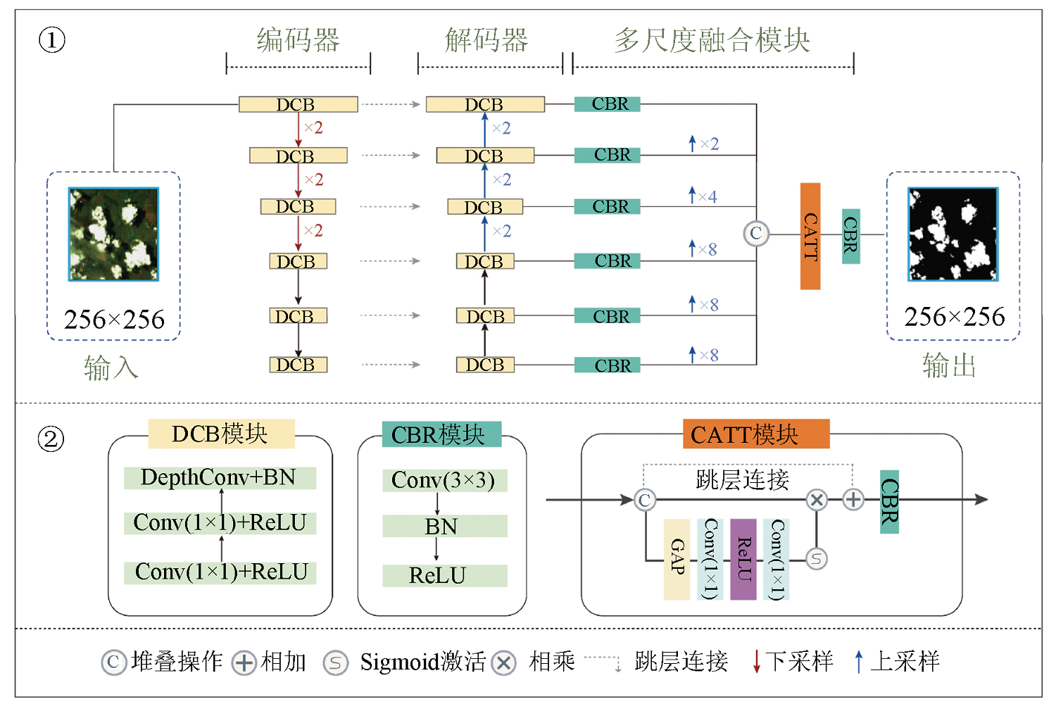
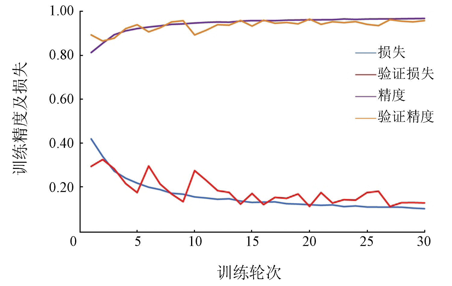
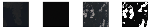
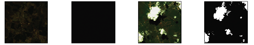
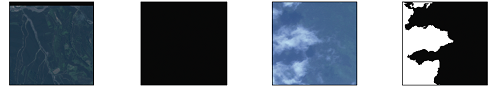
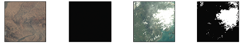
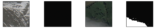
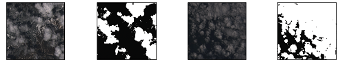
Abstract Cloud detection, as a crucial step in preprocessing optical satellite images, plays a significant role in the subsequent application analysis. The increasingly enriched optical satellite remote sensing images pose a challenge in achieving quick cloud detection of numerous multi-source satellite remote sensing images. Given that conventional cloud detection exhibits low accuracy and limited universality, this study proposed a multi-scale feature fusion neural network model, i.e., the multi-source remote sensing cloud detection network (MCDNet). The MCDNet comprises a U-shaped architecture and a lightweight backbone network, and its decoder integrates multi-scale feature fusion and a channel attention mechanism to enhance model performance. The MCDNet model was trained using tens of thousands of globally distributed multi-source satellite images, covering commonly used satellite data like Google and Landsat data and domestic satellite data like GF-1, GF-2, and GF-5 data. Several classic semantic segmentation models were used for comparison with the MCDNet model in the experiment. The experimental results indicate that the MCDNet model exhibited superior performance in cloud detection, achieving detection accuracy of over 90% for all types of satellite data. Additionally, the MCDNet model was tested on the Sentinel data that were not used in training, yielding satisfactory cloud detection effects. This demonstrates the MCDNet model’s robustness and potential for use as a general model for cloud detection of medium- to high-resolution satellite images.
|
| Keywords
cloud detection
deep learning
multi-source remote sensing
domestic satellite
convolutional neural network
attention mechanism
|
|
|
|
Issue Date: 21 December 2023
|
|
|
| [1] |
King M D, Platnick S, Menzel W P, et al. Spatial and temporal distribution of clouds observed by MODIS onboard the Terra and Aqua satellites[J]. IEEE Transactions on Geoscience and Remote Sensing, 2013, 51(7):3826-3852.
doi: 10.1109/TGRS.2012.2227333
url: http://ieeexplore.ieee.org/document/6422379/
|
| [2] |
Yu J, Yan B. Efficient solution of large-scale domestic hyperspectral data processing and geological application[C]// 2017 International Workshop on Remote Sensing with Intelligent Processing (RSIP).IEEE, 2017:1-4.
|
| [3] |
Irish R R, Barker J L, Goward S N, et al. Characterization of the Landsat7 ETM+ automated cloud-cover assessment (ACCA) algorithm[J]. Photogrammetric Engineering and Remote Sensing, 2006, 72(10):1179-1188.
doi: 10.14358/PERS.72.10.1179
url: http://openurl.ingenta.com/content/xref?genre=article&issn=0099-1112&volume=72&issue=10&spage=1179
|
| [4] |
Zhu Z, Woodcock C E. Object-based cloud and cloud shadow detection in Landsat imagery[J]. Remote Sensing of Environment, 2012, 118:83-94.
doi: 10.1016/j.rse.2011.10.028
url: https://linkinghub.elsevier.com/retrieve/pii/S0034425711003853
|
| [5] |
Zhu Z, Wang S, Woodcock C E. Improvement and expansion of the Fmask algorithm:Cloud,cloud shadow,and snow detection for Landsats4-7,8,and Sentinel-2 images[J]. Remote Sensing of Environment, 2015, 159:269-277.
doi: 10.1016/j.rse.2014.12.014
url: https://linkinghub.elsevier.com/retrieve/pii/S0034425714005069
|
| [6] |
Rossow W B, Garder L C. Cloud detection using satellite measurements of infrared and visible radiances for ISCCP[J]. Journal of Climate, 1993, 6(12):2341-2369.
doi: 10.1175/1520-0442(1993)006<2341:CDUSMO>2.0.CO;2
url: http://journals.ametsoc.org/doi/10.1175/1520-0442(1993)006<2341:CDUSMO>2.0.CO;2
|
| [7] |
Gesell G. An algorithm for snow and ice detection using AVHRR data:An extension to the APOLLO software package[J]. International Journal of Remote Sensing, 1989, 10(4/5):897-905.
doi: 10.1080/01431168908903929
url: https://www.tandfonline.com/doi/full/10.1080/01431168908903929
|
| [8] |
Stowe L L, McClain E P, Carey R, et al. Global distribution of cloud cover derived from NOAA/AVHRR operational satellite data[J]. Advances in Space Research, 1991, 11(3):51-54.
|
| [9] |
Qiu S, He B, Zhu Z, et al. Improving Fmask cloud and cloud shadow detection in mountainous area for Landsats4-8 images[J]. Remote Sensing of Environment, 2017, 199:107-119.
doi: 10.1016/j.rse.2017.07.002
url: https://linkinghub.elsevier.com/retrieve/pii/S0034425717303073
|
| [10] |
Qiu S, Zhu Z, He B. Fmask 4.0:Improved cloud and cloud shadow detection in Landsats4-8 and Sentinel-2 imagery[J]. Remote Sensing of Environment, 2019, 231:111205.
doi: 10.1016/j.rse.2019.05.024
url: https://linkinghub.elsevier.com/retrieve/pii/S0034425719302172
|
| [11] |
Zhu X, Helmer E H. An automatic method for screening clouds and cloud shadows in optical satellite time series in cloudy regions[J]. Remote Sensing of Environment, 2018, 214:135-153.
doi: 10.1016/j.rse.2018.05.024
url: https://linkinghub.elsevier.com/retrieve/pii/S0034425718302530
|
| [12] |
Frantz D, Haß E, Uhl A, et al. Improvement of the Fmask algorithm for Sentinel-2 images:Separating clouds from bright surfaces based on parallax effects[J]. Remote Sensing of Environment, 2018, 215:471-481.
doi: 10.1016/j.rse.2018.04.046
url: https://linkinghub.elsevier.com/retrieve/pii/S0034425718302037
|
| [13] |
Bian J, Li A, Liu Q, et al. Cloud and snow discrimination for CCD images of HJ-1A/B constellation based on spectral signature and spatio-temporal context[J]. Remote Sensing, 2016, 8(1):31.
doi: 10.3390/rs8010031
url: http://www.mdpi.com/2072-4292/8/1/31
|
| [14] |
葛曙乐, 董胜越, 孙根云, 等. 一种适用于高分五号全谱段光谱成像仪影像的云检测算法[J]. 上海航天, 2019, 36(s2):204-209.
|
| [14] |
Ge S L, Dong S Y, Sun G Y, et al. Cloud detection algorithm for images of visual and infrared multispectral imager[J]. Aerospace Shanghai, 2019, 36(s2):204-209.
|
| [15] |
Zhan Y, Wang J, Shi J, et al. Distinguishing cloud and snow in satellite images via deep convolutional network[J]. IEEE Geoscience and Remote Sensing Letters, 2017, 14(10):1785-1789.
doi: 10.1109/LGRS.2017.2735801
url: http://ieeexplore.ieee.org/document/8013916/
|
| [16] |
Wang L, Chen Y, Tang L, et al. Object-based convolutional neural networks for cloud and snow detection in high-resolution multispectral imagers[J]. Water, 2018, 10(11):1666.
doi: 10.3390/w10111666
url: http://www.mdpi.com/2073-4441/10/11/1666
|
| [17] |
Oishi Y, Ishida H, Nakamura R. A new Landsat8 cloud discrimination algorithm using thresholding tests[J]. International Journal of Remote Sensing, 2018, 39(23):9113-9133.
doi: 10.1080/01431161.2018.1506183
url: https://www.tandfonline.com/doi/full/10.1080/01431161.2018.1506183
|
| [18] |
Shao Z, Pan Y, Diao C, et al. Cloud detection in remote sensing images based on multiscale features-convolutional neural network[J]. IEEE Transactions on Geoscience and Remote Sensing, 2019, 57(6):4062-4076.
doi: 10.1109/TGRS.36
url: https://ieeexplore.ieee.org/xpl/RecentIssue.jsp?punumber=36
|
| [19] |
Hong Y, Hsu K L, Sorooshian S, et al. Precipitation estimation from remotely sensed imagery using an artificial neural network cloud classification system[J]. Journal of Applied Meteorology, 2004, 43(12):1834-1853.
doi: 10.1175/JAM2173.1
url: https://journals.ametsoc.org/doi/10.1175/JAM2173.1
|
| [20] |
Hall D K, Riggs G A, Salomonson V V. Development of methods for mapping global snow cover using moderate resolution imaging spectroradiometer data[J]. Remote Sensing of Environment, 1995, 54(2):127-140.
doi: 10.1016/0034-4257(95)00137-P
url: https://linkinghub.elsevier.com/retrieve/pii/003442579500137P
|
| [21] |
Ghasemian N, Akhoondzadeh M. Introducing two random forest based methods for cloud detection in remote sensing images[J]. Advances in Space Research, 2018, 62(2):288-303.
doi: 10.1016/j.asr.2018.04.030
url: https://linkinghub.elsevier.com/retrieve/pii/S0273117718303624
|
| [22] |
Egli S, Thies B, Bendix J. A hybrid approach for fog retrieval based on a combination of satellite and ground truth data[J]. Remote Sensing, 2018, 10(4):628.
doi: 10.3390/rs10040628
url: https://www.mdpi.com/2072-4292/10/4/628
|
| [23] |
Lee Y, Wahba G, Ackerman S A. Cloud classification of satellite radiance data by multicategory support vector machines[J]. Journal of Atmospheric and Oceanic Technology, 2004, 21(2):159-169.
doi: 10.1175/1520-0426(2004)021<0159:CCOSRD>2.0.CO;2
url: http://journals.ametsoc.org/doi/10.1175/1520-0426(2004)021<0159:CCOSRD>2.0.CO;2
|
| [24] |
Ishida H, Oishi Y, Morita K, et al. Development of a support vector machine based cloud detection method for MODIS with the adjustability to various conditions[J]. Remote Sensing of Environment, 2018, 205:390-407.
doi: 10.1016/j.rse.2017.11.003
url: https://linkinghub.elsevier.com/retrieve/pii/S0034425717305138
|
| [25] |
Li Z, Shen H, Cheng Q, et al. Deep learning based cloud detection for medium and high resolution remote sensing images of different sensors[J]. ISPRS Journal of Photogrammetry and Remote Sensing, 2019, 150:197-212.
doi: 10.1016/j.isprsjprs.2019.02.017
url: https://linkinghub.elsevier.com/retrieve/pii/S0924271619300565
|
| [26] |
Ma L, Liu Y, Zhang X, et al. Deep learning in remote sensing applications:A meta-analysis and review[J]. ISPRS Journal of Photogrammetry and Remote Sensing, 2019, 152:166-177.
doi: 10.1016/j.isprsjprs.2019.04.015
url: https://linkinghub.elsevier.com/retrieve/pii/S0924271619301108
|
| [27] |
Yu J, Zhang L, Li Q, et al. 3D autoencoder algorithm for lithological mapping using ZY-1 02D hyperspectral imagery:A case study of Liuyuan region[J]. Journal of Applied Remote Sensing, 2021, 15(4):042610.
|
| [28] |
Tsagkatakis G, Aidini A, Fotiadou K, et al. Survey of deep-learning approaches for remote sensing observation enhancement[J]. Sensors, 2019, 19(18):3929.
doi: 10.3390/s19183929
url: https://www.mdpi.com/1424-8220/19/18/3929
|
| [29] |
Yang J, Guo J, Yue H, et al. CDnet:CNN-based cloud detection for remote sensing imagery[J]. IEEE Transactions on Geoscience and Remote Sensing, 2019, 57(8):6195-6211.
doi: 10.1109/TGRS.36
url: https://ieeexplore.ieee.org/xpl/RecentIssue.jsp?punumber=36
|
| [30] |
Jeppesen J H, Jacobsen R H, Inceoglu F, et al. A cloud detection algorithm for satellite imagery based on deep learning[J]. Remote Sensing of Environment, 2019, 229:247-259.
doi: 10.1016/j.rse.2019.03.039
|
| [31] |
Drönner J, Korfhage N, Egli S, et al. Fast cloud segmentation using convolutional neural networks[J]. Remote Sensing, 2018, 10(11):1782.
doi: 10.3390/rs10111782
url: http://www.mdpi.com/2072-4292/10/11/1782
|
| [32] |
刘广进, 王光辉, 毕卫华, 等. 基于DenseNet与注意力机制的遥感影像云检测算法[J]. 自然资源遥感, 2022, 34(2):88-96.doi:10.6046/zrzyyg.2021128.
|
| [32] |
Liu G J, Wang G H, Bi W H, et al. Cloud detection algorithm of remote sensing image based on DenseNet and attention mechanism[J]. Remote Sensing for Natural Resources, 2022, 34(2):88-96.doi:10.6046/zrzyyg.2021128.
|
| [33] |
Chai D, Newsam S, Zhang H K, et al. Cloud and cloud shadow detection in Landsat imagery based on deep convolutional neural networks[J]. Remote Sensing of Environment, 2019, 225:307-316.
doi: 10.1016/j.rse.2019.03.007
url: https://linkinghub.elsevier.com/retrieve/pii/S0034425719300987
|
| [34] |
Mohajerani S, Saeedi P. Cloud-net+:A cloud segmentation CNN for Landsat8 remote sensing imagery optimized with filtered jaccard loss function[J/OL]. arXiv, 2020(2020-01-23)[2021-04-23]. https://arxiv.org/abs/2001.08768v1.
url: https://arxiv.org/abs/2001.08768v1
|
| [35] |
Guo Z S, Li C H, Wang Z M, et al. A cloud boundary detection scheme combined with ASLIC and CNN using ZY-3,GF-1/2 satellite imagery[J]. International Archives of the Photogrammetry,Remote Sensing and Spatial Information Sciences, 2018, 42(3):455-458.
|
| [36] |
Zi Y, Xie F, Jiang Z. A cloud detection method for Landsat8 images based on PCANet[J]. Remote Sensing, 2018, 10(6):877.
doi: 10.3390/rs10060877
url: http://www.mdpi.com/2072-4292/10/6/877
|
| [37] |
Yu J C, Li Y, Zheng X, et al. An effective cloud detection method for Gaofen-5 images via deep learning[J]. Remote Sensing, 2020, 12(13):2106.
doi: 10.3390/rs12132106
url: https://www.mdpi.com/2072-4292/12/13/2106
|
| [38] |
仇一帆, 柴登峰. 无人工标注数据的Landsat影像云检测深度学习方法[J]. 国土资源遥感, 2021, 33(1): 102-107.doi:10.6046/gtzyyg.2020090.
|
| [38] |
Qiu Y F, Chai D F. A deep learning method for Landsat image cloud detection without manually labeled data[J]. Remote Sensing for Land and Resources, 2021, 33(1): 102-107.doi:10.6046/gtzyyg.2020090.
|
| [39] |
Ronneberger O, Fischer P, Brox T. U-net:Convolutional networks for biomedical image segmentation[C]//International Conference on Medical Image Computing and Computer-Assisted Intervention. Cham:Springer, 2015:234-241.
|
| [40] |
Mohajerani S, Saeedi P. Cloud-Net:An end-to-end cloud detection algorithm for Landsat8 imagery[C]// 2019 IEEE International Geoscience and Remote Sensing Symposium.IEEE, 2019: 1029-1032.
|
| [41] |
Wu X, Shi Z, Zou Z. A geographic information-driven method and a new large scale dataset for remote sensing cloud/snow detection[J]. ISPRS Journal of Photogrammetry and Remote Sensing, 2021, 174:87-104.
doi: 10.1016/j.isprsjprs.2021.01.023
url: https://linkinghub.elsevier.com/retrieve/pii/S0924271621000290
|
| [42] |
He Q, Sun X, Yan Z, et al. DABNet:Deformable contextual and boundary-weighted network for cloud detection in remote sensing images[J]. IEEE Transactions on Geoscience and Remote Sensing, 2021, 60:5601216.
|
| [43] |
Badrinarayanan V, Kendall A, Cipolla R. SegNet:A deep convolutional encoder-decoder architecture for image segmentation[J]. IEEE Transactions on Pattern Analysis and Machine Intelligence, 2015, 39:2481-2495.
doi: 10.1109/TPAMI.34
url: https://ieeexplore.ieee.org/xpl/RecentIssue.jsp?punumber=34
|
| [44] |
Zhao H, Shi J, Qi X, et al. Pyramid scene parsing network[C]// 2017 IEEE Conference on Computer Vision and Pattern Recognition, 2017:6230-6239.
|
| [45] |
Yu C, Wang J, Peng C, et al. Bisenet:Bilateral segmentation network for real-time semantic segmentation[C]// 15th European Conference on Computer Vision (ECCV), 2018:334-349.
|
| [46] |
Sun K, Zhao Y, Jiang B, et al. High-resolution representations for labeling pixels and regions[J/OL]. arXiv, 2019(2019-04-09)[2021-04-23]. https://arxiv.org/abs/1904.04514.pdf.
url: https://arxiv.org/abs/1904.04514.pdf
|
| [47] |
Chen L C, Zhu Y, Papandreou G, et al. Encoder-decoder with atrous separable convolution for semantic image segmentation[C]// 15th European Conference on Computer Vision (ECCV), 2018:833-851.
|
|
Viewed |
|
|
|
Full text
|
|
|
|
|
Abstract
|
|
|
|
|
Cited |
|
|
|
|
| |
Shared |
|
|
|
|
| |
Discussed |
|
|
|
|
 2023,
Vol. 35
2023,
Vol. 35
 )
)