|
|
|
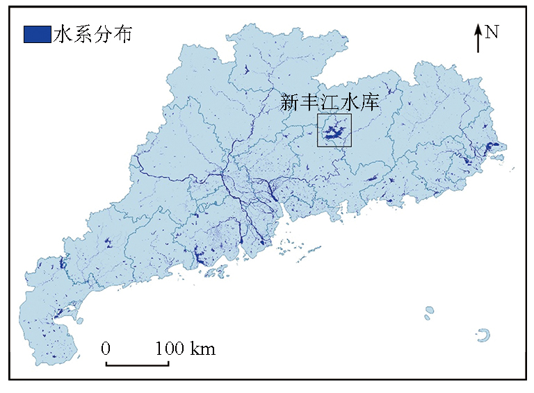
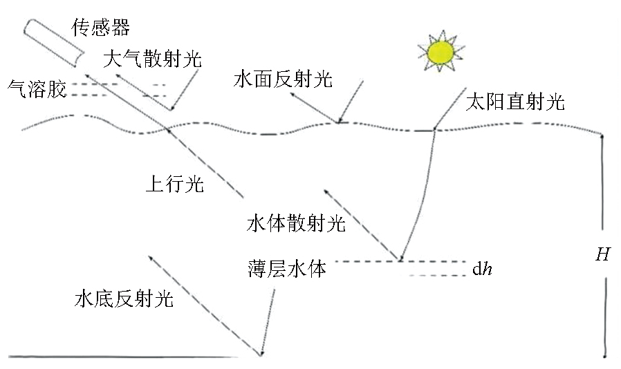
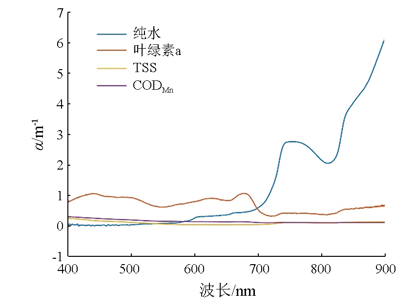
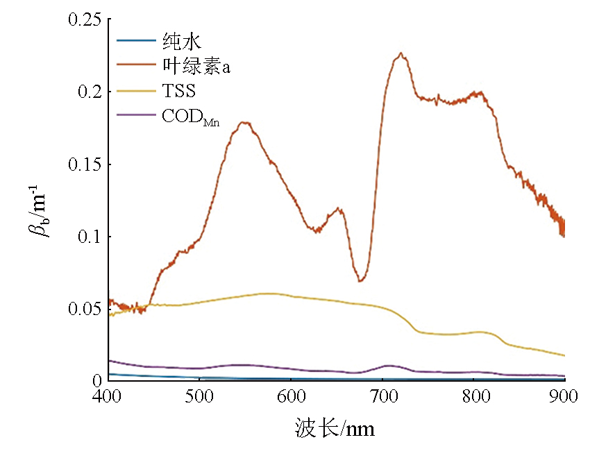
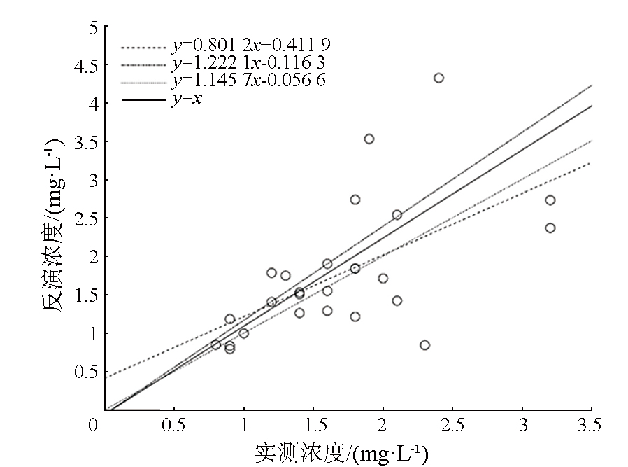
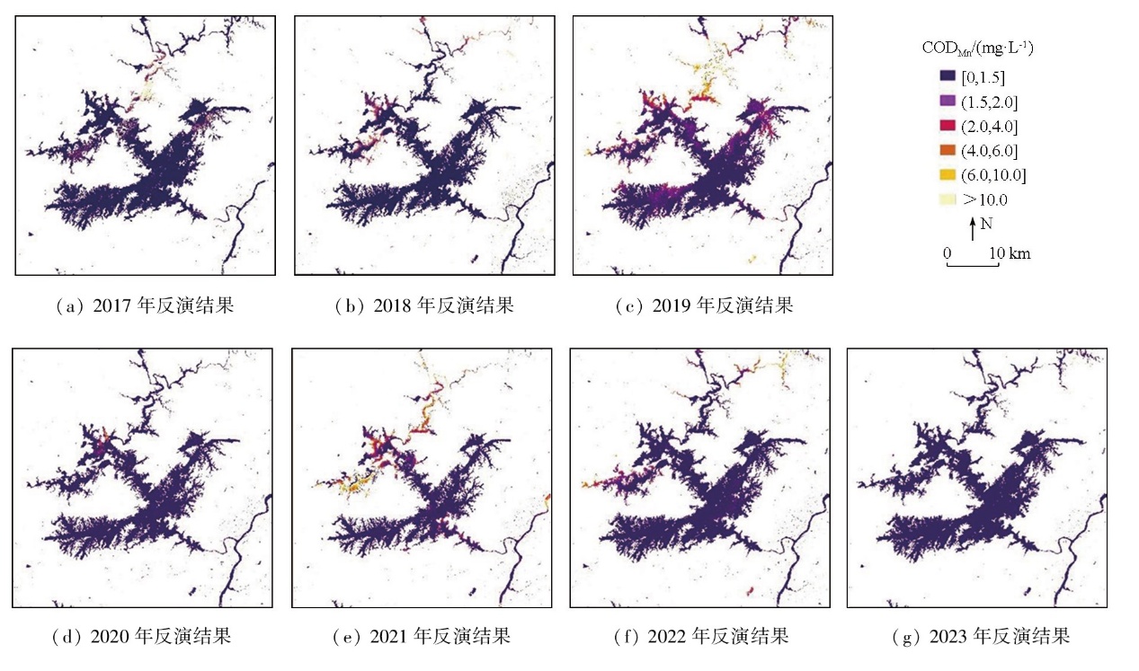
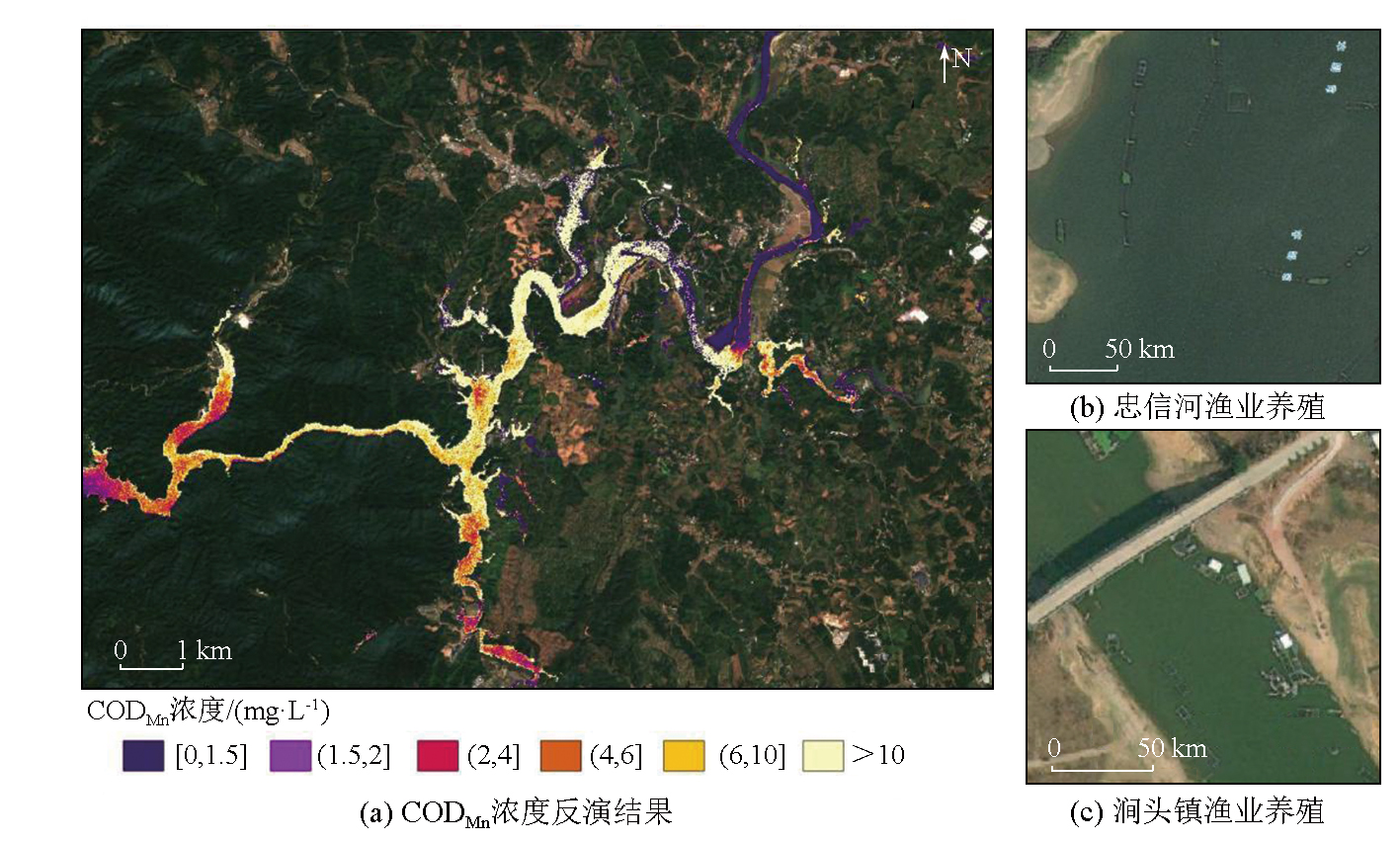
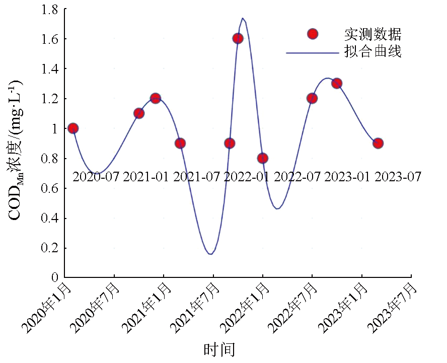
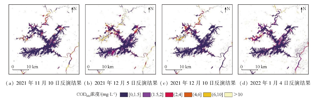
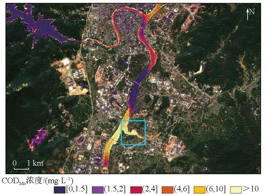
Abstract To protect the water quality of the Xinfengjiang Reservoir and monitor the eutrophication risk,this study developed an analytical model for remote sensing inversion of chemical oxygen demand (CODMn) based on the underwater radiative transfer process. This model comprehensively takes into account three water quality parameters that influence the underwater light field:chlorophyll a,total suspended matter,and CODMn. The model was applied to conduct multi-temporal monitoring of eutrophication in the reservoir and its surrounding rivers. Through accuracy verification,the model achieved a root mean square error of 0.68 and a mean absolute percentage error of 25.22%,demonstrating its reliability in complex water environments. The spatiotemporal analysis of the water quality in Xinfengjiang Reservoir revealed the consistent good quality of the main body over the long term. However,due to extensive aquaculture and anthropogenic discharges,the Zhongxin River exhibited frequent eutrophication,which may pose a potential threat to the overall water quality of the reservoir. It is recommended to enhance monitoring of the Zhongxin River,promptly address illegal discharges,and implement ecological engineering measures such as vegetative drainage ditches in the watershed. These efforts can effectively reduce agricultural non-point source pollution,contributing to the restoration and improvement of the ecological environment of Xinfengjiang Reservoir.
|
| Keywords
water quality inversion
Xinfengjiang Reservoir
chemical oxygen demand (CODMn)
organic pollution
|
|
|
|
Issue Date: 28 October 2025
|
|
|
| [1] |
Xie W Q, Gong Y X. Measurement of permanganate index in environmental water via indirect phase-conversion strategy[J]. Journal of Chromatography A, 2024, 1728:464987.
|
| [2] |
Li J, Luo G B, He L J, et al. Analytical approaches for determining chemical oxygen demand in water bodies:A review[J]. Critical Reviews in Analytical Chemistry, 2018, 48(1):47-65.
|
| [3] |
Guan Q, Feng L, Hou X J, et al. Eutrophication changes in fifty large lakes on the Yangtze Plain of China derived from MERIS and OLCI observations[J]. Remote Sensing of Environment, 2020, 246:111890.
|
| [4] |
Ambrose-Igho G, Seyoum W M, Perry W L, et al. Spatiotemporal analysis of water quality indicators in small lakes using sentinel-2 satellite data:Lake Bloomington and evergreen lake,central Illinois,USA[J]. Environmental Processes, 2021, 8(2):637-660.
|
| [5] |
Yang H B, Kong J L, Hu H H, et al. A review of remote sensing for water quality retrieval:Progress and challenges[J]. Remote Sen-sing, 2022, 14(8):1770.
|
| [6] |
Lee Z P, Carder K L, Hawes S K, et al. Model for the interpretation of hyperspectral remote-sensing reflectance[J]. Applied Optics, 1994, 33(24):5721-5732.
doi: 10.1364/AO.33.005721
pmid: 20935974
|
| [7] |
Neil C, Spyrakos E, Hunter P D, et al. A global approach for chlorophyll-a retrieval across optically complex inland waters based on optical water types[J]. Remote Sensing of Environment, 2019, 229:159-178.
doi: 10.1016/j.rse.2019.04.027
|
| [8] |
Guo Q, Zhang D J, Cao L J, et al. A remote sensing method to inverse chemical oxygen demand in Qinghai Lake[C]// 2021 IEEE International Geoscience and Remote Sensing Symposium IGARSS. IEEE, 2021:3697-3700.
|
| [9] |
Yang B, Liu Y P, Ou F P, et al. Temporal and spatial analysis of COD concentration in east Dongting Lake by using of remotely sensed data[J]. Procedia Environmental Sciences, 2011, 10:2703-2708.
|
| [10] |
Sharaf E D E, Zhang Y, Suliman A. Mapping concentrations of surface water quality parameters using a novel remote sensing and artificial intelligence framework[J]. International Journal of Remote Sensing, 2017, 38(4):1023-1042.
|
| [11] |
Cai X L, Li Y M, Lei S H, et al. A hybrid remote sensing approach for estimating chemical oxygen demand concentration in optically complex waters:A case study in inland lake waters in Eastern China[J]. Science of The Total Environment, 2023, 856:158869.
|
| [12] |
陈瑞, 周雯, 乔永民, 等. 新丰江水库沉积物磷赋存形态及分布特征[J]. 水生态学杂志, 2025, 46(1):133-142.
|
| [12] |
Chen R, Zhou W, Qiao Y M, et al. Phosphorus speciation and distribution in the sediments of Xinfeng River Reservoir[J]. Journal of Hydroecology, 2025, 46(1):133-142.
|
| [13] |
胡传鹤. 广东省新丰江水库集水区小流域农田化肥氮磷流失及环境归趋研究[D]. 西安: 陕西科技大学, 2023.
|
| [13] |
Hu C H. Study on the loss of fertilizer,nitrogen and phosphorus from farmland in a small watershed in the catchment area of Xinfengjiang reservoir,Guangdong province and its environmental fate[D]. Xi’an: Shaanxi University of Science and Technology, 2023.
|
| [14] |
Ansper A, Alikas K. Retrieval of chlorophyll a from Sentinel-2 MSI data for the European union water framework directive reporting purposes[J]. Remote Sensing, 2019, 11(1):64.
|
| [15] |
Stavn R H. Light attenuation in natural waters:Gershun’s law,lambert-beer law,and the mean light path[J]. Applied Optics, 1981, 20(14):2326_1-2327.
|
| [16] |
Lee Z P, Carder K L, Mobley C D, et al. Hyperspectral remote sensing for shallow waters.I.A semianalytical model[J]. Applied Optics, 1998, 37(27):6329-6338.
pmid: 18286131
|
| [17] |
邓孺孺, 何颖清, 秦雁, 等. 分离悬浮质影响的光学波段(400—900nm)水吸收系数测量[J]. 遥感学报, 2012, 16(1):174-191.
|
| [17] |
Deng R R, He Y Q, Qin Y, et al. Pure water absorption coefficient measurement after eliminating the impact of suspended substance in spectrum from 400 nm to 900 nm[J]. Journal of Remote Sen-sing, 2012, 16(1):174-191.
|
| [18] |
邓孺孺, 何颖清, 秦雁, 等. 近红外波段(900—2500nm)水吸收系数测量[J]. 遥感学报, 2012, 16(1):192-206.
|
| [18] |
Deng R R, He Y Q, Qin Y, et al. Measuring pure water absorption coefficient in the near-infrared spectrum(900—2500 nm)[J]. Journal of Remote Sensing, 2012, 16(1):192-206.
|
| [19] |
何颖清, 邓孺孺, 陈启东, 等. 基于ASD光谱仪的悬浮泥沙光学衰减系数研究[J]. 中山大学学报(自然科学版), 2011, 50(3):134-140.
|
| [19] |
He Y Q, Deng R R, Chen Q D, et al. Diffuse attenuation coefficient of suspended sediment based on ASD spectrometer[J]. Acta Scientiarum Naturalium Universitatis Sunyatseni, 2011, 50(3):134-140.
|
| [20] |
Wang M H. Atmospheric correction for remotely-sensed ocean-co-lour products[M]// Dartmouth,Canada:IOCCG,2010:5-6
|
| [21] |
刘小平, 邓孺孺, 彭晓鹃. 基于TM影像的快速大气校正方法[J]. 地理科学, 2005,(1):87-93.
|
| [21] |
Liu X P, Deng R R, Peng X J. A fast atmospheric correction met-hod based on TM imagery[J]. Scientia Geographica Sinica, 2005,(1):87-93.
|
| [22] |
齐志新, 邓孺孺. 多暗像元大气校正方法[J]. 国土资源遥感, 2007, 19(2):16-19,30,98.doi:10.6046/gtzyyg.2007.02.04.
|
| [22] |
Qi Z X, Deng R R. The atmospheric correction method for nonhomogeneous atmosphere based on many dark objects[J]. Remote Sensing for Land and Resources, 2007, 19(2):16-19,30,98.doi:10.6046/gtzyyg.2007.02.04.
|
|
Viewed |
|
|
|
Full text
|
|
|
|
|
Abstract
|
|
|
|
|
Cited |
|
|
|
|
| |
Shared |
|
|
|
|
| |
Discussed |
|
|
|
|
 2025,
Vol. 37
2025,
Vol. 37
 ), DENG Ruru1,2,3,4(