|
|
 |
|

|
|
|
Intelligent detection of crab ponds using remote sensing images based on a cooperative interpretation mechanism |
JIANG Zhuoran1( ), ZHOU Xinxin2,3,4, CAO Wei5, WANG Yahua1,3,4, WU Changbin1,3,4() ), ZHOU Xinxin2,3,4, CAO Wei5, WANG Yahua1,3,4, WU Changbin1,3,4() |
1. School of Geography, Nanjing Normal University, Nanjing 210023, China
2. School of Geographic and Biologic Information, Nanjing University of Posts and Telecommunications, Nanjing 210023, China
3. Key Lab of Virtual Geographic Environment, Ministry of Education, Nanjing Normal University, Nanjing 210023, China
4. Jiangsu Center for Collaborative Innovation in Geographical Information Resource Development and Application, Nanjing 210023,China
5. Nanjing Guotu Information Industry Co., Ltd., Nanjing 210000, China |
|
|
|
|
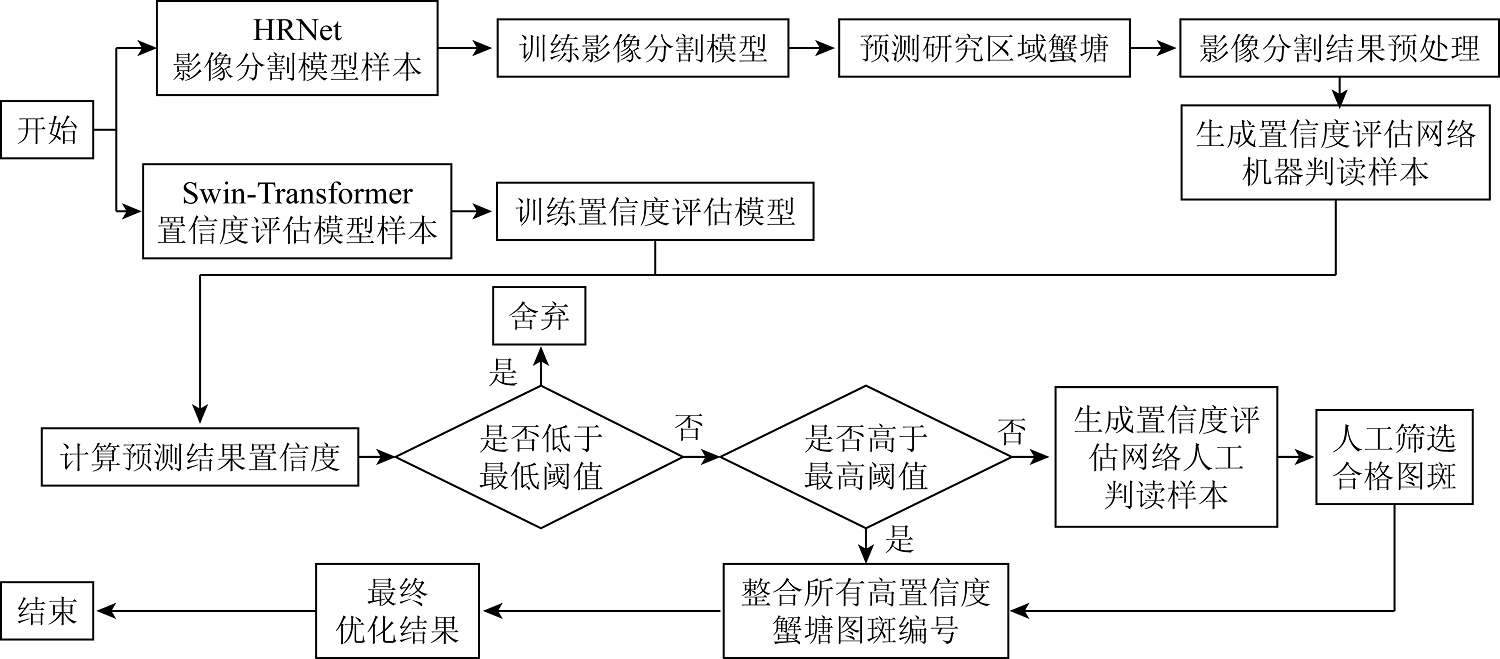
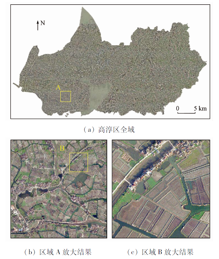
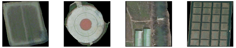
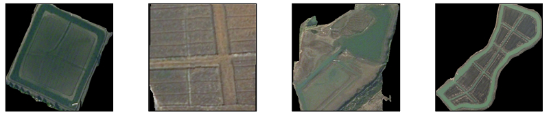
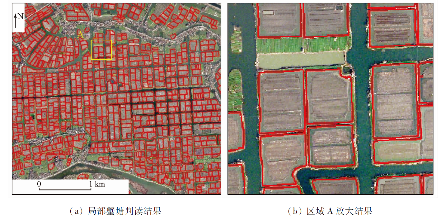
Abstract Digging ponds to raise crabs is a non-grain behavior of cultivated land, endangering national food security. However, the intelligent interpretation of remote sensing images targeting this behavior faces challenges such as laborious manual interpretation and low verification efficiency. Based on a cooperative interpretation mechanism, this study proposed an intelligent method for detecting crab ponds using remote sensing images. This method, integrating the HRNet segmentation network and the Swin-Transformer classification network models and combining manual verification, improved the detection accuracy and work efficiency. The application results of this method to Gaochun District, Nanjing City, Jiangsu Province show that the method for intelligent detection can automatically determine 83.4% of the spots for detection, with final identification accuracy of 0.972. The method proposed in this study can significantly reduce the identification difficulty and manual verification workload while improving the detection accuracy. Therefore, this study will provide a reliable solution for the accurate and efficient detection of non-grain surface features such as crab ponds.
|
| Keywords
cooperative interpretation mechanism
HRNet
Swin-Transformer
crab pond detection
non-grain
|
|
|
|
Issue Date: 19 September 2023
|
|
|
| [1] |
杨瑞珍, 陈印军, 易小燕, 等. 耕地流转中过度“非粮化”倾向产生的原因与对策[J]. 中国农业资源与区划, 2012, 33(3):14-17.
|
| [1] |
Yang R Z, Chen Y J, Yi X Y, et al. The causes and countermeasures on the excessive “non-food” tendency in the process of land transfer[J]. Chinese Journal of Agricultural Resources and Regional Planning, 2012, 33(3):14-17.
|
| [2] |
王勇, 陈印军, 易小燕, 等. 耕地流转中的“非粮化”问题与对策建议[J]. 中国农业资源与区划, 2011, 32(4):13-16.
|
| [2] |
Wang Y, Chen Y J, Yi X Y, et al. The non-grain problem in the process of land transfer and the countermeasures[J]. Chinese Journal of Agricultural Resources and Regional Planning, 2011, 32(4):13-16.
|
| [3] |
匡远配, 刘洋. 农地流转过程中的“非农化”、“非粮化”辨析[J]. 农村经济, 2018(4):1-6.
|
| [3] |
Kuang Y P, Liu Y. Distingushing “non-agriculturalization” and “non-grainification” in the process of rural land transfer[J]. Rural Economy, 2018(4):1-6.
|
| [4] |
李小江, 孟庆岩, 王春梅, 等. 一种面向对象的像元级遥感图像分类方法[J]. 地球信息科学学报, 2013, 15(5):744-751.
|
| [4] |
Li X J, Meng Q Y, Wang C M, et al. A hybrid model of object-oriented and pixel based classification of remotely sensed data[J]. Journal of Geo-Information Science, 2013, 15(5):744-751.
doi: 10.3724/SP.J.1047.2013.00744
url: http://www.dqxxkx.cn/CN/10.3724/SP.J.1047.2013.00744
|
| [5] |
张继贤, 顾海燕, 杨懿, 等. 高分辨率遥感影像智能解译研究进展与趋势[J]. 遥感学报, 2021, 25(11):2198-2210.
|
| [5] |
Zhang J X, Gu H Y, Yang Y, et al. Research progress and trend of high-resolution remote sensing imagery intelligent interpretation[J]. National Remote Sensing Bulletin, 2021, 25(11):2198-2210.
doi: 10.11834/jrs.20210382
url: http://www.ygxb.ac.cn/zh/article/doi/10.11834/jrs.20210382/
|
| [6] |
Blaschke T. Object based image analysis for remote sensing[J]. ISPRS Journal of Photogrammetry and Remote Sensing, 2010, 65(1):2-16
doi: 10.1016/j.isprsjprs.2009.06.004
url: https://linkinghub.elsevier.com/retrieve/pii/S0924271609000884
|
| [7] |
Ma L, Li M, Ma X X, et al. A review of supervised object-based land-cover image classification[J]. ISPRS Journal of Photogrammetry and Remote Sensing, 2017, 130:277-293.
doi: 10.1016/j.isprsjprs.2017.06.001
url: https://linkinghub.elsevier.com/retrieve/pii/S092427161630661X
|
| [8] |
张裕, 杨海涛, 袁春慧. 遥感图像分类方法综述[J]. 兵器装备工程学报, 2018, 39(8):108-112.
|
| [8] |
Zhang Y, Yang H T, Yuan C H. A survey of remote sensing image classification methods[J]. Journal of Ordnance Equipment Engineering, 2018, 39(8):108-112.
|
| [9] |
魏飞鸣, 李小文, 顾行发, 等. 基于形状参数的遥感图像“同谱异物”目标区分[C]// 第十四届全国图象图形学学术会议论文集, 2008:477-481.
|
| [9] |
Wei F M, Li X W, Gu X F, et al. Shape-based classification of “spectral similar” objects in remote sensing image processing[C]// Proceedings of the 14th National Conference on Image Graphics, 2008:477-481.
|
| [10] |
秦其明. 遥感图像自动解译面临的问题与解决的途径[J]. 测绘科学, 2000, 25(2):21-24.
|
| [10] |
Qing Q M. The problem and approach in the auto-interpretation of remote sensing imagery[J]. Science of Surveying and Mapping, 2000, 25(2):21-24.
|
| [11] |
李国清, 柏永青, 杨轩, 等. 基于深度学习的高分辨率遥感影像土地覆盖自动分类方法[J]. 地球信息科学学报, 2021, 23(9):1690-1704.
doi: 10.12082/dqxxkx.2021.200795
|
| [11] |
Li G Q, Bo Y Q, Yang X, et al. Automatic deep learning land cover classification methods of high-resolution remotely sensed images[J]. Journal of Geo-Information Science, 2021, 23(9):1690-1704.
|
| [12] |
王立国, 王丽凤. 结合高光谱像素级信息和CNN的玉米种子品种识别模型[J]. 遥感学报, 2021, 25(11):2234-2244.
|
| [12] |
Wang L G, Wang L F. Variety identification model for maize seeds using hyperspectral pixel-level information combined with convolutional neural network[J]. National Remote Sensing Bulletin, 2021, 25(11):2234-2244.
doi: 10.11834/jrs.20219349
url: http://www.ygxb.ac.cn/zh/article/doi/10.11834/jrs.20219349/
|
| [13] |
Zhang L P, Zhang L F, Du B. Deep learning for remote sensing data: A technical tutorial on the state of the art[J]. IEEE Geoscience and Remote Sensing Magazine, 2016, 4(2):22-40.
doi: 10.1109/MGRS.2016.2540798
url: http://ieeexplore.ieee.org/document/7486259/
|
| [14] |
王华俊, 葛小三. 一种轻量级的DeepLabv3+遥感影像建筑物提取方法[J]. 自然资源遥感, 2022, 34(2):128-135.doi:10.6046/zrzyyg.2021219.
doi: 10.6046/zrzyyg.2021219
|
| [14] |
Wang H J, Ge X S. Lightweight DeepLabv3+ building extraction method from remote sensing images[J]. Remote Sensing for Natural Resources, 2022, 34(2):128-135.doi:10.6046/zrzyyg.2021219.
doi: 10.6046/zrzyyg.2021219
|
| [15] |
刘万军, 高健康, 曲海成, 等. 多尺度特征增强的遥感图像舰船目标检测[J]. 自然资源遥感, 2021, 33(3):97-106.doi:10.6046/zrzyyg.2020372.
doi: 10.6046/zrzyyg.2020372
|
| [15] |
Liu W J, Gao J K, Qu H C, et al. Ship detection based on multi-scale feature enhancement of remote sensing images[J]. Remote Sensing for Natural Resources, 2021, 33(3): 97-106.doi:10.6046/zrzyyg.2020372.
doi: 10.6046/zrzyyg.2020372
|
| [16] |
于新莉, 宋妍, 杨淼, 等. 结合空间约束的卷积神经网络多模型多尺度船企场景识别[J]. 自然资源遥感, 2021, 33(4):72-81.doi:10.6046/zrzyyg.2021020.
doi: 10.6046/zrzyyg.2021020
|
| [16] |
Yu X L, Song Y, Yang M, et al. Multi-model and multi-scale scene recognition of shipbuilding enterprises based on convolutional neural network with spatial constraints[J]. Remote Sensing for Natural Resources, 2021, 33(4):72-81.doi:10.6046/zrzyyg.2021020.
doi: 10.6046/zrzyyg.2021020
|
| [17] |
Sun K, Xiao B, Liu D, et al. Deep high-resolution representation learning for human pose estimation[C]// Proceedings of the IEEE/CVF Conference on Computer Vision and Pattern Recognition (CVPR), 2019:5693-5703.
|
| [18] |
Liu Z, Lin Y, Cao Y, et al. Swin transformer: Hierarchical vision transformer using shifted windows[C]// Proceedings of the IEEE/CVF International Conference on Computer Vision(CVPR), 2021:10012-10022.
|
| [19] |
戴青云, 余英林. 数学形态学在图象处理中的应用进展[J]. 控制理论与应用, 2001, 18(4):5.
|
| [19] |
Dai Q Y, Yu Y L. The advances of mathematical morphology in image processing[J]. Control Theory and Applications, 2001, 18(4):5.
|
| [20] |
刁智华, 赵春江, 吴刚, 等. 数学形态学在作物病害图像处理中的应用研究[J]. 中国图象图形学报, 2010, 15(2):194-199.
|
| [20] |
Diao Z H, Zhao C J, Wu G, et al. Application research of mathematical morphology in image processing of crop disease[J]. Journal of Image and Graphics, 2010, 15(2):194-199.
|
| [21] |
Yang K, Zeng L B, Wang D C. A fast arithmetic for the erosion and dilation operations of mathematical morphology[J]. Computer Engineering and Applications, 2005, 41(34):54-56.
|
| [22] |
Vaswani A, Shazeer N, Parmar N, et al. Attention is all you need[C]// Proceedings of the 31st International Conference on Neural Information Processing Systems, 2017:6000-6010.
|
| [23] |
He K, Zhang X, Ren S, et al. Deep residual learning for image reco-gnition[C]// 2016 IEEE Conference on Computer Vision and Pattern Recognition (CVPR),2016.
|
|
Viewed |
|
|
|
Full text
|
|
|
|
|
Abstract
|
|
|
|
|
Cited |
|
|
|
|
| |
Shared |
|
|
|
|
| |
Discussed |
|
|
|
|
 2023,
Vol. 35
2023,
Vol. 35